I wonder what the media would be saying if these were the Proud Boys.
All-black NFAC militia
members march on Lafayette
in armed rally
Some 400 members of "Not F**king Around Coalition" (#NFAC) all-black militia brandished their semi-automatic rifles as they marched on the streets of #Lafayette in #Louisiana
It
really is only the alternative media who are reporting on the real
context of this.The mainstream report the facts in a way to hide the
true horror of this.
Hurricane
Barry Moving
Onto Louisiana Coast, All
New Orleans Flights
Canceled
Is the mainstream reporting on this? Levee
BREACHES & OVER-
A levee has been BREACHED near New Orleans and water is POURING through as of 10:00 AM eastern US time, near New Orleans, LA, and Hurricane Barry has not yet even fully arrived!
The storm reached Hurricane strength this morning and is now a Category 1 Hurricane with maximum SUSTAINED winds of 74 MPH, and gusts to 87 MPH.
Also, at this hour, 63,000 customers are without electric power in Louisiana from the initial bands of the storm -- but the heart of the storm has not yet reached land.
Per the National Hurricane Center "Data from Air Force recon indicates that Barry has become the 1st hurricane of 2019 as it begins to make landfall in central Louisiana this AM."
UPDATE 10:25 AM EDT --
In addition to the breached levee shown above, reports are now coming in from Plaquemines Parish that levees there are being OVER-TOPPED by storm surge.
First responders are battling rising water that is overtopping a back levee system that protects some parts of Plaquemines Parish from coastal flooding.
Plaquemines Parish Homeland Security Director Patrick Harvey tells WWL-TV that crews started seeing overtopping along the back levee system that protects the Myrtle Grove and Pointe Celeste areas off Highway 23 around 5 a.m.
The levees that are seeing overtopping are separate from the flood defenses that protect the parish from the Mississippi River.
A levee in Myrtle Grove, which is in lower Plaquemines Parish, has been overtopped due to high water caused byTropical Storm Barry.
Lt. Gov. Billy Nungesser said Saturday morning that water is also flowing over the levees in Jefferson Lake and Point Celeste. Crews are working to contain the water.
MORE:
The U.S. Coast Guard is mounting a rescue mission to save 12 people trapped in a coastal Louisiana community cut off by rising water from Tropical Storm Barry. (They had previously been told to evacuate but CHOSE not to leave. Now, others must put THEIR OWN lives in danger to rescue these people. . .
UPDATE 11:00 AM EDT --
Barry is now officially a "Hurricane." Here's the latest from the National Hurricane Center:
000
WTNT32 KNHC 131454
TCPAT2

BULLETIN
Hurricane Barry Advisory Number  13
NWS National Hurricane Center Miami FL       AL022019
1000 AM CDT Sat Jul 13 2019

...BARRY BECOMES A HURRICANE AS IT IS MOVING ONTO THE LOUISIANA
COAST...
...DANGEROUS STORM SURGE, HEAVY RAINS, AND WIND CONDITIONS
OCCURRING ACROSS THE NORTH-CENTRAL GULF COAST...


SUMMARY OF 1000 AM CDT...1500 UTC...INFORMATION
-----------------------------------------------
LOCATION...29.6N 92.0W
ABOUT 40 MI...65 KM S OF LAFAYETTE LOUISIANA
ABOUT 50 MI...80 KM W OF MORGAN CITY LOUISIANA
MAXIMUM SUSTAINED WINDS...75 MPH...120 KM/H
PRESENT MOVEMENT...NW OR 310 DEGREES AT 6 MPH...9 KM/H
MINIMUM CENTRAL PRESSURE...993 MB...29.33 INCHES


WATCHES AND WARNINGS
--------------------
CHANGES WITH THIS ADVISORY...

A Tropical Storm Warning has been issued for the Louisiana coast
from Cameron to Sabine Pass.

The Hurricane Watch for the Louisiana coast east of Grand Isle has
been discontinued.

The Tropical Storm Watch for the Mississippi coast has been
discontinued.

SUMMARY OF WATCHES AND WARNINGS IN EFFECT...

A Hurricane Warning is in effect for...
* Intracoastal City to Grand Isle

A Tropical Storm Warning is in effect for...
* Mouth of the Pearl River to Grand Isle
* Lake Pontchartrain and Lake Maurepas including metropolitan New
Orleans
* Intracoastal City to Sabine Pass

A Storm Surge Warning is in effect for...
* Intracoastal City to Biloxi
* Lake Pontchartrain

A Storm Surge Watch is in effect for...
* Biloxi to the Mississippi/Alabama border

A Hurricane Watch is in effect for...
* Intracoastal City to Cameron

A Hurricane Warning means that hurricane conditions are expected
somewhere within the warning area.  A warning is typically issued
36 hours before the anticipated first occurrence of
tropical-storm-force winds, conditions that make outside
preparations difficult or dangerous.  Preparations to protect life
and property should be rushed to completion.

A Tropical Storm Warning means that tropical storm conditions are
expected somewhere within the warning area within 36 hours.

A Storm Surge Warning means there is a danger of life-threatening
inundation from rising water moving inland from the coastline
during the next 36 hours in the indicated locations.  For a
depiction of areas at risk please see the National Weather
Service Storm Surge Watch/Warning Graphic available at
hurricanes.gov.  This is a life-threatening situation.  Persons
located within these areas should take all necessary actions to
protect life and property from rising water and the potential for
other dangerous conditions.  Promptly follow evacuation and other
instructions from local officials.

A Storm Surge Watch means there is a possibility of life-
threatening inundation from rising water moving inland from the
coastline in the indicated locations during the next 48 hours.

A Hurricane Watch means that hurricane conditions are possible
within the watch area.  A watch is typically issued 48 hours
before the anticipated first occurrence of tropical-storm-force
winds conditions that make outside preparations difficult or
dangerous.

For storm information specific to your area, including possible
inland watches and warnings, please monitor products issued by your
local National Weather Service forecast office.


DISCUSSION AND OUTLOOK
----------------------
At 1000 AM CDT (1500 UTC), the center of Hurricane Barry was located
near latitude 29.6 North, longitude 92.0 West. Barry is moving
toward the northwest near 6 mph (9 km/h), and a turn toward the
north-northwest is expected tonight, followed by a turn toward the
north on Sunday.  On the forecast track, the center of Barry will
move through southern Louisiana today, into central Louisiana
tonight, and into northern Louisiana on Sunday.

Maximum sustained winds are now near 75 mph (120 km/h) with higher
gusts.  As it moves inland, Barry is forecast to weaken below
hurricane strength in the next few hours, and it is forecast to
weaken to a tropical depression on Sunday.

Hurricane-force winds extend outward up to 45 miles (75 km) to
the east of the center and tropical-storm-force winds extend outward
up to 175 miles (280 km) from the center.  The National Ocean
Service station at Eugene Island, Louisiana recently reported
sustained winds of 62 mph and a wind gust of 82 mph.

The estimated minimum central pressure is 993 mb (29.33 inches).


HAZARDS AFFECTING LAND
----------------------
Key Messages for Barry can be found in the Tropical Cyclone
Discussion under AWIPS header MIATCDAT2 and WMO header WTNT42 KNHC.

STORM SURGE:  The combination of a dangerous storm surge and the
tide will cause normally dry areas near the coast to be flooded by
rising waters moving inland from the shoreline.  The water could
reach the following heights above ground somewhere in the indicated
areas if the peak surge occurs at the time of high tide...

Intracoastal City to Shell Beach...3 to 6 ft
Shell Beach to Biloxi MS...3 to 5 ft
Lake Pontchartrain...3 to 5 ft
Biloxi MS to the Mississippi/Alabama border...2 to 4 ft
Lake Maurepas...1 to 3 ft

Surge-related flooding depends on the relative timing of the surge
and the tidal cycle, and can vary greatly over short distances. For
information specific to your area, please see products issued by
your local National Weather Service forecast office.

RAINFALL:  Barry is expected to produce total rain accumulations of
10 to 20 inches over south-central and southeast Louisiana and
southwest Mississippi, with isolated maximum amounts of 25 inches.
Across the remainder of the Lower Mississippi Valley and western
portions of the Tennessee Valley, total rain accumulations of 4 to 8
inches are expected, with isolated maximum amounts of 12 inches.
This rainfall is expected to lead to dangerous, life threatening
flooding.

WIND:  Hurricane conditions are occurring over a small area east of
the center and should persist for a few more hours.  Hurricane
conditions are possible within the Hurricane Watch area today.
Tropical storm conditions are occurring across the Tropical Storm
Warning area to the east of the center at this time.  Wind gusts
to tropical-storm force in squalls are possible along portions of
the coasts of Mississippi, Alabama, and the western Florida
Panhandle through tonight.

TORNADOES:  A few tornadoes are possible through tonight across
the southeast Louisiana, southern Mississippi, and southern Alabama.


NEXT ADVISORY
-------------
Next intermediate advisory at 100 PM CDT.
Next complete advisory at 400 PM CDT.

$$
Forecaster Beven
UPDATE 11:18 AM EDT --
Levee broken in Montegut, LA. National guard present to make emergency evacuations.
The water came in so fast, they couldn't escape.
UPDATE 2:40 PM EDT --
Levee topped at bayou dularge in Terrebonne parish. Everyone South of Falgoust canal is now in a mandatory evacuation. They are going door to door.
HWY 23 is flooding, if you don't get out now you won't. Mandatory evacuation - Terrebone parish People just reporting on the WEATHER are being subject to hacking
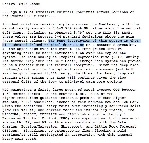
Tropical Depression Harvey is expected to strengthen into a tropical storm and eventually a hurricane before bringing a dangerous combination of rainfall and storm-surge flooding to areas near the Texas and Louisiana coasts into the weekend or early next week.
A hurricane hunter aircraft investigating Harvey Wednesday evening found that it had not strengthened, with wind speeds remaining below tropical-storm strength.
The NHC says the center of Harvey is located about 445 miles southeast of Port Mansfield, Texas, and is sluggishly moving northwest.
Current Storm Information
A hurricane watch has been issued for a portion of the Texas coast, from north of Port Mansfield to San Luis Pass, including Corpus Christi and Victoria. A hurricane watch means hurricane conditions are possible within the watch area. They are typically issued within 48 hours of the expected onset of tropical-storm-force winds.
Tropical storm watches are in effect from Boca de Catan, Mexico, to Port Mansfield, Texas, and from north of San Luis Pass, Texas, to High Island, Texas. This means tropical storm conditions are possible within 48 hours.
Tropical Alerts
The NHC has also issued its first ever public storm surge watch, which includes a swath of the Texas coast from Port Mansfield to High Island, including Corpus Christi and all of Galveston Bay. This new type of watch is issued when there is the "possibility of life-threatening inundation, from rising water moving inland from the coastline" in the next 48 hours, the NHC says.
Harvey is expected to gain strength and will draw near, if not make landfall, somewhere along the Texas coast Friday afternoon or Friday night.
Projected Path
The projected path shows the expected track of the circulation center. Note that impacts such as heavy rain and storm surge can extend beyond this forecast path.
With an otherwise favorable environment that includes deep, warm Gulf of Mexico water, Harvey is currently forecast to strengthen into a hurricane before its landfall, bringing the risk of storm-surge flooding, high surf with battering waves and strong winds.
Various NOAA aircraft reconnaissance missions will provide data that will likely help numerical forecast models determine the exact future intensity and track of Harvey.
Regardless of intensity or track, a major flooding rainfall threat looms, and it may last into next week.
Harvey is expected to be caught in a zone of light steering winds aloft this weekend that will slow or stall the circulation.
Harvey will be wedged between two areas of high pressure aloft, one over the Desert Southwest and a weaker one over the central Gulf of Mexico. Meteorologists call this zone between two areas of high pressure aloft a col.
Potential upper-level steering pattern this weekend that may stall Harvey for some time near or over the western Gulf Coast.
A tropical cyclone's rainfall potential is a function of its forward speed, not its intensity.
Therefore, if Harvey stalls for a period of a few days, it has the potential for producing prolific rainfall, capable of major flash flooding.
Rainfall amounts through next Wednesday could range from 10 to 15 inches, with locally up to 20 inches, over the Texas coast and southwest Louisiana, with heavy rainfall beginning Friday.
Harvey is also expected to produce rainfall accumulations of 3 to 9 inches in portions of south, central and eastern Texas and the lower Mississippi Valley during the same time period.
This forecast is subject to change depending on the exact path of Harvey, locations of rainbands and how long it stalls. Generally, areas along and east of Harvey's path are in the greatest threat of flooding rainfall.
For now, areas near the Texas and Louisiana Gulf coasts are in the biggest threat for torrential rainfall and major flash flooding, potentially including Houston and Corpus Christi.
Among the biggest uncertainties is the heavy rain potential in central Texas, including for the flood-prone cities of Austin andSan Antonio. That all depends on how far inland and to the west Harvey tracks.
Rainfall Outlook Through Monday
While it is too soon for specific rainfall forecasts, areas in red and purple are in the highest threat for flooding rainfall from Harvey through the weekend. Some of this rain may linger into Tuesday or beyond in some areas.
Harvey may still linger over parts of the western Gulf Coast into early next week before it finally moves east. This could spread additional heavy rainfall into parts of the lower Mississippi Valley.
There are even scenarios where Harvey either stalls just off the Gulf Coast or moves back over the Gulf of Mexico at some point after having made landfall, which could allow it to restrengthen for a brief time.
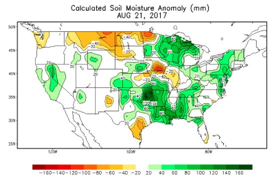
The ground is already quite saturated in many of these areas from what has been one of the wettest starts to August on record.
Harvey's slow movement will also likely lead to additional long-lived impacts from wind.
To the east of Harvey's center, a persistent fetch of south to southeast winds will build swells over the western Gulf of Mexico. As Harvey strengthens, coastal flooding could increase along parts of the Texas and Louisiana coasts as soon as late Thursday, then should peak Friday with Harvey's intensification and landfall.
Given Harvey's expected slow crawl near the coast, this coastal flooding, along with battering waves, could persist in some form through Sunday, if not longer, to the east of the circulation.
Coastal Flood, Waves, Wind Setup
This water rise near the coast may not allow rain-swollen rivers and bayous to drain, compounding the inland flood threat.
Locations in the storm surge watch on the Texas coast (Port Mansfield to High Island) could see a water rise of 4 to 6 feet above ground level along the immediate coast if the peak surge coincides with high tide. This includes all of Galveston Bay.
Storm Surge Alerts
Furthermore, persistent winds, even if not particularly high-end, could down more trees than they otherwise would given the rain-soaked or flooded ground.
Now is a good time to make sure you have a plan in case of both a hurricane strike and flooding. The Federal Alliance for Safe Homes can help you plan for a hurricane. NOAA also has excellent resources to plan for flooding.
One
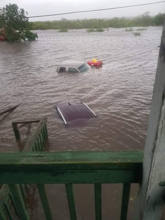
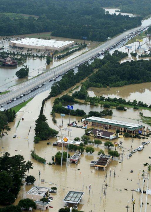
Bossier City, Louisiana, resident described the flooding as looking
like a"horror
movie." Other
state residents described it as the worst they've
seen in their lives. Even
Gov. John Bel Edwards and his wife, Donna, were forced to evacuate.
The
National Weather Service description of this weekend's storm couldn't
be more accurate.
Louisiana's
downpour is being called a "classic
signal of climate change" because
of its extreme nature. And there's a good
reason:
In just 12 hours, the state saw as much rainfall as it should during
a typical three-month hurricane season.
Looked
at another way, some parts of Louisiana experienced a downpour of an
intensity that should occur only once every
500 years.
You
can expect to see more of these kinds of superstorms as the planet
warms, according to the National
Climate Change Assessment,
a study produced by more then 300 experts working with a 60-member
Federal Advisory Committee.
And
it's not expected to get better anytime soon: Weather forecasters
arepredicting that
the La Niña weather pattern will occur again this winter, which is
supposed to bring cooler waters to the Pacific Ocean and drier
weather to the state. So much for a wet winter.
The
takeaway: The old standards of climate prediction are officially
dead.
Meteorologist
Eric Holthaus said that weather prediction is based on the ability of
meteorologists to look at climate data and infer patterns over time.
But because of our changing climate, that's no longer a sure bet, as
extreme weather events that should be rare become more and more
commonplace.
"Statistical
calculations like these make a major assumption: That the climate of
the past is the same as the climate of today," Holthaus
wrote. "That's
no longer a very good assumption."

 Posts
Posts






 Edmon Collins


 Eric Holthaus