Arctic
Warmth Melting Greenland In October
(Anomalous late season melt for Greenland along the coastal regions both north and south. Image source: NSIDC.)
9
October, 2014
It’s
Fall in the Arctic. Temperatures are dropping. Sea ice is expanding.
Snow and frigid weather slowly advance through these extreme northern
lands.
But
the pace of cooling this year — as in recent years — is far
slower than what we would have typically seen just a few decades ago.
For
in a crescent encircling the North Pole from the Laptev Sea through
the Beaufort through the Canadian Archipelago and on into Greenland,
temperatures are ranging between 5 and 12 degrees Celsius above
average (9-20 degrees F). This extra atmospheric heat has tipped the
entire Arctic into a +2.3 positive temperature anomaly — a rather
high range for so early in the season. A strong polar amplification
evident well in advance of a winter which is likely to see total
positive anomalies reach between 3-6 C for the entire Arctic.
(GFS temperature anomaly map for October 9 of 2014 shows the world at a very hot +0.69 positive anomaly above the already hotter than typical 1979-2000 average. Arctic anomalies now average +2.3 C with spikes in the range of +12 C for some locations. Note the +3-11 C hot spot over Greenland. Image source: University of Maine.)
The
oceans are bleeding record or near record heat into the Arctic
atmosphere. The thinned sea ice, in the range of 6th lowest on
record, allows more of that heat to hit the air. High amplitude waves
in the Jet Stream deliver more heat than ever before from the lower
latitudes. An a heavy overburden of greenhouse gasses — at
even higher concentrations than in the rest of the world — traps
more and more long wave radiation trying to escape into space as the
sun’s angle lowers and the long winter night approaches.
For
many regions of the Arctic, what this means is more Summer-like
conditions continuing on into Fall. For Greenland, this has meant
levels of melt that are more than two standard deviations outside the
norm for the month of October.
Greenland
Still Melting in October
Over
Southern Greenland, we’ve seen temperatures in the range of 10 to
-14 C from the coastline to the top of the ice sheet. And over
Northeastern Greenland, we still see temperatures approaching
freezing — an up shot of the warm air and water pool in the ocean
zone between Greenland and Svalbard.
As
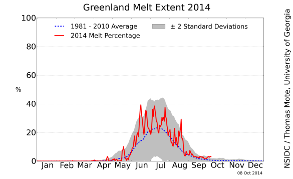
a result of this lingering warmth, NSIDC measures are showing melt
through substantial zones — one around the western coastal region
near the Jackobshavn Glacier and another in Northeast Greenland in
the Zachariae Glacier outflow region. Pushing melt totals more into
the range of what is typical for either late May or early September.
(Greenland melt plot for 2014 showing 3-4 percent of the ice sheet melting during early October. A rate of melt outside the 2 standard deviation range and one that is highly atypical for this time of year. Image source: NSIDC.)
Throughout
the next couple of days, unseasonal warmth is expected to build back
into Southern Greenland and to possibly take root in the northwestern
coastal region. With 5-18 C above average temps expected for many
areas, it is likely that the abnormal Greenland melt will continue
for at least the next couple of days.
As
noted above, conditions remain in place for the Arctic to continue to
experience highly abnormal warmth as Fall continues its advance into
winter — with warmer than normal temperature departures likely to
peak coincident with the deepest periods of Arctic darkness.
Links:
Hat
Tip to Andy


No comments:
Post a Comment
Note: only a member of this blog may post a comment.