Climate
Change Plays Havoc With World’s Weather as Europe/UK Fear Storms
This Fall and Winter
18
October, 2014
Today,
as in recent years, we see ample evidence that extra heat in the
atmosphere and oceans can severely alter weather around the world.
We
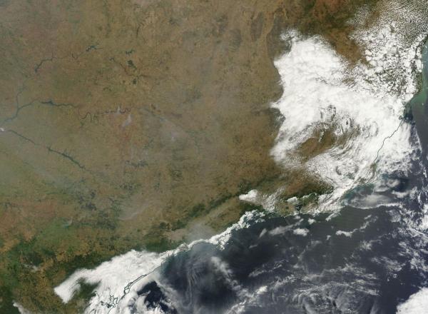
are seeing the impacts in Brazil where Sao Paulo reservoirs are now
at 4.5 percent capacity and millions are suffering from inadequate
and dwindling water supplies. We see similar stress in California
where the worst drought in decades is forcing some communities to
truck in water.
In
Syria the situation is even more dire — on the scale of a
humanitarian nightmare — where
a multi-year drought has destabilized government and spurred violent
extremism to surge through an already troubled region.
(Sao Paulo region of Eastern Brazil clearly visible through a mostly cloudless but smoke-filled satellite shot on October 15. Note both the dessicated, browned land of a normally green region together with the steely gray smoke funneling in from wildfires both near Sao Paulo and further north in the drying Amazon rainforest. Intense heat and lack of rainfall combines with fires to create a pallor of smog over much of Brazil also visible here. Image source: LANCE-MODIS.)
In
a warming world, drought and deluge are far more common. The added
heat increases the rate of evaporation and amplifies the hydrological
cycle such that the atmosphere holds
6 to 7.5 percent more moisture per each degree Celsius of heating.
This is roughly equal to an increase in the rate of evaporation and
precipitation by 6 to 7.5 percent as well. So where droughts occur,
they will tend to be more severe and where strong storms develop,
they will tend to dump even heavier volumes of rainfall. And
a warming of the polar regions coincident with snow and ice loss,
plays havoc with both the Jet Stream and traditional storm tracks
even as the increased instability generates ever-more-powerful
storms.
For
a Europe facing off against an Atlantic and Arctic undergoing these
wrenching changes, the story is altogether related. Sections of
Southern France over a recent six week period received enough rain
for an entire year. The Mediterranean waters off this region had
heated to between 3 and 4 C above average dumping an intense load of
moisture into a hungry upper level low that delivered storm after
storm to the beleaguered regions. One
spate of deluge dumped a full six months of water from the skies in
just three hours.
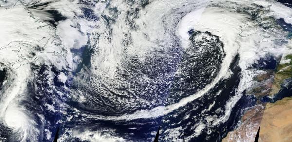
(Monster storm that bombed out to 952 mb on Wednesday lashes the UK and Ireland with rain and gales on Friday and Hurricane Gonzalo threatens Bermuda. Gonzalo is set to make an eastward turn across the Atlantic and will possibly impact the UK as a tropical storm by Monday or Tuesday of next week. Image source: LANCE-MODIS.)
This
week, one such storm swelled to extraordinary intensity in the North
Atlantic. On Tuesday and Wednesday it bombed out to a powerful 952 mb
monster, filling up most of the Ocean between Newfoundland, Greenland
and Europe, casting gales on into the UK and Ireland. It sent storm
surges up rivers — forcing them to top their banks, lashed the
isles with rainstorms that flooded Belfast, damaged hundreds of
homes and
sent officials scrambling to assure an already storm-weary public
that they were better prepared for such events than last year.
The
current storm is expected to rake through the UK and Ireland
throughout this weekend before fading off toward the north. As it
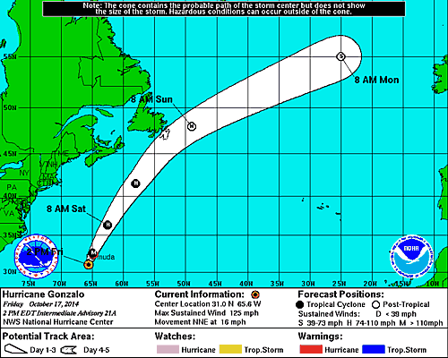
lifts, hurricane Gonzalo — now packing 125 mph winds and
threatening Bermuda — is forecast to surge into the UK with
tropical storm intensity come Monday or Tuesday of next week.
(Forecast path for Gonzalo shows a tropical storm off Ireland by Monday morning. Image source: NOAA.)
The
1-2 punch is reminiscent of a relentless series of storms that
battered the UK this past winter. A sequence spurred by extraordinary
and unprecedented changes to the North Atlantic climate including a
slowing of the Gulf Stream, a powerful warming of surface waters in
the Arctic, major losses to sea ice in almost all Arctic seas, and
increasing cold, fresh water outflows from Greenland. The net effect
is to enhance storm track intensity across the Atlantic as warmer
waters and airs surge northward coming increasingly into contact with
cold polar air and generating powerful and intense storms during the
winter, fall, and spring seasons.
With
global temperatures flirting with new record highs and with El Nino
possibly flaring to life in the Pacific, the end of 2014 and the
start to 2015 is altogether likely to see a continuation of such
intense, extreme weather. Weather that is severe enough to cause
damage and disruption in some areas or even powerful enough to throw
whole cities and regions into instability.
Just
a few of the tragic results of a warming climate as we approach the 1
C above 1880s temperatures mark.
Link:
Hat
Tip to Colorado Bob
Hat
Tip to Bernard


No comments:
Post a Comment
Note: only a member of this blog may post a comment.