Showing posts with label Westland. Show all posts

Sunday, 29 March 2020

New Zealand has its first death from coronavirus


First death in New Zealand 

from Covid-19


RNZ,


29 June, 2020


Dr Ashley Bloomfield and Prime Minister Jacinda Ardern have confirmed a 

person has died with Covid-19 in New Zealand.


Watch here:


Dr Bloomfield said New Zealand had its first death after a woman who was 
initially diagnosed with influenza died.

The woman who died was in her 70s, from the West Coast. She died this 
morning at Grey Base Hospital in Greymouth. She had tested positive for the 
virus on Friday.


"Understandably the family would like to take their time to grieve," Dr 
Bloomfield said.


"This latest sad news reinforces our move to alert level four."


He said 21 DHB staff who treated the woman when her diagnosis was thought 
to be influenza had been asked to self-isolate.


Dr Bloomfield said she was in hospital for two or three days before being 
tested for the virus.


He said there was a link to overseas travel but that was still being investigated.

No other close contacts of the woman had been tested yet.


He said there were 63 new cases of the virus including 60 confirmed cases 
and three suspected cases. It brings the total to 514 cases in New Zealand.


"We are still seeing a strong link to overseas as well as travel."


He said the contacts were still being followed up, but he felt certain the 
number of cases of community transmission would continue to rise, which was 
why thlevel-four alert was in place.


Prime Minister Jacinda Ardern said this would be an enormously difficult time 
for the family of the person who died.


She said she knew the thoughts of everyone from around the country would be 
with the family.

She said the death was an example of "exactly why" New Zealand had gone 
into lockdown to deal with the Covid-19 outbreak.

"It also brings home exactly why we are taking such strong measures to stop 
the spread of this virus," she said.

"Our older New Zealanders and those with underlying health issues are by far 
the most at risk ... our shield of protection for these people is physical 
distance."


"Today's death is a reminder of the fight that we have on our hands ... stay at 
home, break the chain and save lives."

She said more than 1800 tests were carried out in the past day, despite it 
being a weekend.


"I do worry that our older New Zealanders who may have a tendency to not 
wish to be perceived to be putting anyone out, may not be asking for the help 
that we need to give them.

"I want to again restate, you must stay home."

She implored people - particularly parents and those who were elderly or with 
underlying health conditions - to stay home as much as possible.

"I have had a number of people say to me that they have not been able to 
convince their parents to listen to the advice.

"Anyone out there who's over 70 or has underlying health conditions who is 
not listening to their children, please listen to me. You must stay at home. It's 
devastating to lose anyone, it's devastating to lose a parent, I don't want that 
to happen to your children. Please stay at home."


Ardern also warned against what she said amounted to bullying on social 
media.


She also said police had confirmed they had all the resources they needed 
including the ability to arrest if need be.

She said 840 people arrived from overseas yesterday, but the numbers of 
arrivals were falling significantly.

"We have to keep in mind though that returning New Zealanders through no 
fault of their own do carry the greatest risk."

After reports about inflated supermarket prices, Ardern would not say 
whether the government planned to freeze supermarket prices but the 
government was looking at specific cases of prices for specific goods.

She said she would give a fuller update on a variety of concerns about 
supermarkets, including whether immune compromised workers or those aged 
over 70 were being asked to take annual or unpaid leave during the lockdown.

She also said the government was aware of the problem of people being able 
to source halal meat and was looking at solutions.

The government had also seen concerns about the shut-down of distribution 
of magazines and community newspapers, and said the government was 
trying to find a way to use existing distribution that could guarantee public 
health measures in the printing and distribution.


"The old forms of distribution ... just would not work in the current 
environment."

Dr Bloomfield said the Ministry had been able to collate some statistics which 
showed Māori were about 4 percent of New Zealand cases, and Pacific 
Islanders 2.3 percent.


the day before.


There are expected to be no further official updates today.

Grey Power's response

The Grey Power president says the woman's death will be of great concern to 
many elderly people.

Mac Welch said the dozens of people he had spoken to have all said they are 
taking the threat very seriously, and following the precautions religious.


Welch said he hadn't heard of anyone flouting the precautions implemented by 
the government to prevent the virus' transmission.

More than 660,000 infections have been confirmed globally and more 

than 30,000 deaths, according to figures collated by Johns Hopkins 

University. Nearly 140,000 patients have recovered.

Coronavirus cases around the world

  • United States - 123,000 cases, 2000 deaths
  • Italy - 92,400 cases, 10,023 deaths
  • China - 82,000 cases, 3300 deaths
  • Spain - 73,235 cases, 5982 deaths
  • Germany - 57,700 cases, 433 deaths
  • France - 38,100 cases, 2314 deaths
  • Iran - 35,408 cases, 2517 deaths
  • United Kingdom - 17,312 cases, 1019 deaths
  • Switzerland - 14,076 cases, 264 deaths
  • Netherlands - 9018 cases, 639 deaths
* Data from latest Reuters, BBC and Johns Hopkins University


Two days ago I posted information from a friend that the 


Hutt Hospital had been put under lockdown because 

there are two patients with coronavirus. This is 

confirmation but I am unsure whether this is general or 


not.


Read more details HERE


Monday, 9 December 2019

Weather mayhem in New Zealand over the weekend

This report is abridged. See the original for full report

Recap: Weather mayhem leaves tourists stranded, major roads closed

The government announced this afternoon it may call in Air Force helicopters to evacuate some of the hundreds of tourists trapped in Franz Josef.
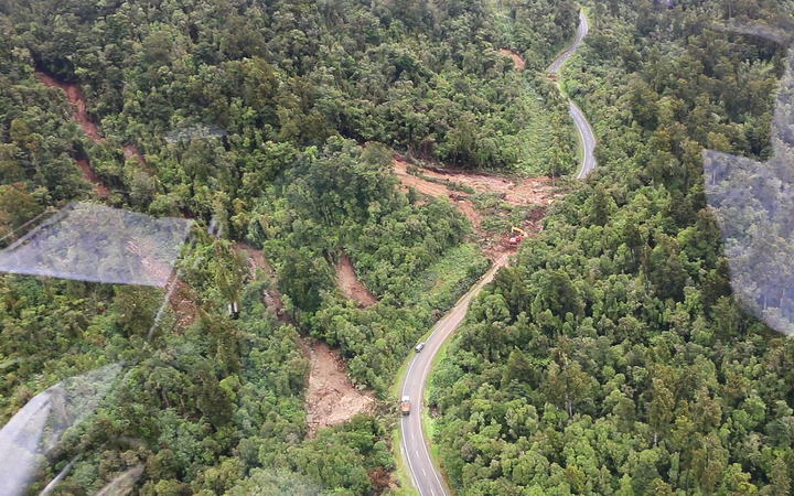
Mt Hercules slip
RNZ,
9 December, 2019

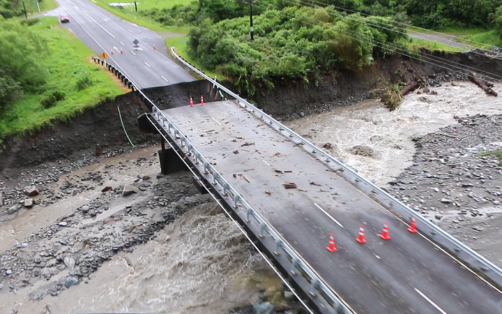
The highway from Hokitika to Franz Josef has been closed since Saturday after heavy rain over the weekend caused several washouts and slips along State Highway 6, and left hundreds of tourists and locals stranded in the region.
The road to the south of the town may not be open until Friday, and the road north is expected to take at least two weeks to clear.
It was hoped that by the end of today road crews would have a better idea of when the road south could be re-opened.
The township of Fox is also cut off, as are dairy farms in Whataroa, where they'll be having to start dumping milk today because no tankers have been able to get through since Friday.
A generator has helped restored power to Fox Glacier today where power had been out to some parts since Saturday.
About 1000 tourists and locals showed up to a town hall meeting at Franz Josef this morning at which the Civil Defence Minister, Peeni Henare, sought to reassure people.
He told them to register their names with Civil Defence if they did not have travel insurance, or had children or medical needs that meant they'd need help to get out of Franz before Friday.
Helicopter companies were flying people out but at a price ranging from a few hundred to a few thousand dollars.
Mr Henare said a free ride on an Air Force helicopter was something the government was willing to consider.
Bridge washout just after Mt Hercules heading south
Photo: RNZ / Conan Young
"Those are some of the support mechanisms that I know that we can put in place, which is why it's important to get a true picture of the need here. We know that insurance will cover for those who have insurance and for those that don't then that's when we really got to kick into gear and make sure we can support them the best way that we can."
Inflite Group, which operates scenic flights and skydive operations, has brought in extra aircraft from around the South Island to manage the demand for air tickets out of Franz Josef.
Spokesperson Dan Burt told RNZ the first people were flown out at 7.30am today, using aircraft relocated from Queenstown, Nelson and Aoraki/Mount Cook.
"We're taking a lot of people through to Mount Cook Village because we've got road transport operations available - we've got vehicles and buses available. Those people are going through to Queenstown while others are heading to Christchurch which has to be by air at this stage."
Mr Burt said passengers were being given a scenic flight as part of their ticket, and the company had offered to manage the return of rental vehicles left behind in Franz Josef.
In the meantime, extra food supplies such as bread, milk, and fresh fruit and veggies were being flown in this afternoon.

One bridge north of Timaru reopens

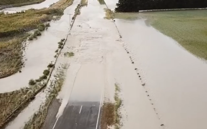
Timaru entered a state of emergency over the weekend, when torrential rain caused the Rangitata River to overflow and cut off access to the region. Subsequently, Rangitata Bridge on SH1 and the bridge at Arundel on SH72 had to be shut.
But the council said the reopened road would still be bumpy with some unsealed sections, and people who could postpone their journey should hold off until the main surge of held-up motorists was through.
Speed restrictions were in force and people were also advised to carry food and water for the trip because of the limited services enroute. Localised detours were also in place from Orari.
Rangitata River remains flood on Sunday 8 December, 2019.

On the West Coast, a number of power poles had come down along with the Chorus fibre attached. Once the electricity provider in the area restores its network then Chorus can restore its own network.
Chorus technicians plan to put a temporary fibre cable at Arundel so that broadband and phone services can be restored quicker, but assessment of another damaged fibre at the Rangitata Bridge on SH1 cannot be completed yet because of the flood.
Emergency accommodation for those evacuated is available at the Southern Trust Events Centre, 70 Morgans Road.
What to expect for the weather in coming days
MetService says a settled period of weather should allow the clean-up to get under way.
It said the front that brought the weekend's wild weather was now only having a few lingering effects on the East Cape of the North Island.
Meteorologist Andrew James said there was generally clear conditions ahead with a few showers but nothing like what had been seen in the last few days.
"We've got a good couple of days of weather down there for the clean-up operation."
NIWA meteorologist Chris Brandolino said well over a metre of rain had fallen in the West Coast in the past eight days.
"Even the lower elevations, Milford Sound [there's been] 608mm of rain ... they normally get 700 in the entire month of December. When you're getting 80 or 90 percent of your monthly rainfall in seven or eight days, that causes problems."
While skies are beginning to clear over Timaru today, more active weather and potentially with heavy rain could be expected again towards the end of the week and most likely the weekend.
However, James said the rain expected later this week would be nothing like the deluges that hammered both sides of the island in the last few days.

Sunday, 4 August 2019

Storm surge turns homes into islands on West Coast New Zealand


Alone in a wild ocean, New

Zealand gets smashed by 

some of the world's biggest 

waves 


Stuff,
4 August, 2019

Far from any other piece of land, and sitting among some of the wildest waters on the planet, New Zealand has some of the world's biggest waves.

Massive seas hitting the south and west of the country this weekendshow what can happen when conditions are right. And as is most often the case, it's the south and southwest of the country that's taking the biggest pounding, followed by the west coast.

And there's plenty of coastline to batter. Land Information NZ puts the length at 20,500km, with 6000km around the South Island, 8500km around the North Island and 700km for Stewart Island. Outer islands account for the rest.

Ed Atkin, oceanographer at marine and freshwater consultancy eCoast, said the 8-11m inshore waves forecast for Friday and the weekend were "very substantial" in the grand scheme of things.

READ MORE:
Massive wave south of NZ believed to be a Southern Hemisphere record
Eating the shore: New Zealand's shrinking coastline
King tide flooding leaves Auckland residents cleaning up 'heartbreaking' mess
​Because New Zealand had sections of coast facing all directions of the compass, different parts of the country experienced distinctly different wave climates, he said.

Much of New Zealand's wave climate was dominated by storm tracks around the globe in the Southern Ocean. "These storms generally generate the largest waves on the planet. Our west, south and southeastern extremities of New Zealand are right in the path of these storms and the waves they produce." Waves as big as 11 metres had been recorded around Southland, Atkin said.

Far from any other piece of land, and sitting among some of the wildest waters on the planet, New Zealand has some of the world's biggest waves.
GLENN JEFFREY/STUFF
Far from any other piece of land, and sitting among some of the wildest waters on the planet, New Zealand has some of the world's biggest waves.

The northeastern parts of New Zealand tended to have a smaller wave climate on average, but could experience extreme wave and weather events when cyclones made their way down form the tropics.

Why are the waves around New Zealand so big?
A 1979 paper by RA Pickrill and JS Mitchell from the NZ Oceanographic Institute explains this neatly.

The country is wholly within a belt between latitudes 30deg and 70deg where westerly winds blow around the Southern Hemisphere virtually unimpeded by any large land masses. "Waves dominated by these westerlies dominate the wave climate on most of New Zealand's coastline," the paper said.

New Zealand Defence Force offshore patrol vessel HMNZS OTAGO battered by huge seas in the Southern Ocean.

"New Zealand is isolated from other large bodies of land. In almost every direction fetch (the area of ocean over which the wind blows in an essentially constant direction) conditions for wave generation are unlimited; Australia is the closest neighbour, 2000km to the northwest, and for all but extremely rare events this represents unlimited fetch conditions for wave generation."
Niwa coastal and estuarine physical processes scientist Dr Richard Gorman spells it out:  "As the wind blows across the sea, it transfers some of the energy to the water surface. The longer it blows and the stronger it is, the larger the waves."
Where are the biggest waves in New Zealand?


IAIN MCGREGOR/STUFF
Penny Madden's home in Hector, north of Westport, was hit by a huge sea swell during a storm in early 2018.
The south and west coasts of both islands get the highest energy waves, driven by the predominant westerly flows, Niwa said. The energy grading was highest in the southern South Island and lessened further north.

On the northeast coast of New Zealand, from North Cape to East Cape, the landmass provided shelter from the Southern Ocean, and waves were driven by weather systems in the Tasman Sea and ex-tropical cyclones. "Generally waves are smaller there, but occasionally you can get big waves in cyclone conditions," Niwa coastal scientist Dr Scott Stephens said.

And on the coast from Gisborne to Otago, waves usually arrived from the south and east. Although Cook Strait could experience wave conditions choppy enough to cancel ferry crossings, it was sheltered from large ocean swells and more affected by local winds.
So how big?


ALEX CROUCHER/YOUTUBE
Offshore patrol vessel HMNZS Otago was battered by a heavy storm during an operation in the Southern Ocean in late 2015.
There isn't a comprehensive record of measurements from around the coastline, but it's possible to get some idea of how big the seas can get from what is available.

Starting with the biggest first. MetService subsidiary MetOcean Solutions measured a 23.8m giant at a buoy in the Southern Ocean during a storm in May 2018.  It was thought to be the biggest wave ever recorded in the Southern Hemisphere, even though it was unlikely to have been the biggest wave during the storm. Individual waves higher than 25m were possible, MetOcean said.

A Niwa report on renewable energy resources said the wave energy resource to the south of New Zealand was "exceptionally high" by world standards. Higher resource areas were also most likely to experience the most extreme, damaging wave conditions. For example, a one-in-100 year wave could have a 35m trough to peak height.

Niwa reported that during a storm in June 2013, 15m waves were recorded at a buoy 2km off Wellington's Baring Head. They were the largest recorded at the buoy since measurements started in 1995, and Niwa thought they were likely to be the largest at that point in 50 years.

During a big storm on Waitangi Day 2002, the biggest waves were 13m off Baring Head. The significant wave height during the 2002 storm was above 8m.

Niwa's Gorman said Fiordland had some of the country's highest waves. Wave heights averaged 3m on a typical day, but reached over 10ms at times. Wave heights in the North Island averaged around 2m on much of the west coast, and 1m on the east coast.

Anecdotal information recorded the wave height at the time of the 1968 Wahine disaster at 12-14m.

What about further back in time?


JED FINDLAY
Waves smashing into SH6 at Punakaiki were so big concrete was "thrown across" the road, in a storm in early 2018.
The biggest storm to hit New Zealand in the 20th century is thought to have happened in February 1936. The Wahine storm of April 1968is thought to have been the second biggest. Niwa said the 1936 storm was thought to be an ex-tropical cyclone, which "swept with cyclonic fury" through the North Island. "Phenomenal rainfall and extreme winds caused widespread damage and destruction of property throughout the North Island."

Te Ara The Encyclopedia of New Zealand records 40 boats were sunk or driven ashore in the Waitematā Harbour, and chillingly in hindsight, the interisland ferry Rangatira steamed onto rocks on Wellington's south coast. Unlike the Wahine in 1968, the Rangatira avoided disaster, managing to reverse off the rocks after 20 minutes, then turning and backing slowly up the harbour.

During the 1968 Wahine storm, a woman was injured at Waihi when waves washed through a beach cottage. In Whakatāne, huge seas were driven inland, flooding many hectares of coastal farmland. Also at Whakatane, huge waves smashed a concrete retaining wall and washed logs across the road.

And then there was the six-day storm of February 1868, which is also thought to have been an ex-tropical cyclone. Niwa said there were 12 shipwrecks during the period, and at Waikouaiti in east Otago, waves washed away or levelled several buildings storing goods on a sandspit.
What's the general picture?


SVEN MARTIN
Waves pound the Boulder Bank at Glenduan north of Nelson in early 2018.
The Pickrill and Mitchell paper said the country could be divided into four broad regional groupings on the basis of wave characteristics.

In Southern New Zealand the wave environment was "extremely high energy", with the prevailing deep water wave being 3.5-4.5m high. Rarely did wave heights drop below 2m, and waves up to 11m had been recorded.

In Western New Zealand, off the west coast of central New Zealand, prevailing deep water waves were 1-3m high, changing to 0.5-1.5m when seen from the beach. While this grouping was also exposed to the prevailing winds, the westerlies were not as strong as those further south, and that was reflected in the lower wave height.

The Eastern New Zealand area, which was sheltered from the prevailing winds, had prevailing deep water waves 0.5-2m high. Onshore that was transformed into a 0.5-1.5m wave. Storm waves on the east coast were rarely more than 3m high, except on the south Wellington coast where southerly wave trains arrived at the shore unrefracted and storm waves may be higher than 4m.

In Northern New Zealand, the area between North and East capes - had a 0.5-1.5m deep water wave, which was probably transformed into a 0.4-0.8m wave at the beach. Storm waves at the shore were probably only occasionally more than 2.5m high.

What have king tides got to do with all this? In fact, what is a king tide?


CATRIN OWEN/STUFF
A king tide coinciding with a storm closed Tamaki Drive in Auckland in early 2018.
According to the US National Oceanic and Atmospheric Administration,"king tide" is a non-scientific term often used to describe exceptionally high tides. Higher than normal tides typically happen during a new or full moon, and when the Moon is at the closest point to the Earth during its orbit of roughly 28 days.

That closest point is perigee, and when it happens the gravitational pull of the Moon on the Earth is at its strongest, and during those periods there is a slight increase in the average range of tides.

Also during full or new moons - when the Earth, Sun and Moon are nearly in alignment - average tidal ranges are also slightly larger. These happen once a fortnight.


About three or four times a year, when the new or full moon coincides closely with perigee, the tidal range is even bigger, although not by much. But at these times coastal flooding from a storm could be significantly worse than it otherwise would have been.
 The landfill in Foxton Beach was closed 24 years ago, but is close to the Manawatū Estuary in amongst the sand dunes.


Horowhenua mayor Michael Feyen said locals had grown increasingly concerned following the Fox River disaster, with contractors from the area offering their services to reinforce the dunes.

Mr Feyen said one local contractor took him there so he could see how wet it was getting with his own eyes.

"Over the years people will say the water has been this high before with flooding and spring tides, but he said to me I've never seen it like this before.

"The ground is permanently wet up here."

Locals had seen the river change course multiple times and suspected its next change would cut north - the direction of the landfill, Mr Feyen said.

"We are really concerned that the water is only really got that sand bank to go and it's into the dump. We don't want another Fox River do we?"

Rising water levels could not be disputed by anyone, and sand did not take much to be washed away, he said.

However, a Horowhenua District Council spokesperson said the sand dune which protected the dump site from the river was safe for now.

The spokesperson said the sand bank was "stable at present" but it was working to ensure the land stayed that way.

The council was creating plans to educate locals around how to protect the area, such as by driving responsibly when using vehicles on the beach.

https://www.rnz.co.nz/news/national/395921/concerns-spring-tides-could-unearth-old-dump-in-foxton?fbclid=IwAR0d3-6jo0EIEV90LR1ktscpaQtxY4t6mfbJ4R97neWjG3jB7M4Mand3xEs