Showing posts with label Bering Strait. Show all posts

Wednesday, 12 June 2019

The beginning of the Arctic sea ice melt season - 11 June, 2019


I had a message from a friend saying that her friends holidaying in Svalbard from the UK were getting around in shorts and T-shirts!
An early- season assessment 
of Arctic sea ice – 11 June, 
2019

It is very difficult to truly assess the ice and compare it to previous years. I have made an attempt to paint a picture from all the clues available - air temperatures, sea temperatures and data relating to temperatures in the Central Arctic Basin.

The picture is not very pretty as if seems to me that the ice is not only melting earlier, is thinner and in much worse shape than in previous years.

Whether we set a "Blue Sea Event" (technically, the disappearance of at least 80% of sea ice extent is anyone's guess and may largely depend on weather conditions as the melt season progresses.

In the meantime, the Arctic sea ice is being eroded from below as is clear from the CNN video below.

This time last year I was not yet following the melt season (I started in July when I started working with Margo). I shall provide comparisons with last year in due course.

Here is my video report:


***

This GIF shows the thinning ice.


And the present sea ice concentration


I neglected to show these pictures from NASA 
Worldview.

First a general view of the Arctic basin with melting 
around the edges in progress.


This shows the situation in the Barents Sea, from 
Svalbard up to Western Siberia -  Novaya Zemlya and 
the Yamal peninsula


The Beaufort Sea between the Canadian Arctic archipelago and Alaska.


The Bering Sea, between Alaska and Siberia


LINKS:

Arctic melt: Threat beneath the ice

We know the Arctic is experiencing a vast melting of sea ice. But deep in the ocean, something is happening that scientists are still trying to fully understand


https://edition.cnn.com/2019/06/08/world/arctic-beneath-ice-intl/index.html?fbclid=IwAR31yrTg6ZH5Xuz8Z2Y5BcXFn24rYBdaUUQ1hKZxs3Krj1B4yhMZpJtXVIQ

This is the video from the above article.

Arctic ice has very big problem because climate change | ice faces trouble from above and below


https://www.youtube.com/watch?v=fSOHlw9KF3U&feature=share


The latest from Sam Carana and the Arctic Blog

When Will We Die?


The outlook for people living now is that they will die before the end of the century. After all, even in more developed regions, people statistically die at an age below 75 years, as the image on the right illustrates.


The image calls up questions regarding possible shortening of life expectancy due to global heating.


http://arctic-news.blogspot.com/2019/06/when-will-we-die.html


Arctic ice has very big problem because climate change | ice faces 

trouble from above and below


For the longest time the story of ice melt has been about rising air temperatures. But what is happening under the sea ice? CNN's Arwa Damon heads out with a team of scientists to the far corners of the Arctic Circle to find out.
Source: CNN


Monday, 15 April 2019

Conditions in Bering Sea were predicted for 2050, not 2019


Bering Sea has reached climate conditions not expected until 2050, scientists say
  • The Bering Sea saw record-low sea ice last winter, with flooding in nearby areas
  • However, oceanographer Phyllis Stabeno says it’s too early to attribute the changes to climate change and she expected a bounce-back this winter.

14 April, 2019


Scientists who study the northern Bering Sea say they’re seeing changed ocean conditions that were projected by climate models – but not until 2050.
The rapid changes are leading researchers to wonder if ecosystems near the Bering Strait are undergoing a transformation.

The Bering Sea saw record-low sea ice last winter. Oceanographer Phyllis Stabeno says it’s too early to attribute the changes to climate change and she expected a bounce-back this winter.

Instead, warm February winds cleared most of the Bering Sea of ice.

University of Alaska Fairbanks physical oceanographer Seth Danielson says the changes are triggering biological effects.

Commercially valuable fish such as walleye pollack and Pacific cod moved farther north last year. Seabird experts say a seabird die-off that occurred may be tied to changing ocean conditions.


Monday, 8 April 2019

The Bering Sea Should Be FROZEN Right Now. It ISN'T!


From a Christian source that normally associate with climate change denial
MYSTERY HEAT at NORTH POLE! The Bering Sea Should Be FROZEN Right Now. It ISN'T!


On April 6, 2019, Arctic sea ice extent was 13.01 million km², a record low for the measurements at ads.nipr.ac.jp for the time of year.

---Sam Carana

Image may contain: text

Monday, 11 March 2019

Near-complete loss of sea ice in the Bering Sea withn weeks


Bering Sea Meltout


8 March,2019

The big story in Alaska climate at the moment is the near-complete loss of sea ice in the Bering Sea in recent weeks.  Unrelenting warm southerly flow has reduced Bering Sea ice extent to a record low level for the date, dropping below even last winter's remarkable ice shortfall.  The climatological peak in Bering ice cover occurs at the end of March, but the latest daily ice extent of only 150,000 km2 is more typical of about June 1st, according to the 1981-2010 normal.

With only about 20% of normal ice cover for the date, the current anomaly is the greatest percentage shortfall (relative to normal) between about mid-December and mid-April (mid-May prior to last winter), so it's safe to say that such an extreme absence of winter ice has not been observed previously in the modern satellite record.


It's also of interest to note that the last 40 days have seen a decrease of 417,000 km2 in sea ice extent, and a 40-day loss of this magnitude has not previously been observed this early in the season.  The earliest was between mid-February and late March of 2002, but that was starting from over 900,000 km2.

Here's today's ice analysis from the National Weather Service (click to enlarge).
A few days ago the NWS map was also showing considerable ice loss north of the Seward Peninsula and in Kotzebue Sound, and today's satellite imagery suggests (to me at least) that the remaining ice in this area is broken and insubstantial.  The image below (3pm AKST today) is rather obscured by clouds, but the Seward Peninsula and a dark-looking Kotzbue Sound are visible just to the right of center.


A webcam image from Kivalina this afternoon also suggests there is a lot of open water in the southeastern Chukchi Sea; note the obvious dark band along the horizon.

The Iditarod mushers will be reaching the Bering Sea coast tomorrow, but unless the teams need to cool off, it seems they'll be confined to land as they travel up to Nome.  Here's the ocean view from Shaktoolik this afternoon.  Air temperature: 37°F.

Saturday, 2 March 2019

Huge loss of sea ice in the Bering Sea

Zack Labe: the loss of sea ice in the Bering Sea is unbelievable


To get your bearings you may have to mentally turn this image upside down.


Here is the graph for Bering Sea ice - just a hair's breadth short of 2018


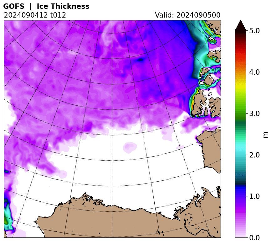
This is the sea ice thickness in the neighbouring Beaufort Sea


And temperature anomalies in the Arctic as of 2 days ago


Tuesday, 3 April 2018

Another snowstorm as Arctic warms

Seven Inches of Snow Dumped on Northeast as Another Major Arctic Warm-Up is Underway

2 April, 2018

As an April snowstorm strikes the U.S. Northeast, major global weather stories related to climate change are unfolding in real time. For today, we again find that none of the key climate zones feature below average temperatures even as a ten-day-long Arctic warm spell appears to be on tap.

Very Warm Arctic in Early April
(Another big Arctic warm-up drives cold air southward. The result is snow over the U.S. Northeast even as parts of the Arctic Ocean are experiencing an early thaw. Image source: Climate Reanalyzer.)

Warm winds driving northward over eastern Siberia, on the back side of a high pressure ridge, are delivering yet one more big dose of near or above freezing temperatures to this Arctic region. From the Chukchi Sea through the Bering Strait and on into East Siberia, temperatures range from 10 to 22 degrees Celsius above average. The Bering itself has been mostly swept clean of sea ice — with severe record low ice extent readings for this zone during early April.


Throughout winter, the Bering and Chukchi have received wave after wave of much warmer than normal air from the ocean zone to the south. This tendency for warm air propagating northward through the Pacific is one that is often triggered by La Nina — a periodic pattern of Pacific Equatorial surface water cooling that became a dominant feature of 2018 winter weather. However, globally warmer than normal ocean waters and, in particular, much warmer than normal sea surface temperatures in the Northeastern Pacific appear to have greatly enhanced the heat influx.

(Much warmer than normal sea surface temperatures in the Northeastern Pacific this year have provided a pathway for warm air to invade the Arctic. Meanwhile, La Nina and Polar Amplification generate a combined influence that weakens the Jet Stream and facilitates atmospheric ridges in this zone. Image source: Earth Nullschool.)

These warm waters at the middle to northern latitudes have developed a pathway that enhances the northward flow of tropical air masses over the Pacific Ocean. Meanwhile La Nina’s Equatorial cooling combines with climate change’s amplified polar warming to slow down the Jet Stream — further enabling this south-to-north heat transfer. As we have seen time and time again, human-forced global warming generated chiefly by fossil fuel burning is developing an atmospheric and oceanic handshake with past understood synoptic trends to produce an out-sized Arctic warming.

Bering Sea Almost Completely Cleared of Ice

This severe warming is plainly visible as open water is driven by outlandish temperatures well north and through the Bering Strait during early April. A time when ocean ice typically extends more than 150 miles south of Ninivak — bridging the water zone from Bristol Bay to the Kamchatka Peninsula.
(The Bering Sea is typically ice-choked during April. And during a normal year all the water zones in the above image would be covered with ice. But this spring, sea ice extent there is at never-before-seen record low levels. Image source: NASA Worldview.)

The impact is quite dramatic. During February, Bering Sea Ice hit 100,000 square kilometers below previous record lows for the Month. These record low extents continued throughout March and into early April when, today, we find that Bering sea ice extent is between 150,000 to 200,000 square kilometers below the previous record lows for the dayand about half a million square kilometers below the seasonal average.

Putting this loss into context, half a million square kilometers is a region that splits the difference in size between the land mass area of California and Texas.
According to GFS model runs, the present Bering-East Siberia warm spell should last for another 2-3 days even as larger Arctic warming in the range of 2.4 to 3.2 degrees Celsius above average for the entire 66 North Latitude zone and on poleward is expected to continue through the ten day horizon. These warmer than normal temperatures should retard typical seasonal sea ice thickening in the far northern regions even as edge ice zones like those in the Bering, Baffin Bay, and the Sea of Okhotsk experience early spring melt and erosion.

New England Spring Snow

As warm air invades the Arctic — a feature that has become more and more prevalent as the globe itself has heated up — it tends to drive cold air southward over the North American, Asian, and European Continents. In this case, the warm air invasion coming from the Siberian side is displacing Arctic air over North America. As a result, and much to the delight of myth-enraptured climate change deniers everywhere, we have been treated to a rare, if not unheard of, spring April snowstorm in New England.
(Increasingly, there have been indications that polar warming related to global warming is influencing storm tracks and ridge and trough patterns in the Northern Hemisphere Jet Stream. The result is a stronger influence on Mid-Latitude Northern Hemisphere weather. Image source: Arctic Change and Possible Influence on Mid-Latitude Climate and Weather.)

According to local weather reports, as much as 7 inches of snow were dumped in intense 2-inch-per-hour bursts over parts of New England last night as a brief but intense storm roared through the region. The cold air, driven south by the recent warm polar air invasion, encountered high atmospheric moisture levels bleeding off a much warmer than normal Gulf Stream lurking just off-shore. The result, as has been the case during recent intense rain and snowstorms, was enhanced convection. This greater atmospheric uplift, in turn, produced an out-sized spring precipitation event. With below freezing temperatures driven far to the south by warm air entering the Arctic, the Northeast saw its first significant April snow event since 1982.

An April 6th to 7th Snowstorm for the U.S. South on the Way?

Further fodder for the climate change denial community supported by the anti-information campaigns of Fox News and others, may emerge by next weekend as another big push of cold air could help to develop a snow and ice storm stretching from Oklahoma through the Carolinas. Cold air driven out of the Arctic and southward over the Eastern and Central U.S. could result in 10 to 18 degree Celsius below average temperatures in that region. Moisture bleeding off the much warmer than normal Gulf of Mexico and Atlantic Ocean could be injected into this cold trough as a related storm develops. The result is a potentially unusual snow and ice storm. And an intense event off this kind, should it develop, would be a very odd weather event during U.S. spring-time.
(Another odd spring U.S. Snowstorm may be on the way for April 6th and 7th according to GFS model forecasts. Image source: Tropical Tidbits.)

Meanwhile, the U.S. tendency in the model forecasts is for warmer than normal temperatures in the West, cooler than normal temperatures in the East through the middle of April. It’s worth noting that the forecast also shows highly variable temperatures with strong swings between warm and cold throughout this period for most U.S. regions. As a result, as the Arctic remains much warmer than normal over the next ten days, the U.S. is likely to experience periods of both extreme warmth and extreme cold relative to climatological averages for this time of year.
Final Points — Intense U.S. Spring Snowfall Events a Likely Upshot of Polar Warming

Putting all these dynamics into context, we can sum up by making the following statements:
  1. April snow and even April blizzards are not unheard of for the U.S. East. That said, the recent events are odd and outside the context of regular U.S. weather patterns — particularly when it comes to precipitation intensity.
  2. Arctic warming and loss of regional sea ice, such as that seen in the Bering, is historically unprecedented during 2018. This is a continuation of an observed trend of polar amplification and severe warming seen during recent years.
  3. No major global climate zones show below normal temperatures on April 2, 2018. That said, a high variance in middle latitude northern hemisphere temperatures presently exists — with regions of intense cool and intense warmth interspersed.
  4. Snowstorms in the U.S. Northeast during April do not disprove global warming or a related shift to increasing climate extremes. In fact, they appear to be an aspect of it.

Thursday, 29 March 2018

Bering Sea ice report - 03/28/2018

I have cut back a little on coverage of climate change stories unless they are news or new contributions to out understanding.

This falls into that category


Bering goes extreme


28 March, 2018

The melting season hasn't started in earnest yet, but it seems the Bering Sea hasn't received the memo. For almost the entire winter, sea ice has been reluctant to form there, and now that the Sun has returned, the ice edge has started to retreat to record high latitudes, past the Bering Strait all the way up into the Chukchi Sea. Here's how that looks on Wipneus' regional graph:

Bering Chukchi 20180325

To emphasize how truly exceptional this is, here's a comparison with the situation in all other years from the 2006-2018 period (images retrieved from the University Bremen sea ice concentration maps page on the ASIG, click for a larger version):


Bering Chukchi 20180325

Now, if this was it, other years would maybe catch up in the next few weeks, but this isn't it. The coupled HYCOM-CICE model from the Naval Research Laboratory forecasts the sea ice to continue to drift northwards, until the end of the month at least:


ACNFS sea ice drift forecast 0325-31

ACNFS sea ice drift forecast 0325-31

This ice drift is caused by winds, of course. These winds have already brought some anomalous heat with them, right past Bering Strait, as can be seen on this DMI temperature map:


DMI temp 20180326
DMI temp 20180326

According to the GFS weather model, these winds will continue to bring in mild air well into April(images provided by Climate Reanalyzer):

CR GFS T2 anom 0328-0406

The winds are probably pushing in warmer water from the North Pacific as well. Here's how sea surface temperature anomalies in the Bering area compare to those of 25 March last year, when SSTs were already relatively high:


DMI SSTa 20180325
DMI SSTa 20180325

These images from the VIIRS instrument aboard the joint NASA/NOAA Suomi National Polar-orbiting Partnership (Suomi-NPP) satellite show how the ice has already been retreating from the Alaskan coast during the past few days (hat-tip to JayW over on the ASIF, who created the original animation):

VIIRS
VIIRS

This is going to continue for a couple of days, and we'll have to see what happens to the open water that the ice is inevitably going to leave behind. I don't know whether there will be enough cold to let it freeze over again, or whether the ice gets shoved back towards the coast when the winds turn (if they turn any time soon). Either way, this can't be good for the ice, even though the winds cause ridging further into the pack. At the same time, even further away, the ice gets pushed towards Fram Strait, which may increase sea ice area/extent in the Atlantic regions for a while, but isn't good for the ice pack in the long-term. I'll look closer into this next week.


One thing we do know, and that is that what we are witnessing in the Bering Sea, is unprecedented in the satellite era. This will make the Pacific side of the Arctic extremely vulnerable to further, rapid melt-out, if weather conditions wish it so. We'll see.

A couple of the comments:


Over on the ASIF commenter Romett1 posted this table showing Bering sea icea area numbers according to NSIDC:

wayne

Hi Neven
I have rarely seen the Bering area, in particular Alaska being so warm all winter, Bering Russian side area apparently has no stations for good data.
I can recall only 2 small periods of normal cooling. This was largely due to near static circulation associated with weak polar vortices, as reported in January,

http://eh2r.blogspot.ca/2018/01/very-weak-tropospheric-polar-vortex.html
At least the equally warmer Novaya Zemlya region finally got cold about a week or 2 ago, but Alaska remained above normal all winter , and true enough, its ice footprint or lack of ice, describes this quite well.