Showing posts with label snow. Show all posts

Tuesday, 13 March 2018

America's intensifying drought

Intensifying Drought Shifts Toward Central U.S.

12 March, 2018
Last week saw a major increase in drought intensity in the Central U.S. as flash wildfires sparked across Oklahoma. Meanwhile, longer term drought trends remained strong even as the U.S. West Coast saw breaks in the dryness in the form of late winter precipitation.
(Drought expanded across the Central U.S. last week as precipitation deficits there increased. Image source: Drought Monitor.)

A return to severe to exceptional drought across the Western and Central U.S. was one of the hallmarks of the overall warm winter of 2017-2018. Historic drought, which had been suppressed by substantial rains during 2016-2017, appears to have returned — with threat of worsening conditions through spring, summer and fall.
In the Central U.S., the dry pattern reinforced this week which added to already serious conditions. During mid-week, Oklahoma saw the eruption of seven large brush fires as a result of both drought and strong winds sweeping across the plains states. Dry springs can result in fires for this region. However, the recent intensification of droughts brought on by human-caused climate change is spiking fire hazards from the Central U.S. through the West Coast and beyond.

(California snow pack totals remain well below average despite a recent increase in the number of storms affecting the state. Image source: CDEC.)

In California, snow packs are still running well below average, despite a recent wave of storms sweeping through the region. But it’s worth noting that though still much diminished from typical snow depth totals, the present range is now higher than the driest years — 2014-2015 and 1976-1977. So the situation isn’t looking quite so bad as it was a few weeks ago.
In addition, the blocking ridge that had dominated the West for much of the winter has mostly collapsed — allowing more rain and snow-bearing storms to cycle through. Some relatively intense precipitation is expected to fall over central and northern parts of the state later this this week. However, with widespread drought reasserting and with warmer than normal temperatures likely this spring, the increasingly drought-prone state is far from out of the woods.
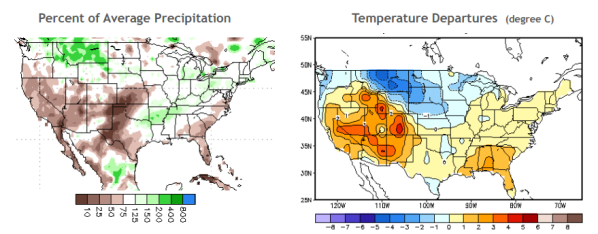
(Temperatures have tended to remain above average across most of the U.S. this winter even as abnormally dry conditions impacted the Southwest. Image source: NOAA.)

Under human-caused climate change increasingly warm temperatures result in higher rates of evaporation from lakes and soils. This increases drought intensity for many locations around the world. In keeping with this longer-term trend, the winter of 2018 can still be characterized as both warmer and drier than normal for most of the U.S. But the overall drought pattern has shifted more toward the Central U.S. and away from the West Coast with the approach of spring.

Thursday, 14 September 2017

Darkening snow in the Arctic - a positive feedback giving rise to more warming

H/T to Sandra Tetnowski, via Facebook

Dark Snow


One picture is worth a thousand words!


I am unsure where this is photographed but it is somewhere in the Arctic.


Without Arctic Ice, the seas will absorb 93% of the suns heat. Hence, as we lose sea ice we gain warmer seas. Then, we will see stronger hurricanes, hence, climate warming. Stronger hurricanes in warmer water!

Tuesday, 15 March 2016

Deteriation of the ice by soot and other pollution in the Arctic

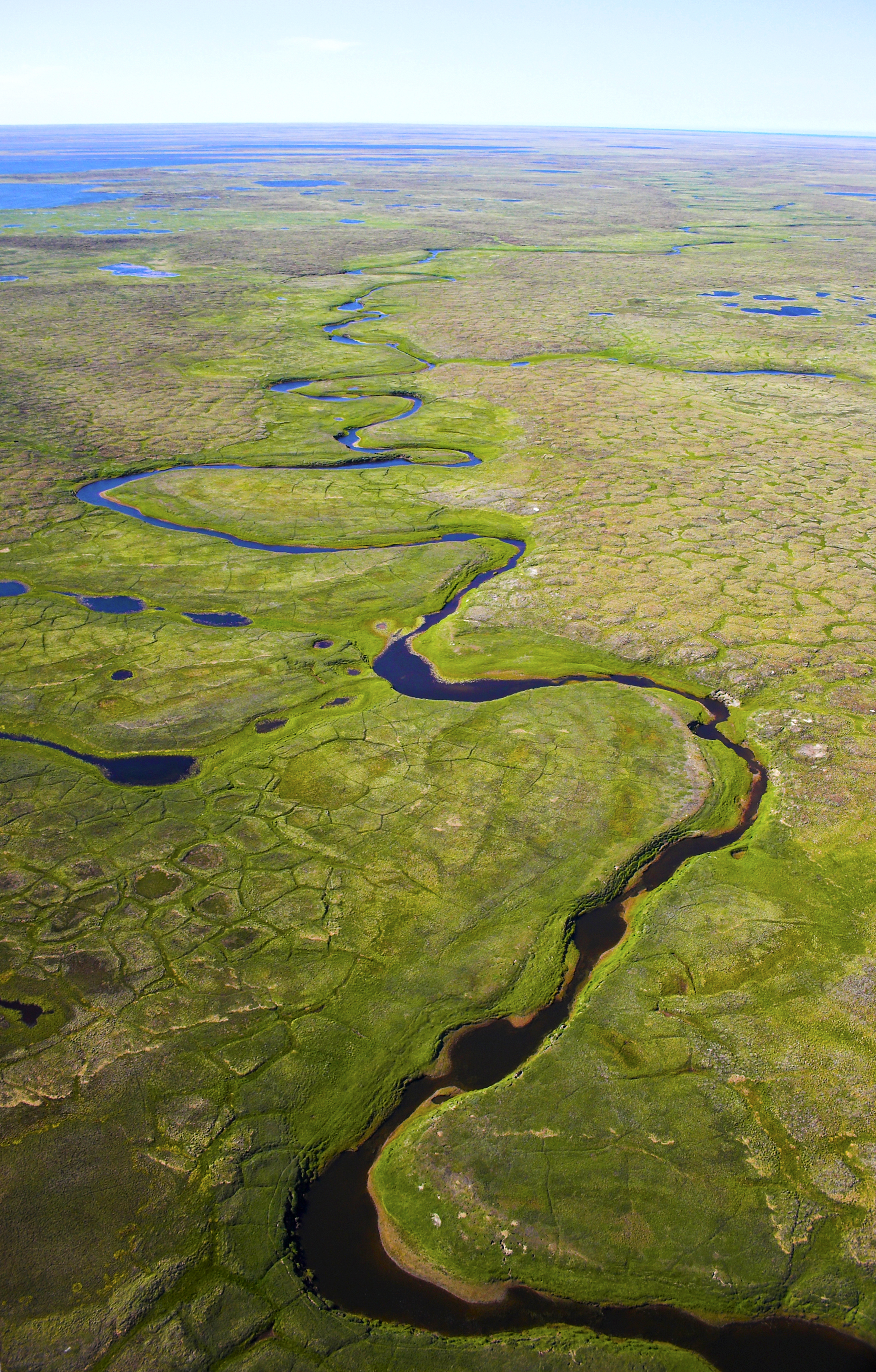
Degrading ice wedges reshape Arctic landscape


14 March, 2016

Ice wedges, a common subsurface feature in permafrost landscapes, appear to be rapidly melting throughout the Arctic, according to a new study published today in the journal Nature Geoscience.

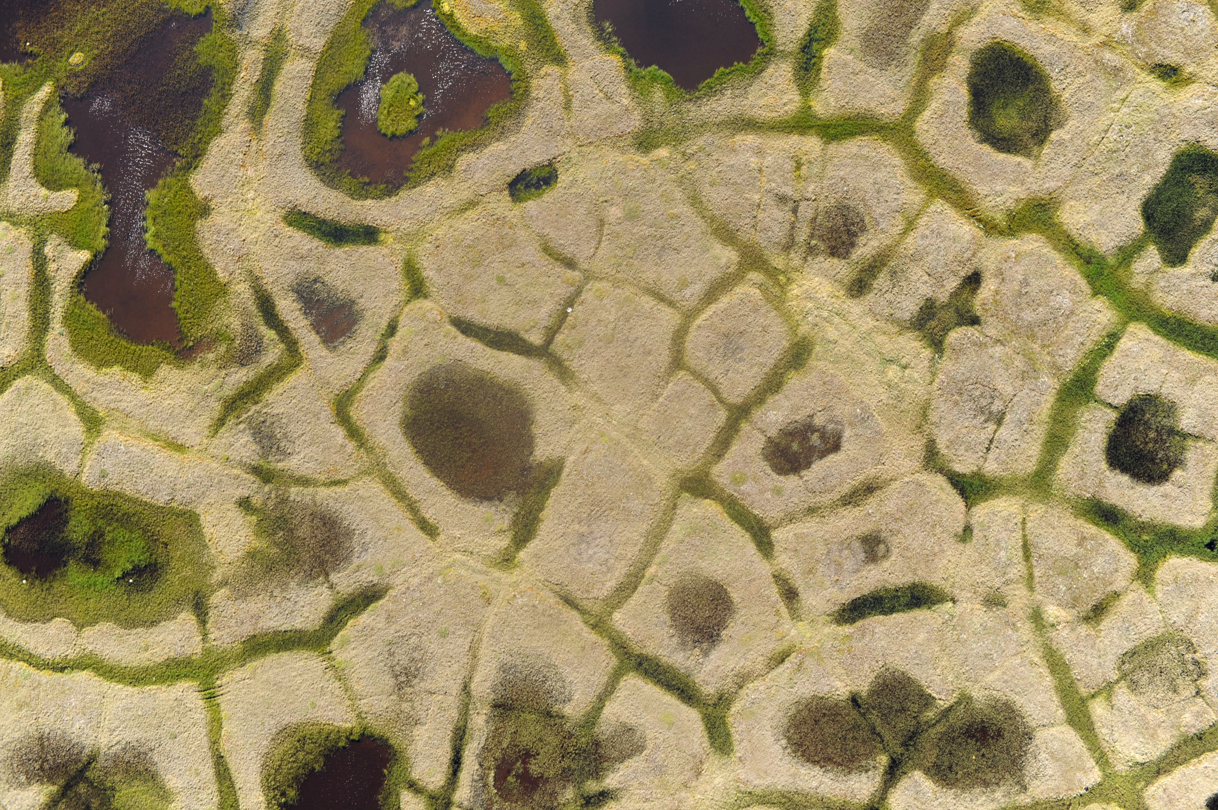
The wedges, which can be the size of a house, gradually formed over hundreds or even thousands of years as water seeped into permafrost cracks. On the ground surface, they form polygon shapes roughly 15-30 meters wide — a defining characteristic of northern landscapes.
Aerial photos of arctic tundra wetlands for backgrounds and textures
George Burba photo

Subsurface ice wedges often form polygon shapes in the Arctic landscape. A new study determines that the wedges are rapidly degrading, which could significantly affect the topography of many permafrost-rich areas.
The micro-topographic features of ice wedge polygons affect drainage, snow distribution and the general wetness or dryness of a landscape.
Anna Liljedahl, an assistant professor at the University of Alaska Fairbanks’ Water and Environmental Research Center, and her co-authors gathered information about the types of ice-wedge polygons and how they changed over time across the Arctic. They collected the information while performing various other permafrost studies.
Although these regions contain “cold permafrost,” with an overall average temperature of about 7 degrees Fahrenheit, surface thawing still occurred at all of the 10 study sites.
Ice wedge degradation has been observed before in individual locations, but this is the first study to determine that rapid melting has become widespread throughout the Arctic.
Here we’re combining observations from people working in the field across the Arctic — Russia, Canada and Alaska — where we’re seeing the same ice wedge melting phenomenon,” said Liljedahl, the lead author of the study.
Such thawing could bring significant changes to the hydrology of much of the Arctic as it alters the ground-surface topography. Melting of ice wedge tops makes the ground that surrounds the polygons subside, which in turn allows drainage of ice-wedge polygon centers. This can create a connective drainage system that encourages runoff and therefore an overall drying of the landscape.
It’s really the tipping point for the hydrology,” Liljedahl said. “Suddenly you’re draining the landscape and creating more runoff, even if the amount of precipitation remains the same. Instead of being absorbed by the tundra, the snowmelt water will run off into lakes and larger rivers. It really is a dramatic hydrologic change across the tundra landscape.”
A comprehensive satellite image survey hasn’t been done to determine how common polygon ice wedge patterns are in permafrost areas, but as much as two-thirds of the Arctic landscape is suited to their formation, Liljedahl said.
Gradual warming of permafrost has been well-documented in the Arctic, but the polygon study indicates that a brief period of unusual warmth can cause a rapid shift in a short time period.
JessieCherry_20726Jessica Cherry photo

Surface melting is causing changes in the hydrology of areas with ice wedge polygons, according to a newly published study in the journal Nature Geoscience.
At the sites that were studied, ice wedge degradation occurred in less than a decade. In some cases, a single unusually warm summer was enough to cause more than 10 centimeters of surface subsidence, enough to result in pooling and runoff in an otherwise relatively flat landscape.
Vladimir Romanovsky, a UAF geophysics professor who monitored ice wedge degradation for the study at a site in Canada, said the overall conclusions of the study were striking.
We were not expecting to see these dramatic changes,” he said. “We could see some other places where ice wedges were melting, but they were all related to surface disturbances, or it happened a long time ago. Whatever is happening, it’s something new for at least the last 60 years in the Arctic.”
Other contributors to the study include Julia Boike, Alfred Wegener Institute; Ronald P. Daanen, Alaska Department of Natural Resources; Alexander N. Fedorov, Melnikov Permafrost Institute; Gerald V. Frost, ABR Inc. Environmental Research and Services; Guido Grosse, Alfred Wegener Institute; Larry D. Hinzman, UAF; Yoshihiro Iijima, Japan Agency for Marine-Earth Science and Technology; Janet C. Jorgenson, U.S. Fish and Wildlife Service, Arctic National Wildlife Refuge; Nadya Matveyeva, Russian Academy of Sciences; Marius Necsoiu, Southwest Research Institute; Martha K. Raynolds, UAF; Jorg Schulla, Hyrdology Software Consulting; Ken D. Tape, UAF; Donald A. Walker, UAF; Cathy Wilson, Los Alamos National Laboratory; Hironori Yabuki, Japan Agency of Marine-Earth Science and Technology; and Donatella Zona, San Diego State University and University of Sheffield.
A press briefing will be held at 4 p.m. EST on Monday, March 14, in Room 104 of the Chapman Building at the University of Alaska Fairbanks and via live webcast at bit.ly/arcticnewsbriefing. Journalists accessing the briefing online will be able to ask questions via a chat window on the webcast page.

ADDITIONAL CONTACT: Anna Liljedahl, 907-474-1951, akliljedahl@alaska.edu

Further comment


Photo by cmbellas. Massive numbers of Cryoconite holes.


I don't think there has been anything in the history of the world that compares to what is happening now. The perferation and rate of deteriation of the ice by soot and other pollution is incredible (Harold Hensell, via Facebook)

Monday, 25 May 2015

Storm hits New Zealand

After an extremely long and warm summer abrupt climate change arrives in New Zealand with an unseasonably cold winter storm arriving in Autumn.This weather is neither normal nor expected.

#‎Thegreatunraveling‬ gathers pace for all to see who chose to look.


The heading is hyperbole but the storm is very large.

NZ hit by biggest storm on Earth

A storm blasting Antarctic weather over New Zealand is currently the biggest storm on earth according to WeatherWatch.


25 May, 2015

The low stretches from just south of Fiji to Antarctica's ice shelf, but only 20 per cent of the storm is affecting New Zealand.

Snow surrounding the Shotover River in Queenstown. Photo / Supplied Snow surrounding the Shotover River in Queenstown. Photo / Supplied

WeatherWatch.co.nz said the forecast air pressure at its centre over the next 24 hours would be greater than that of Hurricane Katrina when it made landfall in 2005.
Weather expert Philip Duncan said, "It's fairly normal to get a cold snap in late May. We're less than a week away from winter, it's not surprising to get a blast like this."END US YOUR WEATHER PICS AND VIDS
But he said the low's strength was surprising.

"The depth of this storm south of New Zealand is up there with some of the biggest hurricanes we've seen. It's a really big storm."


However, WeatherWatch.co.nz said only the storm's edges were affecting New Zealand - its centre lay around 1000 to 1500kms to our south east.


Southland, Otago and Banks Peninsula woke this morning to the heaviest dumping of snow so far this year.


Overnight, areas of Central Otago and Southland saw up to 30 cm of snow, according to Metservice.


The North Island didn't escape the cold weather with light snow falls reported in Napier and heavier falls on the Napier-Taupo Rd.


Queenstown Airport was temporarily closed, with heavy snow right down to the township, and snow flurries blanketed Invercargill.


Dunedin was battered by an onslaught of nasty weather, said MetService, hit by snow, showers and offshore thunderstorms.

Arrowtown blanketed in snow. Photo / Supplied by Petra BalsillieArrowtown blanketed in snow. Photo / Supplied by Petra Balsillie

15 cm of snow was reported just above the city, while its hill suburbs saw around 10 cm.
Mr Duncan said the South Island low had joined forces with the subtropical low that affected the North Island on Saturday.
"The two of them are working together to dredge up Antarctic air.
"So we've got this air at the moment being pulled up from Antarctica, and dumped over New Zealand."
There were a number of road closures for eastern parts of the South Island, with drivers advised to use extreme caution and to drive to the conditions.
MetService said while it was a cold morning, nowhere reached a record low for May.
Winter's icy grip took hold in the North Island as well, with snow reported down to sea level in Hawke's Bay.
Light snow falls were reported in the Napier suburbs of Taradale and Maraenui, and motorists experienced sleet on the way to work between Hastings and Napier.
A farm at Puketapu, Hawkes Bay. Photo / Supplied by Brenda Reay


Heavier falls were experienced inland, on the Napier-Taupo Rd and further north at Waikoau and Putere,
Cold southwest winds continued to bring showers across Auckland, and saw a severe weather warning put in place for Wairarapa and western Bay of Plenty where there was a risk of gales.
Last night's lightening storm and strong winds in Dunedin cut electricity to Musselburgh, Port Chalmers and part of the Otago Peninsula.
Aurora Energy said lightening damaged transformers, while severe winds brought down a power line.
Central Otago and Wanaka also experienced black outs.
Delta crews were responding to faults and making repairs as soon as it was possible to do so safely.
Overnight wind and rain and this morning's brief snow in Hawke's Bay resulted in power cuts in some "higher-up" rural areas.
Unison Networks customer relations manager Danny Gough said "a few hundred" customers had their supply cut, in some cases for up to two hours.
Temperatures were expected to rise slightly tomorrow, with warm weather set to return by Friday.
Meteorologist Georgina Griffiths said, "On Thursday morning, expect frosts across many parts of the North Island, as wind drops out, leaving the cold air behind."
The minimum temperature forecast for Thursday is 6C for Auckland, Tauranga and Wellington, 3C for Napier, 1C Palmerston North and 0C for Hamilton, Taupo and Masterton.


Snow no respite for drought afflicted farmers

25 May, 2015

Snow at this time of the year isn't unusual in southern regions, but brings extra challenges for South Island farmers still battling the effects of the summer drought.

The latest cold snap dumped snow through Otago and Southland as well as other parts of the country.

Andrew Paterson, from Matakanui Station, north of Alexandra in Central Otago, said they had had about five centimetres of snow there, and the onset of cold weather meant little chance to recover from the driest summer on record for his farm.

"We looked back on our rainfall records this year and for the last 12 month period to the end of May, we've had 12 inches (about 300 millimetres) of rain, which is the driest since we've recorded rainfall, since 1948. So, that's about an inch a month. We've only had five inches (about 130 millimetres) so far, this year."

Mr Paterson said it had given farmers there very little respite.

"We've gone from the end of a very dry season. We didn't even have any significant late rains in the Manuherikia and Ida Valley to push things along at the end of the growing season and now that this cold's come, we will wind up with some fairly severe frosts from now on and there will be little chance of any growth.

"So, what silage and hay and grain we've got will have to get us through."

In contrast, farmers in northern Southland were heading into winter comparatively well set up, after a benevolent summer.

Philip Tayler, at Lorne Peak, near Gaston, says the 10 to 12 centimetres of snow they had had there would not be causing them any big problems.

"We would never worry too much about May snow, because there's a saying that May snow never stays.


"Being in May all our breeding areas are down on the lower altitude country because the rams are out, another 10 days they will moving back out onto the higher altitutde stuff so that's when you're probably more vulnerable to snow."


Thursday, 20 November 2014

Snowstorm in New York

Second Round of Lake-Effect Snow to Bury Upstate New York Further

19 November, 2014

After a pause in the lake-effect snow on Wednesday, more bands of heavy snow will set up downwind of the Great Lakes, including northern and western upstate New York, later this week.

A weak disturbance that passed over the Great Lakes on Wednesday brought a general light snowfall to the region, but caused a lull heavy lake-effect snow.

However, lake-effect snow will re-energize Wednesday night into Thursday and will continue into Friday. Areas that will be hit by heavy snow include western New York, the Tug Hill Plateau of New York and western and northern Michigan.

Some areas that were hit with 3-6 feet of snow on Tuesday will soon be blanketed with another 1-2 feet of snow with locally higher amounts.
The redevelopment of these intense snow bands will mean more dangerous conditions and travel restrictions through the end of the week.

According to AccuWeather Chief Meteorologist Elliot Abrams, "While the second round of lake-effect snow may be not be as long-lasting, nor as intense, winds may be much stronger this time."
The combination of low temperatures, wind, snow and other atmospheric conditions will send AccuWeather.com RealFeel® temperatures to near zero F at times.

Even in areas where snow removal has taken place, intersections may be dangerous due to the high piles of snow at the corners and along sides of roads
.

Total snowfall from lake effect this week may top 8 feet in some areas south of Buffalo, with mountainous drifts. Some drifts may reach the top of one and two story buildings.

Due to the magnitude of the prior snow, some roads, streets and parking lots may not be cleared for days. The snow may have to be trucked away and dumped, which can be a slow process.

The risk of snow will to come to an end as the weekend arrives. Warmer winds from the south will send temperatures into the 50s and 60s, as a rainstorm approaches. However, new risks will arise.

According to AccuWeather Meteorologist Evan Duffy, "The combination of the warmth and rain will bring tremendous snow melt."

"Flooding will certainly be a concern."

Home owners should be on alert as basements may take on water from the quickly melting snow. Water may pool on streets and roadways, due to blocked storm drains.

On flat roofs, as the snow gains weight from the rain and drains remained blocked, there will be an increasing risk of roof collapses.

Property owners may want to move some of the snow off roofs, if it can be done safely.

New York snowstorm kills at least five as freezing temperatures grip US

Storm blamed for at least five deaths in New York, New Hampshire and Michigan as temperatures plunge


19 November, 2014


A brutal storm of ice, snow and record cold temperatures has killed at least five people near Buffalo, New York, as a system of freezing temperatures and heavy precipitation swept toward the US east coast.

The early snowfall heaped five feet of snow in some areas, trapping cars, buses and plows in heavy drifts. Snow totals could exceed 6ft by the end of Wednesday – with another storm expected on Thursday.

Response teams in western New York, accustomed to harsh winters, were surprised by the unusually early and heavy precipitation. Schools closed as New York governor Andrew Cuomo declared a state of emergency in several counties and has 150 members of the state national guard and extra teams of snow plows.

High winds have exacerbated conditions, and temperatures dropped below 
freezing across most of the US, with subzero temperatures in Illinois, Wisconsin and Nebraska, where a teenager died from exposure. In the Buffalo area, two people shoveling snow during the storm died of heart attacks, a third was pinned beneath a car while trying to free it, a fourth found inside his car, and a fifth also suffered a heart attack.

snow
Firefighters help a stranded motorist in Depew, New York. Photograph: Derek Gee/AP

Snow drifts and ice have paralyzed more than 150 vehicles on on more than 100 miles of roadway, including the Niagara University women’s basketball team, trapped on board their bus for more than 24 hours. The team coach told the Associated Press that players were so thirsty they drank melted snow. Traffic accidents blamed on icy conditions have killed more than a dozen people.

Weather experts blame a phenomenon called the lake effect for the exceptionally intense storm; cold winds pick up the warm, moist air over lakes, freezing it as it travels before dumping it suddenly when those winds reach land. Nestled on Lake Erie’s shores and not far from Lake Ontario, Buffalo was struck by a curiosity of the effect – snow buried its southern suburbs but barely dusted its northern outskirts.
The huge system dropped as much of 18 inches in Michigan, shut down schools in North Carolina and Pennsylvania, and forced roads closed in Indiana, New Hampshire and around the US. Cities in Alaska may be warmer than towns in northern Florida on Wednesday if temperatures rise as expected. Through Friday, Buffalo will have to soldier through two separate lake effect warnings, and possibly as much as two more feet of snow as storm bands sweep in.


Amazing photo from Chrissy Gritzke Hazard in Cheektowaga, NY where the weight of the snow is so much it is beginning to collapse roofs and break through doors like this picture shows. Historic snow for that area....some are closing in on 60-70 inches! After a break for some of the hardest hit areas today, another 1-2 feet is possible tomorrow as the lake effect snow band shifts again


The whole situation


Monday, 17 February 2014

Slovenia

An insane amount of snow in Slovenia


430 cm of snow as of this morning on Kredarica (2514 m), Mt. Triglav, Julian Alps, NW Slovenia. Expecting more later today and tomorrow.


Source: ARSO (Slovenian Environmental Agency).

Sunday, 16 February 2014

Climate chaos in Australia

Weather: From 40-plus degrees to chance of snow
Victoria has had fires, 40-plus degrees and the rain is beginning to pelt over the state's north-west, but by Thursday next week we could have snow


SMH,
14 Febraury, 2013

No, this is not a misprint.

Bureau of Meteorology senior forecaster Scott Williams said Victoria's heatwave had been "flushed away" by a cold front coming from South Australia. And, although we might get another heat spell in March, by Wednesday or Thursday next week there may be "snow flurries" in the alpine areas.

Mr Williams said the meagre high of about 21 degrees in Melbourne on Wednesday and Thursday could even be revised down.

"When the cold air goes over us on Wednesday and Thursday... we might struggle to get to 20," Mr Williams said.

He said rain had begun to fall over the north-west of the state and was heaviest in the far north-west. Ouyen had 18 millimetres over the 24-hour period to Friday 9am.

Mr Williams said the hourly rain figures for Mildura - which had eight days over 40 degrees in the first half of February – were unavailable due to a faulty electrical rain gauge. But the bush telegraph had kicked in, with locals calling the bureau with statistics from their home rain gauges. He said an old-style "eight-inch" gauge would provide a rain measure at 9am and 3pm on Friday. In the 24 hours to 9am Friday, Mildura had 16 millimetres of rain.

On Friday afternoon, heavy rainfall and the cold front are expected to push through the northern Mallee area, bringing 60 millimetres, with isolated totals of 100 millimetres. The southern Mallee is expected to get about half of that rain, with 30 millimetres and isolated totals of 50 millimetres. Not much rain is expected in the Wimmera and to the south.

A low pressure trough is expected to push through to fire-ravaged Kilmore and Gippsland, and to Melbourne, on Saturday, with 5-10 millimetres of rain expected on Saturday night.

Mr Williams said the cooler conditions on Wednesday and Thursday were expected to bring up to 20 millimetres of rain to Kilmore and Gippsland.

"There is not going to be a knock-out blow for the fires but it is going to be death by a thousand cuts with the rain and cooler temperatures," Mr Williams said.

"We won't be in a position that [the fires] will be all put out, but they will be aided," he said.

Mr Williams said the intense Victorian heatwave had lasted two to three weeks, which was longer than usual. He said it was possible there could be a further heatwave in March but there had only ever been eight days over 40 degrees recorded in history.

Weatherzone meteorologist Rob Sharpe said while Mildura normally had five days over 40 degrees and this year had 20, Rutherglen - a town with an average of two days over 40 - has had 15 days over 40 degrees.

Mr Sharpe said there was a chance that the north of the state might get another round of hot weather in the high 30s on February 24 or 25.

According to Mr Williams it is "pretty unlikely" we will have another heatwave of the same intensity as the one we have just had, but he said there could be another warm spell in March.

He said March, the beginning of autumn, saw shorter days and less chance for the sun to push temperatures up. All recorded days over 40 degrees in Melbourne were before March 12.


Canberra plans for a wet and wild weekend


14 Febraury, 2013

Canberra will be getting wet and wild over the weekend, with the territory's first significant summer rainfall failing to dampen plans for a number of big weekend events.

Between 20mm to 40mm of rainfall has been forecast for the Canberra region over the weekend, almost as much as has fallen over the entire summer season so far.

The ACT had just 29.8mm of rainfall in December, January and February, well below the 165mm average for the season....[ ]


Friday, 14 February 2014

Snowstorm hits the South and the Northeast

Catastrophic snow storm strikes northeast US, after causing icy chaos in south


SMH,
14 February, 2014


Atlanta: A thick layer of ice covered much of the deep south on Thursday and most of the cities of the south from Birmingham to Myrtle Beach were still locked down from a large winter storm that was moving up the east coast.

At least 800,000 customers in the south are without power, 344,000 in Georgia alone, and at least 12 deaths have been attributed to the weather.
Joey Picca, a meteorologist at the National Weather Service, said the impact of the storm was widespread.


More snow than Sochi ... A lone cross country skier braves the cold and snow to ski near the US Capitol Building in Washington.

It is a storm that has brought wide-ranging effects, from heavy snow and ice to severe weather, including strong winds and hail, down south,” said Mr. Picca.
After battering the south, the storm dumped more than 30cm of snow in some parts of the mid-Atlantic region, bringing the threat of more power failures and widespread closures. Federal offices in Washington were closed on Thursday.


Air and train travel remained nearly impossible in most southern cities and airports along the east coast were also affected. In all, more than 4800 flights had been canceled on Thursday, according to FlightAware, which tracks airline flights. At least 2300 flights have been canceled at the Hartsfield-Jackson airport in 
Atlanta, 800 of them on Thursday.


Clearing the roads ... A snow plow knocks snow off an Atlanta expressway during an ice storm in Georgia.


By morning rush hour, New York City was blanketed in white. A steady snowfall gathered in intensity as the morning wore on, with blizzard-like conditions in some parts of the city. Still, while millions of schoolchildren in the storm’s path were given the day off, New York City public schools remained open.


For residents of the northeast, the storm was just the latest to come through in a particularly harsh winter. Residents in South, however, were shocked to see snow accumulations in the double digits, something that had not happened for 26 years.
Augusta, Georgia on Thursday was coated with 2.5cm of ice, Charlotte, S.C., had 15cm of snow, and Atlantans woke up to soft flakes falling over the layer of ice left from the day before. The city has been essentially closed for three days now, waiting for a weekend that promises 15-degree Celsius temperatures.


Citibikes are parked in a base station during a morning snow storm in New York's financial district.

Unlike Raleigh, North Carolina, Atlanta had learned its lesson. Two weeks ago, interstates in the Atlanta metro area were clogged with drivers who all seemed to leave their offices and schools at the same time as a midafternoon snow and ice storm hit. Some people spent more than 20 hours in the car trying to get home.
On Wednesday, although the storm warnings had been early and plentiful, Raleigh looked like a smaller repeat of Atlanta’s experience.


Some schools were canceled but residents who went to work on Wednesday poured onto Raleigh’s roads and freeways as the snow started around noon. By 3 pm, there was gridlock. Cars were abandoned as people tried to get home on foot, including Sarah Cengel. Six months pregnant and with a coat that she could not close because of the size of her belly, she walked through the snow for three hours after her car got stuck.


Traffic chaos ... abandoned cars on I-75 are piled up in the median of the ice-covered highway after huge snow storm in Atlanta.

In Wake County, North Carolina, the local authorities and members of the National Guard searched abandoned vehicles for occupants.


We’ve gotten a couple of folks who were stranded, and we safely have taken them to area shelters,” said Eric Curry, a spokesman for the county said on Thursday. And as daybreak emerged in North Carolina, Mr. Curry said, drivers were already trying to locate their vehicles.

We have a number of cars — not the magnitude of Atlanta — but there are cars that motorists abandoned yesterday, and they are starting to retrieve them,” he said.

In Jackson Heights, Queens, Ranjit Roy, who works at a gas station, began pushing snow with a sturdy, two-handled shovel just after midnight. But nearly as soon as he had an area clear, it was covered back up.

Every half-hour, I do this, every time I’m done I have to start again,” Mr. Roy, 54, said early on Thursday.

In New Jersey, Governor Chris Christie declared a state of emergency and urged caution.

I encourage all New Jerseyans to drive carefully and remain off the roads if possible so that our first responders and public safety officials can safely respond to any emergency situations,” he said in a statement.


US weather Snowstorm shuts down Washington DC