Showing posts with label blizzard. Show all posts

Wednesday, 30 January 2019

Conditions in Northern Hemisphere

Extreme Cold Still Forecast To Overspread US Wed-Thurs while Arctic Ocean Basin Warms

30 January, 2019

An extremely cold Arctic air mass continues to spill out of Canada and into the US today. This is the result of a very wavy jet stream, promoting a powerful surface high pressure system to plummet southward; and with it, the intense Arctic cold, typically normal to northern Canada. The worst impacts from this cold will be Wednesday and Thursday. Wednesday morning will feature wind chills as cold as 50-60 below, with potential for isolated values down to 70 below in northern Minnesota into the Dakotas. 
For human health, it's the apparent temperature which is meaningful. And a significant sector of the country will see wind chill values near 0 F/-18 C overnight Tuesday/Wednesday. Wind chills capable of causing frostbite to exposed skin within 5 mins of exposure...generally -50 F/-46 C...will be possible across a wide swath of the northern Midwest and northern Plains. 

Of course, while this disrupted polar vortex puts much of the eastern half of the US and Canada in the deep freeze, the Arctic Ocean Basin is undergoing warming. Abrupt climate change is accelerating the warming of the Arctic. This is allowing for major disruptions of the tropospheric polar vortex in the winter months, with the jet stream becoming extremely wavy with pronounced dips into the mid-latitudes. The result are intense, anomalous cold events in a couple of regions of the Northern Hemisphere, while most other places experience anomalous warmth; including the Arctic Basin, as intense upper-atmospheric high pressure systems and warm ocean storms move over the region.
Anomalously warm temperatures forecast over the next 7-days in the Arctic Ocean Basin. ~2.8 C average over the Basin relative to pre-industrial times. Also note the extreme cold anomaly over northern Siberia.

Air temperatures (above) and temperature anomalies (below) for 6 UTC Thursday (midnight CST Thursday). Cold anomalies of 20 degrees C below normal over parts of north-central Siberia with anomalies of 14-18 C above normal near the Kara and Laptev Seas! A cyclone is forecast to move over the Arctic Ocean, drawing in warm air from the Atlantic during this time.

The increasing winter time Arctic "heatwaves" with cold air pouring out into the mid-latitudes represents the long-term destruction of the Arctic air mass keeping the high-latitudes cold. As the Arctic warms, the temperature gradient with the mid-latitudes decreases. This causes the jet stream to slow, increasing its waviness. The waviness both forces more cold air out of the Arctic, replacing it with warmer air from the mid-latitudes. This is a feedback loop toward destroying Arctic cold, reinforced by long-term global warming. 

So while these intense Arctic blasts may remind many of the typical cold winters of the past, the frequency of the blasts and the tendency in many places toward increasingly huge swings between very abnormal warmth and then cold and back again, means more chaotic seasonal conditions. This poses hazards for not only human health, but the health and biological patterns of other organisms as well as agriculture at the beginning and end of growing seasons. 
---Meteorologist Nick Humphrey


A wave of extremely cold air has descended upon Wisconsin, and a State of Emergency has been declared for this week.
Wisconsin Colder Than Antarctica, State Of Emergency Declared
Wednesday morning is forecast to be our biggest chill. Morning lows will be from -20 to -30 degrees with afternoon highs from -10 to -17 degrees. The record low temperature in Milwaukee is -24 and was set 1951. According to historical data from the National Weather Service, the record minimum wind chill at Milwaukee is -56 was set on Jan. 10, 1982.
State of Emergency Declared
This week, Wisconsin Gov. Tony Evers declared a State of Emergency in Wisconsin for Jan. 27 through Feb. 1. In the emergency declaration, Evers cited extreme temperatures and dangerous travel conditions.
The State of Emergency gives state officials the option to deploy the Wisconsin National Guard to assist local authorities with emergency response and recovery needs throughout the state via the Wisconsin Emergency Management division.

Tuesday, 26 January 2016

Extreme conditions across the globe


Deaths in Japan and Taiwan as record cold snap hits east Asia

At least 95 people die as record-low temperatures in region bring snow and ice cause flight cancellations and leave thousands stranded


25 January, 2016

Snow, sleet and icy winds across east Asia have caused deaths, flight cancellations and chaos as the region struggles with record-low temperatures due to an Arctic cold snap that brought snow to several tropical areas for the first time in many people’s lifetimes.

In Taiwan, the capital Taipei recorded a low of 4C (39F), the coldest in 44 years. Local media said 90 people had died due to the cold weather, mainly from hypothermia and cardiac arrest. Five more died in Japan.

Hundreds of flights were cancelled across the region, tens of thousands of holidaymakers were stranded in South Korea, and freezing conditions in sub-tropical Hong Kong caused mayhem on its tallest peak.

In northern Vietnam, snow blanketed mountain areas as the wave of cold air arrived on Sunday to Lào Cai province. In the capital, Hanoi, it dropped to a milder 6C, although authorities said that was the coldest the city has been for two decades.

The southern Chinese city of Guangzhou, which is by the tropic of Cancer, saw sleet for the first time in 60 years, the local meteorological station said. Residents posted photos online of small snowmen they had made, quickly constructed from a thin layer of icy flakes that fell on cars and road.

A Guangzhou driver, Wang Jun, told the South China Morning Post that he had never seen sleet throughout his 20 years working in the city. “I woke up at 6am to work and saw small pieces of ice hit my windscreen. It stopped for a while, but happened again half an hour later. And then there was sleet at about 11am,” he said.

“It’s the first time I’ve see that. It’s very beautiful,” he said.

The cold was caused by a polar vortex, a large cyclone that pushed south from Siberia and unusual meteorological occurrence for east Asia.

In Hong Kong, primary schools and kindergartens were closed on Monday after temperatures fell to 3C, a 60-year low. A 100km ultra-marathon race was abandoned as competitors crossing the city’s tallest peak, Tai Mo Shan, slipped on icy slopes buffeted by freezing winds. A race official described the scene as one of “carnage”, with dozens of people suffering from hypothermia; firefighters called in to rescue them were filmed slipping and sliding on the icy road.

In Bangkok, labelled the planet’s hottest city by the World Meteorological Organisation for its mean air temperature of 28C, the mercury dropped to 16C on Monday. Scarves and padded jackets, normally bought only as winter holiday items by residents of Bangkok, appeared in the city as locals dealt with the unusually cool weather.

During the peak tourism season, the sea in many areas was dark and rough as grey clouds hung overhead.

Hundreds of flight cancellations left tens of thousands of holidaymakers stranded in South Korea, after the biggest snowfall in three decades shut the airport on the resort island on Jeju.

In China, 24 weather stations recorded all-time low temperatures. Further north, in Inner Mongolia, the temperature dropped to a record low of -46.8C (-52F) and in China’s eastern city of Qingdao, fishing boats were stuck fast in the frozen waters.

The weather ruined many people’s travel plans for the Chinese lunar new year season, when families normally travel to their home towns.


If you never read any science, or if you're a complete idiot, you might think this was "evidence" of a coming ice age.

Never mind the fact that it's raining and temperatures are 55F higher than what they should be.

Perhaps all the evidence is being fabricated. Lol.


But if you're open to looking at  things rationally and open to a  bit of science, paul Beckwith can put it into context

Arctic Ocean Blowtorch Attacks Sea-Ice

Our climate system has destabilized. Our fossil-fueled emissions have changed the chemistry of our atmosphere and our oceans, changing the heat balance between the equator and Arctic. This has fractured the jet streams, and brings us closer to a new planet with zero snow and ice in the Arctic. Here is what is happening...


Or this...

Blizzard Jonas and the slowdown of the Gulf Stream System


Blizzard Jonas on the US east coast has just shattered snowfall records. Both weather forecasters and climate experts have linked the high snowfall amounts to the exceptionally warm sea surface temperatures off the east coast. In this post I will examine a related question: why are sea surface temperatures so high there, as shown in the snapshot from Climate Reanalyzer below?


Or this... From Jason Box

'If anything, climate sensitivity is higher'-Glaciologist Jason Box on climate sensitivity


Back to the news stories


As Hong Kong emerged into the crisp sunny day today after its record-setting cold snap on Sunday areas around the world were experiencing unseasonal weather. 

In Melbourne, Australia summer’s extreme heat gave way to relatively cold weather, as the United States dealt with record snowfall in a blizzard. Even New Delhi in India battled through a wave of cold weather; the minimum temperature in the often steamy city was just 4.2 degrees Celsius on Friday, below


Japan snowstormTOKYO, Jan. 24 (Xinhua) — Five people died and scores have been injured, as swathes of western and central Japan on Sunday saw record amounts of heavy snowfall blanket town and cities.


The snow caused major disruption to transportation networks, with hundreds of flights canceled and bullet trains services suspended. Conditions are likely to worsen

Polar vortex hits Hong Kong: new records as temperatures plummet towards zero, weather bureau promises more cold to come


Blizzard and hurricane winds kill 19 people in north-eastern US states


Some were killed in car accidents, three died shovelling snow in New York City and two of hypothermia in Virginia


While the el-Nino is live and well in the Pacific....


Sunday, 24 January 2016

Climate- change- fueled blizzard hits US eastern states

Blizzard Fueled By Ocean Heat Cripples Eastern US, Floods Coast With Historic Storm Surge


A bulldozer clears snow on the East Front of the U.S. Capitol January 23, 2016 in Washington, DC. Alex Wong / Getty Images / AFP

23 January, 2016

We knew the weather this weekend would be wicked. A predicted extreme winter storm kicked into a much higher gear by an atmosphere warmed by human greenhouse gas emissions and by a record heat and moisture bleed coming off an anomalously hot Atlantic Ocean kind of wicked. A severe Blizzard featuring 12-40 inch snows, near record to record storm surges, and hurricane force wind gusts that has been showing up in model forecasts since earlier this week. And it appears that’s exactly what we’re getting.

Heavy Snows Cause Major Disruptions

Jonas Saturday Morning
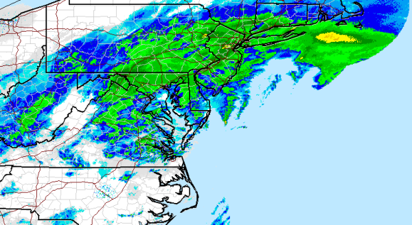
(National Weather Service Radar showing heavy snowfall stretching from West Virginia to Rhode Island at 10:45 AM Saturday Morning.)

By early Saturday morning, the reports were coming in. More than 1,500 vehicles were wrecked or disabled along Virgina State highways Friday evening as the storm roared across the region. Sudden, heavy snowfall generated a similar snarl — setting off a 40 mile long traffic jam in Kentucky which stranded motorists for more than 12 hours. According to reports from The Weather Channel, Jonas had already dumped as much as 28 inches of snow by 8 AM this morning. With 5-20 more inches on the way for many regions, these totals are expected to continue to climb.

These crippling snowfall totals were hitting very close to home in Gaithersburg, MD — where I took this video of still heavy snows over an already amazing 21 inch accumulation (unofficial).

The video was taken during a lull in an area that’s been experiencing accumulations at faster than 1 inch per hour rates since late last night. Sporadic reports of thundersnow were also starting to trickle in — especially in areas closer to the Chesapeake Bay like Baltimore


Severe Coastal Flooding Threat Grows

Along the coast, Jonas’s impacts began to look more like those of Superstorm Sandy than of a typical winter snowmaker. Winds on the Eastern Shore of Virginia hit a peak hurricane force gust of 85 miles per hour earlier this morning as Jonas gorged on record warm Atlantic Ocean waters and intensified. These strong winds combined with astronomical high tides and a climate change related pile up of Gulf Stream waters off the US East Coast to push tides to the second highest level on record for Delaware beaches.
On Saturday morning, the water level at Lewes, Delaware, rose to 9.27 feet, a storm surge of more than 4 feet. This is the highest level on record at that gauge, beating 9.20 feet on March 6, 1962. Record flooding has also been observed in at least three New Jersey locations (Great Channel at Stone Harbor, Cape May Harbor, Delaware Bay at Cape May).
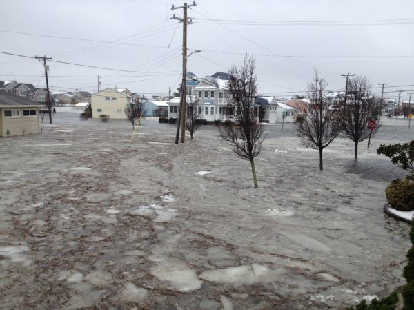
Cindy Nevitt in Cape May, New Jersey sent along this photo of ocean floodwaters and ice floes surging around her coastal home this morning as Jonas mercilessly drove its surge inland:

Cindy Nevitt Cape May New Jersey
(Severe coastal flooding surges into Cape May New Jersey as hurricane force gusts drive a storm surge into the Northeast Coast on Saturday morning. Image source: Cindy Nevitt.)

Reports are beginning to come in of ongoing emergency evacuations of coastal homes flooded by surging waters in this region. Given the 9 foot above normal tides combined with hurricane force wind gusts and 30 foot waves slamming into beaches, sand dunes and sea walls, it’s a situation that is, sadly, likely to worsen as the day progresses.
Many of the Worst Impacts Still to Come

To this point, it’s important to note that, with Jonas still centered off the Delmarva Peninsula, this major tidal flooding that regions are now currently experiencing is just the start. The head of water should continue to build on into late Saturday as it moves up the coastline and into New York City, Long Island, Coastal Connecticut, Rhode Island and Massachusetts. Furthermore, impacts to New Jersey and Delaware should remain dangerous or worsen over the coming hours as winds pile waves and waters on top of already record high tides.
Meanwhile, Jonas will continue to generate heavy snowfall over hundreds of miles on into Saturday evening. The situation, therefore, remains quite dangerous and all residents in the affected areas should keep tuned to local emergency officials for instruction. In other words, this climate change enhanced monster winter storm isn’t done yet. Not by a long shot.
Links:
Hat Tip to DT Lange
Hat Tip to Colorado Bob
Hat Tip to Greg

Raw: Times Square Nearly Blotted Out By Snow


Saturday, 23 January 2016

Nightmare Storm for US East Coast

Going, going...gone are the days (such as at the time of super storm Sandy) that I could devote time and energy to chronicling the details of extreme weather events. They are simply too frequent and there are so many other things that demand my energy, so this report from Robertscribbler will suffice for now

A Blizzard Roars Out of Climate Change’s Heart — Polar Warming and A Record Hot Atlantic Ocean Brew Up Nightmare Storm for US East Coast


21 January, 2016

There’s a historic blizzard in the form of Winter Storm Jonas setting its sights on the US East Coast. The storm is slowly coming together Thursday evening and now appears to be set to paralyze a 1,000 mile swath under 1 to 2.5 feet of snow even as it hurls a substantial storm surge and 40-60 mph winds at waterfront cities from Norfolk to Boston. A monster storm whose predicted formation has made headlines since Tuesday. But what you won’t hear most major news sources mention is the likelihood that this gathering storm has been dramatically impacted by a number of new climate features related to a human-forced warming of the globe.

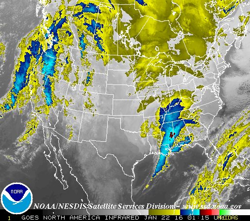
Jonas Begins its Ocean-heat Fueled Rampage in Southeastern US
(Jonas begins its ocean-heat-fueled rampage on the evening of Thursday, January 21. Image source: NOAA.)

A Warming Arctic Shoves the Cold Air Out

To understand how climate change helped make Jonas so extreme, it’s best if we start our tale in the Arctic. For if we could mark an area on the Earth’s surface that is at the very heart of impacts for human-caused climate change it would be in that zone of the far north above the 66th parallel. It is there that we see the most dramatic, most rapid changes — to ice, to weather, to the thawing lands, to life itself. But unlike what might be said of an American city made famous by its penchant for sin — what happens in the Arctic doesn’t stay in the Arctic.
This is especially true when it comes to weather. If the Arctic cools, it influences the Jet Stream, strengthens the storm track and shuts more cold air away in the Arctic. But if the Arctic warms, as it has more and more frequently during recent years, then the flood-gates open and cold, Arctic air pours outward — filling the deep, inevitable dips in the Jet Stream that then develop.

And it is a massive accumulation of Arctic heat over the past few weeks that has forced Arctic temperatures, in places, to rocket to above 36 degrees Fahrenheit (20 degrees C) warmer than average. A heating up of the entire region to 2-3 degrees Celsius warmer than the already warmer than average 1979- 2000 baseline. An Arctic warm-up that muscled out a howling torrent of cold air that then raged on into a deep trough in the Jet Stream now forming over the eastern half of the United States.
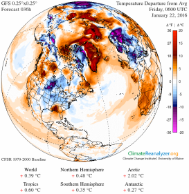
Hot Arctic, Cold, Stormy Eastern USMangled Jet Stream, Raging Storm Track
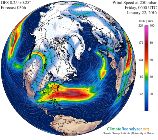
(An Arctic that is, on average 2.02 C hotter than normal on Friday joins with a high amplitude wave in the Jet Stream and together drives a massive flood of cold air into eastern parts of the US on Friday. Cold air slamming head on into unprecedented heat and moisture bleeding of the Atlantic Ocean to form the historic weather event that is now in the pipe. Image source: Climate Reanalyzer.)

CAPE — Storms Fueled by Cold Colliding With Hot

In weather parlance, a trough, or a big dip in the Jet Stream is a storm generation zone. The reason has to do with the nature of how extreme differences in temperature and moisture can provide fuel for strong storms. It’s this very temperature differential that sits as the cornerstone of our current understanding of how extreme storms are fueled in terms of Convective Available Potential Energy (CAPE).

In the one case, cold air can’t hold as much water in suspension as warm air. So a big flood of cold air can often fuel major precipitation events when coming into collision with hot, moisture-laden air. As hot and cold air are sandwiched closer together, winds — at both the upper and lower levels — tend to increase in velocity. The higher the difference in temperature, the stronger the winds. When these winds run along a big dip in the Jet Stream — like the one now racing over the US East Coast — they can spin off twists and vortexes that can rapidly develop into powerful low pressure systems.
The lows then feed on the difference in temperatures between the two sides of the dividing air-mass — cold on the one side, and hot, wet on the other. The bigger the differential, the more heat and moisture on one side, and the more cold on the other side, the more potential that such low pressure centers will develop into monster storms. The more potential that the storms will develop these crazy atmospheric sandwiches of hot and cold air that really crank out the extreme weather.
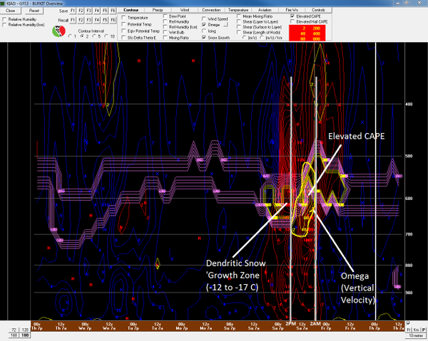
Dulles International Airport 5 inch per hour thundersnow potential identified
(“Tremendous Vertical Motion.” Anthony Sagliani tweets about extreme CAPE for a blizzard zeroing in on the US East Coast. What’s important to mention is that human-forced climate change has CAPE written all over it. Image source: Anthony Sagliani.)

In terms of the current storm, some of the CAPE potentials coming in are just off the charts. The above graphic, posted in this recent tweet by Anthony Sagliani, identifies the potential for 5 inch per hour thundersnow at Dulles International Airport (AID) between 2 AM and 2 PM Saturday. To be very clear, a 1 inch per hour snowfall was once considered an extreme event. Now we are looking at possibly 5!

A Record Hot Atlantic Feeds it All

In the context of human-driven climate change, this is one of the reasons why our warming up of the world can generate extreme weather. It warms the Earth unevenly. It puts cold next to hot by driving cold out of the polar zones and by warming up huge areas of land and ocean. And it dumps more moisture into the atmosphere through an amplified evaporation from these greatly warmed Earth surfaces. Mix it all together and you get Anthony Sagliani’s ‘tremendous vertical motion.’
How does this work? In two words — latent heat. More specifically the convective heat energy available in water vapor. And where does most of that latent heat energy come from? It comes, for the most part, in the form of warm waters evaporating into the air above the world’s oceans. More specifically to our current storm it comes in the form of record warm to near record warm temperatures in the waters of the Gulf Stream off the US East Coast (See Dr Jeff Master’s ‘The Future of Intense Winter Storms”).

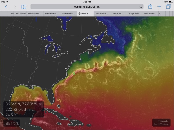
image
(Sea surface temperatures off the US East Coast are more comparable to those seen during Summer than what would be typical for January. A 76 degree sea surface off Norfolk will provide a massive amount of heat and moisture to fuel the new kind of storm that is Jonas. Image source: Earth Nullschool.)

As Dr. Michael Mann noted in a tweet earlier this week, sea surface temperatures off the US East Coast are extraordinarily warm for this time of year. And Bill McKibben was absolutely astute in saying that these near record temperatures “should turbo-charge this weekend’s blizzard.”

And they’re absolutely ridiculously warm — in the range of 76 degrees Fahrenheit in a region about 150 miles due east of Norfolk, Virginia. A region of ocean over which the developing storm center will directly cross. An area of water that is now in the range of 7 degrees Celsius above average (13 degrees Fahrenheit). For the ocean surface, this is screaming hot — more typical to summer than anything one would expect to see in January, even in the Gulf Stream.
You just don’t see these kinds of temperature departures for the ocean — or at least you didn’t before human-caused climate change started to ramp up. But now we have them — an ocean surface hot enough to support a hurricane but one that will this weekend provide fuel for a blizzard. So the kind of blizzard we will have will not at all be like even the usual blizzards of the 20th Century. This is the new, worse variety that will sadly become more frequent. Destructive, heavy snowfall in the 4-5 inches per hour range, thundersnow and storm surges combined, swaths of hundreds of miles impacted and crippled. The kind for the new age of a human-heated atmosphere — destabilized to produce freak storms of a ferocity and frequency the likes of which we have never seen.
UPDATE — Snowfall Begins With Some Models Showing 4 Feet or More Possible (Average Guidance For Gaithersburg is 24-30 Inches)


Moderate snowfall began at 1:35 PM on Friday in my hometown of Gaithersburg, MD. Model guidance for our area is in the range of 24-30 inches, with as much as 4 feet coming up in some of the GFS ensembles.
Will be posting videos and related updates every 2-3 hours as conditions change.
UPDATE: 1-2 Inches on the Ground at Gaithersburg, MD as of 3:42 PM


Wind and rates of snowfall have picked up somewhat over the past two hours. As of 3:42 PM, about 1-2 inches had fallen and the wind was visibly swaying some of the tree branches outside. Reports are coming in from regions to the south of a very heavy band of snow that should arrive in our area by later this evening.
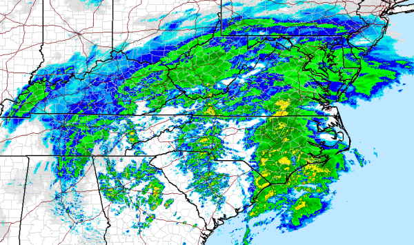
Radar captures by the National Weather Service indicate this band setting up over much of Central and Eastern North Carolina — stretching northward through just west of Richmond. GFS model tracking and satellite confirmation indicate a coastal low developing in the region of Northern South Carolina. This low is beginning to transfer Atlantic moisture into the storm — pulling strong winds off that abnormally warm region of ocean just east of Norfolk and into the developing powerful snowfall and.

Jonas 420 PM NWS Radar
(Image source: National Weather Service.)

Sustained winds along the coast are now approaching gale force.  We should expect these winds to rapidly increase over the afternoon and evening hours even as the moisture feed and rate of snowfall intensifies.
Links:
Hat Tip to DT Lange
Hat tip to Colorado Bob

Here is live coverage from the Guardian


  • Washington DC in bull’s eye of potentially record-breaking storm
  • Hundreds of vehicle crashes reported as storm moves through south
  • Coastal flood warnings and states of emergency in effect