Wildfires
Are Burning Some of the World’s Oldest Trees
27
January, 2016
More
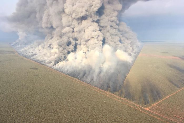
than 89,000 acres have burned since lightning ignited around 100
bushfires early last week. They were sparked in the wake of the
driest spring on record for the region.
El
Niño likely
played a role in that record as the climate phenomenon usually dries
out Tasmania and the eastern part of Australia.
However,
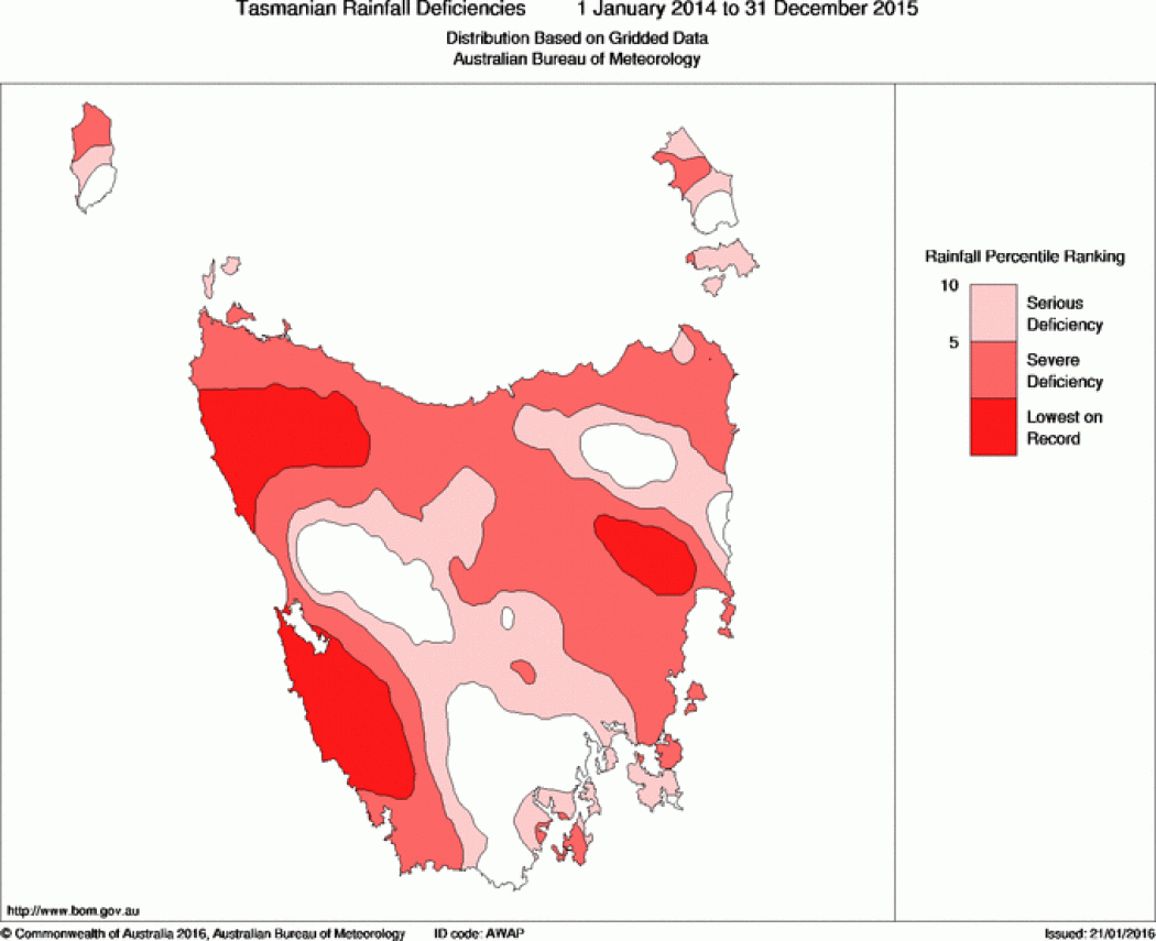
rainfall deficits stretch back much further. This is the tail end of
the driest 24-month period ever recorded in the region where the
fires are burning. Since January 2014, up to 47 inches of rainfall
has gone missing. That’s the equivalent of half a year’s rain.
There’s
also a background signal of decreasing
rainfall since 1970 across
Tasmania, further impacting ecosystems. Those rainfall deficits both
have little to do with El Niño, which only really got ramped up this
year.
This
is the background that has created favorable fire conditions, the
likes of which are rarely seen in a rainforest. Temperatures have
been 3.6°F
(2°C) above average over
the past month, further drying out fuels. It’s all these layers
that have created extreme fire conditions in a place known more for
extreme rainfall.
“I
am of the view this is climate change,” David Bowman, a forest
ecologist at the University of Tasmania, said in an email.
Because
fire is so rare in these temperate rainforests, the trees that live
there are ill-adapted to deal with large blazes. So when the current
fires lit up, they attacked a forest with few natural defenses, like
a bully
coming for your lunch money.
When
the fires die down to embers, they’ll leave behind a landscape
vastly different than the one before it. Trees like the King Billy
Pine and fagus — a beech tree and the only winter-deciduous
tree in Australia — could be burned out of their range on
Tasmania.
These
trees have spent millions of years adapting to slow climate changes.
But the current rate of change is unlikely anything the world has
seen in millions of years.
Temperatures
could rise up to 9°F (5°C) by the end of the century if human
greenhouse gas emissions aren’t slowed. That rate would be faster
than the climate has changed in
at least 65 million years and
would leave not just Tasmania but the rest of the world’s
ecosystems forced to cope with a radical new normal.
World
heritage forests burn as global tragedy unfolds in Tasmania
‘Devastating’
long-term prognosis for ancient Gondwana ecosystem as bushfires turn
trees more than 1,000 years old to tinder
27
January, 2016
A global
tragedy is unfolding in Tasmania. World heritage forests are burning;
1,000-year-old trees and the hoary peat beneath are reduced to char.
Fires
have already taken stands of king billy and pencil pine – the last
remaining fragments of an ecosystem that once spread across the
supercontinent of Gondwana. Pockets of Australia’s only winter
deciduous tree, the beloved nothofagus – whose direct kin shade the
sides of the South American Andes – are now just a wind change away
from eternity.
Unlike
Australia’s eucalyptus forests, which use fire to regenerate, these
plants have not evolved to live within the natural cycle of
conflagration and renewal. If burned, they die.
Fires
have already taken stands of king billy and pencil pine – the last
remaining fragments of an ecosystem that once spread across the
supercontinent of Gondwana. Pockets of Australia’s only winter
deciduous tree, the beloved nothofagus – whose direct kin shade the
sides of the South American Andes – are now just a wind change away
from eternity.
Unlike
Australia’s eucalyptus forests, which use fire to regenerate, these
plants have not evolved to live within the natural cycle of
conflagration and renewal. If burned, they die.
The
fires were preceded and aggravated by the coincidence of two natural
climate events – the Indian Ocean dipole and the Pacific El Niño.
The cooling of the east Indian Ocean caused Tasmania’s usually
drenching spring rains to fail almost completely. El Niño also tends
to bring hot, dry summers. These natural phenomena happen on a
timeframe of decades, not centuries. Confluences have occurred
before, yet the forests did not burn.
The
fires were preceded and aggravated by the coincidence of two natural
climate events – the Indian Ocean dipole and the Pacific El Niño.
The cooling of the east Indian Ocean caused Tasmania’s usually
drenching spring rains to fail almost completely. El Niño also tends
to bring hot, dry summers. These natural phenomena happen on a
timeframe of decades, not centuries. Confluences have occurred
before, yet the forests did not burn.
On
the mainland of Australia and around the world, as the climate warms
the occurrence of catastrophic fires is on the rise. One telltale
sign of climate change is that these fires were set by storms not
people. Lightning was expected to increase under climate modelling,
says David Lindenmayer, a professor of ecology and conservation
biology at the Australian National University in Canberra.
Between
1993 and 2003, Tasmania’s Parks and Wildlife Service recorded 17
fires started by lightning. In the next decade that number rose to
30. In a fire risk assessment of the world heritage area, the service
warned that lightning fires should no longer be viewed as “natural”
because of the influence of climate change. It concluded that
lightning fires were now the main threat to the survival of the world
heritage area.
“Clearly
the fire regime is starting to change,” Lindenmayer says.
In
neighbouring Victoria, major fires that naturally occur every 75 to
120 years have occurred every 20 years, on average, for the past
century.
“That’s
what other people have been forecasting is going to happen,”
Lindenmayer says. “We are going to see more fires, over larger
areas, that are more frequent and of higher severity. What we are
seeing in Tasmania would appear to be a manifestation of that.
Bowman
says: “The implications of this are, of course, goodbye Gondwana.
Because Gondwana can’t live in this sort of world.”
Giant
cushion plants in an ancient pencil pine forest in the Walls of
Jerusalem national park
Tasmania’s
wilderness is to Gondwana, which broke apart 180m years ago, what the
Great Barrier Reef is to coral – the most magnificent example of a
dwindling wonder. That is why Unesco put a vast swath of the island –
1.5m hectares – on its world heritage list in 1982. Once you
account for its Aboriginal heritage, the property fulfils more world
heritage criteria than any other site on Earth.
To
cross this immensely empty landscape takes weeks. As a child, my
parents would often take me on treks among the ethereal alpine
forests of Tasmania’s central highlands; where ragged pencil pines
sit beside bogs and tarns. I was warned never to tread on the cushion
plants. Like the corals of the reef, these communities of tiny plants
build upon the dead skeletons of their predecessors to create the
kind of bulky, alien green globules that a 10-year-old boy just has
to run and jump on. But, in doing so, I’d be destroying hundreds of
years of minute architecture. So lightly, reverentially, we trod
around them.
As
with the world’s corals, climate change is now an immediate threat
to the continuity of this geologically paced building project.
The
Unesco listing is still considered one of the greatest environmental
coups of all time. Victorious campaigners expected the landscape
would be protected against human caprice for their
great-grandchildren and beyond. Never would it have crossed their
minds that the survival of the Gondwanan ecosystem would be
threatened in their own lifetimes.
Like
many Tasmanians, Bowman is a dedicated bushwalker.
“It’s
a bit like knowing someone you love’s got cancer,” he says. “You
have to get your mind around the inevitability, I suppose. You
grieve. It’s a sadness. It’s going to be pretty hard for this
stuff to survive, certainly in the 100-year time frame. It stretches
my mind to believe that there’ll be much of this stuff left in 50
years.”
An
official from Unesco confirms that there is immediate concern at the
agency for the wellbeing of the site and that it has requested
information from the Australian government about the fires. But
Unesco will not comment on whether it has concerns about the
long-term survival of the property under climate change. Unesco was
warned about the potential risk that climate change-driven fires
posed to the site when it sent a mission to the island in November.
At
lower altitudes, outside the world heritage area in the disputed
Tarkine wilderness and across the north of the state, old-growth
rainforests are also burning. The Tarkine’s ancient copses, which
form the biggest rainforest in Australia, are cut through with a
patchwork of logged forests. They take centuries to regrow after
fire. But Lindenmayer says it is “unequivocal” that logging has
put them at greater risk of burning. His research has found that
forests logged within the past 40 years burn hotter and more easily
than if they had been undisturbed.
“You’ve
got these hotspots all through the landscape and those are more
likely to burn at high severity and they are more likely to join up,”
he says. “That means that the unlogged bits that are near the
logged bits are more likely to get fried.
“All
over the globe you see this kind of thing happening where there are
wet forests.”
Geoff
Law, a longtime Tasmanian conservationist and former head of the
Wilderness Society, describes Bowman’s long-term prognosis for the
Gondwanan forests as “devastating”.
“But,
in the meantime, there is a tangible crisis requiring a tangible
solution – aerial water-bombing capacity,” he says. “Pressure
from abroad on the Australian government could help achieve this.”
Tasmanian
fire crews are monitoring roughly 100 fires around the state, rightly
prioritising the protection of property and life. The former
Australian Greens leaders Bob Brown and Christine Milne have written
to Malcolm Turnbull’s government calling for remote firefighting
assistance from the mainland. (Law, Milne and Brown were all among
those who fought the original campaign on the Franklin dam that led
to the creation of the world heritage area.)
Brown
told the ABC’s Radio National: “Tasmania has just experienced the
driest spring in recorded history, then the hottest December. They’ve
had almost no rain in January. Everything is hotter and drier, so we
are facing unprecedented conditions in human history ... due to the
human-caused climate change.”
Bowman
says he hopes rains will arrive to relieve the fire crews. But, “in
a way, it’s a bit immaterial whether the rain comes and puts it out
or doesn’t put it out. If what I’m saying is correct, then we’ve
got to get through next summer and we’ve got to get through all
these summers in a world that’s getting hotter.”

 Posts
Posts