Showing posts with label Wyoming. Show all posts

Sunday, 3 September 2017

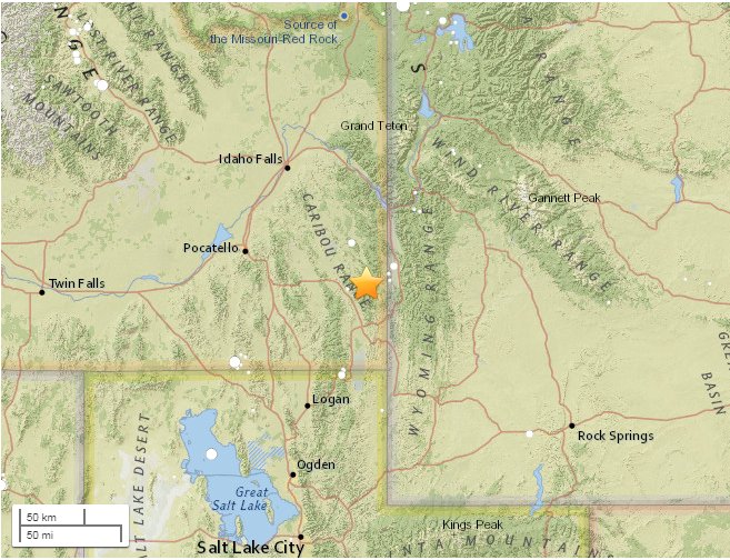
5.3 quake in Wyoming- Idaho

5.3 earthquake strikes Idaho-Wyoming state border area

L
5.3 earthquake strikes Idaho-Wyoming state border area
A powerful 5.3 earthquake has struck Idaho near the state border with Wyoming, some 28km east of Soda Springs which has a population of roughly 3,000 people, the USGS announced.
DETAILS TO FOLLOW

Thursday, 3 April 2014

Warning of super-volcano eruption?


Animals fleeing Yellowstone spark fears of volcanic eruption
Videos of bison seemingly fleeing Yellowstone National Park in Wyoming have sparked concerns among some bloggers that recent seismic activity could trigger the eruption of the park’s so-called supervolcano.

This map from the U.S. Geological Service shows the range of the volcanic ash that was deposited after the biggest of the Yellowstone National Park eruptions around 2.1 million years ago. "These eruptions left behind huge volcanic depressions called “calderas” and spread volcanic ash over large parts of North America," it said. "If another large caldera-forming eruption were to occur at Yellowstone, its effects would be worldwide. Thick ash deposits would bury vast areas of the United States, and injection of huge volumes of volcanic gases into the atmosphere could drastically affect global climate. Fortunately, the Yellowstone volcanic system shows no signs that it is headed toward such an eruption in the near future. In fact, the probability of any such event occurring at Yellowstone within the next few thousand years is exceedingly low."


RT,
2 April, 2014


According to Epoch Times, multiple videos of such incidents have been posted online recently, one of which shows a herd of buffalo allegedly leaving the park and “running for their lives.” Although people behind the discussion acknowledge there’s no way to predict when the park’s massive volcano could erupt, they believe the reaction of the Yellowstone’s animals could signal some kind of alert.

On March 30, Yellowstone was struck by the most powerful earthquake it has experienced since 1980 – a 4.8 magnitude quake that did no damage, but that some believe could be connected to the various animals’ movements.


“Whether I believe this, or whether I don’t believe the story or not, I don’t know. I can tell you this story I saw this morning about the buffaloes running the street … whether or not it’s because of any activity in Yellowstone or not, I don’t know,” said blogger Jay Lee, according to the Times.


“But I’ll tell you this, whatever the case may be, that their running away from Yellowstone is an alert of some sort.”


Another video uploaded to YouTube, this time by self-described “survivalist” and “search-and-rescue expert” Tom Lupshu, claims, “Biologists aren’t sure if there’s been a stunning decline in the herd or if other factors have skewed the tally.” Lupshu also said that helium releases in the area are 1,000 times above normal levels, and accused the US Geological Survey of not reporting small quakes occurring near the volcano.

“Herds of bison running for their lives on the public roadways and they were not being chased or rounded up, the bison were running down the mountain slopes onto roadways running right past a filming crew,” he added. “They detect something vast and deadly. The Yellowstone Supervolcano is the only thing there that would fit the bill.”


The supervolcano – which was found last year to be 2.5 times larger than previously thought – has not erupted in over 640,000 years, leaving some to speculate that a blast is overdue. If and when it erupts again, the volcano could potentially spew ash over large swathes of North America and cause trouble around the entire planet.

"It would be a global event," Jamie Farrell of the University of Utah told the Associated Press last year. "There would be a lot of destruction and a lot of impacts around the globe."

Although Farrell said scientists don’t know enough to map out the next eruption’s likely arrival, he did say they’d know if magma was moving towards the Earth’s surface.
In another video, Lupshu said that increased seismic activity at Yellowstone could bring about the volcano’s eruption, but the Geological Survey has noted such activity is currently par for the course, and that between 1,000 and 3,000 earthquakes hit the area every year. The agency also stated that helium releases have “no implications about volcanic hazards.”

According to Epoch Times, the University of Utah Seismograph Stations also downplayed fears.
“There is no evidence that a catastrophic eruption at Yellowstone National Park (YNP) is imminent,” the service said. “Current geologic activity at Yellowstone has remained relatively constant since earth scientists first started monitoring some 30 years ago. Though another caldera-forming eruption is theoretically possible, it is very unlikely to occur in the next thousand or even 10,000 years.”


Monday, 31 March 2014

4.8 quake in Yellowstone NP

4.8 earthquake rocks US Yellowstone National Park

A 4.8 magnitude quake rocked Yellowstone National Park in Wyoming near the border with Montana, the US Geological Survey said. There were several aftershocks with a magnitude over 3.


RT,
30 March, 2014


The earthquake occurred 37 kilometers northeast of West Yellowstone, Montana at 6:34 am local time (1234 GMT) Sunday.

The quake was centered almost in the middle of Yellowstone National Park, near the Norris Geyser Basin, said Peter Cervelli, a spokesman for the USGS Yellowstone Volcano Observatory, NBC News reported.

He added that any damage from the temblor would likely be minor, noting there are not many visitors in the park at the moment.

There were no immediate reports of damage.

According to USGS there were four aftershocks recorded with a magnitude from 3.1 to 3.3. The USGS said that more are expected.

The secondary shockwaves are usually less violent than the main quake but can be strong enough to do additional damage to weakened structures, the USGS said.

Cervalli stated that the quake is not expected to trigger any volcanic activity.

Yellowstone National park, North America's largest volcanic field, is the home to a caldera, sometimes referred to as the Yellowstone Supervolcano. Due to the volcanic and tectonic nature of the region, the caldera experiences 1 to 20 earthquakes every day, according to Yellowstone observatory. However they are very weak often measuring much less than magnitude 3.

The quake on Sunday was the most powerful to hit the park since 1985. In the fall of 1985 in the northwest rim of the caldera during a three-month period of increased earthquake activity over 3000 events of magnitude 0 to 4.9 were recorded by seismologists.

Geologists are closely monitoring the rise of the Yellowstone Plateau. The upward movement of the Yellowstone caldera floor between 2004 and 2008 was almost 3 inches (about 7 cm) each year, according to a University of Utah scientists report in the journal Science in November 2008. That was more than three times greater than ever observed since such measurements began in 1923.

"Our best evidence is that the crustal magma chamber is filling with molten rock," said seismologist Robert B. Smith, lead author of the study and professor of geophysics at the University of Utah.


"But we have no idea how long this process goes on before there either is an eruption or the inflow of molten rock stops and the caldera deflates again," he added.


Heightened seismic activity in the state of Oklahoma


Saturday, 1 March 2014

CO2 emissions


Wyoming leads in CO2 per person; top coal mining state is a reluctant enforcer of emissions


28 February, 2014


CHEYENNE, Wyoming — Turns out the worst state for carbon dioxide emissions per person isn't smoggy California or bustling New York, but a place famous for its big, clear skies: Wyoming.

But regulating greenhouse gases is a touchy subject in the least-populated state, which just recently received U.S. Environmental Protection Agency approval to do so.

Wyoming also is the top coal-mining state by far, producing almost 40 percent of the nation's coal. Burning coal to generate electricity produces large amounts of CO2 — in Wyoming, across the U.S., and in the Far Eastern countries where state officials have sought to open up new coal markets.

Gov. Matt Mead made such a trip to Taiwan and South Korea last year. Meanwhile, he's called EPA efforts to curtail greenhouse emissions a "war on coal" and said at a recent forum he's skeptical about man-made climate change.

"What he also says is we do have a responsibility to always do things better," Mead spokesman Renny MacKay said Thursday. "The coal industry has to be profitable if it's going to invest in the research and development of new technologies."

MacKay highlighted the state's efforts to make its coal cleaner: $50 million allocated toward new coal-burning technology at the University of Wyoming and plans by the state to support a proposed $10 million X Prize to develop economically feasible carbon-capture technology at an operational coal-fired power plant.

He said the EPA shouldn't impose rules that cripple coal-fired electricity by requiring still-unattainable greenhouse reductions, but, instead, should gradually implement rules as new technologies to cut carbon emissions become available.

The stakes for Wyoming are high. Minerals taxes on coal provided $1 billion to the state and local governments in 2012 and coal mining supports some 6,900 jobs in the state.

Last year, Wyoming's coal production fell 3 percent amid more stringent environmental regulations and inexpensive natural gas, a cleaner fuel source in growing use by electric utilities.

Meanwhile, per person, Wyoming faces an outsized challenge to regulate greenhouse gases on a shorter timeframe than breakthrough technologies are likely to allow.

In 2011, Wyoming emitted 64 million metric tons of carbon dioxide, according to figures released Wednesday by the U.S. Energy Information Administration.

Spread out over the smallest population of any state — about 568,000 people lived in Wyoming in 2011 — that works out to more than 112 metric tons of carbon dioxide per person, or more than six times the national average.

Burning coal — nearly all of it to make electricity — accounted for 69.2 percent of Wyoming's CO2 emissions, twice the U.S. average.

Only West Virginia (80.9 percent) and North Dakota (69.4 percent) had more of their CO2 emissions come from coal.

Wyoming residents aren't solely responsible for all of those emissions. Wyoming exports to other states about 68 percent more electricity than it consumes in state.

"Certainly other states, to put it mildly, they have blood on their hands as well," Jeremy Nichols of WildEarth Guardians said Thursday.

The group has two active lawsuits opposing coal mining in Wyoming on climate-change grounds.

In December, Wyoming became one of the last several states to get EPA approval to regulate greenhouse gases. For over a year and a half, the EPA regulated greenhouse emissions in Wyoming while the state regulated other types of air emissions, a "dual permitting" process that resulted from a 1999 state law that said Wyoming wouldn't enact any regulation reducing greenhouse gases.

The Legislature repealed the law over the last two years.

State regulators say they're still waiting to see many details of how the EPA intends to regulate greenhouse emissions, including possible new rules for existing power plants, said Steve Dietrich, head of the Wyoming Department of Environmental Quality's Air Quality Division.

Other states with high per-capita CO2 emissions included North Dakota, at about 78 metric tons per person, followed by Alaska (53) and West Virginia (52).

Vermont, California and Connecticut had the fewest emissions per person, all with just above 9 metric tons per capita.

Saturday, 5 October 2013

Extreme weather in America

Evacuations ordered as Tropical Storm Karen nears U.S. coast
Authorities issued mandatory evacuation orders for low-lying areas south of New Orleans on Friday as a weakened Tropical Storm Karen closed in on the Louisiana coast after disrupting U.S. energy output in the Gulf of Mexico.


4 October, 2013

Karen's top winds dropped to 45 mph, down from 65 mph a day earlier, although National Hurricane Center forecasters in Miami said the storm was expected to strengthen slightly on Saturday but remain a tropical storm.

Oil output in the U.S. Gulf of Mexico had been cut in half as oil and gas firms shut platforms and evacuated some workers in preparation for the storm. The Gulf accounts for about 19 percent of U.S. oil production and 6 percent of natural gas output.

The mayor of Grand Isle, Louisiana, clamped a mandatory evacuation on the popular vacation and fishing destination on a barrier island south of New Orleans. Evacuations were also ordered in Lafourche Parish in the south, and residents in much of Plaquemines Parish, southeast of New Orleans, were told to be out of their homes before nightfall.

The Sand Dollar Motel and Marina on Grand Isle was a frenzy of activity on Friday as boaters scrambled to get their vessels to higher ground and marina employees secured the premises.

"It's already pouring here and the wind is real strong," said marina owner Susan Gaspard, who added that squalls had been hitting all morning.

Karen's projected path shifted slightly westward and it was expected to move ashore over Louisiana on Saturday night and into Mississippi and then Alabama on Sunday.

By late Friday afternoon, the storm was centered about 235 miles south-southwest of the mouth of the Mississippi River. It was moving north-northwest but was forecast to turn to the northeast as it crossed the coast.

At the Port of New Orleans, cargo operations continued normally, but the harbor pilots who guide ships through the mouth of the Mississippi had ceased operations.

"No ships are coming in or out the mouth of the river," said port spokesman Matt Gresham.

Carnival Cruise Line officials announced that two ships that had been due to arrive in New Orleans over the weekend, the Carnival Elation and Carnival Conquest, could be delayed until Monday. Guests onboard were being kept apprised and the ships were sailing at a safe and comfortable distance from the storm, the company said.

'GOOD SQUALL'

The governors of Louisiana, Mississippi, Florida and Alabama declared states of emergency to speed storm preparations and the Federal Emergency Management Agency recalled some furloughed workers to assist.

The storm was expected to dump up to 6 inches of rain in its path and to push a surge of seawater over the shoreline, the hurricane center said.

"The tide's already high, so we know we will get water. We're just trying to put everything up as high as we can," said Gaspard on Grand Isle.

Ralph Atkins, owner of Southern Fish & Oyster Co on a downtown dock in Mobile, Alabama, said he expected to see a "good squall" from Karen but nothing he couldn't deal with.

"Our big trouble is water. Water can build up and make it bad," Atkins said. "It's just another day in the fish business. Nature just needs to take a bath every now and then," he added.

At Alabama's Grand Mariner Marina on Dog River and Mobile Bay, boaters were tying down the larger vessels with double ropes and putting the smaller ones on trailers to haul them up the river to sheltered coves.

"It's like New York City at lunch time here. We are really busy," said marina manager Steve Penny. "We are doing everything we can to make room for 4 to 6 feet of water. Anything we can move, we get out."

Marina workers were adding fuel to their 8,000-gallon (30,280-liter) tanks to weigh them down and keep them from floating away.

A hurricane watch for the coast from Grand Isle, Louisiana, to Destin, Florida was dropped. Tropical storm watches and warnings were still in effect in other areas including metropolitan New Orleans and Lake Pontchartrain. Tropical storms carry winds of 39 mph to 73 mph.


Record October Snow in South Dakota & Summer-like Heat in the Northeast

WeatherNation Chief Meteorologist Paul Douglas says America is like the Superbowl of weather seeing more extreme weather than any nation on earth. And today is a great example of that. Folks in South Dakota are digging out from more than two feet of snow while it's a beach day in the Northeast.


Early Fall in South Dakota

Trees and powerlines are down and white conditions dominate the afternoon across western South Dakota where emergency management officials are telling folks to stay home. Wind gusts have hit 51 mph at Rapid City within the hour and already range as high as 59 mph in areas nearby as a blizzard grips the area. This spectacular photo from my colleague Darren Leeds, FOX meteorologist for the Black Hills lays out the wintry scene in downtown Lead, SD--a town without power and under 22" of snow. 12.5" is reported down at Gillette, 11" at Hulett and 12" at Deerfield with the storm in its early stages.


Nebraska and Iowa Tornadoes

A strong surface low, warm temperatures, and moist unstable atmosphere, brought a late season severe weather outbreak. A total of 17 confirmed tornadoes reported to the National Weather Service. Large hail and damaging wind were also reported.


Unseasonably early snow storms bury Wyoming and South Dakota


4 October, 2013


October 4, 2013 – MIDWEST - It may only be October, but a severe snowstorm has already buffeted Wyoming and South Dakota and threatens the rest of the Midwest Friday. 

This unseasonably early snow is strong with almost three feet of snow falling in South Dakota, and residents preparing for even more. 

Winter Storm Atlas is also expected to bring heavy snowfall, severe thunderstorms and tornadoes to parts of the Rockies, the Plains and Midwest. 

“I’ve lived in Wyoming my whole life and I’ve never seen it like this, this early. I know several of the businesses nearby are completely closed because they can’t even get workers into work — it’s pretty nasty,” Patricia Whitman, a truck stop shift manager, said to the Associated Press. 

Winter Storm Atlas could be the earliest snowfall on record in towns throughout the Midwest, and it’s already made its impact felt. 

The snow has crushed tree lines and destroyed power lines, causing many residents in Wyoming and South Dakota to lose power. 

Accuweather.com reports that the storm has caused 470 flight delays at Denver International Airport. Numerous roads have been closed, including sections of the I-90 and I-25. It also spawned a tornado in Nebraska, although no one was injured when it touched down. 

The storm is expected to dissipate over the weekend, with highs in Denver to reach the 70s by early next week. 

–PBS