Showing posts with label tar sands. Show all posts

Wednesday, 25 May 2016

Canada's Crime against the Planet

Canada’s shocking oilsands operation (Aerial footage)
Alex MacLean is one of America’s most famed and iconic aerial photographers. His perspective on human structures, from bodies sunbathing at the beach to complex, overlapping highway systems, always seems to hint at a larger symbolic meaning hidden in the mundane. By photographing from above, MacLean shows the sequences and patterns of human activity, including the scope of our impact on natural systems. His work reminds us of the law of proximity: the things closest to us are often the hardest to see.

Recently MacLean traveled to the Alberta oilsands in western Canada. There, working with journalist Dan Grossman, MacLean used his unique eye to capture some new and astounding images of one of the world’s largest industrial projects. Their work, funded by the Pulitzer Center on Crisis Reporting, will form part of a larger, forthcoming report for GlobalPost.

DeSmog Canada caught up with MacLean to ask him about his experience photographing one of Canada’s most politicized resources and the source of the proposed Keystone XL and Northern Gateway pipelines.


Forest removal for exploratory well pad. Shell Jackpine mining site, North of Fort McMurray, Canada.
Beds leading up to tailing pond.
Mining operations at the North Steepbank Extension. Suncor mine, Alberta, Canada.
Suncor Oil Sands Project. Piles of uncovered petrolum coke, a byproduct of upgrading tar sands oil to synthetic crude. “Petcoke” is between 30-80 per cent more carbon intense than coal per unit of weight.
Syncrude Mildred Lake mining site. View south to upgrading facility with rising plumes of steam and smoke. Alberta, Canada.
Patches of boreal forest intertwined with snow-covered muskeg, near McLelland Lake, Alberta, Canada.
Steam and smoke rise from the Syncrude Mildred Lake mining facility.
Earthen wall to tailing pond. Suncor mining site, Alberta, Canada.
Hot waste filling tailing pond. Suncor mining site, Alberta, Canada.
Smoke, steam, and gas flares rise from the Suncor upgrading facility. Reclamation efforts seen to the right, on what was once a tailing pond. Suncor has reclaimed only 7 per cent of their total land disturbance.
Seismic lines and well pad for exploratory drilling through the boreal forest at the Suncor Firebag Oil Sands Project. Alberta, Canada.
Checkerboard clearing of the overburden at Syncrude Aurora North mine site. Alberta, Canada.
Clearing, dewatering, and seismic grid over the once boreal forest. Syncrude mining site, Alberta, Canada.
Open box cars carrying sulfur byproduct. Edmonton, Canada.
Surface oil on tailing pond. Suncor mine near Fort McMurray.
Overview of tailing pond at Suncor mining site.
Growing pyramids of sulfur, a byproduct of upgrading bitumen. Mildred Lake, Alberta, Canada.

DeSmog Canada: What was it like photographing the oilsands? Was it different 
from photographing other large-scale human spaces like highways or beaches?

Alex MacLean: The oilsands covered a vast area of which I was only able to 
photograph part of. It was not only different from highways, beaches, etc., in that 
those are linear formations, but the scale of the oilsands area and the devastation
 to the landscape was overwhelming. I felt a relation between highways and the 
mines in that open pit mines and seismic exploration lines fragment the boreal 
forest just as highways do through urban areas.

DeSmog Canada: What led to your interest in the Alberta oilsands?

Alex MacLean: I have been photographing around the issues of climate change 
since early on, and actually put out a book looking at land use patterns as they 
relate to energy and consumption in 2008 called “OVER: The American Landscape 
at the Tipping Point.” I was drawn to photographing the pipeline because I feel as 
though there is little public awareness that, if built, the Keystone XL will make 
avoiding catastrophic climate change much harder. The pipeline is an important 
link in a fossil-fuel production machine, stocked with bitumen deposits at one end 
and refineries at the other. The public is unaware that this oil production machine
is poorly regulated, though it will cause serious environmental and health effects on 
local, regional and planetary sales.

DeSmog Canada: What is it like taking a bird’s eye view of humanity? Do you 
sometimes have great insights looking at civilization from such a removed, 
abstracted position?

Alex MacLean: One of the interesting things about aerial photography is how so 
much of what you see about humanity is devoid of people. What I see is tracks 
and markings that are telling about our culture and values. When you see the 
destruction of landscapes, in this case of the boreal forest, with the obvious 
contamination of the environment via water and air pollution, you can’t help but 
feel that there is very short-sighted exploitation of natural resources that will have 
long-lasting environmental impacts.

DeSmog Canada: You’ve been photographing ‘human’ spaces for a long time. 
Have you noticed a change over the last few decades in your perspective as 
society has grown more aware of the ecological crisis and the scale 
of our impact?

Alex MacLean: You can’t help but notice the growth that has taken place in the 
last thirty years, and the build-out of what was once natural spaces. I would say in
 the last 15 years, at an escalating rate, you begin to see more sustainable 
sources of energy through wind and solar farms, and reconfiguring of urban 
spaces to make them more walkable.

Wednesday, 18 May 2016

The Tar Sands and the destruction of Alberta

BP Earth Watch presents a stark vision of the destruction of Alberta and the destruction of the planet.


He shows the changing of the landscape and the unprecedented destruction – all for the greed of men.

This fire seems like retribution – Nature, indeed Bats Last

As an non-Christian I have no objection to his quotation of Revelation 11:18

The nations were angry, and your wrath has come. The time has come for judging the dead, and for rewarding your servants the prophets and your people who revere your name, both great and small-- and for destroying those who destroy the earth."


It seems quite apt today

The Destruction of Alberta


These fires are like nothin else seen before and can create their own weather including lightning which and can relight themselves.

Canada wildfire: why a sleeping giant awoke in Alberta and became relentless

Those on the front lines ask what made this fire of ‘unprecedented speed’ different from the hundreds of other blazes that ignite yearly in the region


15 May, 2016

A multi-headed monster. An animal of fire. The Beast.

As it raged out of control across northern Alberta and burst into Fort McMurray with unparalleled ferocity, the wildfire began racking up a list of colourful nicknames.

Within the span of a few days, the blaze had swelled in size, from some 1,200 hectares (3,000 acres) to more than 220,000 hectares (544,000 acres) . It cut a path of destruction through Fort McMurray, a city in the heart of Alberta’s oilsands, forcing the evacuation of more than 88,000 people and flattening some parts of the city, leaving a trail of charred rubble in its wake.

Few on the front lines had ever seen anything like it. “It’s an unprecedented fire with respect to the rate it spread, how it involved the community,” said regional fire chief Darby Allen earlier this week, after cooler temperatures and higher humidity allowed crews to get a handle on the fire.

The way this thing happened, the way it travelled, the way it behaved – they’re rewriting their formulas on how fires behave, based on this fire,” he said.


So what made this fire different from the hundreds of others that ignite yearly in the region, or other wildfires around the world? “We’ve had faster fire speeds, we’ve had bigger fires, but this one, in terms of impact and where it landed, it is definitely historic,” explained Chad Morrison, Alberta’s manager of wildfire prevention.

A 2011 fire in northern Alberta grew to more than 700,000 hectares (1.7m acres). Another, in 1951, burned some 1.4m hectares (3.5m acres), becoming one of the largest recorded fires ever seen in North America. But these fires burned in remote areas of the province, Morrison said. “I don’t think we’ve ever seen a community of this size and scale be impacted by a wildfire of this size and ferocity.”

The fire pitted firefighting crews – often more used to battling blazing houses or apartments – against a wildfire capable of sweeping through entire neighbourhoods. Firefighters managed to save around 85% of the city, leaving an estimated 2,400 homes and buildings to the flames.

The cause of the extreme fire, which first ignited in a remote forested area, remains under investigation.

Shifting winds early last week saw the fire swiftly transform from one that was largely under control into a raging blaze that breached the boundaries of Fort McMurray. At one point, the fire managed to jump a kilometre-wide river.


No amount of tankers or resources, or no size of firebreak, could have prevented it from hitting the community that day,” Morrison said. “Sometimes Mother Nature is going to do what it wants to do and bad things happen.”

The “nasty, dirty” fire – in the words of the local fire chief – surprised scientists by igniting its own fires, said Mike Flannigan, who studies wildland fire at Edmonton’s University of Alberta.

Fuelled by tinder and helped along by unseasonably warm weather and low humidity, the fire released massive amounts of energy as it moved, creating its own weather, including lightning. Fires that produce lightning are not unheard of, said Flannigan. “But this one generated lightning and then generated new fire starts. That’s the first time I’ve heard this.”

As the fire made headlines around the world, many were quick to link its extreme behaviour to climate change. But Kerry Anderson, a fire research scientist with Natural Resources Canada, said the long-term records needed to firmly establish whether this link existed. “We know that forest fires occurred 100 years ago, but it’s not really until the last 15 or 20 years that we’ve gotten a fairly reliable record of the fire area being burned every year.”

He pointed to the current El Niño event to explain the extreme fire. A mild winter in Canada saw the fire season start some four weeks earlier than usual and helped created the tinder-dry conditions. “Fire is a natural part of the environment in Canada … If it weren’t for fires, mature forests would suddenly be susceptible to fire and disease.”

Others say climate change could make these kinds of extreme fire events the new normal. “We have a temperature and it’s turning into a fever and we’re trying to ignore it,” said Tim Lynham, a fire behaviour expert with Natural Resources Canada.

Climate warming has seen snow melt earlier, leaving soil and vegetation drier and helping to push the fire season to begin earlier. The result is a longer period of the year when fires can occur, said Lynham. “And with that will come more threats to communities.”

More than 500 firefighters continue to fight the blaze in northern Alberta. Its growth has slowed in recent days and its size now hovers around 241,000 hectares. Winds have helped shift its movement away from the communities.

Across Alberta, where more than 15 wildfires are currently burning, firefighters continue to aggressively focus on the fire they call the Beast, all too conscious of its latent strength and power to wreak havoc.

It’s kind of a sleeping giant in that forested area,” Morrison said. “And someday, when it gets hot and dry again, it’s going to wake up and go for a little walk in the forest and burn some more.”


1984


2011


Fort McMurray fires: the Beast roars back into the tar-sands

We are living now in the Age of Consequences on a day where nothing else really matters, except for the rapid growing climate crisis (that's the wrong noun) and the consequences.


"Such huge extents of extreme fire hazard over northern and far-northern regions that typically experience much, much cooler weather is a feature that is absolutely consistent with effects resulting from human-forced warming. A warming that continues to be made worse by the extraction of carbon-based fuels like those unearthed at the tar sands facilities now endangered by the very fires of climate change they helped to ignite."


First just the facts presented in a way that matters.

The Beast Growls — Warming-Induced Wildfire Again Doubles in Size, Burns Tar Sands Workers’ Camp


18 May, 2016
On Monday, strong southerly winds and freakishly hot temperatures near 80 degrees (F) combined to fan the still-raging Fort McMurray Fire in Alberta, Canada. The monstrous, climate change enhanced, blaze swelled. And by the end of the day it had expanded to cover more than 354,000 hectares, 1,360 square miles, or an area larger than the state of Rhode Island.
In a little more than a week, a fire that emergency response personnel are calling ‘The Beast’ had once again doubled in size.
The Beast Growls
(The Fort McMurray Fire again exploded on Monday — invading tar sands facilities even as the eastern sections of the fire came to within 7 kilometers of the Saskatchewan border. Image source: LANCE MODIS.)

As the fire expanded, it swept north and east. Casting off choking, dense smoke, the fire spiked air quality ratings to 38 (a 10 is considered dangerous), forcing emergency response personnel, workers, and those few people now inhabiting the blackened town of Fort McMurray to wear particulate filtration masks. The bad air quality caused some officials to speculate that the return of more than 80,000 residents to the town could be delayed. The evacuees had been forced from their homes by the fires during early May — a wave of climate change refugees that have now faced a three week period of dislocation. But any thought of residents returning was swiftly overwhelmed by the rapidly-expanding fire itself.

8,000 More Evacuations, Oil Worker Camp Burned

As the town of Fort McMurray choked in the smoke of resurgent fires, walls of flame moving north and east again threatened tar sands facilities. Firefighters scrambled to widen fire breaks as fires moving as fast as 40 kilometers per hour leapt defensive lines and entered some of the industrial sections.
Ironically-named Travis Fairweather, a wildfire information officer, described the completely untenable situation:
Yesterday the fire was showing extreme behaviour and lots of smoke in the air. We had to pull the firefighters off the line because it was so dangerous out there.”
The entire industrial zone fell swiftly under threat and by late Monday more than 8,000 tar sands workers from a total of 19 camps had been ordered to evacuate. By Tuesday morning, the Blacksand Lodge — a temporary residence for oil workers manning tar sands facilities located 35 kilometers to the north of Fort McMurrary — had succumbed to the flames. A large facility, the Blacksand camp provided 665 residential units for workers. In total, it’s estimated that about 6,000 workers remain in tar sands facilities and emergency responders are coordinating to organize an air evacuation if necessary.

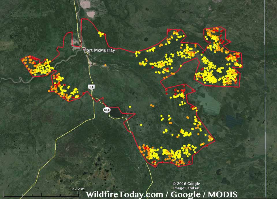
Fort McMurray fire extent May 16
(Fort McMurray Fire extent with hotspots as of early Monday on May 16. The region affected by the fire as of this time was truly vast — stretching nearly 50 miles long and 30 miles wide. Through late Wednesday, the massive blaze is likely to again claim more ground. Image source: Wildfire Today.)

Fire Situation to Remain Extreme on Tuesday and Wednesday

Southerly winds and far above average air temperatures are again expected to worsen fire conditions on Tuesday and Wednesday. Highs are predicted to hit near 80 in Fort McMurray on both days and dry conditions are expected to dominate. So continued rapid growth of the McMurray Fire over this period is likely. With fires now on three sides of the industrial zone and within sections of the tar sands facilites, we can expect a continued threat to the oil production zone over at least the next 48 hours.
Long range forecasts indicate that warmer than normal conditions are likely to continue over the next week. However, rainfall predicted on Thursday and Saturday could again slow the fire’s growth — giving firefighters another shot at containing this massive blaze. It’s worth noting, though, that the fire is now so large and intense that it will likely take weeks to months to extinguish.
Extreme Fires in the Context of Human-Caused Climate Change

Overall, more than 530,000 hectares have now burned throughout Canada. This total is more than 24 times the amount of land consumed in fires by this time last year. During the 20th Century, large May burn extents of the kind Canada is experiencing during 2016 were unheard of. For much of Canada — May tended to be a cool month featuring temperatures in the 40s, 50s and 60s (F). Not the 70s and 80s (F) that have tended to crop up so frequently this year. Fires tended to be sparse and small — if they ignited at all. But the heat, a growing number of dead trees, and a thawing zone of carbon-rich and flammable permafrost have all added to the fire danger. Evidence that a very rapid pace of warming and related damage to Canada’s forests is having an extraordinary and dangerous impact.


Over the coming seven days, abnormal 60-70 degree (F) temperatures are expected to expand throughout even the far northwestern regions of Canada — reaching all the way to where the Arctic Ocean meets the Mackenzie Delta and spiking fire hazards within that thawing permafrost zone. Such huge extents of extreme fire hazard over northern and far-northern regions that typically experience much, much cooler weather is a feature that is absolutely consistent with effects resulting from human-forced warming. A warming that continues to be made worse by the extraction of carbon-based fuels like those unearthed at the tar sands facilities now endangered by the very fires of climate change they helped to ignite.

Links:
Hat tip to DT Lange
Hat tip to Colorado Bob
Hat tip to Greg
Hat tip to Redsky