Subscribe to


Showing posts with label oice melt. Show all posts
Showing posts with label oice melt. Show all posts
Friday, 6 October 2017
Paul Beckwith on Arctic sea ice
Arctic Sea Ice: Everything You Need To Know
Every
summer now, there are many people anxiously monitoring the seasonal
melt-back of the Sea Ice that covers the Arctic Ocean. One of these
summers, likely within the next 5 years we will end up with no sea
ice left at the end of the summer. This “blue-ocean” event will
change our climate & lives, in numerous ways.
Wednesday, 16 November 2016
Global Sea Ice Values - Arctic and Antarctic - are Plummeting
From Pole to Pole, Global Sea Ice Values are Plummeting
During
the record hot year of 2016, both Arctic and Antarctic sea ice
extents took a huge hit.
15
November, 2016
Extreme
warmth in the Arctic helped to produce leading losses there. Values
that began during January at 1 million square kilometers below
average have steadily declined as the months progressed to near 2
million square kilometers below average. Meanwhile, the Antarctic —
which began the year at near average sea ice extent values — saw
significant losses as the region grew anomalously warm during austral
spring. Today, sea ice extent values surrounding the Antarctic are
now also just shy of 2 million square kilometers below average.

(Zachary
Labe, one
of the most well-recognized up and coming U.S. climate scientists,
has produced this graph based on NSIDC recorded global, Arctic, and
Antarctic sea ice values. As you can see, global sea ice extent
during the hottest year on record has steadily plummeted to near 4
million square kilometers below average as the months progressed.
Image source: Zack
Labe’s Sea Ice Figures.
Data source: NSIDC.
You can also follow Zack’s
informative twitter feed here.)
In
total, global sea ice coverage is now about 3,865,000 square
kilometers below average.
If
you think that number sounds really big, it’s because it is. It
represents a region of lost ice nearly 40 percent the size of the
land and water area of the entire United States including Alaska and
Hawaii. To visualize it another way, imagine all of the land area of
Alaska, California, Texas, Montana, Arizona and New Mexico combined
and you begin to get the gist.
Sea
Ice Coverage — An Important, But Complex Climate Indicator
Many
climate specialists have viewed sea ice as a kind of climate change
canary in the coal mine.
Sea ice sits upon the warming oceans and beneath a warming
atmosphere. And these oceans are now
taking up the majority of the heat being trapped in the atmosphere by
fossil fuel emissions.
Warming ocean surfaces have a higher specific heat value than the air
and this greater
overall energy capacity in
warming regions generates a substantial blow to ice coverage even if
the initial water surface temperature swing is only moderate.
Once
sea ice is lost for a significant period, a kind of feedback loop
comes into play where dark ocean surfaces trap more of the sun’s
rays during polar summer than once-white ice coverage — which
previously reflected radiation back toward space. This newly absorbed
heat is
then re-radiated back into the local atmosphere during polar fall and
winter —
creating an inertial barrier to ice reformation and ultimately
generating a big jump in seasonal ocean and atmospheric surface
temperatures.

(Highly
pronounced ocean surface warming coupled with warm air invasions
appears to be generating the extreme losses to sea ice now seen in
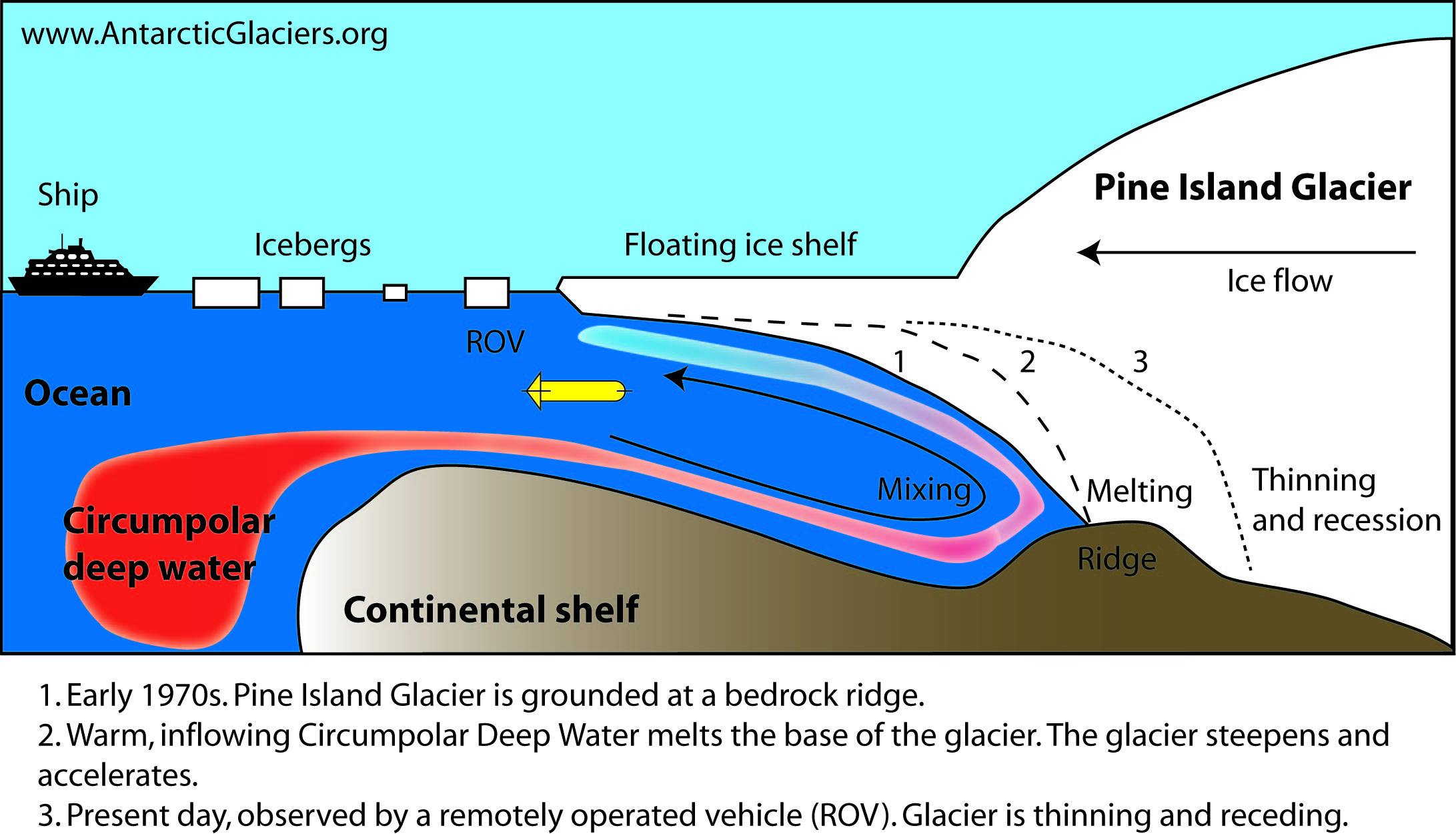
the Arctic. The Barents Sea, shown above, has seen particularly
extreme warming. Note the 11 C above average hot spot near the sea
ice edge zone. In the Antarctic, the causes of losses remain
uncertain. However, atmospheric warming and shifts in the circumpolar
winds appear to be producing this effect even as slightly cooler than
average surface waters remain in place — possibly due to storm
related Southern Ocean upwelling and increasing fresh water outflows
from Antarctic glaciers. Image source: Earth
Nullschool.)
This
dynamic is particularly pronounced in the Arctic where a thawing
ocean surrounded by warming continents tends to readily collect heat
even as atmospheric energy transfers from the south, in
the form of warm wind events,
have grown more pronounced. An effect related to the climate change
influence known as Northern Hemisphere Polar Amplification.
In
the Antarctic, the stormy Southern Ocean generates up-welling. This
dynamic tends to cool the ocean surface even as it transfers heat
into the deeper ocean. And increasing stormy conditions surrounding
Antarctica related to climate change can intensify this effect. In
addition, warm
bottom waters melting sea-fronting glaciers in Antarctica produce a
lens of fresh water which cools the surface and also traps heat
below.
So the signal coming from Antarctica with regards to sea ice has
tended to be more mixed — with atmospheric warming and changes in
wind patterns generating more variable sea ice impacts relative to
the Arctic. So this year’s sea ice losses there are more difficult
to directly link to climate change even though climate change related
influences on the physical system in the Antarctic and among its
surrounding waters are becoming more and more apparent.
Zack
Labe notes
that:
The Arctic sea ice anomaly, however, fits with the ongoing Arctic amplification trend of thinning sea ice and loss of old ice. Additionally, it has been well noted in previous literature (i.e., http://onlinelibrary.wiley.com/doi/10.1029/2010GL044136/full …) concerning the increasing fall temperatures in the Arctic and possible causes.
Major
Volume Losses From 2015 to 2016
Despite
big losses to sea ice surrounding the Antarctic this fall, it is the
Arctic where the damage and risk of further loss is most pronounced.
Particularly, reductions to thicker, multi-year ice in the Arctic
during 2015 to 2016 have been exceptionally severe:


In
the above images, we see a comparison between late November sea ice
coverage and thickness as
provided by the U.S. Navy ARCc model.
The left frame represents late November of 2015 and the right frame
represents projected values for November 20, 2016. Note the greatly
reduced coverage in the 2016 image. But even more noteworthy is the
substantial loss of thicker ice in the Arctic Ocean north of the
Canadian Archipelago and Greenland.
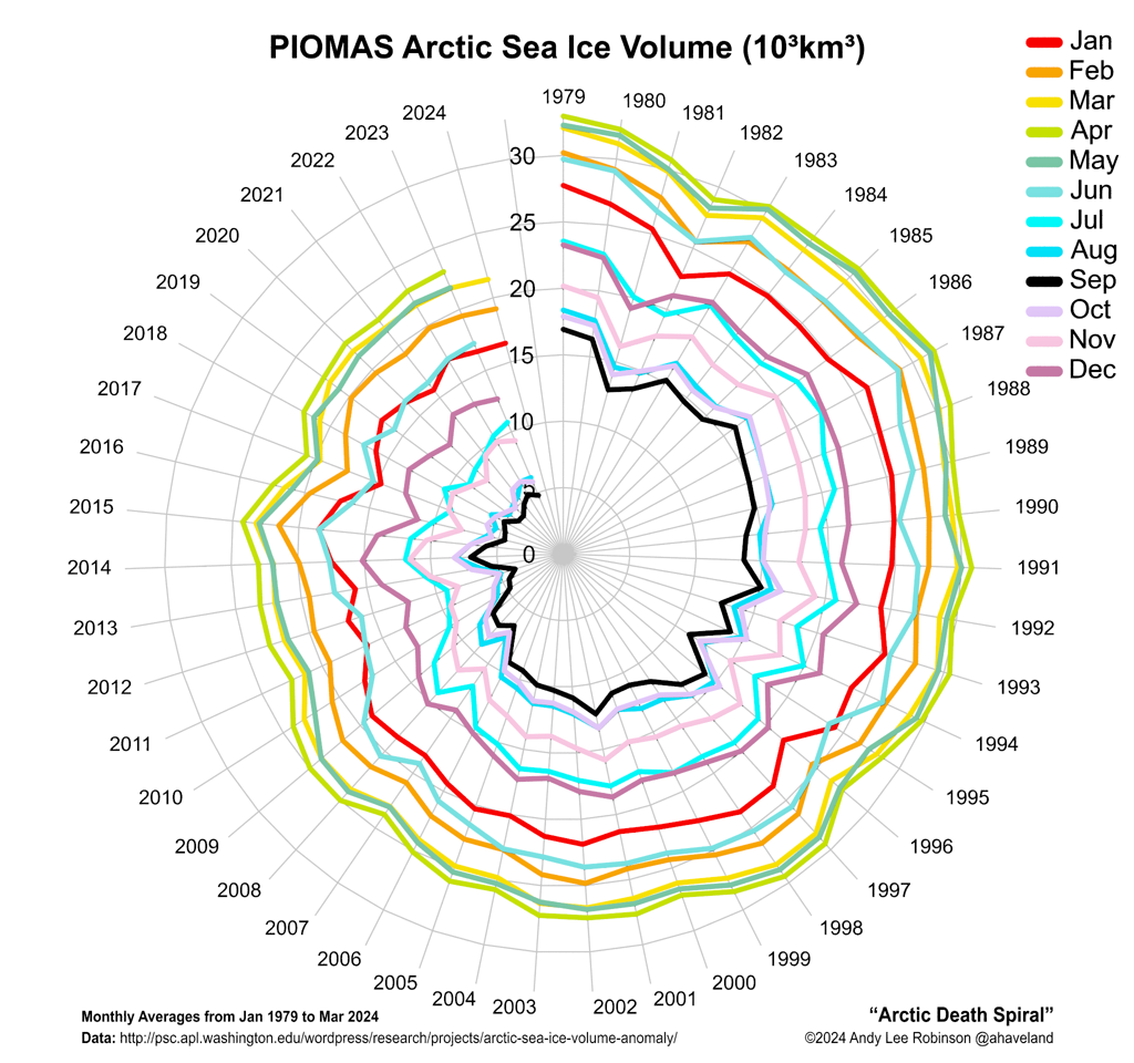
These
two images tell a tale of a great loss of sea ice volume. One that
the sea ice monitor PIOMAS confirms.
According to PIOMAS, ice volume values during
October were tracking near lowest levels ever recorded.
And continued heat into November generates a concern that a period of
new record low volume levels may be on the way.
But
it’s not just the record low values that should be a concern. It’s
the location of the remaining thick ice that’s a worry as well. For
a substantial portion of the remaining thick ice is situated near the
Fram Strait. Wind and ocean currents tend to push ice out of the
Arctic Ocean and through the Fram. Ice tends to then be funneled down
along the coast of Greenland and on into the North Atlantic where it
melts. So the fact that a big chunk of the already greatly reduced
remaining thick ice now sits on the edge of the sea ice version of
Niagra Falls is not a good sign.
La
Nina Years Tend to Push More Heat Toward the Poles
It
is notoriously difficult to accurately forecast sea ice melt and
refreeze trends in the various seasonal measures for any given
individual year. And even many of the top sea ice experts have had a
devil of a time forecasting the behavior of sea ice during recent
years. However, one thing remains quite clear — the long term trend
for sea ice in the Arctic is one of rapid decline.

We
are now entering a situation where one very warm winter followed by
one warmer than normal summer could push Arctic sea ice values to
near the zero mark. A situation that could effectively set off a blue
ocean event in the near future. A number of prominent sea ice experts
have predicted that it’s likely that such a state will be achieved
rather soon — by
the early 2030s under current trends.
Others point
toward nearer-term loss potentials.
But there is practically no-one now saying, as was often stated
during the early 2010s, that a blue ocean event could hold off until
the early 2050s.
All
that said, the trajectory going into 2017 for the Arctic at present
doesn’t look very good. Both sea ice extent and volume are now at
or well below the previous low marks for this time of year. Remaining
thick ice positioned near the Fram Strait generates a physical
disadvantage to the ice in general. In addition, NOAA
has announced that La Nina conditions are now present in the
Equatorial Pacific.
And La Nina events tend to push more ocean and atmospheric heat
toward the poles — particularly toward the Arctic.
Links/Notes/Disclaimer:
Note:
This article is written as a follow-on to the previous blog post
— For
The Arctic Ocean Above 80 North, It’s Still Summer in November —
and they should be read together for context.
Disclaimer: I
asked PhD
student Zachary Labe to
make a general comment on sea ice trends, to which he generously
provided his particular take on the Arctic. I have also made my own
best-shot science and observation-based analysis of the situation
given current trends. Because of the fact that the present situation
is new and evolving, some of my statements may well pass outside the
bounds of currently accepted science. The fact that Labe commented in
this post does not, in this case, mean that he agrees fully or in
part with my particular initial rough analysis of the subject.
Hat
tip to Andy Lee Robinson
Hat
tip to Cate
Wednesday, 10 February 2016
Winter Arctic methane emissions higher than expected
"Virtually
all the climate models assume there's no or very little emission of
methane when the ground is frozen," Oechel said. "That
assumption is incorrect."
Methane Emissions in Arctic Cold Season Higher Than Expected
Methane Emissions in Arctic Cold Season Higher Than Expected

Half
of Alaska's methane emissions occur in winter -- mostly during times
when soil temperatures are poised near freezing. Credit:
NASA/JPL-Caltech
NASA,
21
December, 2015
The
amount of methane gas escaping from the ground during the long cold
period in the Arctic each year and entering Earth's atmosphere is
likely much higher than estimated by current carbon cycle models,
concludes a major new study led by San Diego State University and
including scientists from NASA's Jet Propulsion Laboratory, Pasadena,
California.
After
Four Years, CARVE Makes Its Last Arctic Flight
On Nov. 12 of this year, NASA's Carbon in Arctic Reservoirs Vulnerability Experiment (CARVE) completed its final aircraft flight. During its four-year campaign, CARVE accumulated more than 1,000 science flight hours of measurements over Alaska, collecting data on important greenhouse gases during seven to eight months of each year.
The permafrost (perennially frozen) and peat soils of Arctic and boreal (northern region) ecosystems are the single largest reservoir of terrestrial carbon, containing twice as much carbon as is currently present in the atmosphere. As Arctic soils thaw and fires proliferate due to global warming, accentuated at high latitudes, the risk that the carbon will be released to the atmosphere continues to increase. CARVE collected detailed measurements of carbon dioxide, carbon monoxide and methane over every Alaskan Arctic and boreal ecosystem.
The end of such a long mission is bittersweet, says Principal Investigator Charles Miller of NASA's Jet Propulsion Laboratory, Pasadena, California. "We've made lots of friends in Alaska. After four years, it's almost like another university education." The team has been making preliminary data available after each year's campaign, and now, Miller says, "We have a few months to make sure we've got all data calibrated, analyzed and quality controlled to the best of our ability, and then it will go to the terrestrial ecology Distributed Active Archive Center at Oak Ridge [National Laboratory, Tennessee]." In spring 2016, all four years of data and the team's supporting analysis and modeling results will be posted and freely available to interested users.
The
study included a team comprising ecologists Walter Oechel (SDSU and
Open University, Milton Keynes, United Kingdom) and Donatella Zona
(SDSU and the University of Sheffield, United Kingdom) and scientists
from JPL; Harvard University, Cambridge, Massachusetts; the National
Oceanic and Atmospheric Administration, Boulder, Colorado; and the
University of Montana, Missoula. The team found that far more methane
is escaping from Arctic tundra during the cold months when the soil
surface is frozen (generally from September through May), and from
upland tundra, than prevailing assumptions and carbon cycle models
previously assumed. In fact, they found that at least half of the
annual methane emissions occur in the cold months, and that drier,
upland tundra can be a larger emitter of methane than wet tundra. The
findings challenge critical assumptions in current global climate
models. The results are published this week in the Proceedings of the
National Academy of Sciences.
Methane
is a potent greenhouse gas that contributes to atmospheric warming,
and is approximately 25 times more potent per molecule than carbon
dioxide over a 100-year period. Methane trapped in the Arctic tundra
comes primarily from microbial decomposition of organic matter in
soil that thaws seasonally. This methane naturally seeps out of the
soil over the course of the year, but scientists worry that climate
change could lead to the release of even larger emissions from
organic matter that is currently stabilized in a deep, frozen soil
layer called permafrost.
Over
the past several decades, scientists have used specialized
instruments to accurately measure methane emissions in the Arctic and
incorporated those results into global climate models. However,
almost all of these measurements have been obtained during the
Arctic's short summer. The region's long, brutal cold period, which
accounts for between 70 and 80 percent of the year, has been largely
"overlooked and ignored," according to Oechel. Most
researchers, he said, figured that because the ground is frozen solid
during the cold months, methane emissions practically shut down for
the winter.
"Virtually
all the climate models assume there's no or very little emission of
methane when the ground is frozen," Oechel said. "That
assumption is incorrect."
The
water trapped in the soil doesn't freeze completely even below 32
degrees Fahrenheit (0 degrees Celsius), he explained. The top layer
of the ground, known as the active layer, thaws in the summer and
refreezes in the winter, and it experiences a kind of sandwiching
effect as it freezes. When temperatures are right around 32 degrees
Fahrenheit -- the so-called "zero curtain" -- the top and
bottom of the active layer begin to freeze, while the middle remains
insulated. Microorganisms in this unfrozen middle layer continue to
break down organic matter and emit methane many months into the
Arctic's cold period each year.
Just
how much methane is emitted during the Arctic winter? To find out,
Oechel and Zona oversaw the upgrade of five sampling towers to allow
them to operate continuously year-round above the Arctic Circle in
Alaska. The researchers recorded methane emissions from these sites
over two summer-fall-winter cycles between June 2013 and January
2015. The arduous task required highly specialized instruments that
had to operate continuously and autonomously through extreme cold for
months at a time. They developed a de-icing system that eliminated
biases in the measurement and that was only activated when needed to
maintain operation of the instruments down to minus 40 degrees
Fahrenheit (minus 40 degrees Celsius).
After
analyzing the data, the research team found a major portion of
methane emissions during the cold season were observed when
temperatures hovered near the zero curtain.
"This
is extremely relevant for the Arctic ecosystem, as the zero curtain
period continues from September until the end of December, lasting as
long or longer than the entire summer season," said Zona, the
study's first author. "These results are opposite of what
modelers have been assuming, which is that the majority of the
methane emissions occur during the warm summer months while the
cold-season methane contribution is nearly zero."
Surprisingly,
the researchers also found that during the cold seasons they studied,
the relative methane emissions were higher at the drier, upland
tundra sites than at wetland sites, contradicting yet another
longstanding assumption about Arctic methane emissions. Upland tundra
was previously assumed to be a negligible contributor of methane,
Zona said, adding that the freezing of the surface inhibits methane
oxidation, resulting in significant net methane emissions during the
fall and winter. Plants act like chimneys, facilitating the escape
through the frozen layer to the atmosphere. The highest annual
emissions were observed in the upland site in the foothills of the
Brooks Range, where warm soils and a deep active layer resulted in
high rates of methane production.
To
complement and verify the on-the-ground study, the University of
Montana's John Kimball and his team used microwave sensor
measurements from the AMSR-E instrument aboard NASA's Aqua satellite
to develop regional maps of surface water cover, including the
timing, extent and duration of seasonal flooding and drying of the
region's wetlands.
"We
were able to use the satellite data to show that the upland tundra
areas that appear to be the larger methane sources from the
on-the-ground instruments, account for more than half of all of the
tundra in Alaska," Kimball said.
Finally,
to test whether their site-specific sampling was representative of
methane emissions across the Arctic, the researchers compared their
results to measurements recorded during aircraft flights over the
region made by NASA's Carbon in Arctic Reservoirs Vulnerability
Experiment (CARVE).
"CARVE
flights were designed to cover as much of the year as feasible,"
said CARVE Principal Investigator Charles Miller of JPL. "It was
a challenging undertaking, involving hundreds of hours of flying in
difficult conditions."
The
data from the SDSU sites were well aligned with the larger-scale
aircraft measurements, Zona said.
"CARVE
aircraft measurements of atmospheric methane show that large areas of
Arctic tundra and boreal forest continue to emit methane to the
atmosphere at high rates, long after the surface soil freezes,"
said Róisín Commane of Harvard University, who helped acquire and
analyze the aircraft data.
Oechel
and Zona stressed the importance for modelers to have good baseline
data on methane emissions and to adjust their models to account for
Arctic cold-season methane emissions as well as the contributions of
non-wetland areas, including upland tundra.
"It
is now time to work more closely with climate modelers and assure
these observations are used to improve model predictions, and refine
our prediction of the global methane budget," Zona said.
It
is particularly important, Oechel added, for models to get methane
output right because the gas is a major driver of atmospheric
warming. "If you don't have the mechanisms right, you won't be
able to make predictions into the future based on anticipated climate
conditions," he said.
Steven
Wofsy of Harvard University added, "Now that we know how
important the winter is to the methane budget, we are working to
determine the long-term trends in greenhouse emissions from tundra
and their sensitivity to winter warming."
This
research has been funded by the National Science Foundation, NASA and
the Department of Energy.
SDSU;
JPL; Harvard University; the University of Montana; the University of
Sheffield; the National Research Council (CNR) of Italy; the
University of Helsinki; the University of Colorado, Boulder;
Atmospheric and Environmental Research, Lexington, Massachusetts; the
University of Alaska, Fairbanks; Dalhousie University, Halifax, Nova
Scotia, Canada; NOAA; and Open University all contributed to the
study.
NASA
uses the vantage point of space to increase our understanding of our
home planet, improve lives and safeguard our future. NASA develops
new ways to observe and study Earth's interconnected natural systems
with long-term data records. The agency freely shares this unique
knowledge and works with institutions around the world to gain new
insights into how our planet is changing.
More
information on CARVE:
More
information about NASA's Earth science activities:
Media
Contact
Alan
Buis
Jet Propulsion Laboratory, Pasadena, Calif.
818-354-0474
Alan.buis@jpl.nasa.gov
Beth Downing Chee
San Diego State University, San Diego
619-594-4563
bchee@mail.sdsu.edu
2015-383
Jet Propulsion Laboratory, Pasadena, Calif.
818-354-0474
Alan.buis@jpl.nasa.gov
Beth Downing Chee
San Diego State University, San Diego
619-594-4563
bchee@mail.sdsu.edu
2015-383
Subscribe to:
Posts (Atom)