This
needs more investigation. We have been picking up considerable areas
of green in the Arctic sea and wondering if it could be algal blooms.
Maybe it is phytoplankton?
ARCTIC
SEA ICE DECLINE DRIVING OCEAN PHYTOPLANKTON FARTHER NORTH
WASHINGTON
— Phytoplankton blooms that form the base of the marine food web
are expanding northward into ice-free waters where they have never
been seen before, according to new research.
A
new study based on satellite imagery of ocean color reveals
phytoplankton spring blooms in the Arctic Ocean, which were
previously nonexistent, are expanding northward at a rate of 1 degree
of latitude per decade. Although blooms, or large explosions of
phytoplankton, did not previously occur in this area, phytoplankton
were present in the Arctic’s central basin at low biomass. The
study also found the primary productivity of the phytoplankton, or
the rate at which phytoplankton are converting sunlight into chemical
energy, is increasing during the spring blooms.
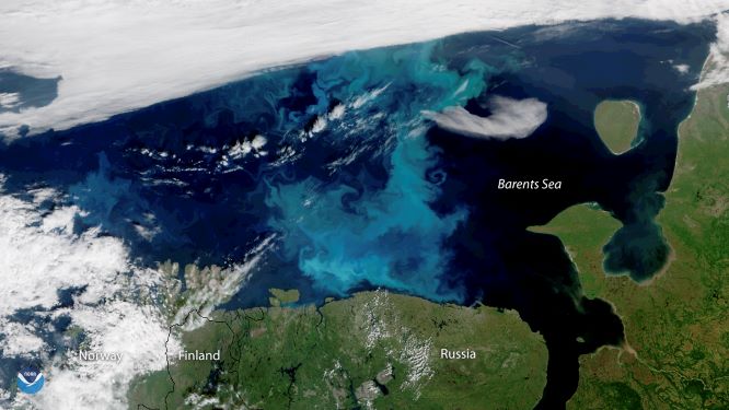
This
true-color image, captured by the NOAA-20 satellite on July 30,
2018, shows a large phytoplankton bloom in the Barents Sea. Credit:
NOAA Environmental Visualization Laboratory
The
decline in Arctic sea ice over the past several decades has made way
for areas of open water where phytoplankton can thrive, driving their
northward expansion, according to the study’s authors. The
researchers are unsure what effect this expansion will have on the
food web, but the results suggest the decline of ice cover is
impacting marine ecosystems in unforeseen ways.
If
sea ice continues to decline, it could drive phytoplankton spring
blooms farther north and increase primary productivity even more.
These changes could affect the fate of the Arctic Ocean as a carbon
source or a carbon sink, according to the study.
“If
the ice pack totally disappears in summer, there will be consequences
for the phytoplankton spring bloom,” said Sophie Renaut, a Ph.D.
student at Laval University in Quebec City, Canada, and lead author
of the new
study in Geophysical
Research Letters,
a journal of the American Geophysical Union. “We cannot exactly
predict how it will evolve, but we’re pretty sure there are going
to be drastic consequences for the entire ecosystem.”
Phytoplankton
in the ecosystem
Phytoplankton
are microscopic organisms that live in water, consume carbon dioxide
and release oxygen through photosynthesis. In this process, they
convert sunlight into chemical energy. Phytoplankton form the base of
the marine food web, indirectly feeding everything from small fish to
multi-ton whales.
Phytoplankton
growth depends on the availability of carbon dioxide, sunlight,
nutrients, water temperature and salinity, water depth and grazing
animals, according to the NASA
Earth Observatory.
When conditions are ideal, phytoplankton population growth can
explode, or bloom. While a bloom may last several weeks, the lifespan
of an individual phytoplankton is seldom more than a few days.
Phytoplankton
in the Arctic Ocean typically bloom every spring. In the past,
phytoplankton blooms have been virtually absent from the highest
Arctic latitudes, because these areas are usually covered by sea ice.
In recent decades sea ice has declined, breaking up earlier in the
spring or not forming at all in some areas of the Arctic.
In
the new study, Renaut and her colleagues wanted to see if recent sea
ice declines have had any effect on spring phytoplankton blooms. They
used satellite observations of ocean color—which provide estimates
of phytoplankton biomass and primary productivity—to track changes
of the blooms each spring from 2003 to 2013.
They
found the spring blooms are expanding farther north and increasing in
primary productivity. In the spring and summer months, net primary
productivity in the Arctic Ocean increased by 31 percent between 2003
and 2013, according to the study. The researchers also found that
these blooms in the Barents and Kara Seas, north of Russia, are
expanding north at a rate of 1 degree of latitude per decade.
Estimates
of annual trends in daily flux of primary productivity (PP) during
the phytoplankton spring bloom determined from satellite ocean color
data. Green pixels correspond to new phytoplankton spring blooms
observed since 2010. Credit:
S. Renaut et al. 2018
Unexpected
effects of sea ice decline
Sea
ice melt occurring earlier in the season creates larger open water
areas that act as incubators for phytoplankton growth and elongate
their growing season, according to Renaut.
The
authors suspect spring blooms could someday extend into the Arctic’s
central basin, which encompasses almost everything north of 80
degrees latitude.
Primary productivity, though, would likely remain
low due to a lack of nutrients. Less ice cover means spring blooms
and under-ice blooms may also have to compete for light and
nutrients, thus altering the flow of the marine ecosystem. The
results suggest a large change in this region, which has never been
free of ice cover.
“The
polar regions—the Southern Ocean and the Arctic Ocean—they’re
really important because they play a critical role in regulating the
global climate,” Renaut said. “If sea ice disappears completely
in summer in the Arctic Ocean, which is what we expect in some
decades, it’s going to have an impact on the ecosystem but also
likely on the climate.”
Patricia
Yager, professor of Marine Sciences at the University of Georgia who
was not involved with the new study, said the earlier algal bloom
growth they observed in some areas could have considerable impacts if
animals are not yet ready to graze on the phytoplankton.
“Such
a mismatch in time could cause major changes to the Arctic food web,
impacting not only the local animals and the people who live there,
but also the global population of migrating animals who depend on
these Arctic resources,” Yager said. “What happens in the Arctic
does not stay in the Arctic.”
Cecile
Rousseaux, a research scientist at the Universities Space Research
Association, who was not involved in the new study, said the study
advances research in this area by investigating individual regions of
the Arctic for phytoplankton productivity, and represents evidence of
the effects that reduced ice cover have on the biochemical cycle of
the Arctic Ocean. However, Rousseaux noted that the study does have
limitations.
“It
is also important to remember that we are currently limited by the
amount of data available to study these changes,” Rousseaux said.
“Longer time series of satellite data will allow us to confirm
whether these trends in phytoplankton productivity persist or not.”
Authors:
Sophie
Renaut, Marcel Babin: Takuvik
Joint International Laboratory, CNRS, Laval University, Québec,
Québec, Canada;
Emmanuel
Devred: Takuvik
Joint International Laboratory, CNRS, Laval University, Québec,
Québec, Canada and Ecosystem and Ocean Sciences Division, Bedford
Institute of Oceanography, Department of Fisheries and Oceans,
Dartmouth, Nova Scotia, Canada
Slow
melt rate appears on the verge to take a dive
~JAXA
45,000 km2 August 23-24 drop looks kind of smallish low melt rate
appears on the verge to take a dive0 km2 August 23-24 drop looks kind of smallish
JAXA
loop August 23-24 , 24 is with the darker sea ice areas, has
some very interesting aspects, namely vast regions appearing
to have much more open water, but the drop was officially
45K.
However, observe North of Wrangle Island vast
area much larger than 100 K turning almost completely blue,
here is a good example of the 15% per 16 km square grid rule
confusing matters,
but
if the trend continues, these grids will eventually drop with ice
content below 15%, and cause quite a remarkable daily drop.
Which again will not be a huge area of sea ice suddenly
melting, but would be the result from a long protracted melt
and mixing process.
Even with this 15% rule, the
darkening of what is left of the other very large areas of the pack,
signifying more open water, didn't really show up with extent
numbers, therefore patience is required along with judgment
when considering 2018 melt rates. WD August 25,2018
P.S This is the latest from NASA. There is a lot of cloudcover
Yesterday
Margo did a very thorough sea ice update.
If
you are short on time skip to approximately the 30 minute mark.
If
you are even more short on time you can read my partial synopsis
below.
Arctic
Sea Ice Update & Climate Cast with Margo - August 18, 2018
Margo
had the insight that you could use a layer giving the temperature of
ice to see areas where temperatures are above freezing.
The
other interesting point was that you can use the tool to determine
those areas where there is no cloud cover as they are unable to
measure the ice temperature where there is cloud cover.
"Any
pixel that has a temperature of less than 271.5K is considered to be
ice and any pixel with a temperature of 271.5K is considered to be
open water.
Any
pixel that has a temperature of less than 271.5K is considered to be
ice and any pixel with a temperature of 271.5K is considered to be
open water.....
During
the “warm period” during the summer period melting snow or any meltponds will likely have temperatures of melting fresh water
(273.15K) because it meltwater on the surface of multiyear ice floes
is less saline than water on top of first-year ice since salts are
ejected when an ice floe survives long enough to become a multi-year
floe
To translate:
In
thick water, such as north of Canada the ice has more fresh water
The
thinner ice is more saline and melts at a lower temperature.
This
is what can be seen in such an area near the Pole.
Margo
goes into this in greater detail in her video.
That
dark area may be a meltpond or, with the ice being so thin, we may be
seeing blue water through a thin layer of ice.
Margo
then went into the huge increase of methane emissions around the
world but particularly in the Arctic.
We
are also seeing this in the East Siberian Arctic Shelf (ESAS)
Arctic
sea ice is ebbing faster than normal, and by September it could
bottom out at a very low level
By
Tom Yulsman
This
animation consists of false-color images of the Russian coast
and adjoining East Siberian Sea acquired by NASA’s Aqua satellite.
On June 18, the offshore waters were choked with sea ice. By
July 6, 2017, a lot of it had broken up. In the false-color scheme,
land is green, black is indicative of open water, and ice is a
light turquoise. The darker blue prominent in the June 18th
image probably is indicative of melting snow and ice
that’s causing liquid water to accumulate. (Images: NASA
Worldview. Animation: Tom Yulsman)
Under
frigid winter conditions, the Arctic’s floating lid of sea ice
typically expands to a maximum extent in March. But thanks
to human-caused global warming, that maximum seasonal spread of
the ice has been shrinking over the years — and this past
March it reached the lowest
level ever
observed for the month.
But
then, something unexpected happened: In May, sea ice retreated much
more sluggishly.
This
prompted some people who deny the reality of humankind’s impact on
the climate to pounce. “ARCTIC SEA ICE BOUNCES
BACK,” shouted one
headline (on
a blog that bills itself as being dedicated to “common sense
on climate change”). Well, hold on…
Now
we have the monthly report from
the scientists at the National Snow and Ice Data Center, and wouldn’t
you know it: During June, Arctic sea ice shrank faster than average.
That resulted in June’s ice cover coming in at sixth lowest in
the satellite monitoring era, which began in 1979.
But
that’s not the most newsworthy part of the report. In my view, this
is: By July 2, Arctic sea ice had retreated to a
particularly low level matching what was seen on the same date
in 2012.
That’s
significant because in 2012, sea ice went on to set a record
that has not been broken since. During the summer of that year,
ice extent dropped precipitously, and in September it went lower
than ever seen before.
A
comparison of true-color and false-color images acquired by the Aqua
satellite on June 18, 2017 in the same area as shown in the
animation at the top of this post. Note the likely melt ponds, which
contribute to the break up of sea ice. (Images: NASA Worldview.
Animation: Tom Yulsman)
Of
course, just because Arctic sea ice melted relatively fast in June
and is really low now doesn’t mean it will set a new record this
coming September. But given the conditions in the Arctic
right now, the odds are good that the sea ice extent minimum
will be very low.
How
low? It’s impossible to know for sure at this point. But scientists
of the Sea Ice Prediction Network do their best to make
informal forecasts. For their June
report,
they analyzed predictions from 33 different sources.
According to the report, the median forecast is for Arctic sea ice
extent to bottom out in September at 4.43 million square
kilometers. That would put it in the top five of lowest extents on
record.
That
relatively low number probably reflects a number of factors. One is
temperature — specifically, how cold has it been in the Arctic and
for how long?
Source:
NSIDC
This
is gauged by something called cumulative freezing degree days. This
is the sum of daily mean temperatures below freezing over a
particular period.
Based
on this metric, between July of last summer and July of this year,
the Arctic has been “extremely mild,” according to the NSIDC
report. Do keep in mind that this is a relative statement. It
is a specific comparison to a base period of 1981 to 2000.
You
can see just how relatively mild it has been by clicking on the
graphic above. From July of 2016 to now, the period has been milder
than the same period in 2012, the year Arctic sea ice
hit its lowest extent on record.
The
relative dearth of days with below freezing temperatures has taken a
toll on the sea ice. Across the Arctic, it is thinner than
average, according to an analysis by the University of
Washington’s Pan-Arctic
Ice Ocean Modeling and Assimilation System, or PIOMAS.
The
image above shows what’s happening. Areas in blue
indicate areas where Arctic sea ice is thinner than the 2000 to
2015 average. And as the graphic shows, sea ice thicknesses for
May 2017 were below average over most of the Arctic Ocean. (The
exception: the red areas north and west of the Svalbard archipelago.)
The scrawny
ice cover will make it easier for warm summer temperatures to
melt the ice. As the June NSIDC report states, “Starting the melt
season with below-average ice thickness raises the likelihood of
having especially low September ice extent.” Time will tell.
The
main thing that I get from the news reports below is how quickly the
situation is deteriorating and we are set to see ice-free conditions
in the Arctic by August and the satellite monitoring this is going
blind so we will be blind.
The
ensuing crop failures will of course be ‘worse than previously
expected’
Climate
& Extreme Weather News (June 1st to June 3rd 2017)
Domes
of frozen methane may be warning signs for new blow-outs
Several
methane domes, some 500m wide, have been mapped on the Arctic Ocean
floor. They may be signs of soon-to-happen methane expulsions that
have previously created massive craters in a near-by area.
500m wide and 10m high, the
methane domes on the Arctic Ocean floor are containing huge amounts
of methane. Illustration: Pavel Serov/CAGE Credit: Pavel Serov/CAGE
"Every
year we go back to the dome area
with our research vessel, and every year I am anxious to see if one
of these domes has become a crater,"
says lead author of the study Pavel Serov, PhD candidate at CAGE at
UiT The Arctic University of Norway.
These
domes are the present-day analogue to what scientists think preceded
the craters found in the near-by area, which were recently reported
in Science.
The craters were formed as the ice sheet retreated from the Barents
Sea during the deglaciation some 12.000 years ago.
At
the time, 2km thick ice-cover loaded what now is the ocean floor
with heavy weight. Under the ice
sheet the
methane became stored as hydrate,
a solid form of frozen
methane.
"We
believe that one step before the craters are created, you get these
domes. They are mounds of hydrates, technically we call them gas
hydrate pingos. They are hydrate and methane saturated relics of the
last ice-age. They haven't collapsed yet. And the reason is a matter
of narrow margins" states Serov.
20
meters from the brink of collapse
The
dome area is situated on the Arctic Ocean floor just north of the
craters. It is deeper, but not by much. The domes are found some 20
meters deeper. Essentially the height of the Buckingham Palace keeps
these methane domes from blowing out the gas and becoming craters.
"Hydrates
are stable in low temperatures and under high pressure. So, the
pressure of 390 meters of water above is presently keeping them
stabilised. But the methane is bubbling from these domes. This is
actually one of the most active methane seep sites that we have
mapped in the Arctic Ocean. Some of these methane flares extend
almost to the sea surface" says Serov.
He
is reluctant to speculate as to how much methane may
be released into the ocean should the domes collapse entirely and
abruptly. It is not possible to predict when it may happen either.
But every sediment core collected in the area is full of hydrates.
This
is actually the first time that domes such as these have been found
outside of the permafrostareas.
More
stable than in permafrost
However
unstable these domes on the Arctic Ocean floor may be, they are still
more stable than the pingos found in sub- sea permafrost in Canadian
and Russian Arctic.
"The
gas hydrate pingos in permafrost are formed because of the low
temperatures. But the water-depth that supports gas hydrates in
sub-sea permafrost is only 40 to 50 meters. There is no significant
pressure there to keep them in check. Sub-seabed permafrost is
deteriorating constantly and quickly" notes Serov.
Even
though they are more stable than the permafrost pingos, the Barents
Sea domes are on the limit of their existence.
"A
relatively small change in the water temperature can destabilise
these hydrates fairly quickly. We were actually very lucky to observe
them at this point. And we will probably be able to observe
significant changes to these domes during our lifetime."
Global
warming is edging perilously close to out-of-control, according to a
growing number of scientific reports from round the planet, a leading
science writer has warned.
"Time
is running out if we want to preserve our world in a stable, healthy
and productive state, capable of feeding and supporting us all,"
says Julian Cribb, author of Surviving the 21st Century, a book on
the ten greatest challenges facing humanity and what we can do about
them.
"The
great concern is the rapid rise, over the last three years,
in methane levels
in the atmosphere. Methane is a gas with 28 times the planet-heating
power of carbon dioxide. Scientists estimate there may be as much as
5 trillion tonnes of it locked in permafrost and seabed deposits.
"There
is mounting evidence that, as the planet warms due to human activity,
these vast reserves of greenhouse gas are now starting to melt and
vent naturally. The Earth's past history shows this could unleash
runaway global
warming,
driving up planetary temperatures by as much as 9 or 10 degrees
Celsius.
"At
such temperatures, some scientists consider there is a high risk the
planet would become uninhabitable to humans and large animals,"
Mr Cribb says.
"Runaway
heating and nuclear war are the two most likely triggers for human
extinction – and it is time everyone took them both a lot more
seriously."
Reports
of methane escaping into the atmosphere have been growing steadily,
ever since a group of students demonstrated the risks by setting fire
to venting Arctic gas in 2008. However, scientists report a sudden
surge in global methane emissions in the last three years, 2014-16.
"So
far the rise in methane has been attributed mainly to cattle raising,
rice farming and gas extraction – but there is now disturbing
evidence that more gas is emerging from Arctic soils as the
permafrost melts, and from the seabed where methane has been trapped
as ice for millions of years.
"Russian
scientists have reported the discovery of thousands of potential
'methane-bombs' – frozen gas-filled mounds – across Siberia,
primed to erupt as the ground thaws out.
"Swedish
scientists have observed the waters of the Artic oceans 'fizzing like
soda water' as the ocean waters warm, causing frozen seabed methane
to turn back into gas and erupt."
Mr
Cribb says that so far humans have released about 2 billion tonnes of
CO2, which has warmed the planet by one degree C. By 2040, we will
release another billion tonnes and push the planet's temperature up
by 2 degrees or more.
"This
we can possibly control, by cutting back on our use of fossil fuels
and by ceasing to burn coal," he says. "However, there is
no way to stop the methane venting naturally from the seabed and
permafrost once it starts – and there are potentially 5 trillion
tonnes of it.
"This
phenomenon is known to scientists as the 'clathrate gun'. If it
fires, the fate of the entire human species is in question."
Mr
Cribb said that technical difficulty in measuring the Earth's natural
methane emissions and estimating the size of its reserves has until
now led to the gas being discounted, or downplayed, in warnings about
dangerous climate
change by
the Intergovernmental Panel on Climate Change and other agencies.
"That
time is over. We are now witnessing early warning signs of major
methane release. If it gets out of control, there will be nothing
humans can do to prevent the planet overheating quite rapidly."
Mr
Cribb said it was more urgent than ever that governments and
corporations of the world unite to combat climate change. "The
recent Climate Turning Point report says the world has until 2020 –
just two and a half years – to reverse global
carbon emissions by
cutting fossil fuel use. Time is running out – and the methane gun
makes matters all the more urgent.
"This
means that countries like America and Australia have to cease their
dangerous do-nothing policies, countries like India and China need to
stop building coal-fired power stations immediately – and every
country and business needs to make a far greater effort to scale back
its carbon emissions.
Surviving
the 21st Century (Springer International 2017) is a powerful new book
exploring the main risks facing humanity: ecological collapse,
resource depletion, weapons of mass destruction, climate change,
global poisoning, food crises, population and urban overexpansion,
pandemic disease, dangerous new technologies and self-delusion –
and what can and should be done to limit them.
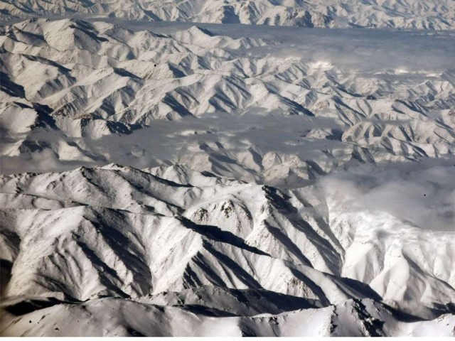
Owing
to climate change, the probability of permafrost resources melting in
Hindu Kush and Himalaya has increased. This not only intensifies
incidents such as Glacial Lake Outburst Flood (GLOF) but would also
affect natural streams and springs in the northern parts of the
country.
“Though
there is a very little knowledge about permafrost in Pakistan,
recently, a number of permafrost were found in the Karakorum mountain
range near Khujerab along the Karakorum Highway (KKH),” an
official at the Pakistan Meteorological Department (PMD) told The
Express Tribune.
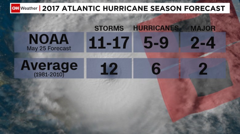
Hurricane
season began on June 1, and according to the National Oceanic and
Atmospheric Administration, the season will be a busy one, with an
above-average range of 5-9 hurricanes likely in the Atlantic.
The
United States could be especially vulnerable to hurricane landfalls
this year, observers say, but not because of the enhanced activity
that is expected.
The
two agencies that protect the country's coast lines and its
residents, NOAA and the Federal Emergency Management Agency (FEMA)
are still without leaders -- positions that must be appointed by
President Donald Trump and confirmed by the Senate.
"That
should scare the hell out of everybody," retired US Lt. Gen.
Russel Honoré told CNN. "These positions help save lives."
Michael
Oppenheimer, a Princeton scientist and longtime observer of UN
climate talks, says that the world has lost its last shot at staving
off dangerous global warming.
Councils
are going to be told not to build or approve developments or
structures lower than 1.9 metres above the high tide mark under new
advice on rising sea levels.
It's
a half-metre increase on the Ministry for the Environment's previous
advice a decade ago, based on new information showing sea levels will
rise faster than anticipated.
Bulging
bumps in the Yamal and Gydan peninsulas believed to be caused by
thawing permafrost releasing methane.
Scientists
have discovered as many as 7,000 gas-filled 'bubbles' expected to
explode in Actic regions of Siberia after an exercise involving field
expeditions and satellite surveillance, TASS reported.
A
number of large craters - seen on our images here - have appeared on
the landscape in northern Siberia in recent years and they are being
carefully studied by scientists who believe they were formed when
pingos exploded.
Alexey
Titovsky, director of Yamal department for science and innovation,
said: 'At first such a bump is a bubble, or 'bulgunyakh' in the
local Yakut language.
'With
time the bubble explodes, releasing gas. This is how gigantic funnels
form.'
An
algae bloom the size of Mexico has appeared in the Arabian Sea,
thanks to a growing 'dead zone' in the Gulf of Oman.
It's
not the first time the build-up of green slime has appeared during
the winter months, but the bloom now stretches all the way from the
shores of Oman on the west, to India and Pakistan on the east,
turning the waves "almost guacamole-like", according to a
NASA biologist. And it's not a good sign for the local ecosystem.
A
long-growing crack in the Larsen C ice shelf, one of Antarctica’s
largest floating platforms of ice, appears to be nearing its endgame.
Researchers
with Project MIDAS, working out of Swansea University and Aberystwyth
University in Wales and studying the shelf by satellites and through
other techniques, have released an update showing that the crack grew
a stunning 11 miles in the space of just one week between May 25 and
May 31. It now has just 8 miles to go before an iceberg roughly the
size of Delaware breaks free into the Southern Ocean.
“There
appears to be very little to prevent the iceberg from breaking away
completely,” the researchers write.
Elsewhere
in their post, they note that the crack has curved toward the front
of the ice shelf and the ocean, meaning that the time when a major
break could occur “is probably very close.”
K.
Andreassen1,*, A. Hubbard1, M. Winsborrow1, H. Patton1, S.
Vadakkepuliyambatta1, A. Plaza-Faverola1, E. Gudlaugsson1, P. Serov1,
A. Deryabin2, R. Mattingsdal2, J. Mienert1, S. Bünz1
Abstract
Widespread
methane release from thawing Arctic gas hydrates is a major concern,
yet the processes, sources, and fluxes involved remain unconstrained.
We present geophysical data documenting a cluster of kilometer-wide
craters and mounds from the Barents Sea floor associated with
large-scale methane expulsion. Combined with ice sheet/gas hydrate
modeling, our results indicate that during glaciation, natural gas
migrated from underlying hydrocarbon reservoirs and was sequestered
extensively as subglacial gas hydrates. Upon ice sheet retreat,
methane from this hydrate reservoir concentrated in massive mounds
before being abruptly released to form craters. We propose that these
processes were likely widespread across past glaciated petroleum
provinces and that they also provide an analog for the potential
future destabilization of subglacial gas hydrate reservoirs beneath
contemporary ice sheets.
Space
pictures show the blue-tinted lakes formed in depressions caused by
thawing permafrost on the Yamal and Gydan peninsulas.
A
feature of these thermokarst lakes are craters or funnels in the
sediment on the floor through which they are haemorrhaging methane.
These pockmarks are similar to those found on the floors of the great
oceans.
Scientists
say these leaks are year round in lakes where carbon processing and
methane emission occur even at temperatures close to zero degrees
Celcius. Detailed study of satellite data from 2015-16 has identified
more than 200 lakes which are seen as an active source of methane
emissions.
The
gas is of both a biochemical nature, the result of microbial activity
released by permafrost thawing, and catagenesis, formed in deep
ground layers.
Professor
Vasily Bogoyavlensky, deputy director of the Moscow-based Oil and Gas
Research Institute, part of the Russian Academy of Sciences, said:
'These lakes have a number of features, which can help identify them
from a distance: the anomalous blue colour of water, the presence of
craters on the bottom and gas seeps in the water, the traces of gas
in the seasonal ice cover, as well as active coastal erosion and
permafrost swelling near the water's edge.'
The
sulphur in the gas leaks results in algae flourishing in these Arctic
waters, which give the lakes their distinctive hue. He warned that
'many of the sites with gas emissions are located close to the
territory of oil and gas deposits'
Moreover,
he sees an 'interrelation of gas emissions and seismic activity. 'For
example, over one of the gas deposits (in Yamal), lakes are located
along two lines ... looking like a giant cross'.
This
suggests a 'genetic connection of craters with deep faults in the
earth's crust, but to confirm we need to conduct thorough seismic
research'.
His
work in highlighting the lakes with bubbling methane follow
revelations this week of several thousand pingos, some of which are
filled with gas which could 'explode' forming giant craters - as seen
in pictures here. At least 10 craters are known about caused by such
eruptions.
Scientists
say it was wrong to call these pingos 'gas bubbles'. Nor are all
pingos in this region susceptible to explode.
Pingos
are dome-shaped mounds over a core of ice, and they can erupt under
pressure of methane gas released by the thawing of permafrost caused
by climate change.
Alexey
Titovsky, director of the Department of Science and Innovation in
Yamal-Nenets autonomous region, said: 'All the pingos revealed in
Yamal are now monitored and in the coming summer the scientists will
study them more closely. 'One
of the most important things for us it to understand how they
appear, to develop a method of detection of such formations. It is
also important to understand what is inside such mounds.
'There
can be gas, water, ice - anything. We need to know precisely in order
to make forecast.
'Sadly
the study of the crater that appeared in 2014 near Bovanenkovo does
not give us the precise answer as to what exactly was inside the
pingo that preceded this crater. When we understand what is inside
the pingos, we can predict how dangerous they are.'
Dr
Marina Leibman, an expert from the Institute of Earth Cryosphere,
Russian Academy of Sciences, said 'Last year in Yamal there was a
very warm summer season.
'As
a result, the expeditions of 2017 will be aimed at assessing the
changes associated with this warming. There is a possibility of the
activation of these cryogenic processes. Obviously, the area of
thermocircuits will increase. The temperature of rocks and the depth
of seasonal thawing will increase.'
But
the scientists say they 'refute' the term 'underground gas bubbles'.
They have never encountered such a natural phenomenon.
'All
the cryogenic processes which occur on the peninsula are well studied
and have scientific explanations,' said a statement. 'All of them are
the subject of ongoing scientific monitoring.
'It
should be added that 'gas bubbles' is used in common language for
another unusual phenomenon, recorded in July 2016 on the Bely Island,
when an abnormally hot summer resulted in thawing permafrost and
swelling the turf.... Scientists counted only a dozen of such small
'bubbles' on the surface.'
Humans emit roughly 30 to 40 billion tons of the greenhouse gas, carbon dioxide, into the atmosphere each year. If we keep it up, Earth will continue to heat up and ultimately devastate our way of life.
So what can we do about it?
Most scientists agree that we need a way to capture some of that CO2 out of the atmosphere. One idea is to plant lots of trees. Trees use CO2 in order to grow. They also release oxygen, so it’s a win-win.
But recent reports indicate that we simply can’t grow enough trees to capture the necessary amount of CO2 that would help us meet the goals set by the Paris Agreement.
Living in the Canadian Arctic regions, Greenland and the USA, the Inuit people and their ancestors were all fantastic weather forecasters.
NASA has received a warning from the Inuits, that warning is about climate change, but it isn’t because of global warming, it’s due to the Earth shifting! They reported that the earth has shifted or rather, wobbled and say that their sky has changed!
Elders have noted that the sun has been rising in a different position and that their daylight hours for hunting have been prolonged, as well as temperature rising more rapidly.
The Inuits have also stated that not only the sun has changed position but also the moon and stars, and they all have an effect on temperature and wind which makes weather prediction trickier The following illustrates the continuing saga of sea ice melt and high temperatres at the North Pole
sometime
around this August or September the summer ice in the Arctic will be
gone for the first time in over 3 million years and the satellite
program monitoring the situation goes blind.

 Posts
Posts