Posts
Posts


Jeff
Rense cited the article below in his discussion with Dane Wigington.
Jeff
and Dane Wiggington - Linked...GeoEngineering And The Disastrous CA
Fires
Watch Hurricane Lane Be Destroyed By HAARP-Like EMF Just Before It Was To Hit US Military Bases On Oahu - Photos
26 August, 2018
Like most of us, I have watched hurricanes via aerial and satellite photos all my life. Huge, masses of moisture, wind and POWER spiraling counterclockwise (reverse in the Southern Hemisphere) and often doing enormous damage when these monsters make landfall.
How big was Hurricane Lane? How large was the danger posed to the US Military on and around Oahu? It was SO large, there was a highest level US Navy alert and warning issued a couple days before Hurricane Lane was due to slam into Oahu… potentially causing hundreds of millions in damage to military installations which control the entire Asia Pacific theater.
The Alert instructed all military personnel to make plans to either get out or to prepare to shelter in place. This was not a joke to US Naval Command.
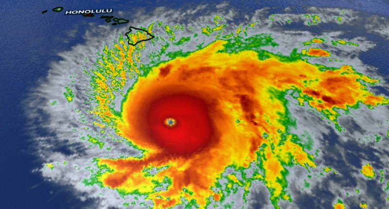
Below is a satellite image of the hurricane with the eye clearly located in the center of the spinning storm with winds of over 150 mph. This meant big trouble for Hawaii military bases and civilian populations alike.
How big was Hurricane Lane? How large was the danger posed to the US Military on and around Oahu? It was SO large, there was a highest level US Navy alert and warning issued a couple days before Hurricane Lane was due to slam into Oahu… potentially causing hundreds of millions in damage to military installations which control the entire Asia Pacific theater.
The Alert instructed all military personnel to make plans to either get out or to prepare to shelter in place. This was not a joke to US Naval Command.
Below is a satellite image of the hurricane with the eye clearly located in the center of the spinning storm with winds of over 150 mph. This meant big trouble for Hawaii military bases and civilian populations alike.
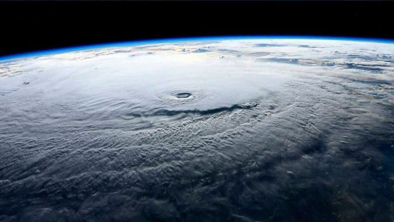
Here is the actual very high level US Navy Urgent Alert regarding Hurricane Lane….
From: COMPACFLT,
Subject: Directorate Quarters Notes
IMPORTANT INFO FROM NAVY REGION REGARDING HURRICANE LANE
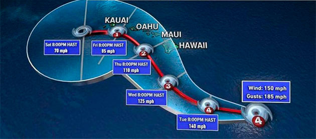
▲ Hurricane Lane is expected to make landfall Friday @ 1500 as a Category 4 Hurricane. Current models have it hitting Hickam Beach directly.
▲ Officials expect (worst case) tidal surges up to 15 feet high on Joint Base Pearl Harbor-Hickam.
▲ We are currently at Topical Cyclone Condition of Readiness (TCCOR) 3.
▲ Expect shift to TCCOR 2 Thursday morning.
▲ Expect shift to TCCOR 1 Thursday afternoon or Friday morning.
TCCOR 3: Destructive Winds are possible within 48 hours.
TCCOR 2: Destructive winds are anticipated in 24 hours.
TCCOR 1: Destructive winds are anticipated within 12 hours.
**A more descript breakout of TCCORs can be found in the attachments.**
▲ Those living on base need to ensure they are back on base prior to TCCOR 1 being set, or they will NOT be let on.
▲ Joint Base Pearl Harbor-Hickam (to include Ford Island and NCTAMS) will be locked down during TCCOR 1 and will not reopen until Saturday morning.
▲ The Ford Island bridge will be closed whenever winds reach 50 knots or greater.
▲ Ports of Hawaii are now shutdown (no food, supplies, etc. will come in for upwards of 7 days from now).
▲ Public schools will close after school today (Wednesday).
▲ If you do not have 3 days worth of non-perishable food and water you need to get that tonight.
▲ Should cell/cable/internet services go down, you can get important updates on the radio at 92.3 FM
▲ Those living on base down island should try to park their cars in an elevated parking garage or parking lot.
▲ Expect Command and Operational recalls over the course of the next three days. Keep your phone on you or near you and notify someone if you will be away from your phone for an extended period of time.
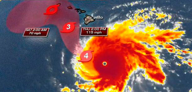
Here is an overhead photo of the storm showing the Islands clearly in harm’s way. Lane was a textbook classic hurricane if there ever was one.
From: COMPACFLT,
Subject: Directorate Quarters Notes
IMPORTANT INFO FROM NAVY REGION REGARDING HURRICANE LANE
▲ Hurricane Lane is expected to make landfall Friday @ 1500 as a Category 4 Hurricane. Current models have it hitting Hickam Beach directly.
▲ Officials expect (worst case) tidal surges up to 15 feet high on Joint Base Pearl Harbor-Hickam.
▲ We are currently at Topical Cyclone Condition of Readiness (TCCOR) 3.
▲ Expect shift to TCCOR 2 Thursday morning.
▲ Expect shift to TCCOR 1 Thursday afternoon or Friday morning.
TCCOR 3: Destructive Winds are possible within 48 hours.
TCCOR 2: Destructive winds are anticipated in 24 hours.
TCCOR 1: Destructive winds are anticipated within 12 hours.
**A more descript breakout of TCCORs can be found in the attachments.**
▲ Those living on base need to ensure they are back on base prior to TCCOR 1 being set, or they will NOT be let on.
▲ Joint Base Pearl Harbor-Hickam (to include Ford Island and NCTAMS) will be locked down during TCCOR 1 and will not reopen until Saturday morning.
▲ The Ford Island bridge will be closed whenever winds reach 50 knots or greater.
▲ Ports of Hawaii are now shutdown (no food, supplies, etc. will come in for upwards of 7 days from now).
▲ Public schools will close after school today (Wednesday).
▲ If you do not have 3 days worth of non-perishable food and water you need to get that tonight.
▲ Should cell/cable/internet services go down, you can get important updates on the radio at 92.3 FM
▲ Those living on base down island should try to park their cars in an elevated parking garage or parking lot.
▲ Expect Command and Operational recalls over the course of the next three days. Keep your phone on you or near you and notify someone if you will be away from your phone for an extended period of time.
Here is an overhead photo of the storm showing the Islands clearly in harm’s way. Lane was a textbook classic hurricane if there ever was one.
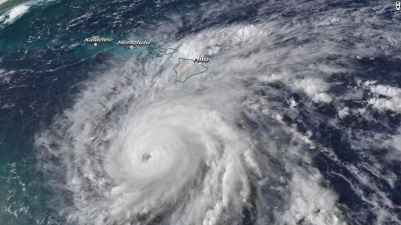
Below is another satellite image more clearly showing the massive spinning and power of Lane as it was about to move NNW up past the Big Island and toward Oahu and all the sensitive military installations there Including nuclear weapons bunkers.
Notice the eye of the hurricane is quite pronounced and surrounded by the150 mph winds powering the spiraling rotation of the big storm.
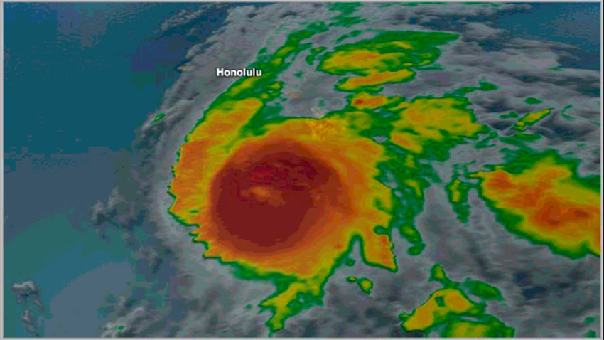
The next image below shows Hurricane Lane moving past the Big Island of Hawaii after dumping over 30 inches of rain on it.
However, note carefully how slow the spiraling rotation of the storm had suddenly become. It was now barely spinning and presents more like a large blob of intense moisture. The eye is nearly gone now.
The huge (red-orange) storm continued to crawl straight north, directly toward Honolulu, when something caused it to essentially slow to a near stop immediately south and offshore of Oahu. It was as if it had been parked there just before it would have scored a direct hit on Oahu…exactly like the highest level US Navy Alert warned it would do. The once tightly-defined spinning shape of the hurricane is gone and it is now seen oozing large amounts of moisture up and to the right in the photo…
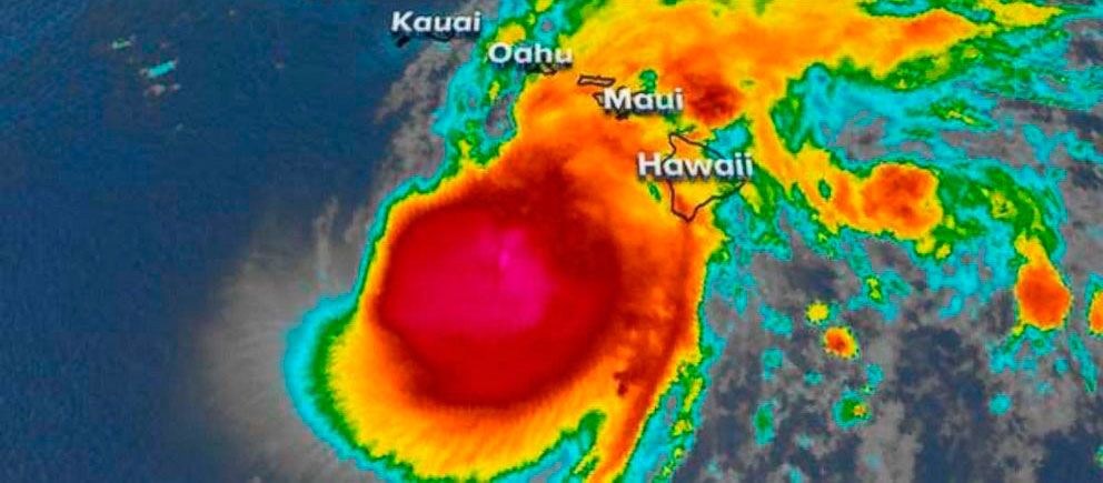
Then something extremely stunning happened…or was MADE to happen. This intense, powerful storm slowed to a virtually halt as it moved due north toward the all-important island of Oahu...bristling with Army, Navy and Air Force bases…and nuclear weapons.
It took a long time and a little luck to find this particular video frame below which shows blatant proof of extreme EMF military-government weather control.
Now see what has happened…it was as if a gigantic boot came down right on the top of Hurricane Lane. The ‘boot' was, of course, an electromagnetic GeoEngineered HAARP-like BLAST of EMF which crushed the hurricane to pieces.
Have you EVER seen a hurricane suddenly STOP SPIRALING, sit perfectly still and then be smashed with enormous energy from above? Look below…now you have have.
Look again at the preceding photo ABOVE and then look back down at the photo BELOW…your eyes don’t lie…
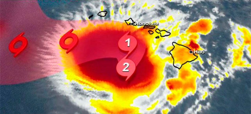
Most of all, LOOK at the radiating white, strangely jagged ‘fingers’ or ‘rays’ sticking out from all around the perimeter of the big (red) storm center. Especially on the left and top sides.
LOOK CLOSELY and you’ll see how these ‘fingers' are shaped exactly like the blade of a saw! That is NOT naturally possible. That is EMF weather control.
Further, they are all pointing straight outward at essentially 90 degree angles from the perimeter of the massive amount of moisture (red) the storm was still carrying. Hurricane Lane, like a squashed bug, is no longer showing any signs of spiraling. In fact, the more you look at the bottom left section of the (red) storm center, the more crazy, bizarre things you see!
You are looking at the almost instant results of a violently powerful EMF weather ‘bomb’ used, in this case, to destroy a hurricane to protect scores of sensitive, critical military facilities on Oahu. Read the Highest Level US Navy warning again.
Apparently, a (Pentagon) decision was made to protect the military nerve center of the Asia Pacific Theater from the potentially major damage of Hurricane Lane…even at the risk of revealing the incredibly-advanced weather control technology the Military and Deep State possess. It was a calculated risk…’they’ were hoping no one would notice the unprecedented and bizarre ‘behavior’ and demise of what had been a Cat 4 Hurricane just 24 hours earlier. This particular video frame proves that our weather is in the firm control of the military industrial congressional media complex.
Below is a second look at the same image. Do you see ANY evidence of a SPIRALING HURRICANE? No, none. There is no more spin or spiraling or any substantial wind. The big storm was brought to a complete stop...shutting down the spiraling winds…and then Hurricane Lane was essentially annihilated.
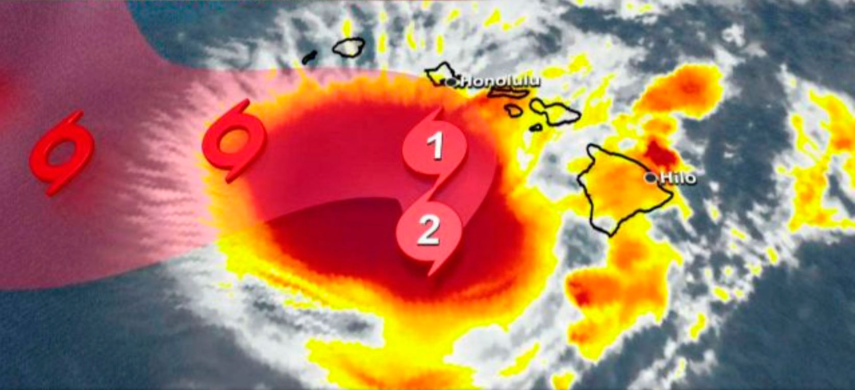
Look now at the shattered wreckage of Hurricane Lane below and see for yourself ...
Notice the outer ‘ring' on the left and bottom where the EMF energy cut through the intense red body of moisture of the storm. Where did all the red moisture (rain) go? It probably fell straight down into the ocean below it.
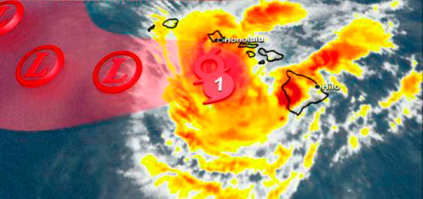
The time involved in destroying Hurricane Lane was just a matter of minutes. The danger to the US Military was immediately nullified. And the world was none the wiser…except for those who already know the technology of weather control is enormous and absolutely real. Hurricanes can be started and stopped. Weather systems the same. Remember how Katrina took that bizarre right turn and was driven directly into New Orleans? No accidents…no coincidences…
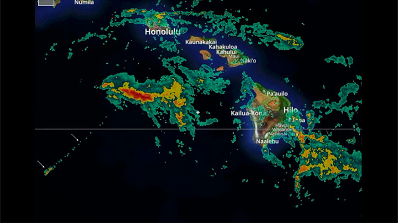
Here now is one final satellite photo in different color mode which shows the crushed, destroyed pieces of Hurricane Lane. This last photo evidence of EMF weather control also reveals a bizarre completely straight line at about the 7:30 position on the clock. Look down to the left end of this ‘clock hand’ and you will see two TINY rectangular rain cells. Not natural. No chance. The USAF boast about ‘controlling the weather by 2025’ is already a done deal.
- Jeff Rense
You
might also remember that several years ago, as we reported with
satellite proof, how storm after storm coming across the Pacific,
from West to East, were crushed before making it to CA, OR and WA in
very similar fashion. Go here for a
look…. https://rense.com/general96/pacstorms.html