Thursday, 1 March 2018

Sudden Stratospheric Warming and Polar Amplification

Sudden Stratospheric Warming and Polar Amplification: How Climate Change Interacts With the Polar Vortex

28 February, 2018

Over the past few years, the term Polar Vortex has dominated the broadcast weather media — gaining recent notoriety due to increasingly extreme weather events associated with a number of disruptions to Arctic atmospheric circulation patterns. In short, this swirl of cold air over the furthest north regions is being intensely disrupted by warm air invasions — both at the surface and in the upper levels of the atmosphere. A subject that we’ll explore further as part of this analysis.
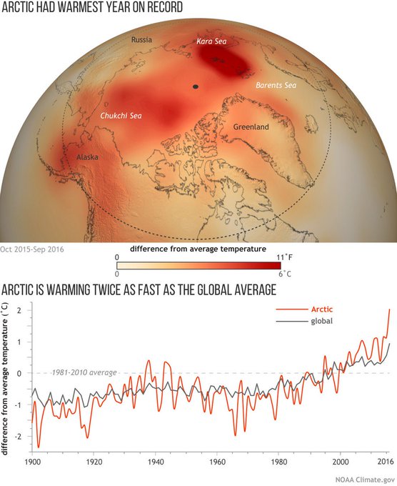
When it’s warmer at the pole than in Europe, it’s a sign that the weather is clearly out of whack. Especially when temperatures in a region spanning tens of thousands of square miles over the Arctic rocket to between 40 and 63 degrees Fahrenheit above normal. Scientists are notably concerned. Dr. Michael Mann, one of the world’s foremost experts on climate change characterized the polar warming event as:
…an anomaly among anomalies. It is far enough outside the historical range that it is worrying — it is a suggestion that there are further surprises in store as we continue to poke the angry beast that is our climate.
But what’s driving all this? Dr. Mann gives us a bit of a hint by describing our climate as an angry beast that’s being poked.
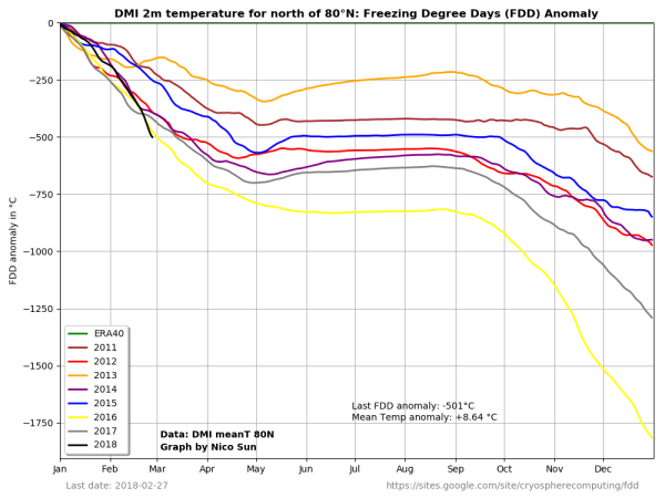
(Polar Amplification writ large. The entire region of the Arctic above the 80 degree North Latitude line has been 8.64 degrees Celsius warmer than normal for all of 2018 thus far. This is an extraordinary departure for a region that plays a critical role in how the Earth’s climate system functions. Image source: DMI.)
Perhaps another way to say it is that it’s a warming atmosphere that’s prodding the Jet Stream to take a chunk out of the Polar Vortex.

How might this work?

First, surface warming in the Arctic caused by increased radiative forcing from rising greenhouse gas levels and by follow-on reductions of Arctic sea ice and snow result in less temperature difference between the Pole and the Equator. This surface warming translates into higher levels of the atmosphere through convection.
Temperature difference is what drives the upper level winds. So a lower difference in temperature causes these winds to slow. When the Jet Stream winds slow, they tend to meander — forming large ridges and deep troughs. The elongated ridges and troughs eventually break like waves — pushing against the circulation of the Polar Vortex.

(NOAA graphic shows how a weak jet stream results in changes in atmospheric circulation and increased disruption of the Polar Vortex.)

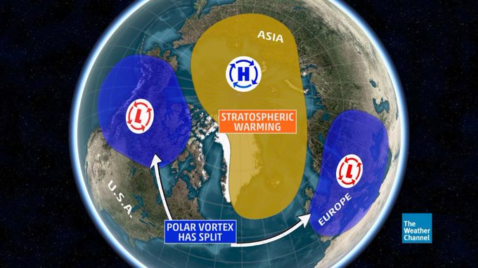
When this happens, the speed of the winds that make up the Polar Vortex slow down and sometimes reverse. This results in the collapse of the column of upper level air held aloft by the Vortex’s winds. When the air collapses, it compresses, causing the stratosphere to warm. This falling column of warm air then can end up acting like an atmospheric wedge — driving the Polar Vortex apart and causing it to split.
The split then tends to generate smaller funnels that capture polar air and pull it south. Beneath the funnels, it can be quite cold as Arctic air invades places like North America or the UK (as happened this week). But at the Pole, where the cold air should typically reside, it warms up enormously.


That’s how, under a regime of human-forced climate change, you can end up with periods where temperatures are warmer at the Pole than they are in Europe.


It’s worth noting that Polar Vortex collapse events did occur in the past. But not in such a way that generated the kinds of historically extreme Arctic temperatures we see today. The primary driver for the recently increased extremity of weather driven by Polar Vortex collapse events being human-caused climate change, Polar Amplification, and related influences on the Jet Stream.

Major flooding headed for US Northeast


Above:  Predicted rate of precipitation (in colors) and lines of constant pressure in millibars (black lines) for 18Z (1 pm EST) Friday, March 2, 2018, made by the 12Z Wednesday run of the GFS model. A powerful nor’easter with a central pressure of 975 mb was predicted to be off the coast of Southeast Massachusetts. The model predicted rain along the coast of New England, but snow over the high elevations of New York. Image credit: tropicaltidbits.com.
28 February, 2018
A low-pressure system centered over western Oklahoma on Wednesday morning is headed toward New England, and will dump heavy rains of 3 - 5” across portions of the Lower Mississippi Valley and Tennessee and Valley through Friday as the storm pulls near-record amounts of atmospheric moisture from the Gulf of Mexico. These rains will add to the ongoing serious flood event in the region.
By Thursday night, when the low will be passing near Cleveland and Pittsburgh, the system will undergo a complex interaction with a short-wave trough of low pressure to its north, resulting in the formation of a secondary area of low pressure--a nor’easter--off of the Northeast U.S. coast. This nor’easter will intensify dramatically on Friday, bringing a wide range of hazards to the Northeast U.S.—heavy rains of 2 – 3” along the coast, heavy snows in excess of one foot to the higher elevations of New England, strong winds with gusts up to 60 mph along the coasts of Rhode Island and Massachusetts, and a storm surge of 2 – 3’ (with 20 – 30-foot waves), capable of causing major coastal flooding and erosion to the coasts of Massachusetts, New Hampshire, and Maine.

A long-duration Nor’easter during the highest tides of the month

You know the coastal flooding situation may be serious when the normally dry and technical Scientific Forecast Discussion from Boston contains four exclamation marks in the marine impacts section, as it did on Wednesday morning. Unfortunately, a strong and slow-moving ridge of high pressure (a “blocking high”) over Greenland, which has brought an incredible flow of warm air northwards into the Arctic with above-freezing temperatures at the North Pole, will keep the weekend nor’easter from making much progress eastward. As a result, the Northeast U.S. coast will receive a punishing assault from a large storm surge and high waves that will last through three high tide cycles. Exacerbating the event will be the highest tides of the month—more than a foot above average--associated with the full moon.
In Boston, the worst flooding is expected to occur during the high tide cycles near 11 am Friday and 11 pm Friday, when waves of 25 – 30 feet are possible just offshore. The NWS in Boston was giving a low (< 30 %) of major coastal flooding, but predicted at least moderate coastal flooding with significant beach erosion. If the Wednesday morning guidance from the GFS model comes true, though, the coast from Boston to central Maine will experience a top-five highest storm tide on record during three tidal cycles—late morning on Friday, late evening on Friday, and again late morning on Saturday. This stretch of coast is already struggling with tens of millions of dollars in damage wrought by the storm surge of Winter Storm Grayson on January 4, 2018. That storm brought a top-five highest storm tide on record to the coast from Boston to Central Maine, including the highest water levels ever recorded at Boston, Massachusetts and Bar Harbor, Maine (see video below of storm surge flooding from that storm in Scituate, Massachusetts, located 30 miles southeast of Boston).

The "Beast from the East" strikes Britain and Europe


200 Million people in Danger - Stationary Nor'Easter & River Flooding & Atmospheric River

thornews


Europe freezes, Mediterranean snowed under

RNZ

Much of Europe has been blanketed in snow as cold weather spreads as far south as the Mediterranean coast.

A snowman is seen in front of the ancient Colosseum during a heavy snowfall on February 26, 2018 in Rome.A snowman is seen in front of the ancient Colosseum during a heavy snowfall on 26 February, 2018 in Rome. Photo: AFP

The cold spell, nicknamed "the Beast from the East" in the UK, is carrying freezing winds across the continent, and temperatures as low as -30°C.

At least seven people have been reported dead since Monday - five in Poland and two in Romania.

The International Committee of the Red Cross has appealed to the public to check on at-risk neighbours.

"Just knocking on someone's door to check they have everything they need can make a huge difference," the ICRC's Europe director, Simon Missiri, said.
"It could even be the difference between life and death."

Several trucks and cars, covered with snow, stand deserted after a pileup on February 27, 2018 near Sjobo, southern Sweden.Several trucks and cars, covered with snow, stand deserted after a pileup on February 27, 2018 near Sjobo, southern Sweden. Photo: AFP

Red Cross emergency teams have opened shelters and are providing hot food and blankets for thousands of people across the continent, it said.

Polish police said five people had died on Monday as the temperature dropped. Police have appealed to the public to assist the infirm - or the intoxicated - who have fallen in the snow.

Two more were reported to have died in Romania on Tuesday. One of the dead was an 83-year-old woman who was found collapsed in the snow, while another was a 65-year-old man, Reuters news agency reports.

Romanian police said they had closed dozens of roads, and that almost 100 trains had been cancelled.

On Tuesday, snow was seen on the excavation site of the ancient city of Pompeii, near Naples in southern Italy - where the average February temperature is 6°C to 14°C.

Naples saw its heaviest snowfall in decades, and the cold weather also hit Rome on Monday - its first snowfall in six years.

Germany's meteorological office, meanwhile, recorded a temperature of -30° at Zugspitze, the country's highest peak, and lows well below -10°C in most of the country.

AFP news agency reports a total death toll of at least 24 people in the past four days, adding that many of the deaths involved those sleeping rough in cities.
That includes three rough sleepers in France, three in the Czech Republic, and one in Italy, it said.

Emergency shelters have been opened by many authorities to cope with the needs of homeless citizens.

The cold weather is expected to continue until late in the week.

BBC weather said an approaching area of low pressure in the Atlantic would result in heavy snow - followed by rain - hitting France and northern Spain.
In northern Europe, biting cold winds are expected to continue, with more snow expected to reach the UK and Ireland by Thursday.
- BBC


 This picture was taken in Norwich last night, how is it that the shop manaquins are warmer than the people sleeping in this tent?

Red Alert:Highest level of danger as snow and ice cause UK travel chaos


Severe weather caused major travel disruption across the UK and Ireland on Wednesday as the “Beast from the East” tightened its grip.

Road closures, stranded vehicles and cancellations were widespread due to snow and ice.

Services on trains and planes were disrupted, with travellers urged to check with their transport provider before setting off on journeys.

Rail passengers were warned to avoid travelling to or from Scotland for all of Wednesday and into Thursday.

Meanwhile, hundreds of schools across Britain were closed for a second day.

Forecasters predicted the snow and freezing temperatures would not let up any time soon, prompting the Met Office to extend some of its weather warnings.

Rail companies warned delays may continue into Friday.

British Airways said the weather was likely to continue disrupting flights throughout the week.

From Thursday, forecasters predict that another weather system, Storm Emma, will bring blizzards, gales and sleet.

To follow the Independent's Live Updates GO HERE

From the BBC which hides as much as it reveals


Much of Europe has been blanketed in snow as cold weather spreads as far south as the Mediterranean coast.

The cold spell, nicknamed "the Beast from the East" in the UK, is carrying freezing winds across the continent, and temperatures as low as -30C (-22F).

At least 10 people have died since Monday, including many who were sleeping rough in cities.

Aid groups have opened shelters and are providing hot food and blankets for thousands of people.

The cold weather - called the "Siberian bear" by the Dutch and "snow cannon" by Swedes - brought rare snowfalls to parts of Spain and Italy and to the Mediterranean islands of Corsica and Capri.

Dozens of roads were closed and trains and flights cancelled across the continent. Hundreds of schools suspended classes and some businesses advised workers to stay at home.

Many regions were put on alert as the frigid temperatures were expected to continue until the end of the week.

Emergency shelters have been opened by many authorities to cope with the needs of homeless citizens. In Belgium, police were allowed to detain people overnight if they refused to go to shelters.

The International Federation of the Red Cross and Red Crescent Societies appealed to the public to check on at-risk neighbours.

"Just knocking on someone's door to check they have everything they need can make a huge difference," its Europe director, Simon Missiri, said. "It could even be the difference between life and death."

At least five people died in Poland while four deaths were reported in France, including a nonagenarian who was found outside the gate to her retirement home, AFP news agency reports.

Three deaths were confirmed in Lithuania and two in Romania, including an 83-year-old woman found collapsed in the snow.

A 47-year-old homeless man died in the Italian city of Milan.

The toll across Europe could be as high as 24, AFP adds.

Rome saw its first snowfall in six years while Naples had its heaviest snowfall in decades. On Tuesday, snow was seen on the excavation site of the ancient city of Pompeii, near Naples in southern Italy - where the average February temperature is 6-14C.

Germany's meteorological office, meanwhile, recorded a temperature of -30C at Zugspitze, the country's highest peak, and lows well below -10C in most of the country.

In the French capital Paris, where temperatures dipped to -6C, commuters shared pictures of stalactites on the walls of at least two metro stations.

Authorities have also warned of treacherous conditions on roads and in the Spanish region of Catalonia the public were advised to avoid driving if possible.

BBC Weather says biting cold winds are expected to continue in northern Europe while more snow should reach the UK and Ireland by Thursday.

The UK is experiencing what is predicted to be the coldest week of the winter season in five years with temperatures reaching almost -12C in some areas


This is the "Beast from the East" - actually from the North Pole - which is causing an emergency, especially in Scotland where whole towns are isolated.