Showing posts with label wildfire. Show all posts

Monday, 28 September 2020

BREAKING: Wildfire approaching Santa Rosa, Sonoma Country

 Shady Fire Approaching Santa Rosa - LIVE BREAKING NEWS COVERAGE

The Shady Fire in California is approaching Santa Rosa in Sonoma County. Get the latest on the wildfire situation in and around Santa Rosa in our LIVE SHADY FIRE COVERAGE


High winds, triple-digit temperatures and an elevated fire risk will greet Bay Area residents by the end of the weekend and into the start of the week, with Monday expected to see the peak of a current heat wave before some modest relief arrives primarily to coastal areas, according to weather forecasters.

Correspondingly, air-quality officials have issued another Spare the Air alert for Sunday — saying the air is unsafe for people with respiratory sensitivities — and low humidity has prompted the National Weather Service to extend a red-flag wind warning for the region through Monday evening, past its previous Monday morning endpoint.

“We’re going to see fairly consistent offshore winds across the board, and strong winds in the upper altitudes,” NWS meteorologist Brayden Murdock said.

A heat advisory has also been issued for the entire Bay Area, with the weather service urging people to seek indoor and air-conditioning relief wherever possible and to avoid being outdoors in the midday. Bay Area municipalities are once again opening up cooling centers through at least Monday to offer relief to residents with limited access to air-conditioning or shelter from the outdoor heat.

That compounds an advisory PG&E issued for planned power shutoffs in 16 Northern California counties, though the Bay Area impact would be modest, with about 200 customers in Napa County and only two Sonoma County customers slated for potential outages starting 4 p.m. Sunday.

Most of the 89,000 affected customers will be east and north of the Sacramento area, led by about 35,000 customers in El Dorado County being put on notice for outages, also set to take effect Sunday afternoon.

The red-flag warnings are based on forecasted wind speeds approaching 50 mph in the North Bay mountains and East Bay hills, and adjacent areas like the Livermore Valley, Murdock said. Along the coast, that increases the threat of rip currents.

As far as temperatures go, San Francisco could flirt with 90 degrees Sunday, joined by cities that dot the interior shorelines on both sides of the bay. The areas that typically see the region’s hottest readings — Livermore, Gilroy, Santa Rosa, and parts of Marin County — are expected to break 100 degrees.

That is forecasted to continue into Monday, when San Francisco could see temperatures creeping into the upper 90s. San Jose is predicted to see a high of 96 degrees; 102 in Oakland; 103 in Walnut Creek; and 95 in Fremont, to round out a sampling.

All of the Monday temperatures are part of an expected warmup for this time of year, but the range and ceiling of the heat is “pretty well above average,” Murdock said.

As for relief? Some will see temperatures taper off Tuesday, but the coastal areas will notice that the most, with most other inland cities seeing a dropoff of just a few degrees.

https://www.timesheraldonline.com/2020/09/27/bay-area-heat-scorching-temps-red-flag-warning-extended-another-spare-the-air-alert/


Friday, 11 October 2019

Saddleridge Fire IN Sylmar, CA


I am going to have to return to this. Suffice it to say, there is a lot that does not make sense

Saddleridge Fire Threatening Homes in Sylmar, CA - LIVE BREAKING NEWS COVERAGE


The Saddleridge Fire, a new wildfire in Sylmar, California (a neighborhood of Los Angeles), is threatening to engulf homes and power lines. Get the latest in our LIVE COVERAGE.

The Saddleridge fire began tonight and grew explosively in the last hour thanks to high winds. It roared across the 210 freeway in Sylmar, and is now threatening power lines and homes. Some structures are already burning

The OFFICIAL story

Wednesday, 14 November 2018

On Los Angeles'secret nuclear meltdown in 1959

Check back tomorrow for the Nuclear Hotseat report on this.
 

L.A.'s Secret Meltdown; Simi Valley, CA(1959)Largest Nuclear Incident in U.S. history.


Documentary film covering the top secret 1959 Sodium Reactor meltdown in Los Angeles, California. The incident, kept secret for decades, resulted in the deaths of an estimated 300 to 1,800 people and is the suspected source of elevated cancer rates in adjacent suburban communities. The amount of contaminants released have been estimated at over 400 times that of the highly publicized Three Mile Island incident. This film features accounts from former Atomics International employees detailing the incident that sent highly radioactive gases over parts of Los Angeles for two weeks. Employees also recall illegal acts of mass pollution such as open burn pits that sent radioactive waste into the open air for decades. These experiments took place at the Santa Susana Field Laboratory, in the hills between Los Angeles' San Fernando Valley and Simi Valley.

The film gathers comprehensive incident footage and testimonial interviews with local survivors, physicians, scientists, researchers and reporters regarding the 1959 meltdown and the grassroots movements to clean the site in order to save generations from exposure to it's migrating contaminants.


Peter Ptak, via Facebook


"Physicians for Social Responsibility Los Angeles is refuting the Department of Toxic Substances Control’s claim that the path of the Woolsey Fire isn’t likely to have resulted in particularly toxic smoke or ash.


Dr. Robert Dodge, the organizations president wrote, “We know what substances are on the site and how hazardous they are. We’re talking about incredibly dangerous radionuclides and toxic chemicals such a trichloroethylene, perchlorate, dioxins and heavy metals. These toxic materials are in SSFL’s soil and vegetation, and when it burns and becomes airborne in smoke and ash, there is real possibility of heightened exposure for area residents.”

Monday, 29 October 2018

Massive wildfire in Western Australia seen from Space


Bushfire in Australia burns over 2 million acres, becoming a “gigafire”
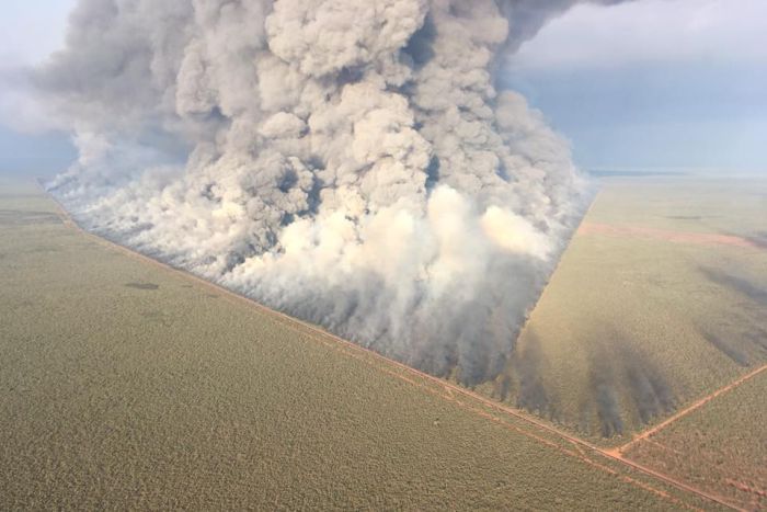
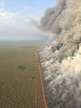
"Bushfire Broome, Western AustraliaBushfire south of Broome, Western Australia. Photo: Department of Fire and Emergency Services.
26 October, 2018


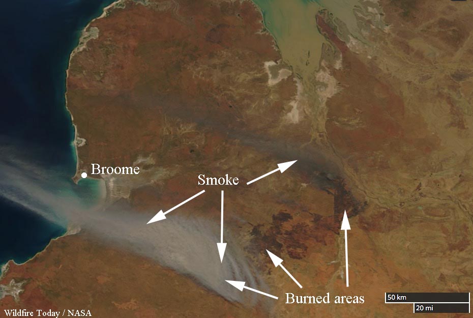
A bushfire that started October 11 in Western Australia 120km southeast of Broome burned 880,000 hectares, or 2,174,527 acres. Dry winds from variable directions and high temperatures made it very difficult to suppress. The remote location and a lack of water restricted the tactics to fighting fire with fire, constructing firelines with heavy equipment, and using aircraft.

When the wind direction changed last week, firefighters had to shut down the Great Northern Highway, National Route 1.

bushfire Western AustraliaSatellite photo of bushfire in Western Australia, October 15, 2018. NASA.
When we coined the term “megafire” for wildfires that exceed 100,000 acres, it was in the back of our mind that if a fire reached 1 million acres it would be called a “gigafire”.

In spite of the enormous size of the blaze in Western Australia there were no fatalities or damage to major structures.

The Department of Fire and Emergency Services (DFES) urged residents at Thangoo Homestead, Barn Hill Station, and Eco Beach last Tuesday to evacuate or actively defend their property.

DFES West Kimberley area officer Ben Muller said there were approximately 100 personnel fighting the fire.

The city of Broome was given the all clear Thursday morning.
Below is an excerpt from an article at TheWest.com:
Thangoo Station manager Rex McCormack said about half of the pastoral station was burnt but people and livestock were unscathed and water tanks and other important assets were undamaged.
It is one of the biggest fires I remember from the last 10 years, but we felt safe in staying and defending the property,” he said.
I didn’t feel scared in staying, I would have been more worried about that damage that could have occurred if I wasn’t there and it was more about being a resource to DFES.
We were out back burning the property until about 1am last Wednesday, then up again at 6am.


Bushfire Broome, Western Australia 
Bushfire south of Broome, Western Australia. Photo: Department of Fire and Emergency Services.


Massive Australian Bush Fires Visible By Satellite

Robert Fanney

Monday, 5 February 2018

NZ: Fire on the Chatham Islands

Wind helps fire crews subduing Chatham blaze
Firefighters on Chatham Island are battling to keep a 3000ha fire away from a conservation reserve.
Images taken from a Royal New Zealand C-130 of a bush fire on the Chatham Islands. The images were taken in order to inform New Zealand Fire And Emergency of what will be required to subdue the blaze.Images taken from a Royal New Zealand C-130 of a bush fire on the Chatham Islands. The images were taken in order to inform New Zealand Fire And Emergency of what will be required to fight the blaze. Photo: Supplied / New Zealand Defence Force

5 February, 2018

Fire crews have been flown to the Chathams from Wellington to battle the fire, which has been burning since Thursday.
Rural fire officer Craig Cottrill told Morning Report the fire was not yet contained.
"I would say the best way to describe it is almost contained," he said.
He said the wind conditions would be helpful today, with the northerly blowing the fire back on itself.
"The fire started sort of five or six kilometres off the road south of the Waitangi-Owenga road, and it's burnt through to the coast.
"Later on tomorrow the wind's going to shift off to the west so efforts today with the helicopter will be dampening down the front on the east side to keep it out of the Department of Conservation (DOC) scenic reserve we've got there."
Yesterday an @NZAirForce C-130 Hercules flew over the Chathams bushfire to help@FireEmergencyNZ map the scale of the blaze. This shows some of what they've been dealing with.
"Having the two helicopters and the two specialist rural fire crews out there has really made a difference."
It was well away from people's homes, but less than 1km from a DOC reserve, he said.
"It's just significant biodiversity values in there. The ecology and the vegetation in there."
He said Moriori tree carvings were much further north.

Mr Cottrill said it could take as long as two weeks to completely douse the fire.

Saturday, 9 September 2017

(Almost) unreported: Wildfire burning in former Nevada nuclear site

At least according the Google this is the only place this was reported. I heard about it on Nuclear Hotseat.

The Latest: Wildfire burning in former Nevada nuclear site


31 August, 2017


RENO, Nev. –  The Latest on wildfires burning across the western United States (all times local):
1:15 p.m.
An official says firefighters are battling a lightning-sparked wildfire in a remote part of the vast former national nuclear proving ground north of Las Vegas.
Nevada National Security Site spokeswoman Tracy Bower said Thursday that the fire covers almost 4 square miles (10 square kilometers) in the western part of what used to be the Nevada Test Site.
More than 1,000 nuclear detonations occurred at the 1,360-square-mile (3522-square-kilometer) secure federal reservation from 1951 to 1992. It now hosts non-nuclear experiments and safety training.
Bower didn't have immediate information about the exact location of the fire or what tests may have taken place in the burn area in the past.
She says the fire started Monday and isn't considered a threat to people or buildings.
It's being fought by security site fire crews, with help from a helicopter able to detect any aerial release of radiation.
____
11:30 a.m.
Fire crews battling a wildfire that has destroyed 10 homes near the Northern California town of Oroville were able to slow its growth overnight.
The California Department of Forestry and Fire Protection said Thursday that the blaze about 70 miles (112 kilometers) north of Sacramento had consumed nearly 5 square miles (13 square kilometers) and was partially contained. It's still threatening 500 homes.
It says fire crews from across California are joining more than 1,000 firefighters battling the fire that started Tuesday.
It's one of many wildfires burning across the U.S. West, including blazes in and around California's Yosemite National Park that have closed a popular road into the park, shuttered the iconic Wawona Hotel and evacuated nearby towns.
About 58 homes near the park were destroyed earlier this summer.
___
11 a.m.
Firefighters battling a wildfire near the Burning Man festival say they're trying to keep the main highway open to the counterculture celebration in the Nevada desert.
Nevada Highway Patrol Trooper Dan Gordon says State Route 447 connecting Interstate 80 to the festival was closed for several hours overnight but reopened Thursday morning.
Gordon says traffic is moving in both directions but it's "very slow going."
Interagency fire spokesman John Gaffney says the biggest priority is protecting about a half dozen ranches threatened by the fire that has burned about 45 square miles (116 square kilometers).
The blaze is about 40 miles (64 kilometers) south of Burning Man.
He says aircraft are attacking the flames that are chewing through sagebrush and cheatgrass in temperatures expected to reach triple digits.
___
11:45 p.m.
Ten homes have been destroyed and 500 more are threatened near the Northern California town of Oroville.
The area has already been hard-hit by fire and a massive evacuation earlier this year caused by damage to sections of the nation's tallest dam.
Authorities on Wednesday arrested a man suspected of starting an illegal campfire believed to have ignited the blaze that has also damaged five homes.
It's one of many wildfires burning across the U.S. West, including blazes in and around California's Yosemite National Park that have closed a popular road into the park, shuttered the iconic Wawona Hotel and evacuated nearby towns.
About 58 homes near the park were destroyed earlier this summer.

Tuesday, 28 June 2016

Death toll in Eskine Fire in California

Possible Rise in Death Toll Caused by California Wildfire, Remains Found

A raging wildfire in Central California has killed two people and is feared to kill more, authorities said.


27 June, 2016


The Erskine Fire, which wreaked havoc in the Lake Isabella area of Kern County north of Los Angeles, California last Thursday, has already threatened over 1,500 lives and burned down about 200 homes.

The remains of two elderly people - a man and a woman - were found on Friday, the Kern County Fire Department said.

Authorities said that the bodies were discovered outside a burned-down house, and it seemed that the pair were trying to escape the flames when they were overcome.

Another set of remains has been found on Saturday, but authorities have not yet confirmed whether they were human.

"We've located what we believe are human remains," Ray Pruitt, spokesman for the Kern County Sheriff's Office, told Los Angeles Times.

"We are treating it like a crime scene. ... It appears to be one set of human remains, pretty badly burned."

Officials told NBC News on Sunday that death toll may continue to rise. Cadaver dogs were also brought in to search for remains.

Officials announced that the fire was 40 percent contained on Sunday night.
The Erskine Fire had grown from 37,000 acres to 43,360 acres during the day, racing through rural communities and wiping out entire blocks. Authorities said on Sunday that about 2,500 homes remain under threat.

Governor Jerry Brown declared a state of emergency and authorized the use of funds and resources to fight the fire, ABC News reported.

The cause of the fire is still a subject of criminal investigation. But Kent County Fire Engineer Anthony Romero told NBC that the scorching weather could make it difficult for fire fighters to contain the fire.

"That's something we have to keep an eye on," Romero said. "It could spark another disaster."

The hot and dry weather have contributed to massive wildfires in Southern California in the past week, including twin fires in the San Gabriel area that burned 5,267 acres and another in San Diego County, which affected 7,609 acres. But according to fire authorities, most were almost 60 percent contained.


Wednesday, 18 May 2016

Fort McMurray fires: the Beast roars back into the tar-sands

We are living now in the Age of Consequences on a day where nothing else really matters, except for the rapid growing climate crisis (that's the wrong noun) and the consequences.


"Such huge extents of extreme fire hazard over northern and far-northern regions that typically experience much, much cooler weather is a feature that is absolutely consistent with effects resulting from human-forced warming. A warming that continues to be made worse by the extraction of carbon-based fuels like those unearthed at the tar sands facilities now endangered by the very fires of climate change they helped to ignite."


First just the facts presented in a way that matters.

The Beast Growls — Warming-Induced Wildfire Again Doubles in Size, Burns Tar Sands Workers’ Camp


18 May, 2016
On Monday, strong southerly winds and freakishly hot temperatures near 80 degrees (F) combined to fan the still-raging Fort McMurray Fire in Alberta, Canada. The monstrous, climate change enhanced, blaze swelled. And by the end of the day it had expanded to cover more than 354,000 hectares, 1,360 square miles, or an area larger than the state of Rhode Island.
In a little more than a week, a fire that emergency response personnel are calling ‘The Beast’ had once again doubled in size.
The Beast Growls
(The Fort McMurray Fire again exploded on Monday — invading tar sands facilities even as the eastern sections of the fire came to within 7 kilometers of the Saskatchewan border. Image source: LANCE MODIS.)

As the fire expanded, it swept north and east. Casting off choking, dense smoke, the fire spiked air quality ratings to 38 (a 10 is considered dangerous), forcing emergency response personnel, workers, and those few people now inhabiting the blackened town of Fort McMurray to wear particulate filtration masks. The bad air quality caused some officials to speculate that the return of more than 80,000 residents to the town could be delayed. The evacuees had been forced from their homes by the fires during early May — a wave of climate change refugees that have now faced a three week period of dislocation. But any thought of residents returning was swiftly overwhelmed by the rapidly-expanding fire itself.

8,000 More Evacuations, Oil Worker Camp Burned

As the town of Fort McMurray choked in the smoke of resurgent fires, walls of flame moving north and east again threatened tar sands facilities. Firefighters scrambled to widen fire breaks as fires moving as fast as 40 kilometers per hour leapt defensive lines and entered some of the industrial sections.
Ironically-named Travis Fairweather, a wildfire information officer, described the completely untenable situation:
Yesterday the fire was showing extreme behaviour and lots of smoke in the air. We had to pull the firefighters off the line because it was so dangerous out there.”
The entire industrial zone fell swiftly under threat and by late Monday more than 8,000 tar sands workers from a total of 19 camps had been ordered to evacuate. By Tuesday morning, the Blacksand Lodge — a temporary residence for oil workers manning tar sands facilities located 35 kilometers to the north of Fort McMurrary — had succumbed to the flames. A large facility, the Blacksand camp provided 665 residential units for workers. In total, it’s estimated that about 6,000 workers remain in tar sands facilities and emergency responders are coordinating to organize an air evacuation if necessary.

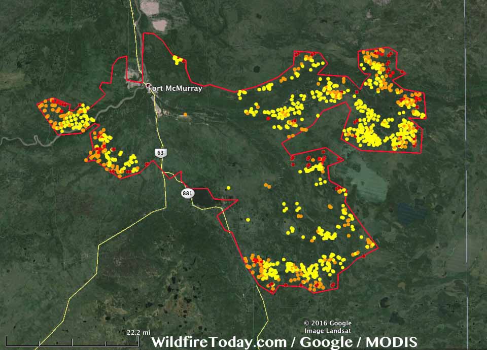
Fort McMurray fire extent May 16
(Fort McMurray Fire extent with hotspots as of early Monday on May 16. The region affected by the fire as of this time was truly vast — stretching nearly 50 miles long and 30 miles wide. Through late Wednesday, the massive blaze is likely to again claim more ground. Image source: Wildfire Today.)

Fire Situation to Remain Extreme on Tuesday and Wednesday

Southerly winds and far above average air temperatures are again expected to worsen fire conditions on Tuesday and Wednesday. Highs are predicted to hit near 80 in Fort McMurray on both days and dry conditions are expected to dominate. So continued rapid growth of the McMurray Fire over this period is likely. With fires now on three sides of the industrial zone and within sections of the tar sands facilites, we can expect a continued threat to the oil production zone over at least the next 48 hours.
Long range forecasts indicate that warmer than normal conditions are likely to continue over the next week. However, rainfall predicted on Thursday and Saturday could again slow the fire’s growth — giving firefighters another shot at containing this massive blaze. It’s worth noting, though, that the fire is now so large and intense that it will likely take weeks to months to extinguish.
Extreme Fires in the Context of Human-Caused Climate Change

Overall, more than 530,000 hectares have now burned throughout Canada. This total is more than 24 times the amount of land consumed in fires by this time last year. During the 20th Century, large May burn extents of the kind Canada is experiencing during 2016 were unheard of. For much of Canada — May tended to be a cool month featuring temperatures in the 40s, 50s and 60s (F). Not the 70s and 80s (F) that have tended to crop up so frequently this year. Fires tended to be sparse and small — if they ignited at all. But the heat, a growing number of dead trees, and a thawing zone of carbon-rich and flammable permafrost have all added to the fire danger. Evidence that a very rapid pace of warming and related damage to Canada’s forests is having an extraordinary and dangerous impact.


Over the coming seven days, abnormal 60-70 degree (F) temperatures are expected to expand throughout even the far northwestern regions of Canada — reaching all the way to where the Arctic Ocean meets the Mackenzie Delta and spiking fire hazards within that thawing permafrost zone. Such huge extents of extreme fire hazard over northern and far-northern regions that typically experience much, much cooler weather is a feature that is absolutely consistent with effects resulting from human-forced warming. A warming that continues to be made worse by the extraction of carbon-based fuels like those unearthed at the tar sands facilities now endangered by the very fires of climate change they helped to ignite.

Links:
Hat tip to DT Lange
Hat tip to Colorado Bob
Hat tip to Greg
Hat tip to Redsky