Showing posts with label nuclear accident. Show all posts

Monday, 11 February 2019

Focus on Novaya Zemlya

Novaya Zemlya, in the Barents Sea has come into focus though this story.


Polar bears are on the Red List and have been protected in the Russian Arctic since 1956.

The Arctic is in transition, heading towards a warmer future with less ice, with maybe far-reaching implications for the king of the Arctic - the polar bear.

In recent years, polar bears have more frequently approached coastal towns in northern Russia, both on the mainland and on the archipelagoes.

Due to shrinking sea ice, the bears are often stranded on shore. Either because the sea ice retreat from shore much earlier in summer than before, or like on Novaya Zemlya, the sea simply does not freeze any more during winter.


Ice-map provided for the area by the Norwegian Meteorological Institute's Ice Service from Friday shows how the Kara Sea off the east coast of Novaya Zemlya is packed with very close drift ice, while there are mostly very open drift ice and open water along the west coast where Belushaya Guba is located.

***

It is also an area that Margo have been watching carefully since the 2018 melt season because of the large quantities of methane being released in the region.

A few months ago, Margo did a superb job in trying to answer the question as to why the Arctic is warming at twice the rate of the rest of the world.

She came to the conclusion that there is so much more than what we are being told behind this.

Greenhouse gases - yews, for sure, but there may other factors coming into play.

This is Margo's conclusion. It's not exactly my language (although decreasingly so)


Before rejecting it have a look at the evidence first.


Novaya Zemlya: The Smoking Gun for Rapid Arctic Warming?

Why the Arctic is warming twice as fast as the rest of the planet. It all centers around the tiny Russian island, Novaya Zemlya.


Margo has done a first-rate job of collecting information on Russia's massive nuclear testing program and providing evidence that this radioactivity and the heat associated with it has to have had a role in the warming of the Arctic and why Novaya Zemlya seems to be a centre for the massive release of methane in the region.

She does a first-rate job of demonstrating that there is more to the puzzle than just the release of methane from melting permafrost.

Take the time out to listen to the video below.

For ease I have put together all the material Margo has presented as well as material I have uncovered.


Firstly, a brief introduction to the area and its geography.


And the topography of the southern island. Plenty of material here for the melting of permafrost!


Margo goes through Wikipedia and other sources to look at the Soviet nuclear testing program and uncovers the huge number of tests - above ground, undergrounds and failed tests.

It's mind- blowing!


Here is footage of the 1961 explosion of Tsar Bomba, which had a reported yield of 50 megatons, the single most physically powerful device ever deployed on Earth.


It has been estimated that detonating the original 100 Mt design would have released fallout amounting to about 26% of all fallout emitted since the invention of nuclear weapons.


Here is a report on the test:


Date: 30 October 1961
Location: Novaya Zemlya, Russia, USSR
Type of event: burn injury from atmospheric nuclear test
Description:
At 8:33 UT on 30 October 1961 the USSR conducted the world's largest nuclear test. The device was designated RDS-220 and nicknamed "Vanya" or "Tsar Bomba" (King of Bombs); it was a three-stage thermonuclear device with a mass of 24.8 metric tons. The full design yield is reported as 100 megatons or 150 megatons, but in the test device the uranium sleeve on the tertiary stage was replaced with lead to reduce the yield to about 50 megatons. The RDS-220 was air-dropped from a Tupolev-95V bomber, a Tu-95 version specially modified to carry the device, from an altitude of 10,500 meters. It descended by parachute, allowing the bomber and chase planes to reach a distance of 45 km before detonation at an altitude of 3,500 meters with a yield of 58 megatons. Although the delivery bomber and chase planes had been painted with reflective paint to avoid thermal damage, cables were ignited on one Tupolev-16 chase plane, causing burns to one crew member.
Consequences: 1 injury.

***

And a report on a 1969 underground nuclear test.


At 07:00 UT on 14 October an underground nuclear test was conducted at the Matochkin Shar region in Novaya Zemlya. Three devices were detonated in two tunnels with a total yield of 540 kt: one device yielding between 20 and 150 kt along with one device yielding between 150 and 370 kt in tunnel A-7, at a depth of 500 meters; and one device yielding between 150 and 370 kt in tunnel A-9 at a depth of 520 meters. About one hour after the test a gas plume burst from the surface near tunnel A-9. Factors in the early venting included reaction with carbon dioxide in the surrounding rocks, thermal weakening of the cement plug around the nuclear device, and gas escape facilitated along a fault to the side of the mountain. Several hundred test personnel were in the vicinity and were not evacuated until 40 to 60 minutes later; the response to the accident was confused, compounded by the early departure of those in authority. On 24 October those more seriously exposed were transported to Moscow for examination and treatment. Over 80 people received doses of 40 to 80 rad.
Consequences: Unknown number of injuries.

http://www.johnstonsarchive.net/nuclear/radevents/1969USSR1.html

***


This is the chart that Margo uses to conclude that warming in the Arctic started in 1960 which corresponds to the detonation of Tsar Bomba and subsequent tests.
.
Here is a collection of material that directly, or indirectly corroborates Margo's thesis


A science expedition to the area has discovered “big concentrations of radioactivity” in the ice – and concludes that the glaciers are melting into the sea at record speed.


It is December and European Arctic waters are free of ice way north of Svalbard and Novaya Zemlya.


The photo of a nuclear bomb test going terribly wrong in August 1987 is revealed by a Russian blogger.


We don't hear very much from Russia and climate change - so here are a couple of examples


Russian Ministry Warns of Coming Environmental Apocalypse Fueled by Climate Change

On thin ice, North Pole camp folds after only 12 days


Sources


Thursday, 15 November 2018

Dangerous" Radioactive Particles Into The Atmosphere from SoCal fire


WOOLSEY FIRE AND THE SANTA SUSANA FIELD LABORATORY

14 November, 2018
AERIAL PHOTO FROM CBSLA SHOWING THE START OF THE FIRE AT SSFL. HTTPS://TWITTER.COM/STU_MUNDEL/STATUS/1060692904107110400

We’ve received quite a few inquiries over the past several days regarding the potential consequences of the Woolsey Fire in Southern California, which has burned through part of the Santa Susana Field Laboratory (SSFL) site in Ventura County immediately south of Simi Valley. The SSFL site, which closed in 1996, housed ten nuclear reactors as well as rocket engine test facilities, and is highly contaminated with radioactive and toxic wastes remaining from decades of poor disposal practices and numerous accidents. The public is understandably concerned about the possibility that contaminants have been spread by the fire, which reached the site on Fri. Nov. 8th, but was reportedly no longer burning within it the following day.

SAFECAST RADIATION MAP OF THE REGION AFFECTED BY THE WOOLSEY FIRE, WITH CAL FIRE DATA OVERLAY. SSFL LOCATION INDICATED BY A RED DOT.

Safecast had no survey data from the immediate SSFL area prior to the fire, but we had a fair amount of data from nearby communities which showed it to be at normal background levels. Our realtime radiation and particulate sensors in the Southern California region, the closet of which is 30km (about 18 miles) away from SSFL, have shown no measurable increases in radiation. Safecast volunteers are on the way to the site, however, so hopefully we will have new data to share soon. Though CalFire indicates that the fire danger in the SSFL area has passed, many roads are still closed, making access difficult. 

SATELLITE IMAGERY FROM JPL/ARIA. AREAS AFFECTED BY THE WOOLSEY FIRE ARE SHOWN IN COLOR. SSFL IS LOCATED WITHIN THE AREA INDICATED BY THE GREEN CIRCLE (ANNOTATED ADDED BY SAFECAST).

Official agencies, including the California Department of Toxic Substances Control (DTSC ) and the LA County Department of Public Health have issued statements saying that they have surveyed the site and detected no radiation above normal background levels. As of this writing, neither agency has provided actual measurement data or details about their methodology. One potential health concern would be from inhalation of radioactive material lofted by the fire and carried by the smoke plumes. Inhalation of smoke and particulate matter itself certainly presents a health risk, and people living in the region have been advised to protect themselves against that. As has been demonstrated at Chernobyl, wildfires in radioactively contaminated areas can resuspend radioactive material and carry it significant distances. The Chernobyl research cited above, which analysed the effects of fires of similar magnitude to Woolsey in a more highly contaminated region, suggested that radiation doses to the most affected people would be higher than background but still within the same range. These researchers were able to make these estimates because they were able to carefully measure the radiation that was released by the fires.

AERIAL PHOTO OF SSFL SITE, 1985, SHOWING SITES OF ACCIDENTS AND OTHER INCIDENTS (CREDITS: PHOTO: DOE; ANNOTATIONS: SSFL WORK GROUP)
 
Radioactivity from ground contamination is relatively easy to measure, and we should be able to answer some questions about this soon. In addition, we will continue to look for available data that might show changes in airborne radiation that may have been caused by this fire. This would have to come from radiation monitors that were already in place nearby beforehand. This is why Safecast continues to stress the importance of having sensors in place before an incident like this occurs. Without adequate data, important questions cannot be answered, and there is no substitute for being prepared.
 
More information:

6, Article number: 26062 (2016)


SoCal Fire May Have Ejected "Incredibly Dangerous" Radioactive Particles Into The Atmosphere

14 November, 2018

The 95,000 acre Woolsey fire which has coated Southern California with an apocalyptic orange glow may have released a toxic stew of radioactive particles and toxic chemicals into the air, after scorching the land on closed-down government weapons testing facility in Simi Hills known to be heavily contaminated from decades of experiments.

Commencing operation in 1947 for Rockwell's Rocketdyne Division, a government contractor for the Atomic Energy Commission (AEC), the Santa Susana Field Lab (SSFL) has a checkered safety record, to put it lightly. In addition to several nuclear accidents - including the worst nuclear meltdown in US history, toxic materials have accumulated on-site from years of dumping, just miles from thousands of residents. 


It was the site of several nuclear accidents, including the worst nuclear meltdown in US history when, in 1959, facility operators intentionally vented nuclear material from the site’s “Sodium Reactor Experiment” to prevent it from overheating and exploding. By the time the leaks were closed, the site had released 459 times more radiation than was leaked during the better-known 1979 meltdown at Three Mile Island.
The lab property, now owned by airplane manufacturer Boeing, stretches for 2,800 acres in the Simi Hills, and remains contaminated with toxic materials. Thousands of people live within two miles of the site, and roughly half a million live within 10 miles, according to an investigation by NBC 4 Los Angeles. -Quartz  

California officials with the state's Department of Toxic Substances Control said that as of Friday, November 9, an area of the SSFL site which was scorched by the Woolsey fire posed no danger, stating "Our scientists and toxicologists have reviewed information about the fire’s location and do not believe the fire has caused any releases of hazardous materials that would pose a risk to people exposed to the smoke." 

A group of concerned physicians begs to differ. 

According to Robert Dodge - a physician and president of Physicians for Social Responsibility Los Angeles, highly toxic materials embedded in SSFL's soil and vegetation may have been spewed into the air by the Woolsey fire. 
"We know what substances are on the site and how hazardous they are. We’re talking about incredibly dangerous radionuclides and toxic chemicals such a trichloroethylene, perchlorate, dioxins and heavy metals," said Dodge, adding: 

"These toxic materials are in SSFL’s soil and vegetation, and when it burns and becomes airborne in smoke and ash, there is real possibility of heightened exposure for area residents."
Weighing in with satellite imagery tells a similarly two-sided story. These images show that the fires did spread to the compound, but they didn’t take down structures. With near-infrared imagery, dense vegetation appears red while burn scars from the Woolsey fire contrast as dark brown.


Dodge's group has also criticized the California Department of Toxic Substances Control - pointing out that the state-run agency is currently under a state-mandated independent review to investigate its handling of toxic cleanups. 

According to a Draft environmental statement from the Energy department, Santa Susana Field Laboratory and its adjoining Northern Buffer Zone has never been fully cleaned up


A 1998 article of Los Angeles Magazine details horrific cancers and other conditions which have afflicted those living near, and working at the site. 
"Children growing up near the site swam and fished in streams and played in the dry wash. And one day, Garner rode his red J.C. Higgins bike he got for Christmas through effluent flowing from the lab. 
Garner, now 44, lives in Simi Valley. An ironworker, he's done contract jobs at the lab over the years. In October 1996, he was diagnosed with lymphoma. His wife Leslie had her uterus removed because of cervical cancers. His father - like Garner an ironworker employed occasionally at the lab - has skin cancer and heart problems and is near death. His sister Vickie, 46, has heart and thyroid problems. On one side of a single block of Ramara Avenue in Woodland Hills, five miles from the plant, cancer has been diagnosed in 9 out of 10 houses." -Los Angeles Magazine

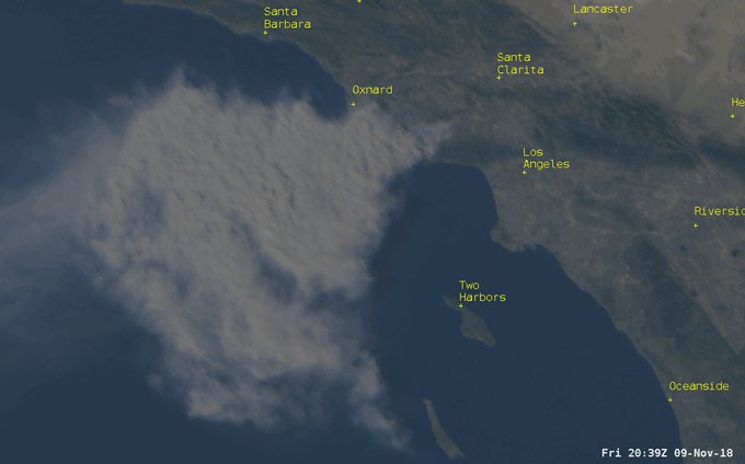
Meanwhile, here's where the potentially toxic plume of smoke traveled as of November 9:


Embedded video

Here is a look at the Woolsey Fire in California as seen from the GOES-16 Weather Satellite this afternoon.
218 people are talking about this