
 Posts
Posts


Monster El Nino Turns Typhoon Eyes Toward Arctic
20
August, 2015
What
does a Monster El Nino look like? In two words — climate change.
And by the end of August climate change’s Monster El Nino may have
spawned two strong tropical cyclones and hurled their powerful
remnant systems into the Arctic.
The
2015 Monster
The
Equatorial Pacific is cracking wide open. Heat, at near new records
for August, is oozing out. In
the Nino 3.4 zone last week, the heat bleed hit a new intensity of +
2 degrees Celsius above average.
That puts our current El Nino easily in the running for one of the
top three strongest. And the warming there is expected to continue
through at least October — possibly setting up conditions in which
the 2014-2016 El Nino is the most intense and perhaps longest-running
such event ever seen.
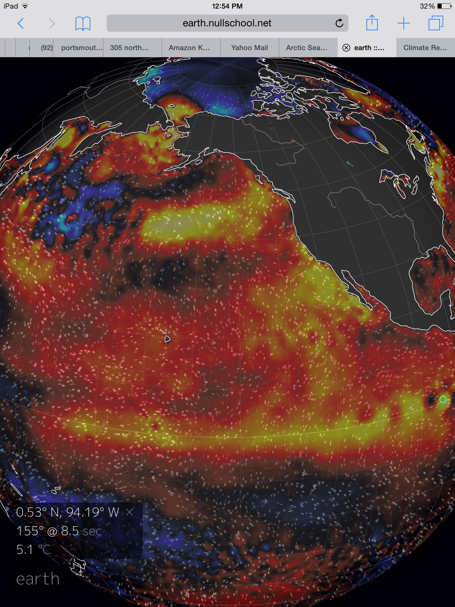
(Our
Monster El Nino and three hot blobs — one off California, one off
the Pacific Northwest, and one in the Bering and Chukchi — just
keep getting hotter and hotter. The extremity of heat covering this
section of the Pacific Ocean is simply extraordinary. And the fact
that it keeps building may have some serious impacts on Pacific,
Arctic, and North American weather patterns. Image source: Earth
Nullschool.)
Unlike
typical El Ninos, the high heat anomalies are not isolated to a band
along the Equator. They extend upward across a vast pool that
encompasses practically all of the Northeastern and North-Central
Pacific. All of the Bering Sea and a chunk of the Arctic Ocean as
well. It’s as if the typical El Nino heat has developed a great
chimney that runs over thousands of miles from Equator to Arctic. One
that encompasses millions of square miles of much warmer than normal
ocean surface. An entire zone that, for the ocean, is a blistering
1-5 degrees Celsius hotter than ‘normal.’
The
Warming World’s Intense El Ninos’ Dance With Polar Amplification
Scientists
have long warned us about this. Warned us that increasing global
temperatures through ongoing fossil fuel burning could greatly
amplify the intensity and the frequency of strong El Nino events. A
recent paper published in Nature has continued this line of research
finding that, under human-forced global warming, the
frequency of strong El Ninos is doubled.
And, right on queue, the 2014-2016 El Nino is shaping up to be one of
the nastiest, if not the nastiest such event we’ve yet experienced.
But
it’s not just a question of the intensity of heat boiling out of
the Equatorial Pacific. It’s also a question of how a strong El
Nino behaves in a world that has been forced to warm by 1 degree
Celsius. According to Dr. Jennifer Francis, a significant portion of
that extra heat has tended to focus in the Arctic. And
this extra Arctic heat has, among other things, gone to work
weakening the Jet Stream.
In some regions, as we see today over the entire Northeastern
Pacific, the tendency has been for powerful high amplitude ridges to
form. The ridges often extend all the way into the Arctic —
developing pathways for yet more heat to hit the high polar zones.
Like
El Nino, the ridge over the Northeastern Pacific is involved in an
ocean-atmosphere dance. It’s a dance that includes widespread and
abnormally warm water (see hot
blob strengthens).
And it’s a dance that includes the powerful impact of a Monster El
Nino stalking the equatorial zones.
El
Nino Hurls Twin Typhoons at the Arctic
Last
week, this atmospheric dance included the formation of two tropical
cyclones. Feeding
off the powerful convection rising up over the Equatorial Pacific,
these massive cyclones gathered intensity from the easterlies rushing
in to feed the El Nino. They steamed north and westward. By today,
Typhoon Goni was threatening the Philippines and Taiwan with 125 mph
sustained winds. Meanwhile, Super Typhoon Atsani’s 150 mph
sustained winds were tearing through Pacific Ocean waters east of
Guam.
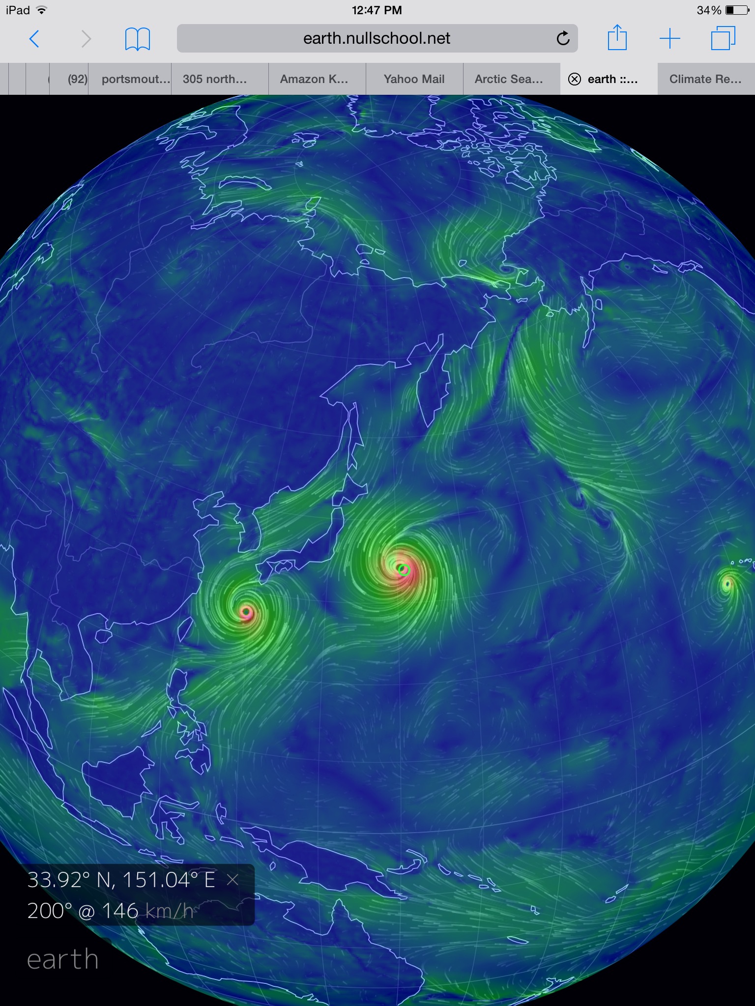
(GFS
model forecast graphically displayed by Earth Nullschool finds
typhoons Goni and Atsani running into wall of the Ridiculously
Resilient Ridge by Tuesday. It’s an atmospheric heat bleed from El
Nino to Arctic that, according to long range forecasts, has a risk of
carrying these strong storms with it. Image source: Earth
Nullschool.)
Over
the next few days, the typhoons are expected to turn north and
eastward. Goni is predicted to skirt the Philippines, Taiwan and
Japan. Atsani is expected to remain over open waters to the east of
Japan. Both are heading toward the hot, northward moving airs on the
backside of the Ridiculously Resilient Ridge.
Currently,
the Ridge is positioned over the Northeastern Pacific Ocean hot pool
just south and east of the Aleutians. It’s a strong and very deep
high pressure system that’s expected to maintain in the range of
1035 to 1040 mb over the coming days. It’s dredging up the hot El
Nino airs of the Equatorial Pacific and flinging them all the way to
the Arctic Ocean.
Atsani
is expected to plow into the back of this atmospheric wall of hot
airs and to then follow the warm flow northward — approaching the
Bering Sea edge by next Thursday as a powerful 960 to 970 mb
extra-tropical low with Goni’s remnants following in its wake.

(Forecast
sea level pressure map for Thursday, August 27th show Atsani’s
powerful remnants on a track for the Bering Sea and Alaska or the
Arctic Ocean. Image source:Climate
Reanalyzer.)
If
Atsani’s remnants enter the Bering as predicted, it will then
either track through Alaska or enter the southern Chukchi and
Beaufort Seas. At that point, the strength and disposition of the
Arctic high will determine its final path. If the high recedes closer
to Greenland and the Canadian Archipelago, Atsani’s extratropical
system could be projected into the Arctic Ocean proper as a late
season cyclone threatening the sea ice. If the Arctic high is more
centrally located, Atsani’s remnants would plow down into the
facing trough over Western and Central Canada — bringing with it
some very stormy weather.
A
Very Odd Storm Track
As
with last week, we continue to see this odd tendency for a storm
track to develop from the Western Pacific through to the Bering Sea,
Alaska, and the Arctic itself.
It’s a teleconnection-driven atmospheric dance between a powerful
summer El Nino, the hot blob of water over the Northeastern Pacific,
and the Ridiculously Resilient Ridge riding over top. With such a
pattern so firmly entrenched, there’s a risk that this storm track
will maintain well into Fall and, perhaps, persist into Winter with
Alaska as the destination for Pacific storms. Under such a pattern
there is little hope for drought-busting weather to reach California.
Which would mean a continuation of terribly dry conditions there
unless our Monster El Nino can somehow squash the extraordinarily
dogged RRR.
Meanwhile,
for the Arctic, the risk of powerful storms plowing through weak,
late season ice is looking a little bit less like an outlier event
and more and more like a possibility for end August. So we’ll have
to keep a close watch on Atsani, Goni, the RRR and the Arctic High.
Links:


