Showing posts with label storms. Show all posts

Wednesday, 2 March 2016

A winter of extremes in Britain

Gale After Gale After Gale Dumped Two and a Half Feet of Rain Upon Scotland and Wales This Winter


1 March, 2016

Reports from the UK Met Office are in. And we can say now with confidence that the UK have never seen weather like what they experienced this Winter. It looks like a storm track super-charged by climate change really socked it to the region this year. That we’ve just passed a winter worse than the then record years of 2013 and 2014 — only two years on.

A Stormy New Climate State for the North Atlantic

For the UK and for North Atlantic weather stability in general, the sea surface temperature anomaly signature in the graphic below is bad news. The cool pool just south of Greenland (indicated by the swatch of pale blue) is a new climate feature. One that appears to be related to glacial ice melt outflow from Greenland.

North Atlantic Sea Surface Temperatures
(10 degree Celsius above average sea surface temperatures off North America in today’s ensemble sea surface temperature model graphic are just insanely warm. Ocean surface anomalies used to rarely exceed 2 degrees Celsius warmer than average. These spikes off North America are an indication that the Gulf Stream is backing up and that overturning circulation off Greenland is slowing down. Image source: RTG-SST/NCEP /US National Weather Service/Earth Nullschool.)

Such melt outflow tends to slightly freshen sea surface waters. Freshening waters keep more heat locked into the ocean’s depths. They tend to cool the surface waters. And they slow down an ocean overturning circulation that, in the North Atlantic, drives the flow of the Gulf Stream.
A slowing Gulf Stream delivers less heat to this zone even as it piles more heat up off the North American Coast. As a result, a warm west, cool east dipole tends to develop. In the cool region south of Greenland, unusually strong storms have developed more and more frequently — with a dramatic impact on UK weather. The storms feed on this temperature differential even as they have gorged on heat and moisture streaming northward in a meridional flow over Western Europe. The results this year were nothing short of record-shattering.
Hottest and Wettest

For England and Wales, with temperatures ranging about 2 degrees Celsius above average for December, January and February, 2015-2016 probably beat out 2007 and 1989 as the hottest Winter on record. Meanwhile, Wales and Scotland saw the most rainfall ever recorded — with totals for both regions hitting around 756 millimeters or about two and one half feet. That’s even more rainfall than the previous record stormy Winter of 2013 and 2014.

Yet one more Gale
(Yet one more gale sets up to hammer Ireland, the UK and Scotland by Thursday. Four months of ongoing stormy conditions appears set to continue through to at least mid-March. Image source: NOAA’s Ocean Prediction Center.)

These heavy rains set off severe floods and damaged homes, roads, and bridges throughout the UK with the worst damage focusing in on regions to the North. One heavy precipitation hot spot — Argyll — saw an extraordinary 1035 mm or 3.5 feet of rainfall over the three month period. The Met Office is quick to point out that though December, January and February were the wettest on record since 1910, heavy rainfall events began in November — resulting in what amounts to a relentless four month pounding as storm followed storm and flood followed flood.

And, it appears, this persistent and ongoing storm pattern has not yet changed. For the North Atlantic remains riled — setting up to hurl a new gale-force low at Ireland and the UK this week. With the weather pattern essentially stuck in stormy since November, folks from these regions have got to be asking — when’s it going to end? As storms continue to fire off in the dipole zone above, it appears it will likely last until at least mid-March.
Links:
Hat tip to Colorado Bob
Hat tip to TodaysGuestIs
Hat tip to Dan Combs


Tuesday, 26 January 2016

Extreme conditions across the globe


Deaths in Japan and Taiwan as record cold snap hits east Asia

At least 95 people die as record-low temperatures in region bring snow and ice cause flight cancellations and leave thousands stranded


25 January, 2016

Snow, sleet and icy winds across east Asia have caused deaths, flight cancellations and chaos as the region struggles with record-low temperatures due to an Arctic cold snap that brought snow to several tropical areas for the first time in many people’s lifetimes.

In Taiwan, the capital Taipei recorded a low of 4C (39F), the coldest in 44 years. Local media said 90 people had died due to the cold weather, mainly from hypothermia and cardiac arrest. Five more died in Japan.

Hundreds of flights were cancelled across the region, tens of thousands of holidaymakers were stranded in South Korea, and freezing conditions in sub-tropical Hong Kong caused mayhem on its tallest peak.

In northern Vietnam, snow blanketed mountain areas as the wave of cold air arrived on Sunday to Lào Cai province. In the capital, Hanoi, it dropped to a milder 6C, although authorities said that was the coldest the city has been for two decades.

The southern Chinese city of Guangzhou, which is by the tropic of Cancer, saw sleet for the first time in 60 years, the local meteorological station said. Residents posted photos online of small snowmen they had made, quickly constructed from a thin layer of icy flakes that fell on cars and road.

A Guangzhou driver, Wang Jun, told the South China Morning Post that he had never seen sleet throughout his 20 years working in the city. “I woke up at 6am to work and saw small pieces of ice hit my windscreen. It stopped for a while, but happened again half an hour later. And then there was sleet at about 11am,” he said.

It’s the first time I’ve see that. It’s very beautiful,” he said.

The cold was caused by a polar vortex, a large cyclone that pushed south from Siberia and unusual meteorological occurrence for east Asia.

In Hong Kong, primary schools and kindergartens were closed on Monday after temperatures fell to 3C, a 60-year low. A 100km ultra-marathon race was abandoned as competitors crossing the city’s tallest peak, Tai Mo Shan, slipped on icy slopes buffeted by freezing winds. A race official described the scene as one of “carnage”, with dozens of people suffering from hypothermia; firefighters called in to rescue them were filmed slipping and sliding on the icy road.

In Bangkok, labelled the planet’s hottest city by the World Meteorological Organisation for its mean air temperature of 28C, the mercury dropped to 16C on Monday. Scarves and padded jackets, normally bought only as winter holiday items by residents of Bangkok, appeared in the city as locals dealt with the unusually cool weather.

During the peak tourism season, the sea in many areas was dark and rough as grey clouds hung overhead.

Hundreds of flight cancellations left tens of thousands of holidaymakers stranded in South Korea, after the biggest snowfall in three decades shut the airport on the resort island on Jeju.

In China, 24 weather stations recorded all-time low temperatures. Further north, in Inner Mongolia, the temperature dropped to a record low of -46.8C (-52F) and in China’s eastern city of Qingdao, fishing boats were stuck fast in the frozen waters.

The weather ruined many people’s travel plans for the Chinese lunar new year season, when families normally travel to their home towns.


If you never read any science, or if you're a complete idiot, you might think this was "evidence" of a coming ice age.

Never mind the fact that it's raining and temperatures are 55F higher than what they should be.

Perhaps all the evidence is being fabricated. Lol.


But if you're open to looking at  things rationally and open to a  bit of science, paul Beckwith can put it into context

Arctic Ocean Blowtorch Attacks Sea-Ice

Our climate system has destabilized. Our fossil-fueled emissions have changed the chemistry of our atmosphere and our oceans, changing the heat balance between the equator and Arctic. This has fractured the jet streams, and brings us closer to a new planet with zero snow and ice in the Arctic. Here is what is happening...


Or this...

Blizzard Jonas and the slowdown of the Gulf Stream System


Blizzard Jonas on the US east coast has just shattered snowfall records. Both weather forecasters and climate experts have linked the high snowfall amounts to the exceptionally warm sea surface temperatures off the east coast. In this post I will examine a related question: why are sea surface temperatures so high there, as shown in the snapshot from Climate Reanalyzer below?


Or this... From Jason Box

'If anything, climate sensitivity is higher'-Glaciologist Jason Box on climate sensitivity


Back to the news stories


As Hong Kong emerged into the crisp sunny day today after its record-setting cold snap on Sunday areas around the world were experiencing unseasonal weather. 

In Melbourne, Australia summer’s extreme heat gave way to relatively cold weather, as the United States dealt with record snowfall in a blizzard. Even New Delhi in India battled through a wave of cold weather; the minimum temperature in the often steamy city was just 4.2 degrees Celsius on Friday, below


Japan snowstormTOKYO, Jan. 24 (Xinhua) — Five people died and scores have been injured, as swathes of western and central Japan on Sunday saw record amounts of heavy snowfall blanket town and cities.


The snow caused major disruption to transportation networks, with hundreds of flights canceled and bullet trains services suspended. Conditions are likely to worsen

Polar vortex hits Hong Kong: new records as temperatures plummet towards zero, weather bureau promises more cold to come


Blizzard and hurricane winds kill 19 people in north-eastern US states


Some were killed in car accidents, three died shovelling snow in New York City and two of hypothermia in Virginia


While the el-Nino is live and well in the Pacific....


Monday, 25 January 2016

North Pole unfreezing for a seond time this winter

Warm Arctic Storms Aim to Unfreeze the North Pole Again — That’s 55 Degrees (F) Above Normal For January


23 January, 2016
It’s worth re-stating. The Starks were wrong. Winter isn’t coming. Winter, as we know it, is dying. Dying one tenth of a degree of global oceanic and atmospheric warming at a time. Steadily dying with each ton of heat-trapping greenhouse gasses emitted through our vastly irresponsible and terrifyingly massive burning of fossil fuels.
******
According to UCAR reanalysis, it’s something that’s only happened three times during December in the entire temperature record for the North Pole since the late 1940s. Four times now that a record warm surge of air hit that highest point of Northern Hemisphere Latitude during late December of 2015An event that was influenced by the very destructive Winter Storm Frank. A combination of weather variables that, by themselves, was odd and rare enough. But what may be about to happen next week is even more rare. Because we’ve never, not once, seen this kind of heat set up at the North Pole during January.
UCAR North Pole
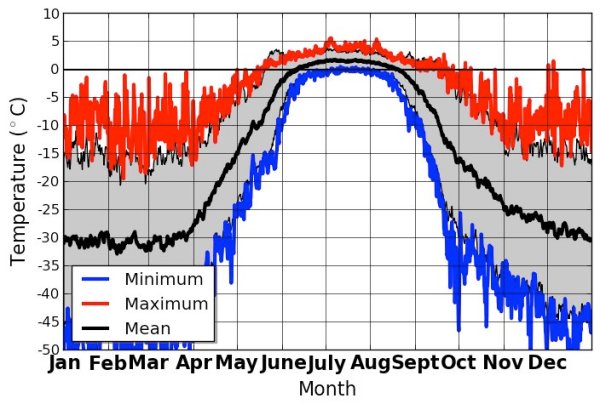
(UCAR’s North Pole temperature data record since 1948 per Bob Henson shows no above freezing days at the North Pole during January through late April. But it could happen next week.)

Disturbingly, what we’re seeing now starting to take shape is another warm air invasion of the Arctic with the potential to bring above-freezing temperatures to the North Pole during the long polar night. An odd and highly abnormal event that may again take place this Winter in just a few more days. If it does happen it will be yet another case of a never-before-seen warming event occurring in a record hot world.
North Pole May Unfreeze A Second Time This Winter

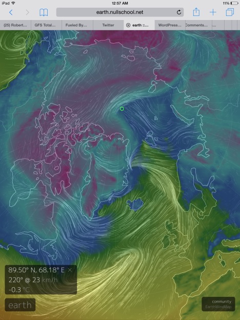
According to Global Forecast Systems model reanalysis by Earth Nullschool, it appears that a record warm Earth atmosphere and ocean system is again taking aim at the High Arctic. Another synoptic daisy chain of storms funneling warm, south-to-north winds — dredging them up from the tropics, flinging them across thousands of miles of North Atlantic Ocean waters, driving them up over Svalbard and toward the North Pole — is predicted to set up by early morning Monday.

image
(Temperatures are predicted to warm into a new record range for the North Pole by late Tuesday. Readings that strike very close to freezing at the North Pole now appear in the most recent Global Forecast System model summary by Earth Nullschool. If temperatures in this region do hit above freezing, it will be an unprecedented event. Image source: Earth Nullschool. )

The anchor of these dervishes of Equator-to-Pole heat transfer is the very Winter Storm Jonas that just crippled the Eastern US with record snowfall amounts and storm surges that have beaten some of the highest seas seen during Superstorm Sandy. A second, hurricane force low in the range of 950 mb is predicted to set up between Iceland and Greenland. But the tip of this spear of record atmospheric heat pointed directly at the Arctic is a third, but somewhat milder 990 mb, storm.
And it is this northern low that will draw a leading edge of record warmth into the Arctic. An anomalous, ocean-originating heat front that will spread its pall of air warm enough to melt sea ice during Winter north of Svalbard tomorrow. A swath of near and above-freezing temperatures spreading inexorably Pole-ward. Reinforced by the supporting lows and the synoptic wave of warmth in train, this storm is predicted to drive near or slightly above freezing temperatures into the region of 90 North Latitude by late Tuesday or early Wednesday. An event that would be unprecedented, at least in modern meteorological reckoning. One that may well be unprecedented for the whole of the Holocene.
Conditions in Context — Another Summer-Type Heatwave For The Arctic During the Long Dark of Winter

Another Wave of Extreme Arctic Heat
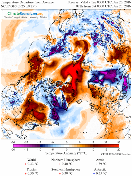
(Another wave of extreme, above average temperatures for the Arctic is on the way. Image source: Climate Reanlyzer.)

To put such extraordinary temperatures into context, this predicted record polar warmth is in the range of 55 degrees (F) above normal for January. And for such a typically frigid region, these temperatures are more usual for June, July, or August. Or, to make another comparison, for Gaithersburg, Maryland it would be like seeing readings above 94 degrees (F) for the same Winter day. A summer heatwave in the midst of what should be a season of cold. That’s what’s predicted for a region that will not see a single ray of sunlight until April.
Heat trapping gasses with the ability to re-radiate the sun’s energy in the dark of night or in the depths of Winter are now having a profound impact on our world. It’s something that should really be keeping us up at night. At the very least, it’s something that on Tuesday may push the North Pole up above freezing on a, black as night, January day.
Links:
Earth Nullschool
UCAR Climate Reanalysis
Hat Tip to Greg


Saturday, 9 January 2016

Tropical Storms Are Now Forming During Winter

See this discussion below from Robertscribbler's Facebook page testifying to his addiction to Hopium.

This is What the Athropocene Looks Like — Tropical Storms Are Now Forming During Winter


8 January, 2015
Tropical Storms in both the Atlantic and Pacific during January. It could happen this week. And it’s all due to this new Anthropocene weather we’re now experiencing.
*****
The Holocene ended more than half a century ago. That’s when human impacts from the production of plastics, to the use of nuclear materials, to the forcing of species extinction,became what scientists now believe to be the dominant influence on this era of Earth history. It was also the time when human beings were in the process of plotting a course to radically alter the Earth’s climate. Pumping greenhouse gasses into the global environment at the fastest pace ever recorded in the geological record. Setting the stage for a warming event not seen in millions of years and, perhaps, in all of time on this world. One that would fundamentally alter the geophysical nature of the Earth system from the bottom of the oceans to the top of the atmosphere.

And it sure does feel like it — with the North Pole now experiencing above-freezing temperatures during Winter and with both the Atlantic and the Pacific retaining enough heat and instability to brew up tropical cyclones during January.
Unprecedented Tropical Cyclone Development in Both the Pacific and the Atlantic During January

It’s really a bit of an understatement to say that January is not a month where we usually see tropical cyclone formation in the Northern Hemisphere. Back in the 1870s it happened in the Atlantic. Once. In the Pacific, which tends to host sea surface temperatures that are hotter than those in the Atlantic, the various basins can sometimes see these beasts blow up early on in the year. Sometimes meaning that two have only ever been recorded during January — Winona on January 9 of 1985 and Ekeka on January 26 of 1992.

Since climatology is the understanding of trends in average weather over long periods, we can probably say that the off-season tropical cyclone climatology has already changed for the Pacific. During the 148 years since record keeping began in 1832 for the Pacific through to 1980 only seven tropical cyclones were recorded to have formed during the period of December through May. During just the 35 years since 1980, we’ve seen nearly twice that many — 12. In other words, the rate of recorded off-season storm formation septupled or increased a factor of 7. And both the earliest and the latest named stormed have now formed during back-to-back years — Nine C on New Years Eve less than two weeks ago and now Pali on January 7th.

What we are seeing now is unprecedented by any measure of tropical weather system climatology. We have never seen a tropical storm form so early in the Central Pacific at the same time during which a similar, very rare, tropical system was threatening to form in the Atlantic. In other words, it’s not just both events in isolation that’s quite odd. It’s the fact they are both happening side-by-side.
Pali — Earliest Tropical Cyclone to have Ever Formed in Central Pacific

Pali, in particular, is an unusual beast. According to Weather Underground, as of early this morning Pali was whipping up 65 mile per hour winds and rough surf along a broad region of water some 1350 miles southeast of Hawaii. Pali spun up out of a westerly wind burst and storm pattern associated with the monster El Nino now going off in the Pacific. But even during past super El Ninos, related odd tropical systems have tended to form mainly during late November through to mid December. The formation of Pali is then possibly associated with both this late peaking El Nino and with sea surface temperatures in the Pacific that are now among the hottest ever seen in human reckoning.

Pali projected path
(According to today’s National Hurricane Center forecast, Pali could stick around for quite some time. This record earliest Pacific cyclone could last into the middle of January — spinning out westerly winds that aid in the maintenance and possible re-intensification of the current super El Nino. Image source: NOAA’s Central Pacific Hurricane Center.)

Pali is expected to meander along the Central Pacific equatorial region in which it formed over the next six days. It is predicted to maintain tropical storm intensity throughout this period — making it a rather long-lasting weather system. Expected to re-curve back toward the Equator near the 175 West Longitude line, the strong westerlies associated with Pali could also aid in maintaining or even increasing the strength of our current super El Nino — driving warm water up-welling in the Eastern Pacific to reinvigorate. Sea surface temperatures in the range of 27 to 28 degrees Celsius are more than enough to maintain tropical storm intensity. Meanwhile, sea surfaces in the range of 3-4 degrees Celsius hotter than normal just to the southeast of Pali will continue to provide considerable moisture for the storm to feed upon. Wind shear, therefore, is the only major limiter for Pali. And though shear appears to be strong enough to preclude Pali’s development into a typhoon, it is not at this time predicted to become intense enough to disperse Pali. So, if the forecast is correct, we’re looking at this storm sticking around for at least another week.

30 Percent Chance of Tropical Cyclone Development in the Atlantic During January


As if Pali and this ramping trend of off-season tropical cyclone formation in the Pacific weren’t enough to put an exclamation point after the sentence — tropical storms are forming earlier than they used to — we have a concordant potential tropical cyclone development happening at the same time in the Atlantic. A weird storm is taking on extra-tropical characteristics off the US East Coast. Already packing gale-force winds in the range of 60-65 miles per hour, this odd system now has the potential to become a warm-core, tropical low as it moves eastward toward the Azores.
The storm now sits over sea surface temperatures in the range of 23-26 degrees Celsius. That’s much, much hotter than normal (2 to 8 degrees Celsius above average) for that region of the North Atlantic for this time of year. It’s also in the range that’s generally considered just about enough to support tropical storm and even possibly hurricane formation. Subsequently, the National Hurricane Center sees the potential for a warm core formation in this system and has given it a 10 percent chance of becoming a tropical storm over the next 48 hours.
Odd North Atlantic System Potential Tropical Storm
(Very odd North Atlantic Gale rages over record warm waters in the North Atlantic. This system now has a 10 percent chance to develop into a tropical cyclone over the next 48 hours. Over the next five days, the chance of tropical cyclone development jumps to 30 percent. Image source: The National Hurricane Center.)

This freakish system is then expected to skirt the southern edge of a powerful low between the UK and Greenland. Tracking eastward toward Africa, its winds are predicted to further intensify as it heads toward somewhat warmer waters. Over the next five days, the National Hurricane Center gives a moderate chance (30 percent) that this system will form into a tropical cyclone.
As noted above, such weather patterns are not at all normal for the North Atlantic. And if a hurricane or tropical storm did form during January in the North Atlantic it would be the first time since 1872. Again it’s a case of we’ve never seen weather like this before. We’ve never seen hurricanes so early in the Central Pacific. We’ve never seen sea surface temperatures so warm during Winter off the US East Coast. And we’ve never seen the potential development of a January Atlantic tropical system at the same time such systems are riling the waters of the Equatorial Pacific.
The scientists were absolutely right. The Holocene is over. We’re living on a different planet.
Links:
Hat Tip to Colorado Bob
Hat Tip to Caroline
Hat Tip to DT Lange
I
In the comments section of the article Robertscribbler showed himself to be pretty "hopeful" about COP21 even when his hero and mentor, James Hansen is not.


This seems to be part and parcel of being a pro-growth, pro-Obama liberal, which I find pretty offensive.

A pity, because I find Robertscribbler one of our best environmental journalists.

My own comment was this: 
I would have thought that if we were intellectually honest we would take all the evidence together (from ALL disciplines) to draw conclusions about where humanity is headed. It is not a case of "giving up" but of conflict ting the implication of the knowledge we have. Conclusions should follow from the evidence, not from whether the conclusions are "productive" of not. I understand why people tal about hopium.

Robertscribbler There's this tendency to attack COP 21 which is pretty counter-productive. What we should be saying about COP 21 is that it was progress, but that it wasn't enough of a commitment yet to deal with the problem adequately. If we go back to COP 22 and get...See More
LikeReply610 hrs
Robertscribbler The current global path is for a 40 percent GHG reduction by 2030 and a 75 percent reduction by 2050. That's a pretty big commitment. And though it's not yet enough to miss 2 C with a high level of certainty by this Century it's a much, much stronger c...See More
LikeReply27 hrs
Kevin Hester Voluntary reductions are the reductions you have when you don't have reductions. Factor in the melting permafrost and disasters like the methane catastrophe in California and all we are doing is listening to the band on the deck of the Titanic long after the point of no return. Brace for imminent impact
LikeReply37 hrs
Robertscribbler Robert Dupuis The conference commits to broad reductions goals, not to specific pathways. That's for the individual countries. So of course it's not going to mention a specific method. I'm sorry to say, but it seems you've been somewhat misinformed.
LikeReply17 hrs
Robertscribbler Kevin Hester Well, if you want to give up. Build a ship called the Titanic, go sail it toward an iceburg, and go play with the band. But for those of us interested in actually making a difference -- that means holding governments and businesses account...See More
LikeReply17 hrs
Kevin Hester I haven't given up Robert, far from it. I am doing what I would do on a ship.
I have completed 16 ocean passages on yachts, over half as a skipper. As a skipper I must declare when a ship is sinking and not pretend that the situation is fixable when it...See More
LikeReply27 hrs
Robertscribbler Michael Green Again we have a great degree of misunderstanding as to what the climate conference actually is. It's not global government. It's a meeting of governments. So it's up to the governments themselves to turn the agreement into policy. In a wa...See More
LikeReply17 hrs
Robertscribbler Kevin Hester I think, Kevin, that your mixing of metaphors doesn't apply here in the least. The ship has not sunk. We are all here. We are all still alive. And we all still have choices. And the best choice we could make now is to reduce emissions as rapidly as possible. Not rant endlessly about why we should all just give up.
LikeReply17 hrs
Robertscribbler Dupuis, McNulty, Kevin, Mcpherson, Doomerism doesn't live here. I'm very sorry about your current depression. But I'm not buying it. I'm doing what I can to save people's lives and I'm sad, but not surprised, that you're not doing the same.
LikeReply7 hrs
Kevin Hester I have never advocated giving up. My position is based on living in the reality of where we are at.
Yelling fire in a burning theatre is a duty, pretending it is being dealt with when it patently isn't is dereliction of that duty
LikeReply37 hrs
Robertscribbler Luke Orsborne You tear down current civilization, and there's no hope for effective, mass-level response. In fact, it's the degradation of group-action structures and blocking of those structures that has caused this problem in the first place. If you...See More
LikeReply6 hrs
Kevin Hester Industrial civilisation is the problem and can't be a part of the solution.
One of the reasons we have destroyed this planet is because we are so human centric, it's not and should not always be about us.
LikeReply16 hrsEdited
Robertscribbler You've fallen into an ideological trap, Kevin. You've conflated industrialism with fossil fuel use and carbon emissions. The center of gravity here is fossil fuels. And, oddly enough, your attacks here are defending them.
LikeReply6 hrs
Robertscribbler An interesting ideological point of view. But if you want to deal with the greenhouse gas crisis. If you want to reduce the harm coming down the pipe. It's pretty simple. Stop emitting greenhouse gasses. All this other ideation is simple distraction. O...See More
LikeReply6 hrsEdited
Robertscribbler Way off topic, Luke. Way, way, way off base.
LikeReply5 hrs
Kevin Hester Respectfully I agree with Luke and believe the issues are intrinsically linked.
UnlikeReply25 hrs
Robertscribbler It's ever-so easy to wrap a false premise -- doomerism -- in the truth. It's ever-so easy, apparently, to ignore the fact that the center of gravity to the whole carbon emissions problem is carbon emissions. Sure, modern civ has other problems. And we...See More
LikeReply4 hrs
Wendy Bandurski-Miller Respectfully how the social/political/government response to a world climatic disruption issue be solved outside and separate from the culture in which it was spawned?

I consider *way off topic* to be code for reductionist thinking because quite fra...See More
UnlikeReply24 hrs
Robertscribbler Wendy Bandurski-Miller Actually, no. If we'd had COP 21 30 years ago, we'd have been in much better shape. What got us where we are now is this divisive attitude. This notion that nothing can be done. The notion that human civ deserves collapse and that people, somehow, deserve to suffer. That's pretty reprehensible, really.
LikeReply4 hrs
Wendy Bandurski-Miller If we'd had COP 21 30 years ago, we'd have been in much better shape - so 1985? the year the Rainbow Warrior was SUNK?

*Is this divisive attitude?* actually i am ALL about putting the here and now in context....not separating it into separate scien...See More
UnlikeReply13 hrsEdited
Michael Green >Why is there so much opposition to COP21? I'd bet that it's because if it is actually fully implemented, even as it, it means the fossil fuel industry basically doesn't exist anymore. It means this industry goes through a series of crashes.

The iron...See More
LikeReply12 hrs
Robin Westenra
Write a reply...
Guy McPherson James Hansen correctly called COP21 a "fraud" and "bullshit." Bill McKibben said it will leave us with a planet that is "uninhabitable." Apparently honesty is counterproductive.
LikeReply94 hrsEdited
Robertscribbler Hansen's peeved. And rightly so. He warned people back in 1989 and has been fighting like hell for a great carbon emissions reduction policy that has basically been ignored ever since. But I think what's missed in all the big words and explosions and d...See More
LikeReply17 hrs
Robin Westenra I would have thought that if we were intellectually honest we would take all the evidence together (from ALL disciplines) to draw conclusions about where humanity is headed. It is not a case of "giving up" but of conflict ting the implication of the knowledge we have. Conclusions should follow from the evidence, not from whether the conclusions are "productive" of not. I understand why people tal about hopium.
UnlikeReply43 hrs
Rick Hill There is little doubt, irrespective of any " consensus... 😀
LikeReply34 hrs
Michelle Walters cop21 IS bullshit! it's late to mince words.
UnlikeReply23 hrs
Rick Hill OMG
LikeReply39 hrs
Kevin Hester Anthropogenic climate disruption, get used to it, there is no normal any more.
UnlikeReply77 hrs
Marc Haneburghthttps://www.facebook.com/100010385239407/videos/vb.100010385239407/142362276119946/?type=2&theater
1,308 Views
Marc Haneburght
A 3 1/2 min Video."The Its All OK Climate Rap Video".Talk is cheap + a climate denier fun section.
Of course Professor Guy McPherson is in the video,the only truth teller.
Enjoy.
UnlikeReply26 hrs
Marc Haneburghthttps://www.facebook.com/100010385239407/videos/vb.100010385239407/148735785482595/?type=2&theater
55 Views
Marc Haneburght
3 1/3 min Radio Excerpt *** Info for People Just Realizing the Dangers of Abrupt Climate Change
Climate expert spokesman/activist Kevin Hester gives some impor...
See More
UnlikeReply46 hrs
Terry Bennett The last article I read about the Anthropocene Era noted that this is just a theory. This article seems to be sure it has started. I wonder what the majority of the scientific community believes.
LikeReply7 hrs
Robertscribbler Read the linked article by the Guardian. Consensus is building. The Holocene is over.
LikeReply17 hrs
Michael Green @Robert DeWit: Giving up was a term used by John Wayne. It's loaded with everything from George Lucas to Disney Studios. You "believe in overshoot," you say. Do you have any idea what it is? Do you have any idea why the good people at COP-21 failed to ...See More
LikeReply32 hrsEdited
Andrew DeWit Robertsribbler is a treasure of news and critical insights into the most important crisis of our time. Excellent work. Always deeply informative, without exaggeration (which is indeed unnecessary and counterproductive, but some want to slather on).

Here is another conversation - 


Guy McPherson James Hansen correctly called COP21 a "fraud" and "bullshit." Bill McKibben said it will leave us with a planet that is "uninhabitable." Apparently honesty is counterproductive.
LikeReply94 hrsEdited
Robertscribbler Hansen's peeved. And rightly so. He warned people back in 1989 and has been fighting like hell for a great carbon emissions reduction policy that has basically been ignored ever since. But I think what's missed in all the big words and explosions and d...See More
LikeReply17 hrs
Guy McPherson As we've known for years, only collapse of civilization prevents runaway climate change. That's what I work toward, and not merely to prevent runaway climate change (there are many aspects of civilization that are omnicidal).
UnlikeReply87 hrs
Anke Hagen I agree 100% with you Guy. What would be interesting however is a blueprint as to how this would work (*exactly*) for 7 billion humans. We need a 'how to' manual. That would be a fantastic project for you and Kevin to work on!
LikeReply46 hrs
Vernon Brechin My impression was that even though COP21 may have advanced the goals they didn't come up with strong incentives, or other means, to achieve anything close to even the 2.0°C limit goal. - Patting each other on the back for achieving an agreement is not a very effective motivator.
LikeReply46 hrsEdited
Rick Hill Two degrees is baked in the cake! We are now working to save highly complex forms of life... The COP is no where near adequate... We need a bloody miracle at this point...
LikeReply34 hrs
Robin Westenra I find it fascinating to see how it is possible to write so accurately about abrupt climate change and be so "hopeful" about the charade that was COP21. Hansen didn't describe it as "bullshit" for nothing.