Warm Arctic Storms Aim to Unfreeze the North Pole Again — That’s 55 Degrees (F) Above Normal For January
23
January, 2016
It’s
worth re-stating. The Starks were wrong. Winter isn’t coming.
Winter, as we know it, is dying. Dying one tenth of a degree of
global oceanic and atmospheric warming at a time. Steadily dying with
each ton of heat-trapping greenhouse gasses emitted through our
vastly irresponsible and terrifyingly massive burning of fossil
fuels.
******
According
to UCAR reanalysis, it’s something that’s only happened three
times during December in the entire temperature record for the North
Pole since the late 1940s. Four
times now that a record warm surge of air hit that highest point of
Northern Hemisphere Latitude during late December of 2015. An
event that was influenced by the very destructive Winter Storm Frank.
A combination of weather variables that, by themselves, was odd and
rare enough. But what may be about to happen next week is even more
rare. Because we’ve never, not once, seen this kind of heat set up
at the North Pole during January.
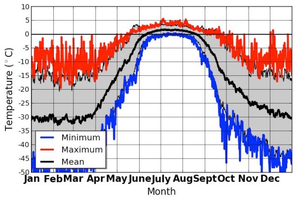
(UCAR’s
North Pole temperature data record since 1948 per Bob
Henson shows
no above freezing days at the North Pole during January through late
April. But it could happen next week.)
Disturbingly,
what we’re seeing now starting to take shape is another warm air
invasion of the Arctic with the potential to bring above-freezing
temperatures to the North Pole during the long polar night. An odd
and highly abnormal event that may again take place this Winter in
just a few more days. If it does happen it will be yet another case
of a never-before-seen warming event occurring in a record hot world.
North
Pole May Unfreeze A Second Time This Winter
According
to Global Forecast Systems model reanalysis by Earth
Nullschool, it
appears that a record warm Earth atmosphere and ocean system is again
taking aim at the High Arctic. Another synoptic daisy chain of storms
funneling warm, south-to-north winds — dredging them up from the
tropics, flinging them across thousands of miles of North Atlantic
Ocean waters, driving them up over Svalbard and toward the North Pole
— is predicted to set up by early morning Monday.
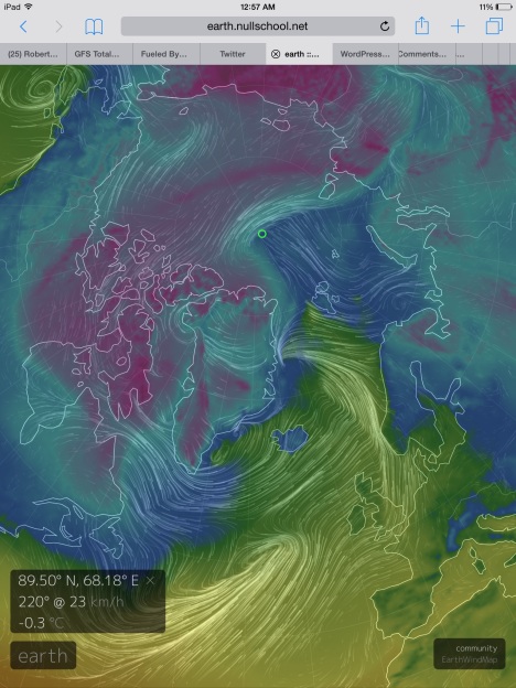
(Temperatures
are predicted to warm into a new record range for the North Pole by
late Tuesday. Readings that strike very close to freezing at the
North Pole now appear in the most recent Global Forecast System model
summary by Earth Nullschool. If temperatures in this region do hit
above freezing, it will be an unprecedented event. Image
source: Earth
Nullschool.
)
The
anchor of these dervishes of Equator-to-Pole heat transfer is the
very Winter Storm Jonas that just crippled the Eastern US with record
snowfall amounts and storm surges that have beaten some of the
highest seas seen during Superstorm Sandy. A second, hurricane force
low in the range of 950 mb is predicted to set up between Iceland and
Greenland. But the tip of this spear of record atmospheric heat
pointed directly at the Arctic is a third, but somewhat milder 990
mb, storm.
And
it is this northern low that will draw a leading edge of record
warmth into the Arctic. An anomalous, ocean-originating heat front
that will spread its pall of air warm enough to melt sea ice during
Winter north of Svalbard tomorrow. A swath of near and above-freezing
temperatures spreading inexorably Pole-ward. Reinforced by the
supporting lows and the synoptic wave of warmth in train, this storm
is predicted to drive near or slightly above freezing temperatures
into the region of 90 North Latitude by late Tuesday or early
Wednesday. An event that would be unprecedented, at least in modern
meteorological reckoning. One that may well be unprecedented for the
whole of the Holocene.
Conditions
in Context — Another Summer-Type Heatwave For The Arctic During the
Long Dark of Winter
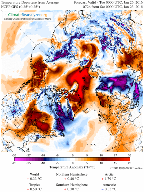
(Another
wave of extreme, above average temperatures for the Arctic is on the
way. Image source: Climate
Reanlyzer.)
To
put such extraordinary temperatures into context, this predicted
record polar warmth is in the range of 55 degrees (F) above normal
for January. And for such a typically frigid region, these
temperatures are more usual for June, July, or August. Or, to make
another comparison, for Gaithersburg, Maryland it would be like
seeing readings above 94 degrees (F) for the same Winter day. A
summer heatwave in the midst of what should be a season of cold.
That’s what’s predicted for a region that will not see a single
ray of sunlight until April.
Heat
trapping gasses with the ability to re-radiate the sun’s energy in
the dark of night or in the depths of Winter are now having a
profound impact on our world. It’s something that should really be
keeping us up at night. At the very least, it’s something that on
Tuesday may push the North Pole up above freezing on a, black as
night, January day.
Links:
Earth
Nullschool
UCAR
Climate Reanalysis
Hat
Tip to Greg


No comments:
Post a Comment
Note: only a member of this blog may post a comment.