Showing posts with label jetstream. Show all posts

Saturday, 20 February 2021

"Wavy Jet Stream Underlies Texas Storm"

This is the story but (in my humble opinion) NOT the entire story

Review: Arctic Temperature Amplification Influence on Polar Vortex Causing Severe Winter Weather

Paul Beckwith

In my last few videos I discussed the brutal cold snap that has extended downward in the USA, as far south as the Mexican border and the Gulf of Mexico. It temporarily wiped out about 1/3 of the Texas power grid, plunging 4.5 million Texas households into extended cold and darkness. If you assume that each household has an average of 3 people, that’s 13.5 million people. As bad as it was, it came very close to knocking out the entire state power grid. In this video I get into the scientific details on how abrupt climate system change has warmed the Arctic much faster than the lower latitudes (Arctic Amplification) and this in turn is leading to frequent disruptions of the polar vortex. I discuss a review paper that examines the various process that lead to observations of slowing and wavier (more meridional) Jet Streams, which are in turn leading to more likely Sudden Stratospheric Warming which then fractures (splits) the polar vortex causing cold Arctic air to spill far southward in North America and in Eurasia. Essentially, the Arctic is warming like crazy on its own. This warming near the surface and near the troposphere-stratosphere border region of the Jet Streams is rising even higher into the stratosphere fracturing the stratospheric polar vortex. Consequently, the cold Arctic air spills southward. Of course, when you think about it, massive amounts of cold air moving from the Arctic to the deep southern latitudes is simply another manifestation of a greatly warming Arctic, since the cold air lost there in the far North is replaced by warmer air moving into the far north. Of course, most people have not cared in the least that the Arctic is warming like crazy. However, they do care, even in Texas, when the Arctic breaks and the cold Arctic air spills into their cities and takes out their power grid.  

I can guarantee you that people will care, when the broken Arctic disrupts the global air circulation and ocean circulation patterns enough to take out much of the global food supply in the near future, as we plunge towards a total loss of summer Arctic sea ice BOE (Blue Ocean Event). 

From an armchair ecologist


Science Update: Arctic Permafrost, Mines Releasing Carbon

Saturday, 18 July 2020

Zack Labe: The waters round the North Pole are likely to be open water until fall

The melting of Arctic ice, the weakening jetstream and floods – is there a connection?
This is the tweet I woke up to this morning. The fairly cautious Zack Labe is saying the whole area surrounding the Central Arctic Basin could be open water while in the past it never was.

This could be my own response to this .


Here you can see exactly what he is talking about here, The only area that is not essentially ice-free is above the Canadian archipelago and Greenland, although even there the ice is retreating from the coastline.
It has been speculated that Greenland waters could be colder because of run-off from melting Greenland glaciers.

Another view from the same source (the University of Bremen)

This is a global view of the rain on the planet. One would be excused for thinking this is everywhere. Weather patterns (such as the floods in China) seem to be just sitting there and not moving on.

The northern hemisphere Jetstream has both weakened and broken up.


This is a global view. The southern Jetsteam is a lot stronger but also breaking up.


There are flood events all around the world.  Here are just a few (courtesy of the Watchers)


This report is from Singapore. I doubt if I will see it in the global mainstream media but particularly in the NZ media.

Sunday, 20 January 2019

The Polar Vortex Is Collapsing

The Polar Vortex Is Collapsing — Here's What That Means for Your Winter Weather

By Tom Metcalfe, Live Science Contributor


Live Science,

18 January, 2019


A simulated image of the stratospheric winds over the North Pole Jan. 18, 2019, showing how the northern polar vortex has split into two major parts – one over Canada and one over Russia.


The blast of Arctic weather headed for the United States this weekend could be a first sign of still worse things to come this winter, with signs that a circular low-pressure system of swirling winds that normally keeps frigid air locked up at the North Pole has been disrupted and split into smaller parts.

The disruption in this counterclockwise-spinning beast, called the polar vortex, is thought to be caused in part by a warm summer over the Arctic and a relatively cold fall over Siberia. The result for the United States and northern Europe? A severe winter lasting throughout February and possibly into March.

Meteorologist Judah Cohen agreed that the breaking up of the polar vortex could be the culprit for the coming storm. Cohen, the director of seasonal forecasting for the weather risk management company Atmospheric and Environmental Research (AER), based in Lexington, Massachusetts, told Live Science that the coming snowstorms in the United States this weekend are consistent with weather models that predicted severe wintry weather to come in the coming weeks. [Infographic: Earth's Atmosphere Top to Bottom]

The weather models suggested that the disruptions would follow the pattern of polar vortex disruptions seen during the northern winter last year, which resulted in freezing weather across the United States in December and January, and a severe cold snap in March over the United Kingdom.
"This pattern looks much more active, [with] more winter type storms and Arctic outbreaks — I think I would attribute it to definitely being a polar vortex disruption, because it is very consistent with what we've seen in the past," Cohen said.

Polar winds

The northern polar vortex is a fast-flowing stream of air that circles the North Pole in the upper parts of the atmosphere, known as the stratosphere, about 20 miles (32 kilometers) above the surface.

A similar polar vortex exists over the South Pole, but it is the northern polar vortex that can bring severe winter weather to the United States and Europe.
When the northern polar vortex is strong, Cohen explained, it keeps most of the air cooled by the Arctic in the polar region, resulting in mild winter temperatures in the middle latitudes of the eastern United States, and in northern Europe and Asia.
But when the polar vortex weakens, the once-trapped cold air can meander throughout the top of the Northern Hemisphere, bringing polar temperatures and extreme winter weather to lower latitudes, he said.

This diagram shows the normal activity of the northern polar vortex (left) and what happens when the polar vortex weakens.
Credit: NOAA 

"Think of the polar vortex as a spinning top, and where the polar vortex goes so goes the cold air," Cohen said. "A strong polar vortex is a fast, tightly spinning top centered over the North Pole, keeping all the cold air with it close by over the Arctic. [But] a weak or perturbed polar vortex is a spinning top that has been banged or bumped into an object multiple times … the top slows down and wobbles and can meander from its location."
As for what knocked into this spinning top, Cohen points, in part, to summer warming in the Arctic region and a relatively cold fall in Siberia.
"I have argued that Arctic change has certainly been a contributor," he said. "The loss of sea ice, especially in the Barents and Kara seas, which are near Scandinavia in north-west Russia … and also an increasing trend in Siberian snow cover in October, I think that has also been contributing.

Winter weather

In recent days, weather scientists have seen the northern polar vortex split into three smaller parts, which have now changed into two giant patches of polar winds in the stratosphere — one over northern Canada and one over central Russia.

Snowstorms have been forecast today (Jan. 18) and tomorrow (Jan. 19) for the central Plains and Midwest of the United States, as part of what's being called winter storm Harper; and the winter weather is expected to hit the mid-Atlantic and Northeast of the United States later in the weekend.

Cohen said these patterns followed the weather patterns seen last winter, which was exceptionally cold in the United States over the New Year and the first weeks of 2018.
But he warned that a cold snap isn't a foregone conclusion; the winter weather could still turn out to be relatively mild if the polar vortex returns to its normal configuration in the coming weeks.
"Right now, the weather looks like it is very consistent with our expectations of how the weather would transition following these type of events, but we'll see," he said. "These [weather patterns] tend to be episodic, so it doesn't come all down once … not every day will be below normal, and we will not have snow every day."
Cohen added, "[But] I think at least through the end of February, and I would think probably into early March, there will be kind of a skewing of the probabilities or the frequency of severe winter weather."


What is behind this band of rain in the tropics?

There is a rain band right around the planet


Someone noticed (and commented on Margo’s You Tube channel) that there is a continuous band of rain right around the globe at the level of the tropics.


Here is the jetstream on Climate Renalyzer. It looks pretty broken-down here.


 Here is an alternative view on Nullschool 


Saturday, 28 July 2018

Paul Beckwith on Arctic monsoonal patterns


Monsoonal Patterns Start Dominating Jet Stream Circulation

Paul Beckwith


Abrupt climate change is hitting humanity over the head with a big mallet this summer.

The root cause is Arctic warming at much faster rates than equatorial warming, and the result is a mangled jet stream.

With a slower, wavy, fractured jet stream losing its domination of weather patterns, topography like elevation changes and land/water borders are taking over, making our global weather patterns more monsoonal-like, even in the Arctic as I describe in detail in previous videos.

Human health, vegetation, including crops, and everything else is severely being degraded by rapid climate change, necessitating declaration of a global climate emergency with a proportionate, global response, as if our survival depends on it.

Because it does.

Please donate at http://paulbeckwith.net to support these videos.

Sincerely, Paul.

Tuesday, 24 July 2018

Climate change denial by the Guardian in the face of facts


Yes, it is hard not to believe that climate change has to be playing a part in what is going on round the globe at present,” said Dann Mitchell of Bristol University. “There have been some remarkable extremes recorded in the past few weeks, after all. However, we should take care about overstating climate change’s influence for it is equally clear there are also other influences at work.”

The Guardian was always a dependable publication until recent years until it started being one of the main advoacate's for British imperialist policies,

That left climate change - the Guardian was always a fairly reliable source on climate change.

Now with ABRUPT climate change becoming more and more obvious with every day it is now, like the ENTIRETY of the New Zealand media becoming a voice of abrupt climate change denial.

I have long noticed that while the Guardian has plenty on climate change science it has always ignored extreme weather. Until now when it has become impossible to do so.

So now it joins the "climate is not weather" brigade and seperates "climate change" from "other causes". Quite what they think climate change will look like I'm not sure. Perhaps they think it won't kick in until 2100 so what we are seeing can't possibly be that (sic)!

Anything, I suppose, to stop people from seeing things as they are and panicking or falling into depression.


But why is so much of our world currently being afflicted with blisteringly hot weather? What is driving the wildfires, the soaring temperatures and those melting rooftops? These are tricky questions to answer, such is the complex nature of the planet’s weather systems. Most scientists point to a number of factors with global warming being the most obvious candidate. Others warn that it would be wrong to overstate its role in the current heatwaves, however.

Yes, it is hard not to believe that climate change has to be playing a part in what is going on round the globe at present,” said Dann Mitchell of Bristol University. “There have been some remarkable extremes recorded in the past few weeks, after all. However, we should take care about overstating climate change’s influence for it is equally clear there are also other influences at work.”

One of those other factors is the jet stream – a core of strong winds around five to seven miles above the Earth’s surface that blow from west to east and which steer weather around the globe. Sometimes, when they are intense, they bring storms. On other occasions, when they are weak, they bring very calm and settled days. And that is what is occurring at present.

The jet stream we are currently experiencing is extremely weak and, as a result, areas of atmospheric high pressure are lingering for long periods over the same place,” added Mitchell.

Other factors involved in creating the meteorological conditions that have brought such heat to the northern hemisphere include substantial changes to sea surface temperatures in the North Atlantic. “These are part of a phenomenon known as the Atlantic multidecadal oscillation,” said Professor Adam Scaife, of the Met Office.

They normalise the current situation by comparing it with previous events.

In fact, the situation is very like the one we had in 1976, when we had similar ocean temperatures in the Atlantic and an unchanging jet stream that left great areas of high pressure over many areas for long periods,” said Scaife.

We have long known the intimate connection between climate change, the melting of polar ice and the slowing-down of the jetstream. Just look at almost any video by Paul Beckwith to understand the connection or this Australian documentary on the work of Jennifer Francis.


Dr. Jennifer Francis, Top Climatologists Explain How Global Warming Wrecks the Jet Stream and Amps Up Hydrological Cycle To Cause Dangerous Weather


A new program, posted above and produced by Australian Broadcasting, provides in depth analysis of the cutting edge climate science that begins to reveal how human-caused climate change is causing increasingly dangerous weather.

The program explores past extreme events like the European and Russian heatwaves that together resulted in nearly 100,000 deaths, the devastating floods of Pakistan, and this year’s extreme Northern Hemisphere winter and shows how climate change was the driving factor in each. The program also explores issues I’ve been covering here — like how melting sea ice causes the Jet Stream to meander, resulting in more persistent weather patterns that drive extreme events. The chief pioneer in this research, Dr. Jennifer Francis, provides some well rendered and somewhat chilling explanations about this key feature of our new atmosphere.

Another aspect explored is how global warming greatly increases the hydrological cycle. New findings have shown that just 1 degree Celsius of global temperature rise increases the intensity of the global hydrological cycle by a whopping 7%. 
Evaporation increases by 7%, fueling more droughts and heatwaves, and rates of rainfall during storms also increases by 7%, further increasing the damage caused by the most extreme storms. Predicted rises in temperatures of 2, 4, 6 or more degrees Celsius would result in a catastrophic amplification of the hydrological cycle by 15, 30, 40 percent or greater. This basic underpinning of storm and drought formation shows how devastating to human systems such a massive change in major weather drivers would be.

Lastly, the program explores how even a .8 degree Celsius rise in temperatures has resulted in more deadly heatwaves. The great European, Russian, US and Australia heatwaves of the past decade are all explored in this particular expose.


Please watch to entire video. It is well worth your time.


Just in time, Paul Beckwith weighs in. He is a lot kinder about the article than I am.

Tuesday, 27 February 2018

Paul Beckwith on the polar vortex and the jet stream

Jet Stream Love Affair with Stratospheric Polar Vortex


Human experience with weather is all within the lower atmosphere (troposphere). Above this is the stratosphere, where the protective ozone layer resides. Near the borderline (tropopause) jet streams (aka Rossby Waves or Tropospheric Polar Vortices) circumvent the planet, dividing cold dry polar air from hot moist equatorial derived air, and guiding storms. Much less well known is the Stratospheric Polar Vortex that crucially interacts with the jet streams affecting surface weather, and vice versa.


Sunday, 11 February 2018

Jennifer Francis on the Arctic and the freezing weather in mid latitudes

Is warming in the Arctic behind this year's crazy winter weather?
Jennifer Francis

File 20180111 101511 sa3hd1.jpg?ixlib=rb 1.1
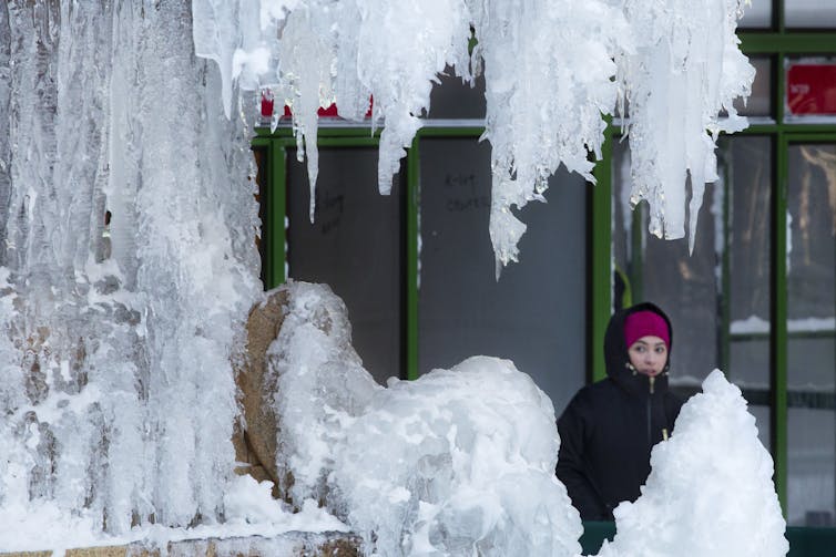
Seriously cold: The ‘bomb cyclone’ freezes a fountain in New York City.
AP Photo/Mark Lennihan
Jennifer FrancisRutgers University

Arctic News,
3 February, 2018


Damage from extreme weather events during 2017 racked up the biggest-ever bills for the U.S. Most of these events involved conditions that align intuitively with global warming: heat records, drought, wildfires, coastal flooding, hurricane damage and heavy rainfall. 
Paradoxical, though, are possible ties between climate change and the recent spate of frigid weeks in eastern North America. A very new and “hot topic” in climate change research is the notion that rapid warming and wholesale melting of the Arctic may be playing a role in causing persistent cold spells. 
It doesn’t take a stretch of the imagination to suppose that losing half the Arctic sea-ice cover in only 30 years might be wreaking havoc with the weather, but exactly how is not yet clear. As a research atmospheric scientist, I study how warming in the Arctic is affecting temperature regions around the world. Can we say changes to the Arctic driven by global warming have had a role in the freakish winter weather North America has experienced?
A ‘dipole’ of abnormal temperatures
Weird and destructive weather was in the news almost constantly during 2017, and 2018 seems to be following the same script. Most U.S. Easterners shivered their way through the end of 2017 into the New Year, while Westerners longed for rain to dampen parched soils and extinguish wildfires. Blizzards have plagued the Eastern Seaboard – notably the “bomb cyclone” storm on Jan. 4, 2018 – while California’s Sierra Nevada stand nearly bare of snow.
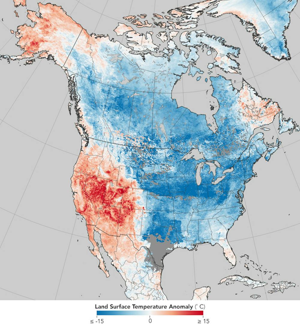
A study in contrasts: Warming near Alaska and the Pacific Ocean are ‘ingredients’ to a weather pattern where cold air from the Arctic plunges deep into North America.

NASA Earth ObservatoryCC BYThis story is becoming a familiar one, as similar conditions have played out in four of the past five winters. Some politicians in Washington D.C., including President Trump, have used the unusual cold to question global warming. But if they looked at the big picture, they’d see that eastern cold spells are a relative fluke in the Northern Hemisphere as a whole and that most areas are warmer than normal. 
A warm, dry western North America occurring in combination with a cold, snowy east is not unusual, but the prevalence and persistence of this pattern in recent years have piqued the interests of climate researchers. 
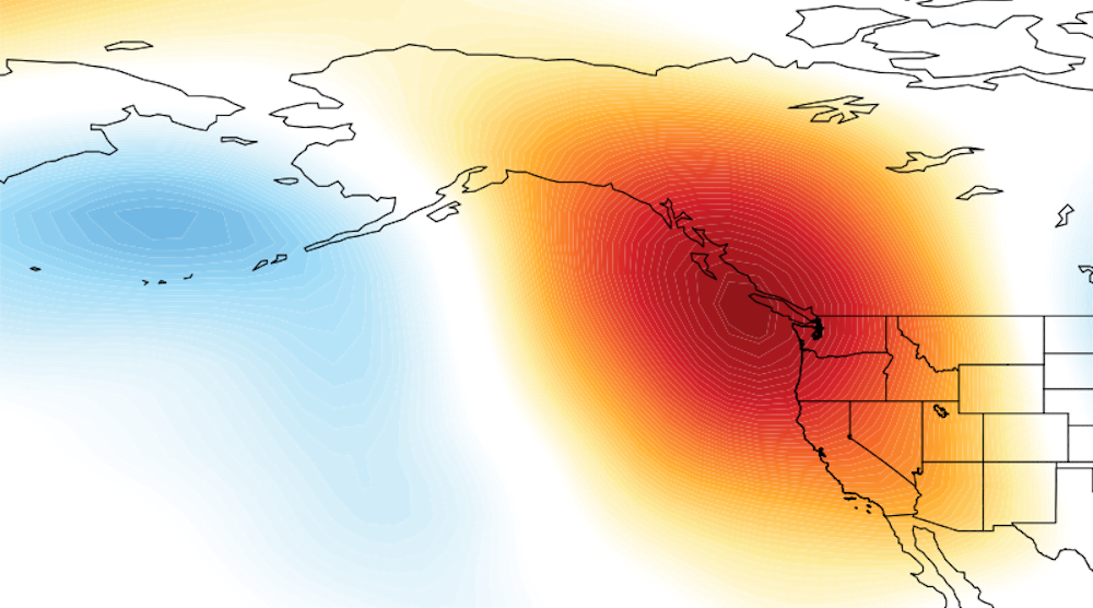
The jet stream – a fast, upper-level river of wind that encircles the Northern Hemisphere – plays a critical role. When the jet stream swoops far north and south in a big wave, extreme conditions can result. During the past few weeks, a big swing northward, forming what’s called a “ridge” of persistent atmospheric pressure, persisted off the West Coast along with a deep southward dip, or a “trough,” over the East. 
New terms have been coined to describe these stubborn features: The North American Winter Temperature Dipole,” the Ridiculously Resilient Ridge” over the West, and the Terribly Tenacious Trough” in the East.

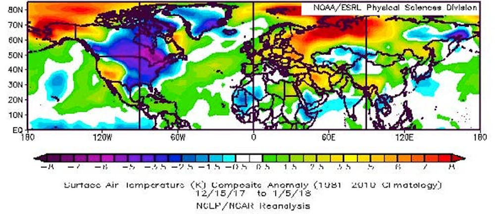
While the eastern U.S. suffered very cold temperatures in the recent cold snap, much of the rest of the Northern Hemisphere saw higher-than-average air temperatures.

Regardless what it’s called, this dipole pattern – abnormally high temperatures over much of the West along with chilly conditions in the East – has dominated North American weather in four of the past five winters. January 2017 was a stark exception, when a strong El Niño flipped the ridge-trough pattern, dumping record-breaking rain and snowpack on California while the east enjoyed a mild month.
Two other important features are conspicuous in the dipole temperature pattern: extremely warm temperatures in the Arctic near Alaska and warm ocean temperatures in the eastern Pacific. Several new studies point to these “ingredients” as key to the recent years with a persistent dipole.
It takes two to tango
What role does warming – specifically the warming ocean and air temperatures in the Arctic – play in this warm-West/cool-East weather pattern? The explanation goes like this. 
Pacific Ocean temperatures fluctuate naturally owing to short-lived phenomena such as El Niño/La Niña and longer, decades-length patterns. Scientists have long recognized that those variations affect weather patterns across North America and beyond.

When a persistent area of atmospheric pressure stays in the western U.S., air from the Arctic pours into the U.S, causing a split between the warm and dry West and the cold East.

The new twist in this story is that the Arctic has been warming at at least double the pace of the rest of the globe, meaning that the difference in temperature between the Arctic and areas farther south has been shrinking. This matters because the north/south temperature difference is one of the main drivers of the jet stream. The jet stream creates the high- and low-pressure systems that dictate our blue skies and storminess while also steering them. Anything that affects the jet stream will also affect our weather.
When ocean temperatures off the West Coast of North America are warmer than normal, as they have been most of the time since winter 2013, the jet stream tends to form a ridge of high pressure along the West Coast, causing storms to be diverted away from California and leaving much of the West high and dry. 
If these warm ocean temperatures occur in combination with abnormally warm conditions near Alaska, the extra heat from the Arctic can intensify the ridge, causing it to reach farther northward, become more persistent, and pump even more heat into the region near Alaska. And in recent years, Alaska has experienced periods of record warm temperatures, owing in part to reduced sea ice.
My colleagues and I have called this combination of natural and climate change-related effects “It Takes Two to Tango,” a concept that may help explain the Ridiculously Resilient Ridge observed frequently since 2013. Several new studies support this human-caused boost of a natural pattern, though controversy still exists regarding the mechanisms linking rapid Arctic warming with weather patterns farther south in the mid-latitudes.
More extreme weather ahead?
In response to the strengthened western ridge of atmospheric pressure, the winds of the jet stream usually also form a deeper, stronger trough downstream. Deep troughs act like an open refrigerator door, allowing frigid Arctic air to plunge southward, bringing misery to areas ill-prepared to handle it. Snowstorms in Texas, ice storms in Georgia and chilly snowbirds in Florida can all be blamed on the Terribly Tenacious Trough of December 2017 and January 2018.

Cold weather from the Arctic combined with warm tropical air fueled a storm that produced well over a foot of snow and spots of flooding in Boston.

AP Photo/Michael Dwyer

Adding icing on the cake is the tendency for so-called “nor’easters,” such as the “bomb cyclone” that struck on Jan. 4, to form along the East Coast when the trough’s southwest winds align along the Atlantic Seaboard. The resulting intense contrast in temperature between the cold land and Gulf Stream-warmed ocean provides the fuel for these ferocious storms.
The big question is whether climate change will make dipole patterns – along with their attendant tendencies to produce extreme weather – more common in the future. The answer is yes and no. 
It is widely expected that global warming will produce fewer low-temperature records, a tendency already observed. But it may also be true that cold spells will become more persistent as dipole patterns intensify, a tendency that also seems to be occurring.
It’s hard to nail down whether this weather pattern – overall warmer winters in North America but longer cold snaps – will persist. Understanding the mechanisms behind these complex interactions between natural influences and human-caused changes is challenging.

The Conversation
Nevertheless, research is moving forward rapidly as creative new metrics are developed. Our best tools for looking into the future are sophisticated computer programs, but they, too, struggle to simulate these complicated behaviors of the climate system. Given the importance of predicting extreme weather and its impacts on many aspects of our lives, researchers must continue to unravel connections between climate change and weather to help us prepare for the likely ongoing tantrums by Mother Nature.
Jennifer Francis, Research Professor, Rutgers University