Showing posts with label global wartming. Show all posts

Sunday, 29 January 2017

More Arctic Ocean feedbacks

Arctic Ocean Feedbacks


27 January, 2017


The world's oceans are warming rapidly, and especially the Arctic. In December 2016, the temperature anomaly from latitude 83°N to the North Pole was 8 times as high as the global anomaly. The Arctic Ocean is warming particularly rapidly due to a multitude of feedbacks, some of which are illustrated on the image below.


As the Arctic is warming more rapidly than the rest of the world, the temperature difference between the Arctic and the northern latitudes decreases, which makes the jet stream wavier. Jennifer Francis has 
written extensively about jet stream changes as a result of rapid warming in the Arctic. In the video below, Peter Sinclair interviews Jennifer Francis on these changes.


The changes to the jet stream make it easier for warm air from the south to enter the Arctic and for cold air to move out of the Arctic deep down into North America and Eurasia. At the same time, this also increases the temperature difference between the continents and the oceans, which is quite significant given the rapid warming of oceans across the globe. The result of the greater temperature difference between oceans and continents is that stronger winds are now flowing over the oceans along the jet stream tracks.

Stronger winds come with more evaporation and rain, which accumulates as freshwater at the surface of the North Atlantic and the North Pacific. The freshwater acts as a seal, as a lid on the ocean, making that less heat gets transferred from underneath the freshwater lid to the atmosphere. This makes that more heat can travel underneath the sea surface through the North Atlantic and reach the Arctic Ocean.


The situation is illustrated by above image, showing areas over the North Atlantic and the North Pacific (blue) where the sea surface was colder than it was in 1981-2011 on January 27, 2017. Over these colder areas, winds are stronger due to the changes to the jet stream. At the same time, temperature anomalies as high as 18°C (or 32.4°F) are showing up off the coast of Japan, and anomalies as high as 10.9°C (or 19.5°F) are showing up near Svalbard in the Arctic.

The image on the right shows sea surface temperature anomalies from 1971-2000.

The 
video below shows precipitation over the Arctic, run on January 27, 2017, and valid up to February 4, 2017.


The changes to the jet stream and the associated changes discussed in this post all lead to further warming of the Arctic Ocean, next to the warming caused by other feedbacks such as loss of albedo and loss of ice as a heat buffer. Together, these feedbacks could cause global temperatures to rise by 1.6°C by 2026.

There are further feedbacks affecting the Arctic, as described at 
this page. Perhaps the most dangerous feedback is methane escaping from the seafloor of the Arctic Ocean. As the temperature of the Arctic Ocean keeps rising, it seems inevitable that more and more methane will rise from its seafloor and enter the atmosphere, at first strongly warming up the atmosphere over the Arctic Ocean itself - thus causing further methane eruptions - and eventually warming up the atmosphere across the globe.

Feedbacks and further elements of a potential temperature rise by 2026 of more than 10°C above prehistoric levels are further described at the 
extinction page.

The situation is dire and calls for comprehensive and effective action as described in the 
Climate Plan.


Links

• Climate Plan
http://arctic-news.blogspot.com/p/climateplan.html

• Feedbacks
http://arctic-news.blogspot.com/p/feedbacks.html

• Extinction
http://arctic-news.blogspot.com/p/extinction.html

• 2016 well above 1.5°C
http://arctic-news.blogspot.com/2017/01/2016-well-above-1.5c.html

• Accelerating Warming of the Arctic Ocean

http://arctic-news.blogspot.com/2016/12/accelerating-warming-of-the-arctic-ocean.html


Monday, 6 June 2016

Prof. Wadhams is predicting an ice-free Arctic this summer

Arctic could become ice-free 

for first time in more than

100,000 years, claims 

leading scientist

Professor Peter Wadhams of Cambridge University predicts we could see ‘an area of less than one million square kilometres for September of this year’


5 June, 2016
The Arctic is on track to be free of sea ice this year or next for the first time in more than 100,000 years, a leading scientist has claimed.
Provisional satellite data produced by the US National Snow & Ice Data Centre shows there were just over 11.1 million square kilometres of sea ice on 1 June this year, compared to the average for the last 30 years of nearly 12.7 million square kilometres.

This difference – more than 1.5 million square kilometres – is about the same size as about six United Kingdoms.
Professor Peter Wadhams, head of the Polar Ocean Physics Group at Cambridge University, told the Independent that the latest figures largely bore out a controversial prediction he made four years ago.

My prediction remains that the Arctic ice may well disappear, that is, have an area of less than one million square kilometres for September of this year,” he said.
Even if the ice doesn’t completely disappear, it is very likely that this will be a record low year. I’m convinced it will be less than 3.4 million square kilometres [the current record low].
I think there’s a reasonable chance it could get down to a million this year and if it doesn’t do it this year, it will do it next year.

Ice free means the central part of the Arctic and the North Pole is ice free.”

Most of the remaining ice within the Arctic Circle would be trapped among the myriad of islands along Canada’s north coast.
The last time the Arctic was clear of ice is believed to be about 100,000 to 120,000 years ago.
The rapid warming of the polar region has been linked with extreme weather events such as “bomb cyclones”, flooding in the UK and out-of-season tornadoes in the United States.
And the sea ice off the north coast of Russia, which normally insulates the water below to keep it cool, is no longer present for much of the year, allowing the sea to get significantly warmer than before.
Loss of Antarctic ice has soared by 75 per cent in just 10 years
Scientists have monitored greenhouse gas methane – once frozen on the sea bed – bubbling up to the surface at an alarming rate.
According to one study published in the journal Nature by Professor Wadhams and others, this could produce an average rise in global temperature of 0.6 degrees Celsius in just five years.
That would be a very, very serious upward jerk to global warming,” Professor Wadhams said, saying the prospect was “frightening”.
Less sea ice also means the surface of the Earth is darker, so it absorbs more of the sun’s energy.
Arctic warming: Rapidly increasing temperatures are 'possibly catastrophic' for planet, climate scientist warns
When the sea ice retreats, it changes the whole situation. People are right to be concerned about the sea ice retreat and disappearance mainly because of all these other feedbacks,” Professor Wadhams added.
Sea ice is usually at its lowest in September and starts to build again when the winter sets in.
Dr Peter Gleick, a leading climatologist, said he had “no idea” if Professor Wadhams’ prediction was correct.
And he added: “If it's wrong, this kind of projection leads to climate sceptics and deniers to criticize the entire community.”
However Dr Gleick said Professor Wadhams was right to sound a warning about the rising temperatures in the region, saying it was “extraordinarily disturbing even in a world of disturbing news about accelerating climate change”.
An ice-free - and even an ice-reduced - Arctic is leading to global impacts on weather and ecosystems, and most importantly, that the changes in the Arctic presage dramatic fundamental changes in climate throughout the globe,” he said.
We're on a runaway train, scientists are blowing the whistle, but politicians are still shovelling coal into the engine.”
Professor Jennifer Francis, of Rutgers University, says ‘We are definitely looking at a very unusual situation up in the Arctic’ (Wolfgang Kaehler/Getty)
Professor Jennifer Francis, of Rutgers University in the US, who has studied the effect of the Arctic on the weather in the rest of the northern hemisphere, was also sceptical about Professor Wadhams' prediction, saying it was “highly unlikely” to come true this year.
She said she thought this would not happen until sometime between 2030 and 2050.
But Professor Francis stressed: “We are definitely looking at a very unusual situation up in the Arctic.
The ice is very low and there have been record-breaking low amounts of ice in January, February, March, April and now May, so this is very worrisome.

Monday, 22 September 2014

Ocean warming in the Arctic

Bloom in the Bering Sea


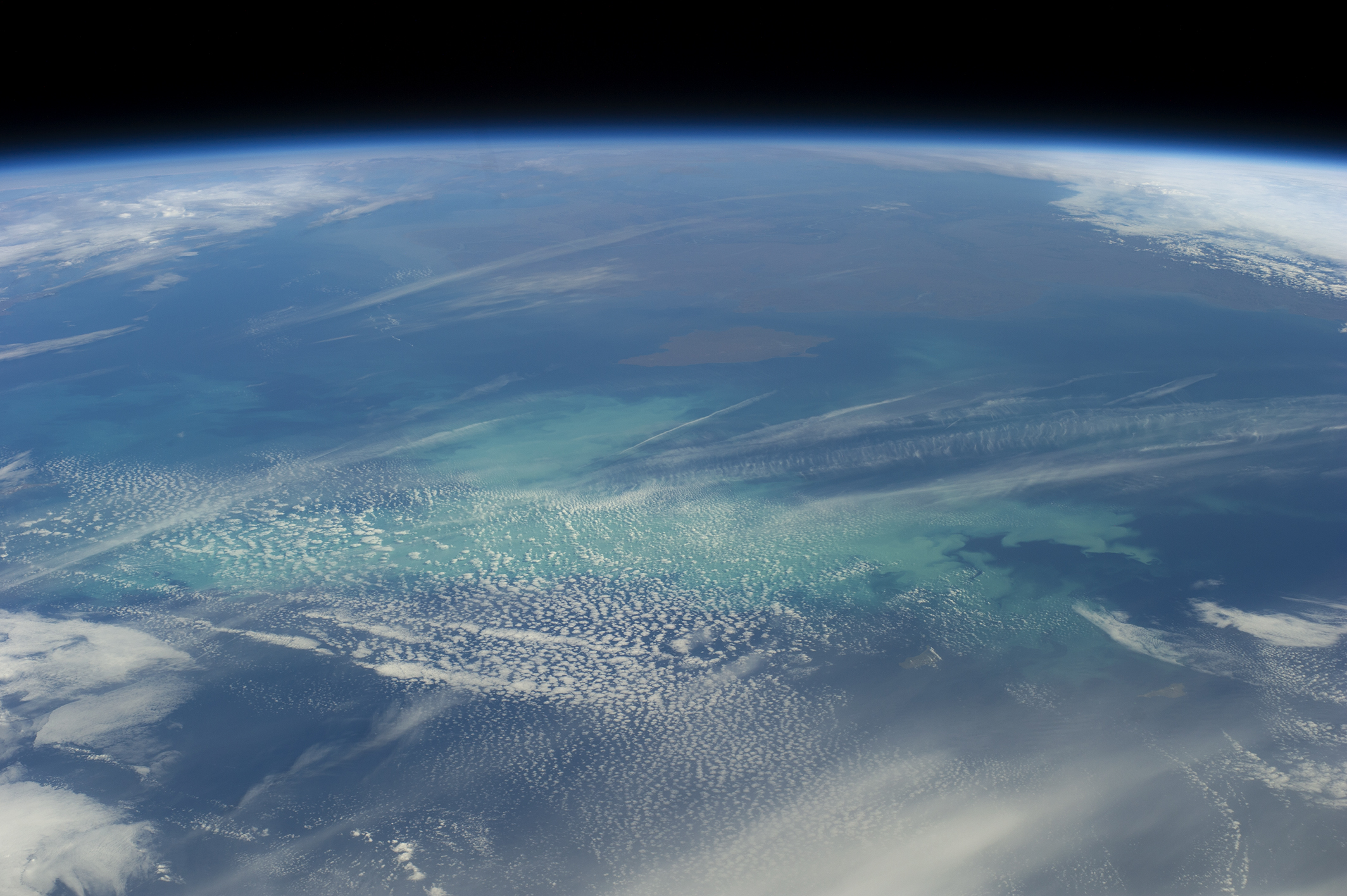
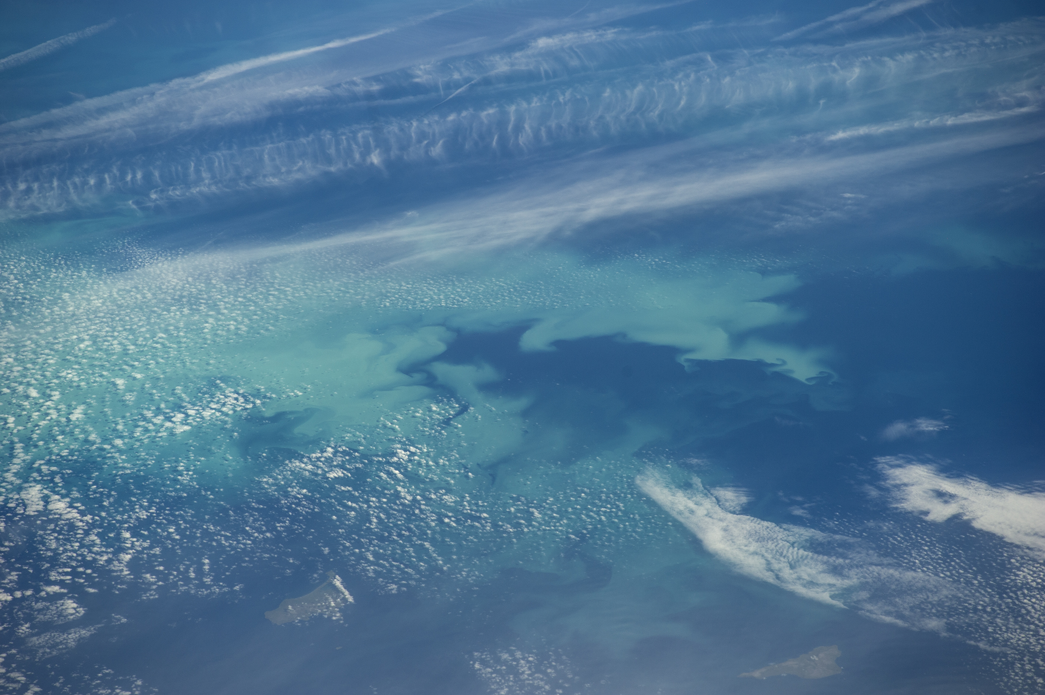
The Bering Sea is no stranger to phytoplankton blooms, such as this late-summer event off the coast of Alaska.

On September 4, 2014, the Moderate Resolution Imaging Spectroradiometer (MODIS) on NASA’s Aqua satellite acquired a natural-color image (top) of a bloom southwest of Nunivak Island and the coast of Alaska. The bloom was still visible a day later when astronauts aboard the International Space Station took photographs (below).

Blooms in the Bering Sea typically increase in spring, when nutrients and freshened water (from melting ice) are more abundant near the ocean surface. Then phytoplankton populations usually plummet in summertime after exhausting the nutrients in surface waters or falling prey to ocean grazers. By autumn, however, storms and cooler water allow nutrients to mix back to the surface, fueling more blooms.

acquired September 5, 2014
download large image (2 MB, JPEG, 2128x1416)

Phytoplankton blooms in the Bering Sea are very common,” said Kevin Arrigo, a biological oceanographer at Stanford University. “It is one of the most productive places in the world ’s oceans.”

The chlorophyll contained in these tiny plant-like organisms often shows up in natural-color images as a green hue. However, the phytoplankton in this image are very reflective, which suggests they are a type of algae called coccolithophores, according to Arrigo.

These algae cover themselves with little calcium carbonate discs, and if they are concentrated enough, they can make the water milky in appearance,” he said. “These kinds of blooms used to be rare in the Bering Sea but are becoming more common.”


acquired September 5, 2014
download large image (2 MB, JPEG, 2128x1416)

References and Related Reading

NASA Earth Observatory (2000, May 8) New Coccolithophore Bloom in Bering Sea.

NASA Earth Observatory (1999, April 26) What is a Coccolithophore?

NOAA Fisheries (2014, spring) Spring and Fall Phytoplankton Blooms in the Eastern Bering Sea During 1995-2011. Accessed September 12, 2014.


NASA MODIS image by Jeff Schmaltz, LANCE/EOSDIS Rapid Response. 

Astronaut photographs ISS040-E-12807 and ISS040-E-12808 were acquired on September 5, 2014, with a Nikon D3S digital camera, and are provided by the ISS Crew Earth Observations Facility and the Earth Science and Remote Sensing Unit, Johnson Space Center. The image was taken by the Expedition 40 crew. It has been cropped and enhanced to improve contrast, and lens artifacts have been removed. The International Space Station Program supports the laboratory as part of the ISS National Lab to help astronauts take pictures of Earth that will be of the greatest value to scientists and the public, and to make those images freely available on the Internet. Additional images taken by astronauts and cosmonauts can be viewed at the NASA/JSC Gateway to Astronaut Photography of Earth. Caption by Kathryn Hansen.