Showing posts with label flood. Show all posts

Friday, 27 July 2018

Deadly fires in Greece followed by devastating floods


Within 2 days we have gone from this...

To this


A flash flood has struck a northern Athens suburb following a squall, with the Greek capital's fire department receiving 140 calls for assistance and to pump water from flooded homes and businesses


A flash flood has struck a northern Athens suburb following a squall, with the Greek capital's fire department receiving 140 calls for assistance and to pump water from flooded homes and businesses.

Fire crews headed to an open-air parking lot in the suburb of Maroussi on Thursday to see if there were any people trapped in cars that were bobbing in a suddenly created muddy lake.

Authorities urged drivers to avoid the area and shut down a side road off the main highway leading north out of Athens.

The flash flood comes three days after a devastating wildfire northeast of Athens killed at least 82 people and injured more than 180.


Meanwhile, elsewhere


Israel hit by record-breaking heatwave; fires rage throughout country

Electricity usage breaks all-time record as soaring temperatures for July documented in several locations


A brushfire near Kibbutz Re'im east of the Gaza border, July 25, 2018. (Courtesy Fire and Rescue Services Southern District)
Firefighters battled a number of large blazes on Wednesday as Israelis sought to stay cool during an intense heatwave that set records for highest recorded temperatures in July.

Several large fires broke out in the afternoon at the Horshim Forest in central Israel and the Ahihud Forest in the north, as well as at the Churchill Forest near Nazareth Illit.


Seven firefighting crews and four firefighting planes were also working to put out a massive blaze near Kibbutz Re’im east of the Gaza border, one of 10 fires that broke out along the border since the morning.

Thursday, 11 January 2018

Major flooding on West Coast in New Zealand


Residents evacuated in Greymouth as flooding, rains hit

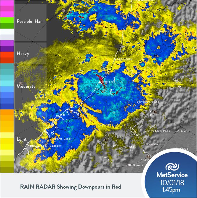
The heaviest rain expected for Greymouth could be bypassing the town and battering Hokitika and Ross instead.
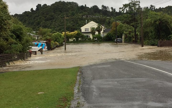
Surface flooding in Greymouth
Surface flooding in Greymouth Photo: Supplied / NZ Police
Radio NZ,
11 January, 2018

The area has already received 150 millimetres of rain overnight, forcing road closures, slips and surface flooding.
The Grey District earlier was preparing for more heavy rain to cause further flooding and slips this afternoon, with up to a dozen residents evacuated as a precaution.
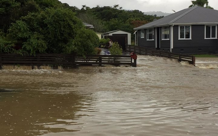
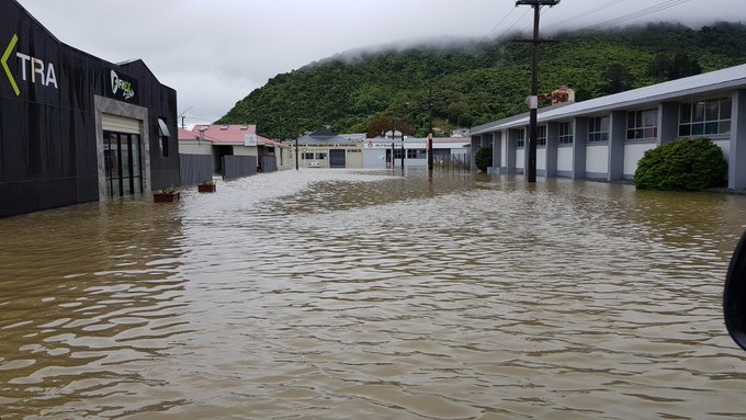
Heavy rain overnight and this morning caused slips, road closures and homes to be flooded in the district, as well as Greymouth's town centre to be inundated with water.
About 75mm of rain fell on Greymouth within two hours today, according to MetService.
Grey District mayor Tony Kokshoorn said while it was raining hard again, the forecast for the area was looking better.
"We are expecting a big part of this 100 millimetres that they are forecasting for tonight to bypass Greymouth and maybe hit further south in Hokitika and Ross
"So that will probably help us a little bit here, but we are still recovering from the 150 millimetres of rain that came down last night and this morning."
Mr Kokshoorn said he had spoken to residents who had their properties flooded and they were in good spirits.
He said the welfare centre that was set up at the Westland Recreation Centre in High Street had been closed because no one was using it, but it could be reopened if needed.
MetService warned the heavy rain was now moving on to Hokitika.
The district council earlier warned residents that if their property was at risk of flooding, they should move their belongings to higher ground.
While the central business district remained open, people were warned that driving through would cause floodwaters to surge into nearby properties, so they should only travel if absolutely necessary.
Surface flooding in Greymouth
Surface flooding in Greymouth Photo: Supplied / NZ Police
Mr Kokshoorn said up until last night there was a severe drought in the district.
"But it has broken with a vengeance at the moment," he said.
"So we've had some major flooding around the Grey District here, especially in Greymouth town itself."
Mr Kokshoorn said staff and the council met to ensure they were prepared for the rain this afternoon.
A Transport Agency spokesperson said the rain was particularly heavy around the Greymouth area and State Highway 67 - Westport and north to Granity and Ngākawau.
There was a slip at Omoto across one lane, with signs and speed restrictions in place.
The spokesperson said there was water and debris on State Highway 67 which was being monitored and dealt with as required.
There are also several small slips on Coast Road between Greymouth and Westport.
Meanwhile, floodwater pumps have been turned on in Christchurch, with the city also being hit with heavy rain today.
Council spokesperson Tim Joyce said some pumps in Flockton St, Ebbtide St and Maces Rd were now running, as was one in Main South Rd this morning.
He said the city could get up to 45 millimetres of rain today, but so far all of the pumps were coping.

Wednesday, 20 April 2016

Horses in the Houston floods

This gets pretty personal for me as I frequently contemplate our own horses and how the land may not sustain them in the future
Dramatic rescue of horse as historic floods hit Houston


Horses were seen struggling in high flood waters in Texas on Monday. Emergency responders have tried to reach several horses trapped near the Houston-area stable where flooding nearly reached the roofs of some buildings.


Friday, 31 July 2015

Glacial Outburst Foods and abrupt climate change

Glacial Outburst Flood — Human Hothouse Displaces Hundreds in Tajikistan


30 July, 2015


If you lived during the 1880s, when the globe was one degree Celsius cooler than it is now, you’d see far less in the way of heatwaves. But an immense vomiting of greenhouse gasses into our atmosphere and oceans by fossil fuel industry since that time has greatly multiplied these periods of extreme temperatures. So much so that you are now four times more likely to experience a heatwave anywhere on the globe at any given time than you were 135 years ago.

Heatwaves, depending on their intensity, can have serious consequences. The most direct impact is due to the excess heat itself. In the more extreme instances, heatwaves during recent years have featured an ominous capacity to hospitalize tens of thousands. These heat stroke victims, in the worst cases, perish. Such was the case for India and Pakistan this year where hundreds tragically lost their lives due to the impact of increased heat alone.

But if heatwaves occur in regions where glaciers still exist, the impact can be even more profound.
Glacier Outburst Flood In Tajikistan


(“The lake disappeared and turned to salt…” Melting of glaciers in Tajikistan is having a far-reaching impact. This UN-based program describes how the lives of Tajikistan’s people are being threatened by water loss due to glacier decline. But the impacts of glacier outburst floods can be more directly destructive.)
In Tajikistan, the heat is bringing with it a great decline in high elevation glaciers. Some have already disappeared. It’s a loss resulting in severe impacts to both energy and water security for the country. But perhaps even more disturbing is what happens when water is suddenly released from the dwindling glaciers.
Such was the case with Tajikistan this month. Beginning on July 16, an oppressive heatwave settled over this Central Asian nation. Temperatures rocketed to record levels. Baking its broad mountains — valleys, slopes and glaciers alike.
Crammed between Afghanistan, Pakistan, China, Kyrgyzstan and Uzbekistan, Tajikistan squats along the northwest boundary of the Tibetan Plateau. The upthrust of great glacier-capped peaks tower over this country. Peaks whose heads are loaded with a great volume of ice that is now being forced to rapidly melt.
This month’s record heatwave dealt a terrible blow to that ice. The glaciers, of which Tajikistan boasts 8,492, were already greatly weakened by a 3 degree Celsius temperature increase over the past five years. All it took was the shove of the most recent temperature surge to push some of these to the breaking point. By Tuesday, a great outburst flood had ripped through the mountain valleys of the Central Asia country. The outburst flood waters roared out, overtopping rivers — washing away more than 50 homes, cutting off major roadways, and driving 620 persons into government disaster shelters.
Unfortunately, this most recent climate change mass casualty event may be just one of many. In Tajikistan, a mud dam has developed along the path of major glacial melt. Water pressure is building behind the dam. Should it release, more than 30,000 people will be in the path of the outburst food.

Risk of Outburst Flooding Near Large Glaciers is a Global Hazard

All throughout the Tibetan Plateau region glacial outburst floods related to human-caused warming are on the rise (see the glacial megaflood). As much as 70 percent of the ice within the great Himalayan glaciers could melt out by 2100 under business as usual fossil fuel burning. The result would be a crescendo of glacial outburst floods followed by a period of drastically increased aridity for the lands around Tibet.

Alaska. Prince William Sound, waterfall flows from under Blackstone Glacier.

(The high elevation of glaciers combined with the vastness of their captured water and the often steep grades upon which they perch can generate violent flooding in the event of rapid melt. In many instances, silt from glacial outflows can develop a dam downstream of the glacial flood. Such dams are often unstable and can be subject to catastrophic collapse. In the worst cases, ice dams can form in the interior sections of very large ice sheets — such as those seen in Greenland and Antarctica. Glacial outburst floods due to such melt and ice dam formation in the major ice sheets are catastrophic events of geological scale and impact. Image source: ADT.)

Glacial outburst floods are sudden, powerful, violent, and difficult to predict. They are limited only by the amount of water the glaciers themselves release — ice masses that hold volumes of water often measured in cubic kilometers. The drastic impacts and terrible violence due to this kind of flooding was also recently witnessed during 2013 in Kedarnath, India. And what we see in Tajikistan and India during recent years is, sadly, just a taste of what’s to come in a fossil fuel emissions warmed world.

Finally, in this narrative, we cannot ignore potential glacial outburst flood impacts from melting over the Greenland Ice Sheet and Antarctica. And unlike Tibetan glacial melt, potential outburst flood events issuing from Greenland or Antarctica are a hazard of global scope. Such events would likely be driven by extended periods of rainfall over the ice during summer heating events. An ominous melt-driving phenomena that science is just now starting to track.

Links:
Hat Tip to TodaysGuestIs
Hat Tip to Colorado Bob

Flood Destroys Homes, Displaces Thousands in Central Asia


Sunday, 9 March 2014

Canterbury floods - before and after

Floods in Christchurch


powerful storm passed over New Zealand’s South Island in March 2014 and brought gale-force winds, torrential rains, and flooding to the city of Christchurch. A total of 74 millimeters (3 inches) of rain fell on March 4-5, according to MetService, New Zealand’s national meteorological service. More than 100 homes flooded and more than 4,000 lost power around the country’s third most populous city.

The surge of rainfall caused rivers—including the Waimakariri, Rakaia, Heathcote, and Avon—to swell with what appeared to be sediment-rich water. Skies had cleared enough by March 6, 2014, for the Moderate Resolution Imaging Spectroradiometer (MODIS) on NASA’s Aqua satellite to acquire this image showing the aftermath. While it’s not possible to make out patches of standing water in Christchurch, the large amount of suspended sediment flowing out from the rivers made dark blue coastal waters appear aquamarine. The lower image, acquired by MODIS on February 22, 2014, shows the same area before the storm.

When it comes to identifying a sediment resuspension event, the only way to be positive about the causes of the various colors in a satellite image like this is to have someone sample the water, but to go from dark to aquamarine over a few days over a large area with a strong storm passing in between is almost as good as being there with filters in hand,” noted Goddard Space Flight Center oceanographer Norman Kuring in an email.

Christchuch is located within a flood plain, occupying part of the large alluvial fan of the Waimakariri, thebraided-river just north of the city. Like other braided rivers, the course of the Waimakariri is dynamic. In the past, it has shifted as far south as Lake Ellesmere, but levees now constrain the Waimakariri along the northern edge of the fan.

Christchurch’s flood control infrastructure has been under increasing pressure in recent years because a series of earthquakes struck the area in 2010 and 2011. According to University of Canterbury researchers, the quakes caused land in some areas to drop, while narrowing and uplifting certain river channels. The result is an increased risk of flooding.

NASA image courtesy Jeff Schmaltz, LANCE/EOSDIS MODIS Rapid Response Team at NASA GSFC. Caption by Adam Voiland, with information from Norman Kuring.