Showing posts with label Timaru. Show all posts

Monday, 9 December 2019

Weather mayhem in New Zealand over the weekend

This report is abridged. See the original for full report

Recap: Weather mayhem leaves tourists stranded, major roads closed

The government announced this afternoon it may call in Air Force helicopters to evacuate some of the hundreds of tourists trapped in Franz Josef.
Mt Hercules slip
RNZ,
9 December, 2019

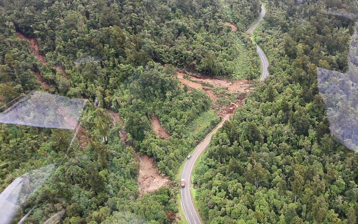
The highway from Hokitika to Franz Josef has been closed since Saturday after heavy rain over the weekend caused several washouts and slips along State Highway 6, and left hundreds of tourists and locals stranded in the region.
The road to the south of the town may not be open until Friday, and the road north is expected to take at least two weeks to clear.
It was hoped that by the end of today road crews would have a better idea of when the road south could be re-opened.
The township of Fox is also cut off, as are dairy farms in Whataroa, where they'll be having to start dumping milk today because no tankers have been able to get through since Friday.
A generator has helped restored power to Fox Glacier today where power had been out to some parts since Saturday.
About 1000 tourists and locals showed up to a town hall meeting at Franz Josef this morning at which the Civil Defence Minister, Peeni Henare, sought to reassure people.
He told them to register their names with Civil Defence if they did not have travel insurance, or had children or medical needs that meant they'd need help to get out of Franz before Friday.
Helicopter companies were flying people out but at a price ranging from a few hundred to a few thousand dollars.
Mr Henare said a free ride on an Air Force helicopter was something the government was willing to consider.
Bridge washout just after Mt Hercules heading south
Photo: RNZ / Conan Young
"Those are some of the support mechanisms that I know that we can put in place, which is why it's important to get a true picture of the need here. We know that insurance will cover for those who have insurance and for those that don't then that's when we really got to kick into gear and make sure we can support them the best way that we can."
Inflite Group, which operates scenic flights and skydive operations, has brought in extra aircraft from around the South Island to manage the demand for air tickets out of Franz Josef.
Spokesperson Dan Burt told RNZ the first people were flown out at 7.30am today, using aircraft relocated from Queenstown, Nelson and Aoraki/Mount Cook.
"We're taking a lot of people through to Mount Cook Village because we've got road transport operations available - we've got vehicles and buses available. Those people are going through to Queenstown while others are heading to Christchurch which has to be by air at this stage."
Mr Burt said passengers were being given a scenic flight as part of their ticket, and the company had offered to manage the return of rental vehicles left behind in Franz Josef.
In the meantime, extra food supplies such as bread, milk, and fresh fruit and veggies were being flown in this afternoon.

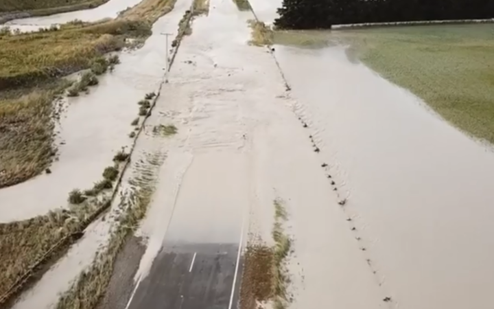
One bridge north of Timaru reopens

Timaru entered a state of emergency over the weekend, when torrential rain caused the Rangitata River to overflow and cut off access to the region. Subsequently, Rangitata Bridge on SH1 and the bridge at Arundel on SH72 had to be shut.
But the council said the reopened road would still be bumpy with some unsealed sections, and people who could postpone their journey should hold off until the main surge of held-up motorists was through.
Speed restrictions were in force and people were also advised to carry food and water for the trip because of the limited services enroute. Localised detours were also in place from Orari.
Rangitata River remains flood on Sunday 8 December, 2019.

On the West Coast, a number of power poles had come down along with the Chorus fibre attached. Once the electricity provider in the area restores its network then Chorus can restore its own network.
Chorus technicians plan to put a temporary fibre cable at Arundel so that broadband and phone services can be restored quicker, but assessment of another damaged fibre at the Rangitata Bridge on SH1 cannot be completed yet because of the flood.
Emergency accommodation for those evacuated is available at the Southern Trust Events Centre, 70 Morgans Road.
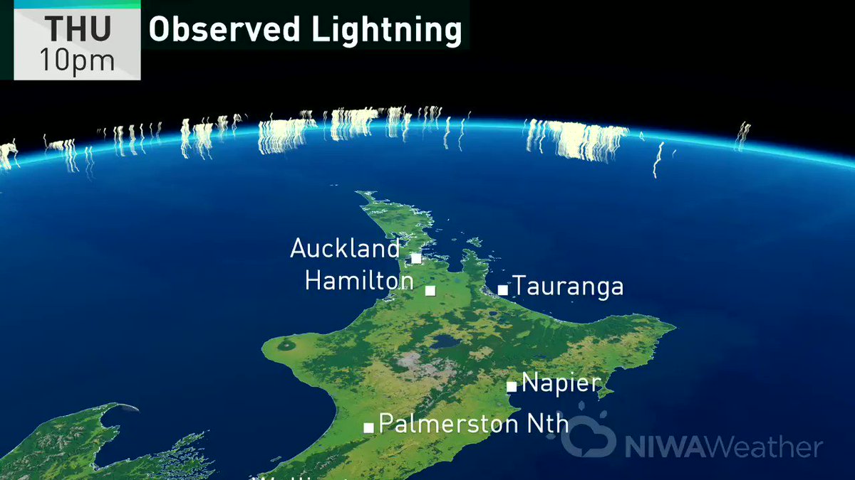
What to expect for the weather in coming days
MetService says a settled period of weather should allow the clean-up to get under way.
It said the front that brought the weekend's wild weather was now only having a few lingering effects on the East Cape of the North Island.
Meteorologist Andrew James said there was generally clear conditions ahead with a few showers but nothing like what had been seen in the last few days.
"We've got a good couple of days of weather down there for the clean-up operation."
NIWA meteorologist Chris Brandolino said well over a metre of rain had fallen in the West Coast in the past eight days.
"Even the lower elevations, Milford Sound [there's been] 608mm of rain ... they normally get 700 in the entire month of December. When you're getting 80 or 90 percent of your monthly rainfall in seven or eight days, that causes problems."
While skies are beginning to clear over Timaru today, more active weather and potentially with heavy rain could be expected again towards the end of the week and most likely the weekend.
However, James said the rain expected later this week would be nothing like the deluges that hammered both sides of the island in the last few days.

Saturday, 22 July 2017

Reflections on NZ's "weather bomb" and denial


A weather bomb hits New Zealand

Seemorerocks


Flooding at a service station in Timaru.

In the last 24 hours New Zealand has been hit by what can only be called a “weather bomb”, not for the first time this winter.

An indication of what hit New Zealand can be gained from the following weather map in which the whole country can be seen.


Also listening to a report on Radio NZ this morning it was reported that a rain gauge had indicated rain of 200 mm (8 inches) had fallen overnight whereas the average for the whole of July is 45 mm (1.8 inches).

A state of emergency has been declared for Dunedin and Timaru in the South Island and the army has been called in to help.


  • Dunedin, Timaru, Waitaki, Selwyn and the wider Otago region have all declared a state of 
  • emergency.
  • About 100 homes have been evacuated from Outram, a rural town west of Dunedin. Residents have been evacuated from Mosgiel and Henley.
  • The NZ Army has been called in to assist Civil Defence in Timaru and to take a sick Oamaru child to Dunedin.
  • South Cantabrians living near flood-prone areas have been urged to prepare for evacuation.
  • Homeowners have decided to leave some properties in North Otago after rising floodwaters submerged streets and bridges.
  • Wastewater was overflowing into some streets in Dunedin.
  • Civil Defence were preparing to evacuate some parts of Mosgiel if required.
  • Access to Milton, south of Dunedin, has been closed with State Highway 1 blocked north and south of the town.
  • Homes in Ashburton and eastern Christchurch were flooded on Friday morning.
  • Drivers were trapped in their cars in floodwaters near Rakaia in Canterbury.
  • Power is out in following roads in Dunedin: Old Brighton Road, Green Island Bush Road, St Leonards Drive, Berwick, Henley, Anzac Ave
  • Dunedin is expected to get the most rain - up to 200mm over a 27-hour period. Parts of Canterbury could receive up to 180mm of rain before noon Saturday.
  • The flooding has closed roads throughout Canterbury and Otago, including State Highway 1. The only highway connecting Canterbury and Otago is SH8 between Twizel and Omarama, but chains are essential.
  • SH7 Lewis Pass has reopened.
  • Up-to-date road conditions - full list.
  • The storm in pictures.
  • How to prepare for a storm.
Send your weather pics and videos to: newstips@stuff.co.nz
UPDATED JUL 22, 2017 10:48 AM


You’d think that people would be getting the idea that this is linked with, not just climate change but climate change happening “faster than previously expected”.

Instead Ms. Kim Hill said “this is not just weather – it’s a weather event, isn’t it?”

Wow, Kim, that’s radical, isn’t it?

It's possible to say anything when you just look at what is happening on your doorstep and you are unaware (or purposefully ignore) the evidence of what is happening on a global scale.

Typical of reactions is from a friend who was supposed to visit but put off his visit on account of the weather forecast despite my saying that the rain wasn’t that bad.

It turns out that Wellington was one of the few places in the country that was spared.

Rather than just be grateful my friend is saying “you can’t trust the weather forecasters”

What I can forgive in my friends I can't in public figures such as RNZ broadcaster who, in theory at least, are paid to bring us the NEWS, not pull the wool over our eyes.

****

I spend quite a lot of my time observing the weather in my locality and looking for patterns.  One thing I have observed in the last few years is a drought that never quite goes away in winter, despite periods of wet weather, illustrated by the fact that one of our friends living on the land had to get a water truck in, not in the middle of a summer drought but in the first half of winter.

There is no doubt that this has been a extraordinarily cold winter in New Zealand (certainly in comparison with previous years).

What I have noticed, above all, is that it has not been so much cold as damp. Here in Wellington we have not seen the sun for many days on end. It is as if we have a constant and complete covering of thick cloud that obliterates the sun.

Most importantly the winds that we are usually buffeted with (from the north and from the south alternately) have been missing and frequently there simply isn't any air movement in "Windy Welly".

Take this, from NZ Metservice:

DEVELOPING NEWS 9:20AM – SYSTEM ‘STALLS’ OVER PARTS OF CANTERBURY.
Our major winter storm will continue to cause challenges and problems through the day, with heavy rain, gales and snow lowering to low levels. This is significant event & people should keep up to date, through radio, news and social media.

I have observed that frequently, instead of moving quickly across the country as has historically been the case, weather systems STALL, so that even after a major weather event the usual clear, sunny weather that is typical is absent.

Look at this forecast for Dunedin (the epicentre of the weather bomb) for the next week.   Not much let up here for the poor people of Dunedin!

No automatic alt text available.

Now look at the weather map in the lead-up to yesterday's rain (from 36 hours ago)....


And compare that with the situation as of an hour ago (after the weather event). 

No "calm-after the- storm" for New Zealand!


The present pattern (if there is one) is completely different from what I have experienced for the previous 60 years of my life.

I have never seen weather getting "stuck" like this at any time before this.

The reactions I get from people is either people going around with their eyes shut and thinking dualistically ("isn't it 'nice' weather today" or "isn't the weather horrible?"). 

A good proportion of society, aged 40 or less, have no idea what more-or-less stable weather is like.

The weather I experienced growing up in the 60's has more in common with the weather my father experienced growing up in the 20's than anything we have now.

When I point out my observations people's responses are like my friend who pointed out that there was a frost a couple of days ago - so somehow that made my observations invalid, despite the fact that this may have been the first or second frost in a winter that is theoretically half over.


That brings me back to denial.....

When I started to realise that climate change is happening "faster than previously expected" and that many positive feedbacks later we have passed numerous trigger points that weren't supposed to happen until 2100 so that, at the very least, human civilisation is doomed - or, if you have any understanding of conservation biology and habitat - we are headed for the precipice, not in 2100 but in short order.

I have always seen Nevil Shute's  On the Beach as being, not only about a nuclear holocaust but about denial and how people respond to their inevitable, short-term demise.

Onethebeach.jpg
In this piece, "Dr. Doom", scientist  Julian Osborn is telling a few home truths about background radiation when he encounters the inability of c Holmes, wife of an Australian naval officer to deal with the truth.

In the past I was also a party pooper by insisting  on telling the truth like the character in the film.  The responses have often been similar to those in this scene.


By the end of the film, when the radiation cloud reaches Melbourne and people are directly confronted by their near-term mortality Julian Osborn commits suicide with carbon monoxide poisoning after doing what he wanted to do most in his life - win a race with his racing car, while the chief denier, Mary, ends her life, and those of her children, with cyanide while Cmndr Towers and the crew of the submarine Sawfish decide to "go back home" - to a home that no longer exists, to families that are long dead.

Acceptance.


This has set me thinking about my own position now that the news on every front gets worse and worse and our demise (either as a species or as a civilisation - take your pick) it may in fact be better to just inform those "with little dust in their eyes" and not insist that we are all doomed (which I believe with every cell in my body).

To those people who say that because I don't have any "solutions" I'd better not tell the truth I have very little to say.

I also have zero respect.

All this brings back an interaction with Nigel, a Green Party wallah who tried to convince me there was "scientific proof" (his words, not mine - I kid you not), that to be successful a "message" had to be 80% "positive" - one of the most blatant justification for LYING.

People like Nigel, or the liars at Radio NZ and elsewhere, will always feel the lashing of my tongue while I have breath in my body.  They are responsible and don't have the privilege of being deluded.

As for the rest I am rapidly coming to the conclusion that it does little good to disturb the illusions of those who are incapable, or unwilling to see things as they are although, with my restricted lifestyle I am quickly running out of things to say to such people.

Like the characters in On the Beach they will come to a realisation - in the end.

In the meantime my main wish is that people live their lives fully.

Friday, 21 July 2017

State of Emergency in Timaru from flooding

State of Emergency declared in Timaru as rain lashes NZ causing widespread flooding


  • State of Emergency declared in Timaru as rain lashes NZ causing widespread flooding
  • Dunedin, Timaru and Ashburton bore the brunt of the storm but there's more on the way.
  • A state of emergency was declared in the Timaru District at 3pm and residents in flood-prone areas told to prepare for evacuation at short notice.
  • NZ Transport Agency is urging drivers to consider delaying journeys south of Christchurch or north of Dunedin because of flooding.
  • Snow is likely to low levels in areas from Canterbury to Southland tonight
Flooding on Evans St in Timaru
4.30pm: Emergency Management Otago has activated and is supporting Waitaki District and Dunedin City to deal with the impacts of heavy rainfall, flooding and strong winds.
Waitaki Civil Defence activated its own emergency operations centre at 3pm.
Group Controller Chris Hawker says at this stage Emergency Management Otago is monitoring and liaising with emergency services along the length of the Otago coast as well as the Otago Regional Council’s hazards team, who are monitoring river levels and modelling how they will react to rainfall. 
Flood water filled the petrol station forecourt.
"We are at a very early stage and we know from the forecast and modelling that there is a lot more rain to come over the next seven hours or so, particularly in Dunedin," Mr Hawker says.
He says many roads are affected by surface flooding, including the state highways along the coast and also inland. Further inland, snow is likely to become a factor as the temperatures drop overnight.
"While many people might have had travel plans this weekend, we would urge everyone to consider the conditions and think twice about hitting the roads tonight."
4.20pm: Timaru is under water.
River levels are expected to rise significantly over the next few hours. Any residents in flood-prone areas should prepare for evacuation at short notice. If you feel unsafe, evacuate immediately without waiting for notification.
Emergency services will be checking all at-risk areas and working to help evacuate any properties deemed at risk. All directions issued by emergency services personnel must be complied with.
Flooding north of Ashburton on the State Highway 1
A number of roads in low-lying areas are now closed and non-essential travel should be avoided.
For further information monitor the Timaru District Council website andFacebook page.
An Ashburton house is surrounded by floodwaters after heavy downpours.
Source: Nicole Richardson
3.50pm: Cross winds are affecting flights at Queenstown Airport. Check flight info here.
3.40pm: Timaru has had a month's rain in eight hours.
3.25pm: The NZ Transport Agency is urging drivers to consider delaying journeys south of Christchurch or north of Dunedin today. There's significant flooding on SH1 and local roads in South Canterbury and along SH1 Coastal Otago from Timaru to Dunedin.
3.20pm: Timaru District Council has told 1 NEWS a state of emergency has been declared in the district as of 3pm today.
Earlier this afternoon the Timaru Civil Defence Emergency operations centre advised all residents in flood prone areas to get everything they need together ready to evacuate their homes quickly.
EOC Controller Justin Bagust said that people in particularly flood prone areas should now be making preparations in case they have to evacuate at short notice.
“We would strongly advise people in these areas to get themselves prepared to leave as soon as they feel at risk, not to wait for any official notification," he said.
3.00pm: Heavy rain and wind is still buffeting Canterbury and Otago and surface flooding has been reported in some areas.
South Cantabrians are being warned to get ready to evacuate.
Significant surface flooding on the road between Christchurch to Ashburton this afternoon has NZTA asking motorists to delay travel if possible.
A number of roads in Christchurch and Banks Peninsula have been closed and Fire and Emergency southern says at least 25 properties have been affected by flooding in the region.
The worst affected have been in Ashburton, Rakaia and Rangiora.
In Otago, flooding has been reported at Kakanui and inland from Maheno.
2.20pm: MetService have released Road Snowfall Warnings for the far south.
2.15pm: MetService say thundery showers are set to continue through to this evening for the northern half of the North Island. 
2.06pm: The Cadbury Jaffa Race and Steepest Street party in Dunedin has been postponed due to the bad weather.
1.53pm: Rainfall totals in Canterbury: 84mm in Methven, 79mm in Geraldine, 73mm in Ashburton, 70mm in Darfield, and 68mm in Akaroa this morning, according to MetService. 
1.45pm: Emergency services and volunteers near Mokihinui, West Coast battled the winter storm to rescue an injured man from a difficult location this morning, Nelson, Marlborough, West Coast Police say.
Emergency services rescue of injured man on the West Coast.
Source: NZ Police
Emergency services rescue of injured man from remote West Coast location.
Source: NZ Police
1.40pm: MetService say there's been 471 lightning strikes over the upper North Island.
1.30pm: Transport Christchurch are urging Ashburton and Christchurch locals to delay travel as flooding is causing delays.
1.27pm: Hail isn't the only thing battering Auckland today, as thunder and lightning struck the region overnight.
1.21pm: For the latest road closures check the bottom of our live updates, and stay up-to-date here.
1.14pm NZTA say widespread flooding conditions are affecting highways across North and South Canterbury with heavy rain continuing. If you're driving in the region today make sure you slow down and take extra care they say,
Surface flooding is also affecting roads throughout Tasman, Marlborough, Kaikoura Coast.
1:08pm Timaru District Council is advising residents to make preparations to evacuate in places prone to flooding. "This is a quickly developing situation and people need to be ready to go. This means ensuring you have clothes and fuel, as well as things such as knowing where family pets are."
12:36pm Police are advising motorists in Mid and South Canterbury to drive with "extreme caution" due to flooding in Ashburton, Waitaki and Timaru and the high country. "Some roads in these areas many not be passable in 2WD vehicles."
12:20pm Christchurch City Council is urging resident to avoid contact with water from the Avon and Heathcote Rivers and from Lyttelton and Akaroa harbours due to a risk of pollution. The council says contact should be avoided with these waterways until two days after the rain has stopped. 
12:18pm Flood water is getting into the wastewater netrowk and causing overflows in areas across Christchurch and Banks Peninsula. 
11:55am Southern Fire crews have received multiple call outs to flooding. The worst affected areas are Ashburton, Methven, Timarau and Rakaia. A spokesperson for Southern Fire told 1 NEWS they're on stand-by waiting for the rest of the bad weather to come. They want to reiterate they don't carry sand bags due to receiving a number of calls from concerned residents who are wanting to get their hands on some. People are urged to contact their local council regarding sand bags.
Surface flooding in Otaio SH1, South of Timaru.
Source: 1 NEWS
11:42am Aucklanders have taken to social media to share photos and video of hail that has lashed the city this morning.
11:41am The Inland Route in to Kaikoura (Waiau to Peketa) is currently closed due to multiple slips and rockfalls.
11:37am Several roads have been affected by surface flooding in Marlborough. Taylor Pass Road south of Wither Road, New Renwick Road, Wairay Bar Road, SH 63 - West Coast Road, Inkerman Street and Marama Road are currently flooded. 
11:30am The Ashburton District Council has issued a precautionary boil water notice for residents on the Montalto water scheme due to high rainfall levels. "Monitoring equipment at the Montalto treatment plant has detected high turbidity - otherwise described as murkiness - in the water supply." The precautionary notice will remain in place until further information is released from the council. 

11:20am MetService has issued a road snowfall warning for Lewis Pass, Lindis Pass and Dunedin to Waitati Highway. 
11:15am The storm currently battering the country is beginning to cause traffic chaos with slips blocking roads, and it's only expected to get worse.
Strong wind warnings have been issued for Bay of Plenty, Rotorua and Gisborne, with northwesterly gales gusting up to 120km/h in exposed places until about midnight.

Already a large tree has fallen on SH2 in Matata, in the Whakatane district between Mimiha Road and Pikowai Road, blocking both lanes of traffic.
On the same state highway, but in the Bay of Plenty, closer to Herepuru Stream a pohutakawa tree and slip are blocking a section of the road

In the South Island a slip is blocking one lane of SH6 between Nelson and Havelock.
And another further along SH6 on the Whangamoa Saddle near Lud River Bridge is blocking part of the road. 
NZTA is advising drivers to take extra care.
In the capital Ngauranga station has been closed due to flooding, but Metlink Wellington say a shuttle bus is running instead.
Due to weather conditions in the Wellington region worsening Metlink also cancelled a ferry sailing from Days Bay.