
 Posts
Posts


Alaska’s Epic 2015 Burning is One Month Ahead of Previous Worst Year; Canada Conflagration Continues, Eastern Siberia Wildfires Light Off
15
July, 2015
From
Canada to Alaska to Siberia, an immense half-crescent of the Arctic
is on fire. The hot spots along this zone include freakish fires with
50 mile fronts, fires that generate thunderstorms from the heat of
their updrafts, and fires that paint smokescapes over the lake waters
of Canada even as they light the sky red:
(Freakish
lake fire burns in Saskatchewan, Canada on Monday, July 13. It’s
just one of thousands of fires now raging through Arctic lands and
5,105 fires burning through Canada alone.)
Fires,
overall, that have been vastly under-reported in the mainstream
media. And, even when they are reported, they include often
inaccurate qualifiers.
So
what the heck is really going on? The human hothouse is generating an
ever-greater burning potential throughout the Arctic. One that has
erupted toward new levels of intensity this year. One that is plainly
and painfully visible to any who care to look.
*
* * * *
In
Alaska,
a massive area the size of one and one half Connecticuts (7,300
square miles) has already been consumed by fires. A zone of
smoldering tundra, boreal forests turned to ash, smoking bogs, and
smoldering, thawing permafrost.
But
aside from a
handful of responsible sources (see
also here),
the mainstream media just can’t get what is now likely to be the
worst fire season ever to strike Alaska right. So let’s take a few
moments to set the record straight on what is an unprecedented
burning of Alaska’s warming tundra, forests and permafrost. A
burning that is related to human greenhouse gas emissions-based
heating of the atmosphere in that the thawing permafrost provides
additional understory and methane fuels to fires even as it
multiplies the number of fire-igniting lightning strikes.
A
Failure to Accurately Report on an Ongoing Disaster Directly Linked
to Humanity’s Greenhouse Gas Emissions
At
first, a sudden, abnormal outbreak of hundreds of wildfires
throughout the Arctic state during June was framed ‘not abnormal.’
That is until June shattered all previous records for worst wildfires
ever and put all notions that anything normal was going on soundly to
bed.
Next,
the narrative ran on the false meme that most of the fires were
caused by human hands (of the match tossing variety). Any journalist
worth their salt, however, could simply check that pseudo factoid
against the Alaska
Interagency Coordination Center report
to find that 377 fires were lightning-caused (well more than half)
and that these lightning-caused fires, as of Tuesday, amounted to a
whopping 4,675,000 acres burned. The human match, lighter, and
campfire ignited fires? A piddly 30,000 acres. In other words, more
than 99 percent of all the area burned was due to a
warming-intensified proliferation of thunderstorm activity and
related lightning strikes.
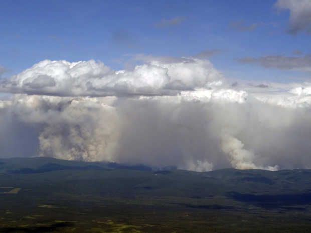
(Pyrocumulus
clouds have been popping up like hothouse amplifying daisies all over
Alaska since mid June. This ridge fire appears to be in the process
of building its own thunderstorm. Image source: ADN.)
Indirectly,
we could certainly call this extra lightning human-caused — as the
vehicle of greenhouse gas warming has resulted in a marked increase
in lightning strikes to the thawing permafrost and heating forest and
tundra fuels. But this particular human cause is certainly not of the
typical match-throwing, arsonist variety. It’s another story
entirely. A much more important story that far too many sources
appear to be (unintentionally or deliberately) missing. A story of
the plainly visible and worsening impacts of human-forced climate
change.
To
use any set of language other than to characterize the Alaska burning
as unprecedented, freakish, record, and abnormal is vastly
irresponsible. Any attempt to attribute the 4,675,000 acres ignited
by warming induced lightning strikes to ‘arson’ is equally myopic
and misleading. If you’re reading a source that makes these claims,
that source is an invalid and untrustworthy reporting medium. One
that can’t keep a handle on even the most basic of facts.
Alaska
Burning is One Month Ahead of the Worst Fire Year Ever
And
when all the dust of this mass misinformation over a critical issue
directly related to human-caused climate change settles, we
find that Alaska’s fires are now burning at a rate fully one month
ahead of the previous all time record fire year of 2004.
Tuesday’s total acres burned of 4,705,000 stood but 1,900,000 acres
shy of that record. And at the current rate of burning, that total
could be consumed within a mere 7-15 days — putting the current
Alaska wildfire season, by late July or early August, at new record
thresholds with more than a month left for forests, tundra and
permafrost to continue to burn.

(Hundreds
mile long smoke plumes issuing from Wildfires in Alaska on July 14.
Image source: LANCE-MODIS)
In
the July 14 MODIS satellite shot we can clearly see massive smoke
plumes billowing up from the still energetically burning fires in
Central Alaska. Lightning laden cumulonimbus clouds ride overhead —
a pattern refreshed by a continuous influx of warm storm moisture
rising up over the Gulf of Alaska and deflected off the ridiculously
resilient ridge (RRR) to the south. The storms are still setting off
around 3-7 fires each day. A rate of new ignition that, though slower
than June, is pushing total number of Alaska fires toward the
unprecedented 700 line.
7.5
Million Acres Burn in Canada
Across
the border in Canada a
whopping 5,105 fires are now also consuming vast stretches of Arctic
land.
It’s an outbreak that resulted in the
largest natural disaster evacuation in the history of Saskatchewan.
One that has drawn firefighters from all over the world to combat an
immense proliferation of blazes. Blazes
that have burned about 7.45 million acres so far or an area about the
size of 2.3 Connecticuts.
When
combined with the Alaska fires, the total area now burned in Arctic
sections of North America now equals about 12.1 million acres or more
than 1 million acres burned since this time last week. Rates of
burning for Canada are, like Alaska, in many cases unprecedented.
Total acres burned for the Arctic nation are now at two times the
five year average and three times the 25 year average. Specific
regions, like British Columbia, are seeing as much as 10 to 20 times
the typical area burned by mid July.
Vast
Wildfire Eruption in Eastern Siberia
Moving
on across the rapidly thinning ice of the Beaufort, Chukchi and East
Siberian seas,we
find that Eastern Siberia is also experiencing a massive wildfire
outbreak.
Reports from Russia on acres burned have tended to be spotty. But
this zone near Lake Baikal has seen a persistent and then an
expanding propagation of burn zones toward the north and east since
April.

Today,
the fire outbreak there could best be described as vast. Stretching
from Lake Baikal to the Sea of Okhotsk, the fire zone now encompasses
a region more than 1,000 miles across. Scores of large fires can be
seen burning beneath a massive cloud of smoke that streams all the
way down through China, combining with the nasty coal dust cloud
stooping over that fossil fuel victimized state.
One
cluster of these fires, visible in the upper left of the image frame
above and zoomed in below features fires with fronts in excess of 50
miles long. These are truly immense fires. Individual blazes large
enough to consume small states burning through the carbon rich boreal
forests and permafrost zones:

(Immense
fires with fronts as long as 50 miles from end to end ballooned in
Siberia today. Image source: LANCE-MODIS).
For
reference, the above image’s lower frame edge covers more than 250
miles. This gives us a sense of the utterly huge fires burning away
from lower right to center frame.
Conditions
in Context — Human-Caused Warming Vastly Increases Arctic Wildfire
Potential, Wildfires Make Climate Change Worse
The
massive outbreaks of fires in Canada, Alaska and Eastern Siberia
during 2015 are not occurring in a vacuum. They are not isolated
disasters to simply report, confuse, forget, and then report again
when the new record fires erupt in 2016, 2017, 2018 or 2019. They are
instead symptoms of a larger trend of polar amplification in the
Arctic.
There
more than 1,400 billion tons of carbon in the permafrost is now being
set to rapidly thaw. The permafrost, when unlocked from its
primordial, thousands to millions year old, ice traps yields this
carbon in solid, liquid, or gaseous form. The solid peats, the liquid
organic carbons, and the methane seeps all provide new and highly
volatile fuels for wildfires.
In
addition, boreal forests are not fire resilient like their more
southerly cousins. The trees there do not typically face flame or
intense ignition sources. So when an atmosphere heated by human
fossil fuel burning produces powerful, lightning flinging
thunderstorms in the Arctic for the first time in thousands to
millions of years, the trees there have no natural defense against
the fires that inevitably ignite. Individual trees may as well be
standing sticks of dynamite in the face of this warmth-driven
barrage.
Other
factors include tree killing pest invasions, the thin mat of
flammable material that underlies most Arctic forests, and the drying
tendency of the added heat itself.
So
much forest, tundra soil and permafrost burning in the Arctic can
eventually have its own sort of warming-amplifying effect. For the
fires, fires that are likely not even natural to the slower periods
of warming faced by Earth during past hothouse events, rapidly unlock
the carbon stored in the forests as well as the rapidly thawing
permafrost beneath. This
release adds to the already extremely intense carbon emission from
human beings and further heightens the danger of hitting climate
points of no return.
This
is the signal the media has lost in all its talk of ‘not abnormal’
and ‘arson.’ A warning cry from the Arctic. And one we had better
not ignore.
Links:
Hat
Tip to Andy in San Diego
Hat
Tip to Colorado Bob
Hat
Tip to Alexander AC
Hat
Tip to DT Lange


