Showing posts with label Ohio. Show all posts

Thursday, 8 March 2018

Massive methane disasgter in Ohio at Exxon Mobil site

Infrared Video Exposes Exxon Mobil Methane Disaster at Exploded Oil & Gas Site in Ohio
Experts are comparing the magnitude of the disaster to California’s Aliso Canyon


6 March, 2018

Captina Creek, Ohio — Today, Earthworks released new optical gas imaging video that exposes massive methane pollution at an exploded XTO oil and gas site in Belmont County, Ohio. The pollution has been rapidly spilling into the air un-contained since February 15, 2018.


Similar to the Aliso Canyon disaster in California in 2015, XTO has been unable to fix the problem,” said Pete Dronkers, Earthworks certified optical gas imaging thermographer who also filmed Aliso Canyon. “Our video provides evidence of just how bad the problem is so that nearby communities can make informed decisions about the health and safety of their families before returning to their homes.”

The video was captured as part of Earthworks’ Community Empowerment Project (CEP) as a result of a request from local community members who could see the explosion from their home two miles away. CEP helps protect communities and the climate by making visible normally invisible air pollution from oil and gas production, pressuring regulators and companies to reduce that pollution. In the past four years, CEP has documented and made publicly available over 500 incidents of oil and gas related air pollution in 16 states, Mexico and Canada.

Following the explosion at the Schnegg pad, Exxon Mobil-owned XTO ordered an evacuation for 30 homes within a mile of the site. The outer half-mile has since been approved to return, but some have elected to stay clear until the well pad is capped.

Disasters like this are difficult to predict and to regulate. If we really want to keep our communities safe we need to keep oil and gas in the ground,” said Jennifer Krill, Earthworks’ Executive Director.

U.S. Environmental Protection Agency report estimates pollution from the still out-of-control site at 100 million cubic feet per day. This pollution includes methane, produced water, brine, unknown condensate components, and volatile organic compounds — all being released into the surrounding environment untreated and unfiltered. California’s Air Resources Board estimates that the Aliso Canyon disaster in Porter Ranch, California in 2015 released an average of 49 million cubic feet of methane daily for more than three months. Methane is 86 times worse for the climate than carbon dioxide over 20 years according to the Intergovernmental Panel on Climate Change (IPCC).

Monday, 26 February 2018

Flooding in 8 Tri-state communities


Record Atmospheric Moisture Feeding Central U.S. Flooding
23 February, 2018
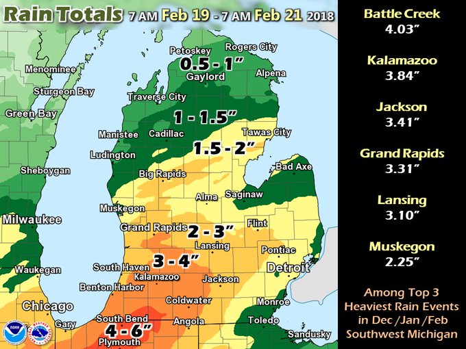
An unusually severe winter flood event is underway across the center of the U.S., from Texas to Michigan, thanks to heavy rains that fell during the week, fed by record to near-record atmospheric moisture for this time of year. The most significant flooding thus far has been in Southwest Michigan, Northwest Indiana, and Northeast Illinois, where the heavy rains fell on a snowpack that completely melted, releasing meltwater equivalent to another ½" – 1” of rain. In East Lansing, Michigan, floodwaters rose on the campus of Michigan State University from the Red Cedar River, causing some classes to be moved on Friday to non-flooded areas. Three drowning deaths have been blamed on the flood thus far, one death each in Michigan, Oklahoma, and Illinois


This was one of the greatest winter rainfall events on record in Southern Michigan (rivaling Feb 1997). Forecast river flooding may require actions to mitigate property loss. Every river point has a different history/vulnerability/forecast. http://www.weather.gov/grr/news20180220 
Precipitation forecast
Figure 1. Predicted precipitation for the 5-day period ending at 12Z (7 am EST) Wednesday, February 28, 2018. Monticello, AR has already had record February rainfall of 13.35” (previous record: 12.85” in 2001), and will add to that total. Memphis, TN has had 8.73” of precipitation from Feb 1 – 22; the forecast above calls for an additional 3” in February, which would beat their February precipitation record of 11.14", set in 1948. Image credit: National Weather Service.

Moderate to major flooding expected on the Ohio River

A relatively stationary front over the Ohio Valley will continue to be the focus of periods of heavy rain until late Sunday morning, when the front will finally push to the east. With soils saturated, these additional rains of 2 – 4” will exacerbate the moderate to major flooding already occurring along the Ohio River and its tributaries. Dry conditions on Monday and Tuesday will bring a welcome change to the wet pattern, before another significant rain-making storm moves in on Wednesday. Moderate to major flooding is predicted for the coming week along several hundred miles of the Ohio River, from Pennsylvania to the river’s confluence with the Mississippi River at Cairo, Illinois. The flood waters from the Ohio River will dump into the Lower Mississippi River by late next week; the forecast is for minor to moderate flooding on the Mississippi River by late next week.
Ohio River flood forecast
Figure 2. By Monday, the Ohio River along the West Virginia/Ohio border at Racine is predicted to reach major flood stage; the NWS advises that at the predicted water levels, the town of Racine, Ohio (population 650) will flood.  Image credit: NWS.

Record atmospheric moisture fed the flood

Accompanying the exceptional February warmth this week were record levels of February moisture, as a flow of unusually moist air rode northwards from the Gulf of Mexico, where water temperatures were about 1.0°C (1.8°F) above average. Meteorologists use a term called "precipitable water" to discuss how much water vapor is in the atmosphere. Precipitable water is defined as how much rain would fall on the ground if one took a vertical slice of the atmosphere above a given location and condensed all the water vapor into rain. Precipitable water levels tend to be higher when the temperature is warmer, since warm air holds more water vapor. This week, an extraordinarily large number of upper air balloon soundings set all-time records for February moisture. There are 73 radiosonde stations in the contiguous U.S. that take routine measurements twice per day, and six of them set all-time February precipitable water records this week; four of these stations broke their previous February record multiple times. That is a very rare occurrence, as radiosonde data goes back 70 years. Here are the new February precipitable water records set this week:

Detroit, MI, 3 new records: 1.38” at 0Z 21 Feb, 1.36” at 12Z 20 Feb, and 1.29” at 0Z 20 Feb; Old record: 1.15", 2/23/1985
Lincoln, IL, 2 new records: 1.47" at 12Z 2/20 and 1.36” at 0Z 2/20;  Old record: 1.34", 2/25/2001
Colombia, MO, 2 new records: 1.44" at 0Z 2/20 and 1.39” at 12Z 2/19;  Old record: 1.33", 2/21/1997
Shreveport, LA, 3 new records: 1.75" at 0Z 2/21, 1.69” at 12Z 2/21, and 1.75” at 0Z 2/23;  Old record: 1.66", 2/21/1974
Alpena, MI, 1 new record: 1.11” at 0Z 2/21; Old record: 1.09”, 2/12/1999
Davenport, IA, 1 new record: 1.18” at 12Z 2/21; Old record: 1.09”, 2/25/2001

Green Bay, WI (4th), Slidell, LA (6th) Nashville, TN (4th), and Jackson, MS (5th) all recorded top-ten February precipitable water values during one of their balloon soundings this week. Radiosonde data goes back to 1948.
Climate change's effect on extreme precipitation
Figure 3. Change in extreme precipitation by U.S. region. Left: change in the amount of precipitation falling in daily events that exceed the 99th percentile of all non-zero precipitation days, as calculated over 1958–2016. Right: the number of 2-day events with a precipitation total exceeding the largest 2-day amount that is expected to occur, on average, only once every 5 years, as calculated over 1958–2016. The numerical value is the percent change over the entire period 1958–2016. Image credit: U.S. National Climate Assessment and NOAA NCEI.

Global warming plays an important role in causing heavier downpours


An increase in heavy downpours (exceeding the 99th percentile) has been documented across every region of the contiguous U.S. since 1958 (Figure 3), and this increase has been partially attributed to the increase in atmospheric moisture due to human-caused global warming. Every degree Centigrade that the air warms up increases the amount of water vapor the air can hold by 7%, due to increased evaporation from the oceans. Thus, record-breaking atmospheric moisture and the resultant major flooding--like the situation observed over the central U.S. this week--are something we will see a lot more of as the climate continues to warm in coming decades. The average moisture content of the atmosphere has already increased by about 4% since the 1970s, as expected from theory (the Clausius–Clapeyron equation). This increase has been attributed, in part, to human-caused global warming. There is research showing that in the summer, we can expect to see an increase in hourly precipitation extremes (greater than the 99th percentile) of up to 14% per degree Centigrade of warming; at colder temperatures, the increase is about 7% per degree Centigrade of warming, as one would expect from the Clausius–Clapeyron equation. The authors argue that the "super Clausius-Clapeyron scaling" of 14% more hourly rainfall per degree Centigrade of warming in extreme events in summer happens because of the dynamics of convective (thunderstorm) clouds--the extra moisture causes more rainfall formation and more latent heat release when the water vapor condenses into liquid, which forces stronger updrafts, invigorating the thunderstorm, and potentially leading to a stronger rate of condensation and even more rainfall formation.

Here's what flooding looks like across 8 Tri-State communities


Saturday, 22 March 2014

Oil pipeline spill in Ohio


Interstate Pipeline Spills 10,000 Gallons of Crude Oil Into Ohio Nature Preserve

About 240 barrels of crude oil—roughly 10,000 gallons—leaked from a Sunoco pipeline this week, contaminating a large area in the Oak Glen Nature Preserve, near Cincinnati, OH.


19 March, 2014


Local, state and federal officials reported to the scene Monday evening and contained the leak by about 5 a.m. Tuesday, Cincinnati’s WCPO reported. The cause remains under investigation and cleanup could take two weeks.


Crude oil is pictured in a stream near the site of a pipeline leak in Southern Ohio. Photo credit: U.S. Environmental Protection Agency/via RT America

Sunoco Logistics Partners owns most of the Mid-Valley Pipeline Co. pipeline, which extends 1,000 miles from Michigan to Texas. No injuries were reported after the leak, according to the Cincinnati Enquirer.


U.S. Environmental Protection Agency (EPA) spokeswoman Heather Lauer said the crude oil was pooled in a marshland area about the size of a football field, as of Wednesday morning. There are natural barriers that the agency hopes will prevent it from seeping into the Great Miami River, which is just 150 meters away.


While some authorities say the leak is unlikely to affect drinking water in the area, the EPA is investigating and trying to ensure that the underground pipe’s oil has not leaked into the ground water supply. In addition to the Great Miami River, water treatment plants are nearby, upstream in Fairfield, OH and upstream on the Ohio River.


We do have a drinking well used for drinking on this side of the road that will be sampled in the near future, in addition, the health department has identified up to 70 more locations that will be looking into,” the EPA’s Steve Renninger told WCPO.

Crude oil flows from a stream to a lake near the oil spill. Photo credit: U.S. Environmental Protection Agency/via RT America


The first cleanup phase will take about a week or so, officials estimated. That includes recovering crude oil and contaminated land using powerful vacuum cleaners and large machinery.


[An oil spill] could definitely have been worse later in the spring when all of our wildlife is coming out of hibernation,” Bob Mason, stewardship manager with Great Parks, said. “Plus now the ground is still hard, still somewhat frozen, so that helps.”


The pipeline carries crude oil to refineries in Ohio and Oregon. Inspectors last checked it in 2011. A system-wide inspection of the 1,119-mile-long pipeline five years ago resulted in a $48,700 fine for Sunoco, which did not address corrosion problems in the pipeline.


According to the Enquirer, Gary M. Broughton placed the initial 911 call after taking in a “fuel, oily smell.” He got out of his car and saw oil spreading across a pond.


It’s absolutely terrible,” Broughton told the 911 dispatcher.


It made me sick when I saw it.”


Friday, 1 November 2013

Highest radiation alert in Cincinnati, Ohio

This information was rejected by Mike Ruppert brought to his attention dismissed  on the grounds that the only reference he could find to RADCON 5 were on beforeitsnews.com

On looking a bit closer it turns out this is the  system used by the Nuclear Emergency Tracking Center 

RADCOM 5 is their highest level of alert.

My conclusion is that this information should not be dismissed so easily.


Radiation Levels Spiking Across America! RADCON 5 Alert Near Cincinnati, Ohio


30 October, 2013


Conspiracy theory forums are now examining what appears to be radiation levels spiking across much of America with a thread titled Radiation readings skyrocketing across America. While another recent thread was called 28 Signs Pacific West Coast Fried with Radiation,much of these latest high  RADCON 2, 3 & 4 readings  appear to be centered upon middle America and parts of the East Coast as well, including a RADCON 5 Alert from one station in Kentucky. We’ve read that ‘Fukushima Death Plumes’ are now hitting Canada, have they arrived in America as well? Several videos below examine up-to-date Fukushima information and more below.


Radcon 5 Alert (30 October 2013) Cincinnati, Ohio (NETC)


October,30,2013 Nuclear Alert !!!


Fukushima: Send More Workers! Dispel RUMORS of Radiation! Update 10/29/13


FUKUSHIMA RADIATION HITTING USA CANADA MORE SO THEN JAPAN


To visit the Nuclear Emergency Tracking Center site GO HERE


From today 


Radcon 5 Alerts (31 October 2013) Minneapolis/St Paul (NETC) Howard, WI


Friday, 7 December 2012

Sinkholes in the United States


Here are a couple of articles that explore the phenomenon of the giant sinkholes in the United States - something that has been totally ignored by the media


Monster Sinkholes An Indication That Major Earth Changes Are Coming Along The New Madrid Fault?
Michael Snyder


3 December, 2012

The most powerful earthquakes in the history of the United States happened along the New Madrid Fault in 1811 and 1812.


Those earthquakes were reportedly felt more than 1,000 miles away.  Scientists assure us that one day we will once again see very powerful earthquakes along the New Madrid fault.

It is only a question of when it will happen. Today, the New Madrid fault zone covers portions of Illinois, Indiana, Missouri, Arkansas, Kentucky, Tennessee and Mississippi.


However, a major earthquake of magnitude-8.0 or greater would likely have a dramatic effect all the way from the Great Lakes all the way down to the Gulf of Mexico.


When most Americans speak of the “big one”, they think of what may happen along the coast of California someday, but the truth is that a New Madrid earthquake could potentially do far more damage.  So is there evidence that the New Madrid fault zone is waking up?  Yes, there is.


According to Bloomberg, there has been “a sixfold increase in the number of earthquakes that have shaken the central part of the U.S. from 2000 to 2011″.  Much of that increase is being blamed on human activity such as mining, drilling and fracking.


So could human activity aggravate the fault zone so much that it could set off a truly history-making earthquake at some point?  Well, the potential is certainly there.
That is why so many people are so concerned about the monster sinkholes that have appeared in the region in recent months.


For example, a massive sinkhole down in Louisiana is now over 8 acres in size and it has forced hundreds of people to flee from their homes.  You can see video of the Louisiana sinkhole right here.


Over in Ohio, a giant sinkhole has suddenly formed that is more than 30 feet deep and that is the size of four football fields.


That sinkhole caused part of State Route 516 to collapse and authorities say that it will likely be closed for many months.  You can see video of the gigantic sinkhole in Ohioright here.


Are these monster sinkholes an indication that major earth changes are coming along the New Madrid fault?  Has reckless human activity awoken a sleeping giant that we should never have messed with?


The sinkhole down in Louisiana is of particular concern because it has been venting natural gas.  A few days ago it reportedly “burped” which sounds kind of ominous.  Could we see some kind of an “explosion” at some point?
Many of those living in the area may not be able to return to their homes for quite a long time.  The following is from a recent Huffington Post article…

At the eight-acre, Bayou Corne sinkhole in Assumption Parish, owners of slab houses are waiting for methane-gas monitors to be installed in December.
The sinkhole deepened in November and coughed up debris and hydrcarbons late in the month. Cypress trees fell into the gap. Residents are watching natural gas being flared from the site and are ventilating homes while bayous around them bubble.


But if human activity is capable of producing sinkholes that are 8 acres in size and capable of causing a “sixfold increase” in the number of earthquakes in the middle part of the country, is human activity also capable of setting off the New Madrid fault?


Sadly, even most Americans that are living in that part of the country don’t really understand how incredibly massive and how potentially destructive this fault zone actually is.


The following is from a recent report from WREG in Memphis, Tennessee

Many people don’t realize that north Alabama lies in the impact zone of the New Madrid fault line, a sleeping giant that is approximately twenty times larger than California’s famed San Andreas fault. 
The biggest earthquake in U.S. history happened in the New Madrid seismic zone in 1812, and in just the last few weeks, activity along the fault line is starting to heat up. 


If the earthquakes that happened along the New Madrid fault zone in 1811 and 1812 happened today, the devastation would be unimaginable.


Back then, there were not that many people living in the area.  But even so, the destruction was incredible…

Accounts of the 1812 quake vary since there were no measuring instruments at the time, but most geologists say evidence shows it was at least a magnitude 8 earthquake, and possibly a 9 or higher.

The shaking was so intense that church bells started ringing as far away as Boston and New York.

Chimneys toppled from the Deep South to Canada, and President James Madison was awoken by the violent shaking as he slept in the White House.

Eyewitnesses said it even caused the Mississippi River to flow backwards for a time.


Unfortunately, there are now indications that the fault zone is becoming more active as a recent Examiner article explained…

Tuesday evening, two shallow earthquakes, although small, were felt in Mt. Carmel, Ill. as well as five miles outside Edmond, Okla. Illinois had the largest at 3.6 magnitude, leaving Oklahoma with a smaller 2.9 magnitude quake as reported by the USGS.

The fact that both of these quakes were shallow and follow on the heels of Kentucky’s 4.3 just 10 days ago makes the questions begin to fly. Is the New Madrid waking up? Is it gearing up for ‘the big one’? When Ky. Experienced a 4.3 two weeks ago, it was felt across 10-12 states. Although it didn’t knock runners off their feet, it did alarm many. Knoxville was among the cities that felt the quake.


The shaking was not minor in many areas, and it scared people as walls shook and many began to pray.


This is something that I have written about previously, and we all need to keep our eyes open for more reports about earthquakes in the middle part of the country.
When the “big one” does finally hit the New Madrid fault zone, it will be one of the biggest news stories ever.


We are talking about a catastrophe that would be so immense that it would be hard to imagine.  According to ABC News, a study by the Mid-America Earthquake Center found that in the event of a major earthquake along the New Madrid fault, “nearly 750,000 buildings would be damaged, 3,000 bridges would potentially collapse, 400,000 breaks and leaks to local pipelines and $300 billion in direct damage and $600 billion in indirect losses would occur.”


You can ready much more about the New Madrid fault right here.


All of this is even more frightening when you consider that there are 15 nuclear reactors along the New Madrid fault zone.


In the event that the “big one” strikes, we could be looking at Fukushima times 15.


We have been blessed to have avoided a major earthquake like that for so long in the middle part of the country, but there is no guarantee that the New Madrid fault zone will always be stable – especially considering how much it is being aggravated by man-made activity.


There are even some that believe that eventually we will see an earthquake of magnitude-9.0 or higher along the New Madrid fault.


Such an earthquake could literally change the face of the entire continent.  We are talking about an event that could potentially change the course of the Mississippi River and create bodies of water where none existed previously.


We seem to be moving into a time of increased seismic activity on the earth, and many scientists are convinced that the New Madrid Fault zone is definitely overdue for a major earthquake.


So will we see one in the coming years?


Media Silence on Mass

Sinkholes

By Anthony Gucciardi, NaturalSociety


26 April, 2012

Have you heard of the massive sinkholes popping up around the nation? Flammable craters spanning acres wide and leaking radiation, monster sinkholes described as 'apocalyptic' have forced residents out of homes, expelled radiation into the environment, and are now ushering in concerns about serious Earth changes in the near future. If you've heard of these sinkholes, chances are it has been from the alternative media.


It's a hot issue on forums, some social networking sectors, and certain alternative talk radio programs. Sure, it has come up in some mainstream reports here and there, but there are virtually no in-depth pieces tying everything together. And they often fail to mention the scale of these sinkholes, behemoth anomalies that can swallow up 100 foot trees, houses, with the latest Ohio sinkhole devouring 4 football fields of land. Events that are sending residents scrambling.


Fracking, Drilling, Mining Responsible for Sinkhole Changing Earth Events?

A more serious issue, even beyond the dangers posed by these radiation-leaking sinkholes, is how man-made processes like fracking and excessive drilling are changing the planet on a larger scale. Bloomberg reports that fracking is a likely cause for a dramatic rise (sixfold) in earthquake activity from 2000 to 2011. Not to mention contamination of the water and food supply.


Extreme mining practices by Texas Brine and others are also responsible for triggering the sinkholes.

So are these actions 'waking up' the New Madrid fault line? In case you're not familiar, the New Madrid fault line was responsible for the legendary 1811-1812 earthquakes dubbed the 'New Madrid' earthquakes. Extremely powerful and devastating earthquakes that are the most significant earthquakes to hit the United States in all of recorded history. As Investment Watch explains, the research indicating fracking and excessive mining in the expansion of earthquakes along the Madrid line reveals a concerning and plausible reality.


It is important to note that the New Madrid fault line includes areas within Illinois, Indiana, Missouri, Arkansas, Kentucky, Tennessee and Mississippi. In the event of a large (8.0 or higher) earthquake along the fault line, however, a much greater area would likely be affected.


Outside of the repercussions of the sinkholes, such as the radiation issue and major possibility of implosion or massive disruption in the area, what are the larger consequences of invasive fracking? Could a massive disaster be the result of greedy corporations endangering the entire nation? Furthermore, why is the mainstream media shying away from the issue completely?

Here is an interview with the author


Are Mass Sinkholes Caused by Fracking