Showing posts with label Mississipi River. Show all posts

Tuesday, 16 July 2019

Sunday, 14 July 2019

Hurricane Barry makes landfall


It really is only the alternative media who are reporting on the real context of this.The mainstream report the facts in a way to hide the true horror of this.


Hurricane Barry Moving 

Onto Louisiana Coast, All 

New Orleans Flights 

Canceled


Is the mainstream reporting on this?


Levee BREACHES & OVER-

TOPPING ! ! Near New 

Orleans -- Water Pouring-in!


13 July, 2019

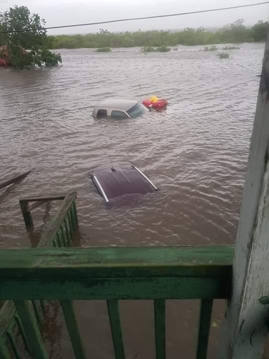
A levee has been BREACHED near New Orleans and water is POURING through as of 10:00 AM eastern US time, near New Orleans, LA, and Hurricane Barry has not yet even fully arrived!
The storm reached Hurricane strength this morning and is now a Category 1 Hurricane with maximum SUSTAINED winds of 74 MPH, and gusts to 87 MPH.
Also, at this hour, 63,000  customers are without electric power in Louisiana from the initial bands of the storm -- but the heart of the storm has not yet reached land.
Per the National Hurricane Center "Data from Air Force recon indicates that Barry has become the 1st hurricane of 2019 as it begins to make landfall in central Louisiana this AM."
UPDATE 10:25 AM EDT --
In addition to the breached levee shown above, reports are now coming in from Plaquemines Parish that levees there are being OVER-TOPPED by storm surge.
First responders are battling rising water that is overtopping a back levee system that protects some parts of Plaquemines Parish from coastal flooding.

Plaquemines Parish Homeland Security Director Patrick Harvey tells WWL-TV that crews started seeing overtopping along the back levee system that protects the Myrtle Grove and Pointe Celeste areas off Highway 23 around 5 a.m. 

The levees that are seeing overtopping are separate from the flood defenses that protect the parish from the Mississippi River.
More storm details HERE

UPDATE 10:40 AM EDT --
A levee in Myrtle Grove, which is in lower Plaquemines Parish, has been overtopped due to high water caused byTropical Storm Barry.

Lt. Gov. Billy Nungesser said Saturday morning that water is also flowing over the levees in Jefferson Lake and Point Celeste. Crews are working to contain the water. 

MORE:
The U.S. Coast Guard is mounting a rescue mission to save 12 people trapped in a coastal Louisiana community cut off by rising water from Tropical Storm Barry. (They had previously been told to evacuate but CHOSE not to leave.  Now, others must put THEIR OWN lives in danger to rescue these people. . .

UPDATE 11:00 AM EDT --
Barry is now officially a "Hurricane."  Here's the latest from the National Hurricane Center:

000
WTNT32 KNHC 131454
TCPAT2

BULLETIN
Hurricane Barry Advisory Number  13
NWS National Hurricane Center Miami FL       AL022019
1000 AM CDT Sat Jul 13 2019

...BARRY BECOMES A HURRICANE AS IT IS MOVING ONTO THE LOUISIANA
COAST...
...DANGEROUS STORM SURGE, HEAVY RAINS, AND WIND CONDITIONS
OCCURRING ACROSS THE NORTH-CENTRAL GULF COAST...


SUMMARY OF 1000 AM CDT...1500 UTC...INFORMATION
-----------------------------------------------
LOCATION...29.6N 92.0W
ABOUT 40 MI...65 KM S OF LAFAYETTE LOUISIANA
ABOUT 50 MI...80 KM W OF MORGAN CITY LOUISIANA
MAXIMUM SUSTAINED WINDS...75 MPH...120 KM/H
PRESENT MOVEMENT...NW OR 310 DEGREES AT 6 MPH...9 KM/H
MINIMUM CENTRAL PRESSURE...993 MB...29.33 INCHES


WATCHES AND WARNINGS
--------------------
CHANGES WITH THIS ADVISORY...

A Tropical Storm Warning has been issued for the Louisiana coast
from Cameron to Sabine Pass.

The Hurricane Watch for the Louisiana coast east of Grand Isle has
been discontinued.

The Tropical Storm Watch for the Mississippi coast has been
discontinued.

SUMMARY OF WATCHES AND WARNINGS IN EFFECT...

A Hurricane Warning is in effect for...
* Intracoastal City to Grand Isle

A Tropical Storm Warning is in effect for...
* Mouth of the Pearl River to Grand Isle
* Lake Pontchartrain and Lake Maurepas including metropolitan New
Orleans
* Intracoastal City to Sabine Pass

A Storm Surge Warning is in effect for...
* Intracoastal City to Biloxi
* Lake Pontchartrain

A Storm Surge Watch is in effect for...
* Biloxi to the Mississippi/Alabama border

A Hurricane Watch is in effect for...
* Intracoastal City to Cameron

A Hurricane Warning means that hurricane conditions are expected
somewhere within the warning area.  A warning is typically issued
36 hours before the anticipated first occurrence of
tropical-storm-force winds, conditions that make outside
preparations difficult or dangerous.  Preparations to protect life
and property should be rushed to completion.

A Tropical Storm Warning means that tropical storm conditions are
expected somewhere within the warning area within 36 hours.

A Storm Surge Warning means there is a danger of life-threatening
inundation from rising water moving inland from the coastline
during the next 36 hours in the indicated locations.  For a
depiction of areas at risk please see the National Weather
Service Storm Surge Watch/Warning Graphic available at
hurricanes.gov.  This is a life-threatening situation.  Persons
located within these areas should take all necessary actions to
protect life and property from rising water and the potential for
other dangerous conditions.  Promptly follow evacuation and other
instructions from local officials.

A Storm Surge Watch means there is a possibility of life-
threatening inundation from rising water moving inland from the
coastline in the indicated locations during the next 48 hours.

A Hurricane Watch means that hurricane conditions are possible
within the watch area.  A watch is typically issued 48 hours
before the anticipated first occurrence of tropical-storm-force
winds conditions that make outside preparations difficult or
dangerous.

For storm information specific to your area, including possible
inland watches and warnings, please monitor products issued by your
local National Weather Service forecast office.


DISCUSSION AND OUTLOOK
----------------------
At 1000 AM CDT (1500 UTC), the center of Hurricane Barry was located
near latitude 29.6 North, longitude 92.0 West. Barry is moving
toward the northwest near 6 mph (9 km/h), and a turn toward the
north-northwest is expected tonight, followed by a turn toward the
north on Sunday.  On the forecast track, the center of Barry will
move through southern Louisiana today, into central Louisiana
tonight, and into northern Louisiana on Sunday.

Maximum sustained winds are now near 75 mph (120 km/h) with higher
gusts.  As it moves inland, Barry is forecast to weaken below
hurricane strength in the next few hours, and it is forecast to
weaken to a tropical depression on Sunday.

Hurricane-force winds extend outward up to 45 miles (75 km) to
the east of the center and tropical-storm-force winds extend outward
up to 175 miles (280 km) from the center.  The National Ocean
Service station at Eugene Island, Louisiana recently reported
sustained winds of 62 mph and a wind gust of 82 mph.

The estimated minimum central pressure is 993 mb (29.33 inches).


HAZARDS AFFECTING LAND
----------------------
Key Messages for Barry can be found in the Tropical Cyclone
Discussion under AWIPS header MIATCDAT2 and WMO header WTNT42 KNHC.

STORM SURGE:  The combination of a dangerous storm surge and the
tide will cause normally dry areas near the coast to be flooded by
rising waters moving inland from the shoreline.  The water could
reach the following heights above ground somewhere in the indicated
areas if the peak surge occurs at the time of high tide...

Intracoastal City to Shell Beach...3 to 6 ft
Shell Beach to Biloxi MS...3 to 5 ft
Lake Pontchartrain...3 to 5 ft
Biloxi MS to the Mississippi/Alabama border...2 to 4 ft
Lake Maurepas...1 to 3 ft

Surge-related flooding depends on the relative timing of the surge
and the tidal cycle, and can vary greatly over short distances. For
information specific to your area, please see products issued by
your local National Weather Service forecast office.

RAINFALL:  Barry is expected to produce total rain accumulations of
10 to 20 inches over south-central and southeast Louisiana and
southwest Mississippi, with isolated maximum amounts of 25 inches.
Across the remainder of the Lower Mississippi Valley and western
portions of the Tennessee Valley, total rain accumulations of 4 to 8
inches are expected, with isolated maximum amounts of 12 inches.
This rainfall is expected to lead to dangerous, life threatening
flooding.

WIND:  Hurricane conditions are occurring over a small area east of
the center and should persist for a few more hours.  Hurricane
conditions are possible within the Hurricane Watch area today.
Tropical storm conditions are occurring across the Tropical Storm
Warning area to the east of the center at this time.  Wind gusts
to tropical-storm force in squalls are possible along portions of
the coasts of Mississippi, Alabama, and the western Florida
Panhandle through tonight.

TORNADOES:  A few tornadoes are possible through tonight across
the southeast Louisiana, southern Mississippi, and southern Alabama.


NEXT ADVISORY
-------------
Next intermediate advisory at 100 PM CDT.
Next complete advisory at 400 PM CDT.

$$
Forecaster Beven

UPDATE 11:18 AM EDT --
Levee broken in Montegut, LA. National guard present to make emergency evacuations.
 
The water came in so fast, they couldn't escape.

UPDATE 2:40 PM EDT --
Levee topped at bayou dularge in Terrebonne parish. Everyone South of Falgoust canal is now in a mandatory evacuation. They are going door to door.
 HWY 23 is flooding, if you don't get out now you won't.
Mandatory evacuation - Terrebone parish


People just reporting on the WEATHER are being subject to hacking

Sunday, 9 June 2019

The floods on the Mississipi snarl up transport


Punched in the Face’: U.S. Floods Snarl Trucks, Trains, Barges


8 June, 2019


Hundreds of barges are stalled on the Mississippi River, clogging the main circulatory system for a farm-belt economy battered by a relentless, record-setting string of snow, rainstorms and flooding.

Railways and highways have been closed as well, keeping needed supplies from farmers and others, and limiting the crops sent to market. For Chris Boerm, who manages transportation for Archer-Daniels-Midland Co., one of the nation’s largest agricultural commodities dealers, the weather is an unyielding, ever-changing challenge.

He and his co-workers spend time carefully planning out the quickest way to get supplies to the people that need them, he said. But it’s tough staying ahead of the drenching rain.

It’s sort of like Mike Tyson’s quote, everybody’s got a plan until you get punched in the face, right?” Boerm said by telephone. “Every day we come in and we’ve got a plan. But then it rains three inches somewhere overnight where it wasn’t expected, and the plan changes.”


That means supplies they plan to move on one river may need to be rerouted to a different waterway, or offloaded onto a rail car or a truck, with the hope they won’t be delayed by the weather as well. For instance, when water reaches the wheel bearings on a freight car in a siding, it can’t be hauled long distances without an inspection, yet another potential delay.

At just two locks along the upper Mississippi, almost 300 barges are being held in place as a result of high water and fast currents, according to Waterways Council Inc., which tracks barge movements. And hundreds more are waiting in St. Louis, Cairo, Illinois and Memphis, Tennessee, said Deb Calhoun, the council’s senior vice president.

It’s a big bottleneck,” Calhoun said.

The contiguous U.S. had its wettest January to May on records dating back to 1895, according to the U.S. National Centers for Environmental Information in Asheville, North Carolina. Nebraska, Kansas and Missouri had their rainiest May on record, the center’s data shows, while Arkansas, Oklahoma, South Dakota, Wisconsin and Illinois were all in the top 10.

Since last year, heavy snow fell on the Midwest and Great Plains, melting into saturated ground early in the spring. In March, a so-called bomb cyclone drenched Nebraska and Iowa with record rain and snow, sending the Missouri River out of its banks and creating a multi-state disaster area.


While high waters stop barge traffic, they also carry other dangers. Flood waters have closed off Interstate highways on a number of occasions and water itself. That overwhelms farm fields, sewer and septic systems and industrial plants along its banks, which can become quite toxic as it flows away from the river beds.

We dealt with a wet fall, and then record snowfall in many places,” said Tim Eagleton, senior engineering specialist for FM Global, an industrial insurer. “Of course, all that melts and comes down the Mississippi. Not only that, but we have had 200%-plus rainfall over a large part of that basin for months, and then a record-wet May in a lot of places.’

The bottom line, according to Eagleton: “Very long duration flooding on the Mississippi River that can really start to wear on people.’’ Almost 200 miles of the Mississippi has been shut down, he said.

Farmers are definitely feeling the crunch.

Iowa corn farmer Bob Hemesath, whose farm is about 35 miles west of the Mississippi River in Decorah, had planned to deliver about 20,000 bushels of corn to a Bunge Ltd. facility in McGregor in March and April. Instead, he ended up sending the grain to a local ethanol plant because the facility was closed due to high water levels and still remains shuttered.

He knows neighboring soybean farmers who are waiting to send their crops down the river as well. U.S. farmers still hold a lot of crops in their silos from their 2018 harvest because selling hasn’t made financial sense during the U.S.-China trade war, slow demand and slumping prices. Now, with northbound and southbound river traffic stalled, Hemesath is worried about what the barge backlog is going to look like this fall.

We are going to be missing almost three months of river traffic, I don’t even know how we will get caught up," he said. “If the river facilities don’t have barges that are caught up on old crop they won’t be able to ship new crop. It’s another stress for farmers.”

Among Boerm’s worries is that with the water levels so high -- and for so long -- there isn’t a lot of visibility yet on what the long-term impact to the waterways may be.

Boerm was an ADM manager in 1993, when more than 17 million acres were flooded across nine states in June through August. He recalls working with the Red Cross in Hardin, Illinois, sandbagging the bloated waterways and helping evacuate homes. The recent flooding is just as formidable a beast, he said.

In ’93, the flood was really kind of concentrated in Iowa and the Upper Midwest," Boerm said. "This has been much more expansive, getting all the inland rivers," affecting the entire Mississippi, the Arkansas River, the Illinois River and the Ohio River.

It’s impossible to know the full fallout until the waters recede, Boerm added.

That could take some time, according to Jeff Graschel, service coordination hydrologist with the Lower Mississippi River Forecast Center in Slidell, Louisiana. “A lot of locations since December to January have been above flood levels, and they probably will be in June to July,’’ he said. “We have another month or two before we can get some of these areas to go below flood.’’

Waterways near Baton Rouge, Louisiana, Natchez, Mississippi and Cairo, Illinois, have all set records for the length of the flood by weeks, Graschel said.

The repercussions will ripple through the economy for the rest of the year, said Jon Davis, chief meteorologist with RiskPulse, a weather analytics firm in Chicago. When crops that have been sowed late in the season to start moving to market, barge, truck and train traffic will soon be stretched thin, he said.

There are a couple of things that make this situation incredibly unique, the first of which is the longevity of the flooding, ’’ according to Davis. “The other factor is how widespread everything is.’’

Corn and soybean planting lags the five-year average, and grain shipments on the Mississippi, Arkansas and Ohio Rivers have already dropped well below last year and the three-year averages, according to the U.S. Department of Agriculture.


Tuesday, 28 May 2019

Oroville Dam update - 27 May, 2019


The people that defend the California Department of Water Resources (DWR) and say nothing is going to happen are like fetishists worshipping at the altar of an idol that is a piece of concrete.

This sort of infrastructure has a limited life (all the more so when there is corruption and neglect.

For these people experts like Bob Bea are like He-Who-Cannot- be named and totally ignored as with all the evidence on infrastructure in general and the state of the dam in particular.

One person even suggested that everything is as is should be because the rainy season ends at the beginning of May (sic). I wonder if they notice what is going on outside their window or have heard of climate change.

All the lakes in California are full to the brim and so the dam is going to overflow even if the spillway does hold up.

All the indications are that this is unlikely to be the case but we will know soon enough.

In the meantime there is something called the precautionary principle which is ignored every time by corrupt officials who would rather play poker with the affected public.

Whatever is built out of concrete is going to fail in the face of Mother Nature who can only be ignored at our peril for a certain length of time.

The trolls are all cretins.


An update on the Oroville Dam - 27 May, 2019


Oroville Dam Concrete is Spalling!!! Get Out Now!! May 27th 2019


Oroville Dam Watch Group Live Stream


Oroville Dam - May 26 2019 Update New! Please read! Important!


Update On Oroville and the Surrounding Lakes


Oroville Dam: New Info, Seismic Activity, Smoke Clouds, & Evidence - Juan Is Lying


LIVE: MAJOR OROVILLE DAM UPDATE and INTERVIEW with Paul Preston 5-27-19


NorCal Reservoirs Approach Capacity with More Rain and Snow in the Forecast


Butte County concerned over lake levels - DWR has no immediate plans for spillway releases


Record-breaking floods inundate parts of central US


America's Achilles' Heel: the Mississippi River's Old River Control Structure


Sunday, 26 May 2019

More evidence of threats to infrastructure in the face of widespread flooding

More evidence of infrastructure coming under strain because of the extreme flooding that is not going away


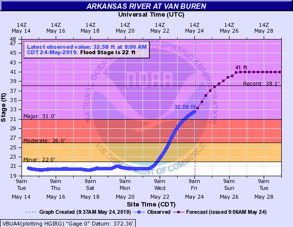
Biggest flood on record is coming this weekend to Fort Smith/Van Buren AR on the Arkansas River--projected to be nearly 3 feet above the previous record crest (Apr 16, 1945) water.weather.gov/ahps2/hydrogra…

Image

Record-breaking floods inundate parts of central US


Accuweather,
24 May, 2019


Evacuations are underway as flooding is impacting areas across Oklahoma, Kansas, Arkansas, Missouri, Illinois and parts of Nebraska and Iowa.

The U.S. Army Corps of Engineers is warning Arkansans about the possibility of historic flooding along the Arkansas River. Dardanelle, Arkansas, has been one of the more recent cities to face the floodwaters, the Arkansas River at this point reaching nearly 36 feet at 3 p.m. CDT on Saturday. Evacuations are also underway in Fort Smith, Arkansas. Gov. Asa Hutchinson declared a state of emergency on Friday.


Officials in Tulsa, Oklahoma are also urging some residents to prepare to evacuate and move to higher ground as the expected rain will threaten already stressed levees.

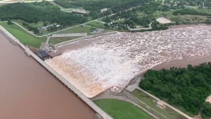
On Friday afternoon, water began flowed over the emergency spillway at Elk City Lake, reported in a tweet. Greenwood county authorities have called for the evacuation of residents who live below the Fall River Dam according to a local news source.

Three fatalities have been reported as a result of the flooding. One driver attempted to cross a flooded roadway in Perkins, Oklahoma, and two other bodies were found in a submerged vehicle near the Mississippi River in Missouri.

According to AccuWeather Meteorologist Kristina Pydynowski, there are rainfall estimates of over 8 inches in the last seven days across northeastern Oklahoma, southwestern Missouri and southeastern Kansas.

"So far this month, 10 inches of rain has soaked Tulsa, Oklahoma. The city averages nearly 6 inches for the entire month," Pydynowski said.

On Wednesday, two barges became loose during flooding on the Arkansas River. The town of Webbers Falls called for its 600 residents to evacuate.


"One can only guess what this Arkansas River flood crest would be like without the many flood-control dams and lakes upstream to hold back at least some runoff," Andrews said.

The Army Corps of Engineers continues to release 250,000 cubic feet of water per second from Keystone Dam into the Arkansas River and this level is expected to hold steady into Wednesday, May 29. Previously, the level was supposed to lessen on Sunday, May 26, but this changed Saturday morning as announced by Tulsa, Oklahoma Mayor G.T. Bynum.

Due to the additional release at Keystone Dam, flood water is steadily rising and residents and businesses along the Arkansas River need to heed all warnings and take precautions.


The excessive flow comes as water from flood control lakes in Oklahoma and Kansas is released into the Arkansas River.

"One can only guess what this Arkansas River flood crest would be like without the many flood-control dams and lakes upstream to hold back at least some runoff," Andrews said.

The Army Corps of Engineers continues to release 250,000 cubic feet of water per second from Keystone Dam into the Arkansas River and this level is expected to hold steady into Wednesday, May 29. Previously, the level was supposed to lessen on Sunday, May 26, but this changed Saturday morning as announced by Tulsa, Oklahoma Mayor G.T. Bynum.

Due to the additional release at Keystone Dam, flood water is steadily rising and residents and businesses along the Arkansas River need to heed all warnings and take precautions.
The flood gauge near Ponca City, Oklahoma, on the Arkansas River crested at 22.26 feet on Friday, breaking the 1993 record of 20.11 ft.

All residents should stay out of the water, adhere to traffic diversions, and maintain a close watch on children. The Tulsa Police Department has already had to remove people from the areas along the Arkansas River.

Bynum reminded parents not to let their children run around or play in floodwaters, as it could put both them and first responders at risk.


And this...

Mississippi Floodway May Be Opened for Third Time in History


A major barrier that keeps the Mississippi River in its current path may be opened for just the third time in its history, potentially flooding a large part of rural Louisiana.


Concern is growing that heavy rains will cause the Mississippi to flood over the top of the Morganza Floodway -- a long dam-like structure that is designed to divert 600,000 cubic feet per second of water to take pressure off the river. To prevent that, the Army Corps of Engineers may be forced to open the gates of the barrier.


The river has been high or flooding since last October, engorged by huge rainfalls that have slowed crop planting in the Great Plains and the upper Midwest. The Mississippi between New Orleans and Baton Rouge is lined with energy infrastructure including refineries, and the swell has caused shipping delays in the waterway, a main route for grain, chemicals, coal and oil.

There’s a risk that the river will flood over the Morganza by about June 5, which would render it useless, said Ricky Boyett, a spokesman for the Army Corps of Engineers. To avoid that, its 125 gates will have to start opening by June 2 at the latest, he said.

The decision to open Morganza Spillway has not been made yet,” said Jean Kelly, a spokeswoman for the Louisiana Department of Environmental Quality. The state’s governor, John Bel Edwards, is scheduled to hold a press conference this afternoon, according to local media.

This is just one more evacuation because of a dam.

Evacuations underway in parts of Greenwood Co. due to water release

KWCH,

24 May, 2019

GREENWOOD COUNTY, Kan. (KWCH) Evacuations are underway in parts of Greenwood County as record levels of water are being released out of Fall River Reservoir.


Greenwood County Emergency Management are urging residents to stay away from Fall River and the City of Fall River, south of the Fall River dam. They say the dam is releasing 36,000 cubic feet of water per second.

"Record levels of water are being released out of Fall River Reservoir that will cause widespread flooding, the Greenwood County Sheriff's Office said.

The county is currently conducting assessments and identifying significant damages that need emergency repairs. They are estimating it will take months to repair roads.

Officials say search and rescue operations are underway for people in the area. A shelter is set up in Eureka at Jefferson Street Baptist Church, 300 S. Jefferson Street.


America's Achilles' Heel: the Mississippi River's Old River Control Structure

May 10, 2019, 7:03 AM EDT

Above: Aerial view of the four structures of the Mississippi River Old River Control Structure, looking downstream to the south. Water flows from the Mississippi River through the four structures, to the Atchafalaya River (right). Image credit: U.S. Army Corps of Engineers.
10 May, 2019
America has an Achilles' heel. It lies on a quiet, unpopulated stretch of the Mississippi River in Louisiana, 45 miles upstream from Baton Rouge. Rising up from the flat, wooded west flood plain of the Mississippi River are four massive concrete and steel structures that would make a pharaoh envious: the U.S. Army Corps of Engineers’ greatest work, the two billion-dollar Old River Control Structure (ORCS). The ORCS saw its second highest flood on record in March 2019, and flood levels have risen again this week to their fifth highest level on record. While the structure is built to handle the unusual stress this year's floods have subjected it to, there is reason for concern for its long-term survival, since failure of the Old RIver Control Structure would be a catastrophe with global impact.

This first part of a 3-part series will study the history and importance of this critical structure, and how it almost failed in 1973. Part II, scheduled to run on Monday, is titled, Escalating Flood Heights Puts Mississippi River’s Old River Control Structure at Increasing Threat of Failure. Part III is titled, If the Old River Control Structure Fails: A Catastrophe With Global Impact, and will run later next week.
Mississippi River
Figure 1. Louisiana as seen by the MODIS instrument on March 21, 2019, showing the location of the Mississippi and Atchafalaya rivers, plus the Old River Control Structure, which diverts 30% of the flow of the Mississippi into the Atchafalaya. Floods of the two rivers were creating large sediment plumes in the Gulf of Mexico. Image credit NASA.

Chaining the Mississippi to its current channel

This marvel of modern civil engineering has, for fifty-five years, done what many thought impossible—impose man's will on the Mississippi River. Mark Twain, who captained a Mississippi river boat for many years, wrote in his book Life on the Mississippi, "ten thousand river commissions, with the mines of the world at their back, cannot tame that lawless stream, cannot curb it or define it, cannot say to it 'Go here,' or Go there, and make it obey; cannot save a shore which it has sentenced; cannot bar its path with an obstruction which it will not tear down, dance over, and laugh at." The great river wants to carve a new path to the Gulf of Mexico; only the Old River Control Structure keeps it at bay.

Failure of the Old River Control Structure and the resulting jump of the Mississippi to a new path to the Gulf would be a severe blow to America's economy, robbing New Orleans, Baton Rouge, and the critical industrial corridor between them of the fresh water needed to live and do business. Since a huge portion of our imports and exports ship along the Mississippi River, a closure would cost $295 million per day, said Gary LaGrange, executive director of the Port of New Orleans, during the great flood of 2011. An extended closure of the Lower Mississippi to shipping might cost tens of billions. Since barges on the Mississippi carry 60% of U.S. grain to market, a long closure of the river to barge traffic could cause a significant spike in global food prices, potentially resulting in political upheaval like the “Arab Spring” unrest in 2011, and the specter of famine in vulnerable food-insecure nations of the Third World.

Mississippi River
Figure 2. Two views of the Mississippi River. Left: the meander paths of the Mississippi over time, as published in "Geological Investigation of the Alluvial Valley of the Lower Mississippi River" (Harold N. Fisk, 1944, available online). Right: The Army Corps of Engineers' view of Mississippi River, with peak flow rates in cubic feet per second for a maximum 1-in-500-year "Project Flood”. The Corps has straightened the river’s path by cutting off meander bends, and has built multiple flood control structures capable of diverting a portion of the river's flow.

A shorter and steeper path to the Gulf

The mighty Mississippi River keeps on rollin' along its final 300 miles to the Gulf of Mexico south of New Orleans—but unwillingly. There is a more attractive way to the Gulf—150 miles shorter, and more than twice as steep. This path lies down the Atchafalaya River, which connects to the Mississippi at a point 45 miles north-northwest of Baton Rouge, 300 river miles from where the river empties into the Gulf of Mexico southeast of New Orleans.

Each year, the path down the Atchafalaya grows more inviting. As the massive amounts of sediment the Mississippi carries—scoured from fully 41% of the continental U.S. land area, plus a portion of southern Canada—reach the Gulf of Mexico, the river's path grows longer. This forces it to dump large amounts of sediment hundreds of miles upstream, in order to build its bed higher and maintain the flow rates needed to flush such huge amounts of sediment to the sea. Thus, the difference in elevation between the bed of the Mississippi and the Atchafalaya—currently about 17 - 19 feet at typical flow rates of the rivers—grows ever steeper, and the path to the Gulf down the Atchafalaya more appealing.

The two highest floods on record at the Old River Control Structure occurred in 2011 and 2019, and the 2018 flood ranked as the fourth highest on record. Floods like these further increase the slope, as flood waters scour out the bed of the Atchafalaya. Without the Old River Control Structure, the Mississippi River would have carved a new path to the Gulf in the 1970s, leaving Baton Rouge and New Orleans stranded on a salt water estuary, bereft of their main source of fresh water to supply their people and industry.

History of Old River

The Mississippi River has been carving a path to the ocean since time immemorial, always seeking the shortest and steepest route possible. Approximately once every 1000 years, the river jumps out of its banks and carves a new path to the sea. The Mississippi has been flowing along its current course past New Orleans since about 1000 A.D., but beginning in the 1800s, the Mississippi began slowly shifting more and more of its flow down the Atchafalaya River, along the path it used to take to the Gulf about 3000 years ago.

This diversion accelerated in 1831, when steamboat captain Henry Miller Shreve used his steam-powered snag boat Heliopolis to dredge a new channel for the Mississippi River. Shreve cut off a huge meander bend which shortened navigation of the Mississippi River by 18 miles and shifted the main channel 6 miles to the east. The two arms of the old severed meander created what is now called Old River, which connects the Mississippi to the Atchafalaya. The clearing of an ancient 40-mile-long log jam on the Atchafalaya in the 1840s, to allow navigation on the river for the first time, further increased the flow of water coming down the river from the Mississippi.
Einsteins
Figure 3. October 20, 1937: German-Swiss-US mathematical physicist Albert Einstein (1879 - 1955) (left) being greeted by his son Hans Albert on arrival at New York. In the 1950s, the younger Einstein helped with the design of the Old River Control Structure. Image credit: Keystone/Getty Images.

Building the Old River Control Structure


By the early 1950s, the Atchafalaya had captured over 20% of the Mississippi River’s flow, and the Army Corps of Engineers grew concerned that the Mississippi might change course as early as 1968. One of the experts that they called in to help study the problem was one of the world’s leading authorities on river sediment transport: UC-Berkeley hydraulic engineer Dr. Hans Albert Einstein, son of the famous Albert Einstein. With Hans Albert Einstein’s help, the Corps drew up the design for the Old River Control Structure, and construction began in the late 1950s. The structure resembled a dam with gates to control the amount of water escaping from the Mississippi to the Atchafalaya. This "Low Sill Structure", completed in 1963, consisted of a 566-foot-long dam with 11 gates, each 44 feet wide, that could be raised or lowered to control the amount of flow leaving the Mississippi. A companion "Overbank Structure" was built on dry land next to the Low Sill Structure, in order to control extreme water flows during major floods. The total cost of the two structures: about $560 million (2019 dollars).

Low Sill Structure
Figure 4. In 1987, after the newly-built Auxiliary Structure began operating, the Army Corps drained the channel to the Low Sill Structure and repaired some of the damages incurred in the 1973 flood. Above, we see the outflow side of the structure. The Low Sill Structure was designed to withstand a 37-foot difference in water levels (“head”) between the higher Mississippi River and the lower Atchafalaya River. Due to permanent damages to the structure during the 1973 flood, engineers determined that a safe differential in water surfaces on either side of the structure should be no more than 22 feet. Image credit: USACE.

The flood of 1973: Old River Control Structure almost fails

For the first ten years after completion of the Old River Control Structure, no major floods tested it, leading the Army Corps to declare, "We harnessed it, straightened it, regularized it, shackled it." But the structure underwent a severe battering during the flood of 1973, one that left it permanently damaged. During the fall and winter of 1972, exceptionally heavy rains fell throughout the Tennessee and Lower Mississippi Valley, saturating the soil and raising the level of the river. Then in early March, prodigious rains hit the watersheds of the Missouri and Upper Mississippi, and the Corps knew they might be facing a Project Flood—the maximum flood theoretically possible. The situation worsened in April, when an usually heavy snowpack in the Rockies melted suddenly, sending a massive pulse of flood waters down the Missouri and Arkansas rivers. When more heavy rains hit the Mississippi Valley in late March, the Mississippi River rose to dangerously high levels, forcing the opening of the Bonnet Carré Spillway for the first time in 23 years.

During this period, the Low Sill Structure was operated at more than 50 percent of a Project Flood flow—half a million cubic feet per second. The Army Corps began preparations to open the nearby Morganza Floodway to take pressure off of the Old River Control Structure, and promised to give five days of warning before opening the floodway. But as it turned out, it would have to be opened with very little warning.

Low Sill Structure
Figure 5. The Old River Control Structure’s Low Sill Structure as seen in April 1973. Turbulence from a major flood caused the 67-foot long southern wing wall on the intake channel leading to the Mississippi River to collapse on April 14, and a large eddy can be seen where the wall used to be. The eddy helped scour out a football field-sized hole up to 50 feet deep that undermined 7 of the structure’s 11 gates and nearly caused its failure. A ramp leading to the eddy was built, and an emergency stone replacement dike was built. Image credit: USACE.
James Barnett Jr.’s fantastically detailed 2017 book Beyond Control: The Mississippi River's New Channel to the Gulf of Mexico tells the story of how on April 14, 1973, the Old River Control Structure foreman walked out on the Low Sill Structure for an inspection, and witnessed the collapse of a 67-foot-long wall along the south side of the intake channel, facing the Mississippi. 

The six Niagara Falls' worth of water pouring through the channel pulverized the wall’s fragments and rammed them through the structure. A giant whirlpool replaced the missing wall and began attacking the structure, scouring away at the 90-foot deep steel pilings that supported it. The foreman reported that you could drive out onto the highway that crossed the structure, open your car door, and the vibration from the water hammering through the structure would close the door for you.

A camera was lowered down a hole drilled down through the center of the structure. The camera showed fish where there should have been solid earth. The river had begun scouring out a football field-sized hole over 50 feet deep underneath seven of the low sill's eleven gate bays. The scour hole came within 150 feet of a second, even-larger scour hole which had developed on the downstream side of the gates. Had the two scour holes merged, the entire structure would have been undermined and failed.

The head of the Army Corps’ flood fight efforts, Major General Charles C. Noble, gave the order to open the Morganza Floodway two days later to relieve pressure on the Low Sill Structure. The governor of Louisiana telephoned and asked if he had the authority to order that the Morganza Floodway not be opened. General Noble told him no. When complaints arose that he was not giving the promised five days' notice, he replied that the river didn't give him five days' notice.

The Corps brought in construction barges that continuously dumped boulders into the scour holes to keep Low Sill Structure from collapsing. In the end, the Low Sill Structure was saved but was permanently damaged, and can now only handle 60% of the flow it once could. So, the Corps was forced to build two new structures to stabilize the situation: the Auxiliary Structure (cost: $480 million 2019 dollars) and the Sidney A. Murray Junior Hydroelectric Plant, costing $1 billion (2019 dollars). We now have a much safer situation than in 1973—but as we will see in Part II, ever-higher flood crests are threatening to put an end to this reprieve.

Related works

There is a sequel to this


https://www.wunderground.com/cat6/If-Old-River-Control-Structure-Fails-Catastrophe-Global-Impact?cm_ven=cat6-widget&fbclid=IwAR3rvZ827lPNI6sabkQxMl2RWGeLe6VRv0lZtAfHI1T-gS2X-yGO1OlNShc

Finally, here is the latest report from Oroville