Showing posts with label Hurricane Jose. Show all posts

Friday, 22 September 2017

Cyclone Jose off the coast of NE United States

I haven’t heard anything of Jose for days

Jose Bringing Coastal Flooding, Rain, Wind to Parts of Northeast; Tropical Storm Warning for Southeast Massachusetts

21 September, 2017


Jose, now a post-tropical cyclone, will remain well off the East Coast of the United States but will still produce a combination of coastal flooding, high surf, tropical-storm-force winds and rainfall, particularly in far southeastern New England.


Tropical storm warnings continue for parts of coastal southeast Massachusetts, from Woods Hole to Sagamore Beach, including Cape Cod, Block Island, Martha's Vineyard and Nantucket.

Tropical-storm-force winds are expected in the warning area into Friday afternoon.


Tropical Storm Watches and Warnings
Jose's center is currently located about 145 miles southeast of Nantucket, Massachusetts, and is currently drifting westward.

Tropical-storm-force winds extend outward up to 205 miles from Jose's center, making it a large cyclone. Nantucket and Martha's Vineyard have been receiving winds gusts in excess of 50 mph throughout the day on Thursday, and these have continued into Thursday evening. Nantucket has reported wind gusts as high as 59 mph. 

Block Island, Rhode Island, reported sustained winds of 41 mph late Wednesday morning, and trees have been downed in numerous locations across eastern Massachusetts through Thursday evening. Five inches of rain has fallen on Nantucket through Thursday evening.


Jose Current Storm Info

Cool waters continue to put a damper on thunderstorm activity near Jose's center, and the core of Jose has cooled off. Thus, Jose is no longer a tropical system, but more of a winter-type storm. This actually allows for Jose to be more impactful along the Massachusetts coast because post-tropical systems usually have a large wind field and a large rain shield located well away from the center of Jose, in this case, located over southern New England. 


Jose Projected Path
The low-pressure center of Jose will then meander off the southeast coast of New England into this weekend.

However, Jose is close enough to the Northeast seaboard for some impacts into Friday.

Current Radar and Winds
Here's a look at the timing and what to expect from Jose.

Timing and Impacts

Jose is a large system resulting in far-reaching impacts. Through Friday, portions of coastal southeast New England may see bands of rain, possibly heavy at times.

Tropical-storm-force winds are most possible on Cape Cod, Block Island, Martha's Vineyard and Nantucket. Additional power outages and tree damage cannot be ruled out along the immediate coast within the tropical storm warning area through Thursday evening.

Thursday's Forecast
Jose is expected to produce additional rainfall amounts of 1 to 2 inches through Friday over Cape Cod and Martha's Vineyard. 

In addition, large swells from Jose will continue to affect the Eastern Seaboard and Bermuda during the next several days. This will contribute to life-threatening rip currents in some locations.

Minor coastal flooding is also likely through late week along southeast New England's shorelines with the potential for significant beach erosion, given the high astronomical tides and multiple tide cycles with coastal flooding.


Current Wave Heights


Sunday, 17 September 2017

Atlantic hurricane update - 09/16/2017

"Have we already arrived at the time of perpetual storms?"


--Kevin Hester

JOSE UPDATE/HURRICANE WATCHES/LEEWARD ISLANDS

BPEarthWatch

Dangerous TD 15 headed for Eastern Caribbean; Hurricane Jose Headed Towards New England

Dr. Jeff Masters ·


Above: MODIS view of Potential Tropical Cyclone 15 (later to become TD 15) on Saturday morning, September 16, 2017. Image credit: NASA.

September 16, 2017, 11:46 AM EDT


Tropical Depression Fifteen formed on Saturday afternoon in the waters east of the Lesser Antillies Islands, and tropical storm watches were hoisted for the islands of St. Lucia, Martinique, Guadeloupe, Barbados, St. Vincent and the Grenadines, and Dominica. TD 15 has the potential to be a hurricane by the time it passes through the Lesser Antilles Islands on Tuesday morning.

TD 15 had very favorable conditions for development on Saturday afternoon. Wind shear was light, 5 - 10 knots, SSTs were a very warm 29 – 29.5°C (84 - 85°F), and relative humidity at mid-levels of the atmosphere (as analyzed by the 12Z Saturday run of the SHIPS model) was moderately moist--about 60%. Satellite loops showed that TD 15 had a good deal of spin, and heavy thunderstorm activity was steadily increasing and growing more organized, with several curved low-level spiral bands forming. The first hurricane hunter aircraft is scheduled to investigate TD 15 on Sunday afternoon.

PTC 15 forecast
PTC 15 forecast
Figure 1. The 20 track forecasts for TD 15 (formerly Invest 96L) from the 0Z Saturday, September 16, 2017 GFS model ensemble forecast. Image credit: CFAN.
PTC 15 forecast
PTC 15 forecast
Figure 2. The 50 track forecasts for TD 15 (formerly Invest 96L) from the 0Z Saturday, September 16, 2017 European model ensemble forecast. The operational European model for TD 15 is the red line, adjusted by CFAN using a proprietary technique that accounts for storm movement since 0Z Saturday. The track of the average of the 50 members of the European model ensemble is the heavy black line. Image credit: CFAN.

Track forecast for TD 15


The model forecasts on Saturday morning were in better agreement than on Friday, predicting that TD 15 would be steered west-northwest at speeds ranging from 10 – 20 mph through Thursday, bringing the storm through the Lesser Antilles Islands on Tuesday morning, to the vicinity of the Virgin Islands and Puerto Rico by Wednesday morning, and near the Dominican Republic by Thursday morning. Beyond Thursday, the path of TD 15 will depend, in part, upon what Jose is up to. If Jose is still wandering off the U.S. New England coast, this will create a weakness in the ridge of high pressure steering TD 15 to the west-northwest, and TD 15 will turn more toward the northwest or north-northwest. If Jose is out of the picture, the ridge could keep TD 15 rolling west-northwestward. In either case, it is possible that TD 15 will approach the U.S. East Coast more than a week from now. A strong autumn-like upper-level trough will be moving across the western and central U.S. late in the week. This will tend to pump up a ridge toward the northeast U.S. and northwest Atlantic, which could end up blocking TD 15 from moving out to sea.

Intensity forecast for TD 15

The 12Z Saturday run of the SHIPS model predicted that TD 15 would have very favorable conditions for development over the next five days. Wind shear will be low, TD 15 will have very warm SSTs near 29.5°C (85°F), and there will be moist conditions at mid-levels of the atmosphere. These conditions should allow for strengthening of TD 15. On Saturday morning, our top intensity models—the HWRF, COAMPS-TC, DSHIPS, LGEM, and HMON—all predicted steady intensification of TD 15 into a hurricane by Tuesday, when the storm is expected to be moving through the Lesser Antilles. Further strengthening is likely through Thursday, until TD 15 potentially gets disrupted by passage over Puerto Rico and/or Hispaniola. Note that the official NHC forecast of a Category 1 hurricane on Tuesday and Wednesday is conservative; the 12Z Saturday runs of the HWRF and HMON models show TD 15 attaining Category 3 hurricane status by Tuesday afternoon. That may be too aggressive, but I would not be surprised to see TD 15 become a major hurricane by Wednesday, given how Hurricane Irma exploded into a major hurricane under similar conditions and in a similar location. The next name on the list of Atlantic storms is Maria.

Jose
Jose
Figure 3. GOES-16 view of Hurricane Jose at 11 am EDT September 16, 2017. Image credit: NOAA/RAMMB. GOES-16 data is considered preliminary and non-operational.

Hurricane Jose headed towards New England

Hurricane Jose was headed northwest at 9 mph towards North Carolina on Saturday morning, but is expected to turn to the north by Saturday night and pass several hundred miles east of the North Carolina coast on Monday. Jose's tropical storm-force winds cover a large area of ocean, extending out 150 miles to the northeast of the center. This wind field is expected to expand to 160 miles to the northeast of Jose’s center on Monday, then 230 miles on Tuesday. These winds are generating large swells that are bringing rough surf and the risk of rip currents to Bermuda, The Bahamas, the northern coasts of Hispaniola and Puerto Rico, and the U.S. east coast. Jose may bring up to 1” of rain to North Carolina’s Outer Banks on Monday, and heavier rains of 2 – 4” to Eastern Massachusetts beginning on Tuesday. The U.S. coast from Long Island, New York to Maine is at the edge of Jose’s 5-day cone of uncertainty.

Satellite images on Saturday morning showed that Jose had plenty of intense heavy thunderstorm activity that was well-organized, with a hint of an eye. The storm was less developed on its northwest side, where strong upper-level winds out of the west-northwest were tearing into the hurricane. An Air Force hurricane hunter aircraft will investigate Jose on Saturday afternoon.

Track forecast for Jose

A high-pressure system to the northeast of Jose will steer the storm mostly to the north over the remainder of the weekend, putting Jose a few hundred miles east of North Carolina’s Outer Banks on Monday. In their 11 am Saturday Wind Probability Forecast, NHC gave Cape Hatteras, North Carolina a 28% chance of seeing tropical storm-force winds from Jose. Jose is then expected to turn to the east-northeast and pass close to the coast of southeast Massachusetts on Wednesday. NHC gave Nantucket, Massachusetts a 50% chance of seeing tropical storm-force winds from Jose by Thursday morning. The large waves from the storm will be capable of causing high surf and considerable beach erosion along the shores of the mid-Atlantic and New England coasts during this period. Jose’s fate beyond Wednesday is coming into better focus, with the Saturday morning runs of the GFS and European models predicting that a trough of low pressure passing to Jose’s north continue to pull Jose to the east-northeast, out to sea. However, it is still possible that the trough of low pressure passing to Jose’s north will not be strong enough to do this, leaving Jose wandering in an area of weak steering currents a few hundred miles southeast of Massachusetts late in the week. This was the solution of the 0Z Saturday run of the UKMET model.

Jose forecast

Jose forecast
Figure 4. The 20 track forecasts for Jose from the 0Z Saturday, September 16, 2017 GFS model ensemble forecast. Jose is a potential landfall threat along the coast from Long Island, New York to Southeast Massachusetts, according to these forecasts. Image credit: CFAN.

Jose forecast

Jose forecast
Figure 5. The 0Z Saturday September 16, 2017, track forecast by the operational European model for Jose (red line, adjusted by CFAN using a proprietary technique that accounts for storm movement since 0Z Saturday), along with the track of the average of the 50 members of the European model ensemble (heavy black line), and the track forecasts from all 50 members of the ensemble. The European model ensembles show less of a threat to New England than the GFS model ensembles. Image credit: CFAN.

Intensity forecast for Jose

Jose was under high wind shear of 20 – 25 knots Saturday morning. But with sea surface temperatures (SSTs) near 29.5°C (85°F), Jose should be able to maintain hurricane status though Sunday morning. Higher wind shear of 30 – 35 knots is expected to affect Jose on Sunday and Monday, which should cause weakening, perhaps to a strong tropical storm with 70 mph winds, by Wednesday. Wind shear will likely fall to the moderate range again on Tuesday and Wednesday, but the waters beneath Jose will be steadily cooler as the storm heads north, discouraging any strengthening. SSTs are about 28°C (82°F) a few hundred miles off the coast of North Carolina, where Jose will be on Monday. Once Jose moves north of about 37°N (the latitude of Washington D.C.), the storm will be beyond the warm waters of the Gulf Stream, making it difficult for Jose to intensify. Water temperatures within about 400 miles of the coast, from New Jersey to Maine, are generally below 26°C (79°F). Most of the intensity models show Jose as a strong tropical storm with 60 – 70 mph winds throughout its closest approach to the New England coast, Tuesday and Wednesday.

Lee
Lee
Figure 6. Visible image of Lee at 10:45 am EDT Saturday, September 16, 2017. Image credit: NOAA/NESDIS.

TD 14 develops into Tropical Storm Lee, but not expected to be a threat

TD 14 developed into Tropical Storm Lee at 11 am EDT Saturday, becoming the 12th named storm of this ferociously active Atlantic hurricane season. We are just 5 days past the climatological mid-point of the Atlantic hurricane season, and have already had a full season’s worth of activity: 12 named storms, 6 hurricanes, and 3 intense hurricanes. An average season has 11 named storms, 6 hurricanes, and 2 intense hurricanes by the end of November.

Lee is expected to continue rolling westward at about 12 mph on Saturday, with a gradual turn toward the west-northwest by Monday. Our top track models agree that an upper-level trough should pull Lee northwestward long before it has a chance to reach the Lesser Antilles, and high wind shear from strong upper-level winds associated with this trough should be able to destroy Lee by Thursday. Lee is not expected to be a threat to any land areas.

Bob Henson contributed to this post.


Friday, 15 September 2017

An update on Hurricane Jose - evening 09/14/2017

*OMINOUS SKIES* - JOSE/East Coast Track - NEW Major Hurricanes possible!


MrMBB333

September 14, 2017: Hurricane Jose is looking more and more likely to impact the east coast. Western Mexico should see at least a CAT3 impact on Sunday/Monday.

A new storm is brewing that well out in the Atlantic and like Irma, it too is showing a direction of travel towards the lower SE US.

Just a "Heads-up" and stock up! Better to have it and NOT need it than to not have it and need it. Be safe out there...

Hurricane Jose/Tracking West/Hatteras Could be first Impact

Predictions for Hurricane Jose from Weather Underground

Swells and Rough Surf from Jose Heading to U.S. East Coast


Above:  Visible GOES-16 image of Jose at 1605Z (12:05 pm EDT) Thursday, September 14, 2017. GOES-16 images are preliminary and non-operational. Image credit: RAMMB / CIRA@CSU.

Tropical Storm Jose is predicted to restrengthen into a hurricane and arc just off the east coast of U.S. and Canada early next week. Chances are slim that the storm will make landfall, but it’s a good bet that coastal communities from the mid-Atlantic to the Canadian Maritimes will feel Jose’s presence. Meanwhile, there are four other potential landfalls across the North Pacific from Vietnam to Mexico over the next 3-5 days.


Jose was downgraded to a 70-mph tropical storm at 11 am EDT Thursday after more than a week at hurricane strength, peaking as a strong Category 4. Jose was located about 520 miles south-southwest of Bermuda, heading west-northwest at 7 mph. Relentless northerly shear of 20-25 knots has taken its toll on Jose, despite very warm sea-surface temperatures along its path (29-30°C or 84-86°F). The northerly winds have also lowered the mid-level relative humidity in Jose’s environment to around 50%, which is quite low for sustaining a hurricane. Even so, Jose has managed to maintain a surprisingly intense core of showers and thunderstorms (convection), as evident in Figure 1 below. Wind shear is predicted to drop to around 15 knots on Thursday night into Friday, and this may be just enough to allow Jose to regain hurricane strength, as predicted by NHC. Chances of any dramatic or rapid intensification are quite low, but Jose is expected to maintain Category 1 hurricane strength into early next week. Wind shear will again be on the increase next week, and it seems likely that Jose will take on more of the characteristics of a large mid-latitude storm over time.....


Hurricane Jose May Wander Off the U.S. Coast For Over a Week
Dr. Jeff Masters 

September 13, 2017, 11:04 AM EDT


Above: GOES-16 view of Hurricane Jose at 10:15 am EDT September 13, 2017. Image credit: NOAA/RAMMB. GOES-16 data is considered preliminary and non-operational.

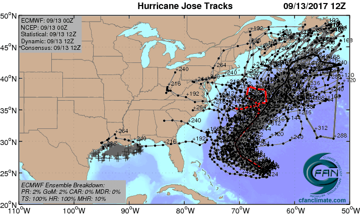
Hurricane Jose is continuing its leisurely loop over the waters a few hundred miles north of Puerto Rico, and is not expected to threaten any land areas this week. The latest computer models now say that Jose may be with us a very long time--at least another week. Jose may be a landfall threat next week for the U.S. East Coast or Canada, but that is too far in the future to make a reliable forecast. Bermuda is near the edge of Jose’s 5-day cone of uncertainty, and residents of that island should monitor the storm.

A walk inside the Eye of . Just amazing to see through the eye to the surface!
 

Intensity forecast for Jose

Jose is under high wind shear of 20 - 30 knots, and high shear is expected to affect Jose all week, keeping it a Category 1 hurricane or tropical storm. Satellite images on Wednesday morning showed that Jose still had plenty of intense heavy thunderstorm activity, but the storm was misshapen and asymmetrical due to the high wind shear. Passage over its own cold wake in the ocean may be able to weaken Jose to a tropical storm by Friday. After crossing its cold wake, Jose will be over very warm waters with sea surface temperatures (SSTs) near 29.5°C (85°F). These warm waters extend all the way to the coast of North Carolina.

Jose forecast

Jose forecast
Figure 1. The 20 track forecasts for Jose from the 0Z Wednesday, September 13, 2017 GFS model ensemble forecast. The majority of the solutions resulted in no landfall, though 6 of 20 did predict an eventual U.S. landfall. Image credit: CFAN.
Jose forecast

Jose forecast
Figure 2. The 0Z Wednesday September 13, 2017, track forecast by the operational European model for Jose (red line, adjusted by CFAN using a proprietary technique that accounts for storm movement since 0Z Wednesday), along with the track of the average of the 50 members of the European model ensemble (heavy black line), and the track forecasts from all 50 members of the ensemble. The majority of the forecasts keep Jose offshore, with the operational version of the model predicting that Jose will perform another loop. Image credit: CFAN.

Track forecast for Jose

There are two big stories today in the track forecast for Jose. Number one is the shift by the UKMET model forecast towards what the rest of the models were predicting—a motion towards the north by Jose on Friday and Saturday, which would keep Jose from making landfall in the U.S. this week. The normally reliable UKMET model had been predicting a Florida landfall late this week, and it is good to see the model going away from that outcome. The other big story is the new consensus among our long-range models that Jose will potentially be around for a long time—a week or longer.

On Wednesday morning, Jose was headed southeast at 7 mph, and was in the midst of a slow clockwise loop that it will complete by Thursday evening. (Such loops are uncommon, but not unheard of--in 2004, Hurricane Ivan did a much larger clockwise loop that resulted in two U.S. landfalls.) The slow, looping path Jose is taking in an area of weak steering currents is the sort of behavior that our computer models don’t predict with a high degree of accuracy, and the 5-day error in the latest track forecast is likely to be higher than average.

A high-pressure system will build in to the northeast of Jose late this week, and will begin steering the hurricane to the northwest and then north, between North Carolina and Bermuda, over the weekend. After that, the future track of the storm gets very murky. Jose will be in an area of weak steering currents next week in the waters several hundred miles southeast of New England, and may wander erratically off the coast all week. The large waves from the storm will be capable of causing high surf and considerable beach erosion along the shores of the mid-Atlantic and New England coasts during this period. Water temperatures within about 400 miles of the coast, from New Jersey to Maine, are generally below 26°C (79°F), which will make it difficult for Jose to intensify, fortunately. Bottom line: It’s too soon to know what Jose will do, and the storm is likely to be around for a week or longer.

Infrared satellite image of NE Pacific, 15Z 9/13/2017
Figure 3. Infrared satellite image of TD 15E and TD 16E in the eastern Pacific as of 1500Z (11 am EDT) Wednesday, September 13, 2017. Image credit: NASA/MSFC Earth Science Branch.

The first new tropical cyclones in two weeks in Eastern Pacific

While Harvey, Irma, and Jose raged across the Atlantic over the last three weeks, it’s been relatively quiet over the Eastern Pacific. This has changed with the formation of Tropical Depression 15E on Tuesday night and Tropical Depression 16E on Wednesday morning. TD 15E is the first tropical cyclone to form in the eastern Pacific since TD 14 formed on August 30 and became Tropical Storm Lidia the next day. Our last East Pacific hurricane was Kenneth, which peaked as a Category 4 on August 21.

Of our two new depressions, the immediate concern is TD 16E, located about 130 miles west-southwest of Acapulco as of 11 am EDT Wednesday. TD 16E is already moving north-northeast at 5 mph with a rich swath of moisture and widespread but relatively weak thunderstorm activity (convection). Conditions are favorable for development, but TD 16E hasn’t much time: it will be arcing into the Mexican coastline not far from Acapulco on Thursday, most likely still at depression strength. Rainfall of 5 – 10” is expected as TD 16E pushes inland, with higher localized totals possible.

Meanwhile, TD 15E was moving west through the open tropical Pacific about 900 miles southwest of Cabo San Lucas, Mexico, as of 11 am EDT Wednesday. The depression is poorly organized, and moderate wind shear of about 15 knots is hindering its growth, but its convection increased notably on Tuesday night. The 12Z Wednesday run of the SHIPS model indicates that shear across TD 15E will drop below 10 knots on Thursday and will remain light into the weekend. Since TD 15E will be over warm enough water to support development (27-28°F or 81-82°C), it has a shot at becoming a tropical storm as it continues west. Out top models have been producing only modest development of TD 15, but the 06Z run of the HWRF model intensifies the depression into a hurricane by this weekend. If so, TD 15E will need to produce a core soon enough to fend off the effects of increasingly dry air around it. In any event, TD 15E poses no threat to land.

In between 15E and 16E, we have yet another disturbance, dubbed Invest 95E, embedded in the same swath of moist air that favors development. Wind shear should remain light to moderate (around 10 knots) over the next couple of days as 95E travels over very warm waters (SSTs of 29-30°C or 84-86°F). The wind shear will be increasing by this weekend, but it is possible 95E will become a tropical storm before that point. In its tropical weather outlook issued at 8 am EDT Wednesday, NHC gave 95E a 60% chance of developing into at least a depression by Friday, and an 80% chance by Monday.

Why does the East Pacific often go quiet while the Atlantic lights up, and vice versa?

What goes up must come down, and it’s often the case that when conditions favor rising air and hurricane formation in the Atlantic, we have sinking air and reduced hurricane activity in the East Pacific. This is especially common during La Niña events, but it can also occur when the El Niño/Southern Oscillation (ENSO) is in its neutral mode. On the other hand, during El Niño, subsidence and increased wind shear become more common across the Atlantic, typically reducing hurricane activity there. Forecasters raised their predictions of an active Atlantic hurricane season this spring and summer when it became apparent that no El Niño would develop. Dr. Phil Klotzbach explained the process in an August post for the NOAA ENSO Blog.

ENSO effects on hurricanes

ENSO effects on hurricanes
Figure 4. Typical effects of El Niño abd La Niña on hurricanes across the Eastern Pacific and Atlantic. Image credit: NOAA Climate.gov, based on originals by Gerry Bell.


While ENSO is officially in a neutral mode right now (NOAA’s Michelle L’Heureux called it “extreme neutral” in August), there has since been substantial cooling of the eastern tropical Pacific. This is in conjunction with the upwelling part of a Kelvin wave (a weak but large disturbance that moves slowly east across the uppermost waters of the tropical Pacific). The latest weekly value of the Niño3.4 index is -0.6°C, which suggests enough cooling to qualify as La Niña conditions if it were to persist for a few months. Most global models in August were predicting a neutral winter for 2017-18, but the most recent runs of NOAA’s CFSv2 model strongly suggest that we are already in the onset phase of a La Niña event. As of mid-September, climate prediction models from the Australian Bureau of Meteorology (BOM) and MeteoFrance agree with CFSv2 that La Niña conditions will expand into early 2017-18. (This is based on NOAA’s definition of La Niña, which is less stringent than BOM’s.) Four other global models were still calling for a neutral 2017-18.

ENSO forecast

ENSO forecast

Figure 5. ENSO outlook from NOAA’s Climate Forecast System, version 2 (CFSv2) as of Sept. 10, 2017. The graph at left shows sea-surface temperatures across the Niño3.4 region of the eastern tropical Pacific, as predicted by the CFSv2 model ensemble (thin lines) and the model mean (black dashed line). Readings below -0.5°C are associated with La Niña, so the CFSv2 favors La Niña development for 2017-18, as shown in the sea-surface temperatures maps at right. Image credit: NOAA/NWS/CPC.

What the preppers are saying about Hurrican Jose

There is a gap between what "official" weather channels are saying and what others are saying.

I shall post Weather Underground seperately. I would say, from recent experience, that nobody really knows for sure but people in potentially-vulnerable areas like NYC should err on the side of caution and be prepared.


Hurricane Jose: 5 Days Until Impact/New York


NYC / NJ & LI Pay VERY Close Attention . . . Hurricane Jose will be NEAR


Persons in New York City, all of New Jersey and all of Long Island, NY should pay EXTREMELY CLOSE ATTENTION to the weather forecasts surrounding Hurricane Jose for the next few days.  
The National Hurricane Center is showing a PROJECTED path of Jose, traveling up along the US east coast early next week, being off the NJ shore on Tuesday.  Here's the thing:  Some of the computer models are showing the hurricane coming directly into land at NYC/NJ/New York Harbor.
As we all know, computer MODELS are just that: models.  They may not be accurate and are often NOT accurate.
But with the damage done to Houston by Hurricane Harvey, and the damage done to Florida by Hurricane Irma, it is prudent to be extremely aware of what this hurricane does over the next few days.
I remind everyone of the models for Hurricane Sandy back in 2012.  Like Jose, they showed a general path out in the Atlantic, right up until the final moments when Sandy took a sharp turn directly into New Jersey.  JOSE CAN DO THE SAME THING.
So it is important that folks in the New York City, New Jersey and Long Island areas make certain their gasoline is topped-off for all cars and trucks, spare gas cans are topped-off for emergency generators to keep refrigerators running and for some lights in the home.  That you have emergency food and water, and propane for your gas grill to cook with if this storm strikes.
Don't be like the people in Houston who waited until ONE DAY before the storm hit, to go shopping.  Within four hours, stores there were SOLD OUT of food and water.
Don't be like the people in Florida who waited til hours before the storm hit, to decide what to do, then found themselves without electric, food or water for the next several DAYS.
Be smart.  Prepare now. 
If the storm remains out at sea, you can still drink the emergency water and eat the emergency food.  But it is better to HAVE IT and not need it, than to NEED IT and not have it.


Thursday, 14 September 2017

Hurricane Jose path: Where is Hurricane Jose now? Will it hit Florida? Latest track models

Clinton News Network – "nothing to worry about". Anything's alright so long as it doesn't make landfall in 'Murika.

Hurricane Jose's looping path may bring it back toward Bahamas and US

Hurricane Irma radar


Hurricane Jose, sitting out in the Atlantic on Wednesday, is expected to make a slow clockwise rotation over the next 36 to 48 hours that could bring it closer to the US and the Bahamas.

Jose was 510 miles east-northeast of the southeastern Bahamas midday Wednesday, with maximum sustained winds of 75 mph, making it a Category 1 storm.

It's expected to remain at hurricane intensity in the Western Atlantic as it takes an odd, looping path toward the US and Bahamas later this weekend.


Most computer models indicate Jose will stay out to sea and complete a tight enough loop to avoid moving onshore. Still, the forecasts were fairly uncertain about its path and its intensity.


Hurricane Jose path: Where is Hurricane Jose now? Will it hit Florida? Latest track models

Wednesday, 13 September 2017

Atlantic storm update - 09/12/2017


This year hurricane strength and course have become more difficult to forecast and hurricanes are acting in strange ways.

A hurricane season like no other


The remnants of Hurricane Irma are not doing what forecasters thought.  Weather experts believed the remnants would move northwest into Tennessee.  Instead, they are moving west/southwest and now cover Mississippi, are entering Louisiana and heading back toward the Gulf!
One wonders if the storm could re-form upon entering Gulf Waters?

What is Jose doing?

Jose Less Threatening, But Vigilance Still Required


Dr. Jeff Masters  · 

September 12, 2017, 11:07 AM EDT
Above: GOES-16 view of Hurricane Jose at 10:15 am EDT September 12, 2017. Image credit: NOAA/RAMMB. GOES-16 data is considered preliminary and non-operational.

Hurricane Irma is dead, having lost its tropical characteristics and been declared post-tropical early Tuesday morning. But even as the search for survivors continues in the areas hard-hit by Irma, Hurricane Jose in the Atlantic needs to be closely watched. The latest computer models have trended towards taking Jose to the north by early next week, with no U.S. landfall likely. However, the hurricane is expected to come within a few hundred miles of the mid-Atlantic U.S. coast, and we must closely monitor this storm. Canada appears more likely than the U.S. to receive a hit from Jose at this point, but it is too early to be a believer in these long-range model forecasts. The Bahamas are now out of Jose’s 5-day cone of uncertainty, and high surf is the only impact they are likely to receive from the storm.

Intensity forecast for Jose


Jose is under high wind shear of 20 - 30 knots, and this high shear has degraded the storm significantly over the past three days, leaving it a Category 1 storm with 75 mph winds at 11 am EDT Tuesday. Satellite images on Tuesday morning showed that Jose still had plenty of intense heavy thunderstorm activity, but the storm was misshapen and asymmetrical due to the high wind shear. Continued moderate to high wind shear, combined with dry air and a passage over its own cold wake in the ocean, will likely weaken Jose to a tropical storm by Wednesday, despite very warm sea surface temperatures (SSTs) near 29.5°C (85°F) outside the cold wake. A relaxation in shear on Thursday and Friday may allow Jose to intensify some, but shear is expected to rise to the high range again over the weekend, which would halt the intensification process.
Jose forecast
Figure 1. The 20 track forecasts for Jose from the 0Z Tuesday, September 12, 2017 GFS model ensemble forecast. Twenty-five percent of the solutions resulted in an eventual landfall in the U.S., and another 40% did so in Canada. Image credit: CFAN.
Jose forecast
Figure 2. The 0Z Tuesday September 12, 2017, track forecast by the operational European model for Irma (red line, adjusted by CFAN using a proprietary technique that accounts for storm movement since 0Z Tuesday), along with the track of the average of the 50 members of the European model ensemble (heavy black line), and the track forecasts from the “high probability cluster” (grey lines)—the five European model ensemble members that have performed best with Jose thus far. A threat to Canada next week is the most likely outcome, according to these European model forecasts. Image credit: CFAN.

Track forecast for Jose

Jose is currently headed east at 5 mph, and is in the midst of a slow clockwise loop. (Such loops are uncommon, but not unheard of--in 2004, Hurricane Ivan did a much larger clockwise loop that resulted in two U.S. landfalls.) The rather odd forecast track is the result of a mid-level high that will move to the northeast of Jose on Wednesday, forcing it to the south and then west. The slow, looping path Jose is taking in an area of weak steering currents is the sort of behavior that our computer models don’t predict with a high degree of accuracy, and the 5-day error in the latest track forecast is likely to be higher than average. While the 12Z Monday, 0Z Tuesday, and 6Z Tuesday runs of the GFS and European models (and their ensembles) showed a limited threat to the U.S., and an increased threat to Canada next week, we should not be confident in these forecasts until Jose is done with its loop and is positioned in an area of more reliable steering currents. The UKMET model has been consistently predicting over its past three runs that Jose will move through The Bahamas and hit the U.S., but this model is an outlier, and is less likely to be correct than the consensus of our other models. Bottom line: It’s too soon to know what Jose will do, and it is certainly possible that the storm will recurve out to sea without affecting any land areas.
Seeing a favorable trend in our Calibrated ECMWF EPS that takes Hurricane #Jose out to sea. Still worth watching, but good news nevertheless pic.twitter.com/WtG9wFoyOj
Michael Ventrice (@MJVentrice) September 12, 2017

We’ll have more on Irma in a post later today.


UK Weather Forecast: Storm Aileen To Pummel Britain With 75mph Gusts

Strong winds and heavy rain en route! ⛈ ⛈ ⛈


A deepening area of low pressure will bring very strong winds across much of England and Wales during Tuesday night and into Wednesday morning.
An Amber National Severe Weather Warning is in place, warning of gusts of 55-65 mph in particular across parts of Cheshire, Lancashire, Derbyshire, Yorkshire, Nottinghamshire and Lincolnshire.  Gusts up to around 75mph gusts could also be possible in exposed locations such as the coast and hills in these areas.
has officially been named & will bring severe gales to central parts of the UK. More here

A Yellow weather warning for rain is also in place for parts of Northern Ireland, Northern England and Southern Scotland which warns of 30-40mm of rain falling within 6-9 hours which could cause some disruption.

A amber severe weather warning for has been issued:
Stay
Chief forecaster Frank Saunders said: “Storm Aileen is expected to bring strong winds of up to 75mph to a central segment of the UK and an Amber weather warning has been issued. As well as the strong winds, there will be some heavy rain pushing eastwards overnight which could see accumulations of 30-40mm. The low pressure system that is bringing these strong winds will move fairly swiftly from west to east over the UK and although there will still be some disruption through Wednesday morning, the winds will ease by the afternoon leaving a day of blustery showers.”
There has been some speculation that this weather is being driven by the severe weather in the Caribbean and US, there is no such connection. Met Office Deputy Meteorologist Chris Tubbs said: “There are no links between the very strong winds we expect to see here in the UK and the hurricanes affecting the United States and the Caribbean at present. This system originated well north in the Atlantic Ocean, independent of the current Caribbean hurricanes”.
As Storm Aileen clears out eastwards into the North Sea, the UK will be left with cool showery conditions through the end of the week and into the weekend. The showers will still be blustery on Thursday with the winds easing as we get closer to the weekend. Within the showers there will be some periods of brightness although it will still feel cool across the whole of the UK with top temperatures only reaching 18-19°C
The storm names for 2017-18 have been announced, Aileen is first on the list. More here


Charleston, S.C. Submerged by Irma Flooding


Despite being downgraded to a tropical storm, former hurricane Irma sent four feet (1.2 metres) of ocean water into downtown Charleston, South Carolina on Monday. (Sept. 12)

US Navy Dispatched to Florida Keys for Search & Rescue after Hurricane Irma


The United States Navy dispatched the USS Iwo Jima, USS New York and the aircraft carrier Abraham Lincoln to the Florida Keys help with search and rescue and other relief efforts.

President Trump sent the aircraft carrier and other Navy ships on Monday as a flyover of the hurricane-battered Keys yielded what the governor said were scenes of devastation. This gives all the Keys a fully functional airport - instantly - and numerous helicopters which will speed rescue efforts.

"I just hope everyone survived," Gov. Rick Scott said.

He said boats were cast ashore, water, sewers and electricity were knocked out, and "I don't think I saw one trailer park where almost everything wasn't overturned." Authorities also struggled to clear the single highway connecting the string of islands to the mainland.

The Keys felt Irma's full fury when the storm blew ashore as a Category 4 hurricane Sunday morning with 130 mph (209 kph) winds. How many people in the dangerously exposed, low-lying islands defied evacuation orders and stayed behind, was unclear.

Emergency managers in the islands declared on Monday "the Keys are not open for business" and warned that there was no fuel, electricity, running water or cell service and that supplies were low and anxiety high.

"HELP IS ON THE WAY," they promised on Facebook.

The Keys are linked by 42 bridges that have to be checked for safety before motorists can be allowed in, officials said. The governor said the route also needs to be cleared of debris and sand, but should be usable fairly quickly.

Over the next two days, Irma is expected to push to the northwest, into Alabama, Mississippi and Tennessee.

People in the heavily populated Tampa-St. Petersburg area had braced for the first direct hit from a major hurricane since 1921. But by the time Irma arrived in the middle of the night Monday, its winds were down to 100 mph (161 kph) or less.

"When that sun came out this morning and the damage was minimal, it became a good day," said Tampa Mayor Bob Buckhorn.