Showing posts with label Californai. Show all posts

Thursday, 16 January 2014

The dying Pacific

Sardine vanish off the coast; squid and anchovy fill the void for fishermen


Longtime bait fisherman Mike Spears is near the net aboard the In-Seine at 3 a.m. Saturday off the shores of Marina del Rey. With the decline in sardines off of our coast — probably just due to the changing cycle of the ocean — fishermen have been relying on anchovies to fill the void. But there aren’t quite enough anchovies to make up for the loss of sardines and, in fact, on Saturday, the anchovy catch was zero. (Brittany Murray / Staff Photographer)


19 January, 2014


Larry Derr was as prepared as any longtime Southern California bait fisherman for the disappearance of the Pacific sardines he has pulled up by the ton since the 1980s.

He can fish anchovies instead and, if those become scarce, there’s been a local surge in market squid to keep him in business.

But the fickle sardines have been so abundant for so many years — sometimes holding court as the most plentiful fish in coastal waters — that it was a shock when he couldn’t find one of the shiny silver-blue coastal fish all summer, even though this isn’t the first time they’ve vanished.

And the similar, but smaller, anchovies have proven a poor replacement since sardines became scarce. Fortunately, a boom in market squid has propelled Derr and other coastal pelagic fishers.

In three days of nighttime fishing last week, Derr barely cleared a measly 20 scoops of anchovies to sell.

“A couple days ago we caught a ton of anchovies,” Derr said, keeping a vigilant eye for the telltale red mass on the In-Seine’s sonar during a predawn hunt Saturday. The screen remained black with irregularly dispersed green dots representing schools too small to fish. “We want this to be solid red.”

Though sardines aren’t as valuable as tuna or rockfish, they’re an important food source for larger fish, marine mammals like sea lions, dolphins and whales, and sea birds that can spot them from the air and dive for them. Some have attributed recent rashes of sea lion pup and pelican deaths to the sardine population decline, which began a few years ago and was officially recognized in December when the fishing quota was dropped to just 5,446 metric tons for all of California, Oregon and Washington from January to June. In the same time period last year, the quota was 18,073 metric tons.

The Pacific Fishery Management Council lowered the quota in November after years of sardine stock decline from 2006, when 1.4 million tons were estimated to be swimming around the north Pacific. This year, their numbers are believed to be less than 400,000 metric tons.

This isn’t the first sardine fishery collapse. A booming sardine fishery based in Monterey’s Cannery Row ended suddenly when the fish simply stopped appearing in their usual haunts. The loss of the fishery, partially chronicled in John Steinbeck’s 1945 novel “Cannery Row,” was a shock to the local economy.

Decades of research into what happened to the sardines and whether overfishing was to blame followed. Then, sardines started appearing as by-catch in the 1980s. By the 1990s, they were back in full force and — except for some low points — have remained so plentiful that “you could almost close your eyes, throw out a net and find sardines everywhere,” Derr said.

Kerry Griffin, staff officer on coastal pelagic fish species for the National Oceanic and Atmospheric Administration, said all sardine fishing will be banned if the population estimate decreases by about half of what it is now.

For now, environmental scientists are looking to April, when they will have an updated assessment of the amount of living sardines.

“Is it El Nino? Pacific Decadal Oscillation? El Nina? Long-term climate change? More marine mammals eating sardines? Did they all go to Mexico or farther offshore?” Griffin said. “We don’t know. We’re pretty sure the overall population has declined. We manage them pretty conservatively because we don’t want to end up with another Cannery Row so, as the population declines, we curb fishing.”

There is heated debate surrounding the sardine decline. Some environmentalists believe they have been overfished in recent years, though the scientists who monitor them generally say the fish simply haven’t tolerate cooler waters well — a theory based on the temperature of coastal waters dubbed Pacific Decadal Oscillation.

Russ Vetter, director of the Fisheries Resource Division at NOAA’s Southwest Fisheries Science Center, said the most probable scenario is that cooler waters made it harder for the babies to survive.

“They haven’t had a good recruitment,” Vetter said, referring to the survival of young sardines. “You have to have adults that produce the eggs and then environmental conditions that would allow them to grow and then to not have them eaten by pelicans and terns, etc. It’s always complicated about why a fish egg doesn’t make it through the problems but we do know that, when the ocean is on the cooler side, conditions aren’t right.”

In the meantime, most fishers are concentrating their efforts on market squid, which are now plentiful. Anchovies and mackerel are also filling the void locally.

“Everybody’s calling me every day for sardines,” Derr said. “They’re all gone. Even Monterey Bay Aquarium is still waiting for some to restock one of their exhibits.”

While scientists debate when and if the sardines will return, Vetter said no one can know for sure. The fish reproduce so rapidly that their numbers can boom incredibly fast, he said.

In the meantime, the appearance of large numbers of squid has kept fishers in San Pedro, Redondo Beach and Marina del Rey happy.

“But, if the squid go away, it’s a real problem if they can’t fall back on something else to fish for,” Griffin said.


Monday, 6 January 2014

North California radiation

CALIFORNIA BEACH RADIATION NOT FROM FUKUSHIMA


5 January, 2014

A lot of concern has been expressed about recent reports and videos showing high levels of radiation on a beach in Half Moon Bay, just South of Pillar Point Harbor.  It has been attributed  to Fukushima.  Local officials have been quoted as saying they donʻt know what it is, but donʻt worry about it.  


Here is what we have learned so far:   The radioactive areas of the beach seem to be associated with dark sand below the high tide level.   The levels detected are about 5 to 10 times what you would normally expect to find on a beach.

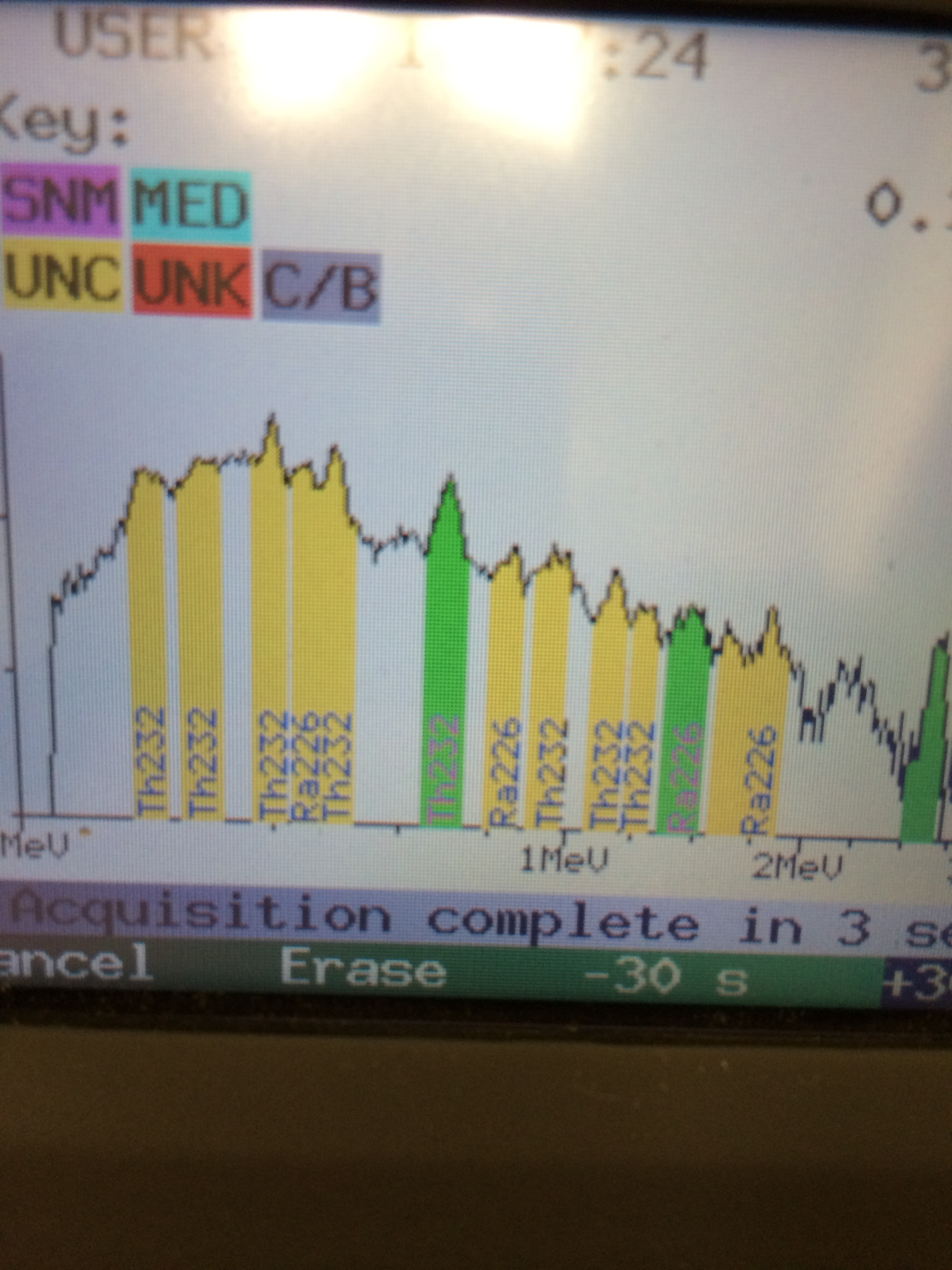
The radionuclides are in the NORM class of radioactive substances, not from Fukushima. NORM stands for Naturally Occurring Radioactive Material.   We put a sample in a Multichannel Analyzer and found Radium 226 and Thorium 232.  See the measured spectra below.

This is the spectra from the beach sample
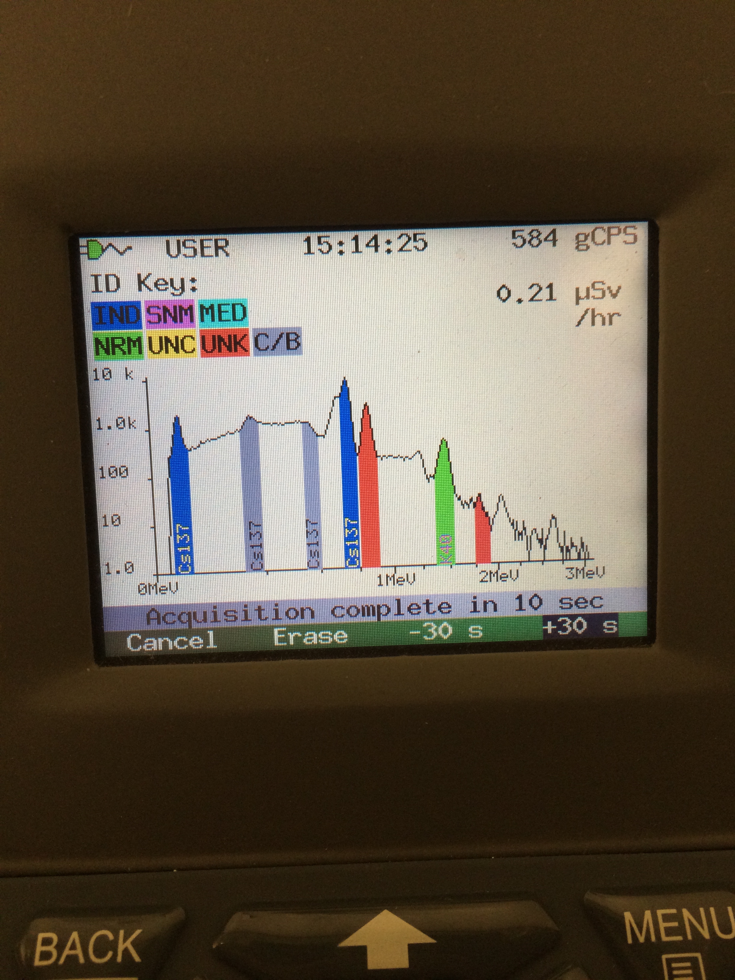
If the sand were contaminated by radiation from Fukushima it would show Cesium 137. See spectra below from contaminated area of Fukushima Prefecture.  The same instrument is identifying Cesium 137 rather than Radium and Thorium.
Sample of deck material from contaminated area of Fukushima Prefecture
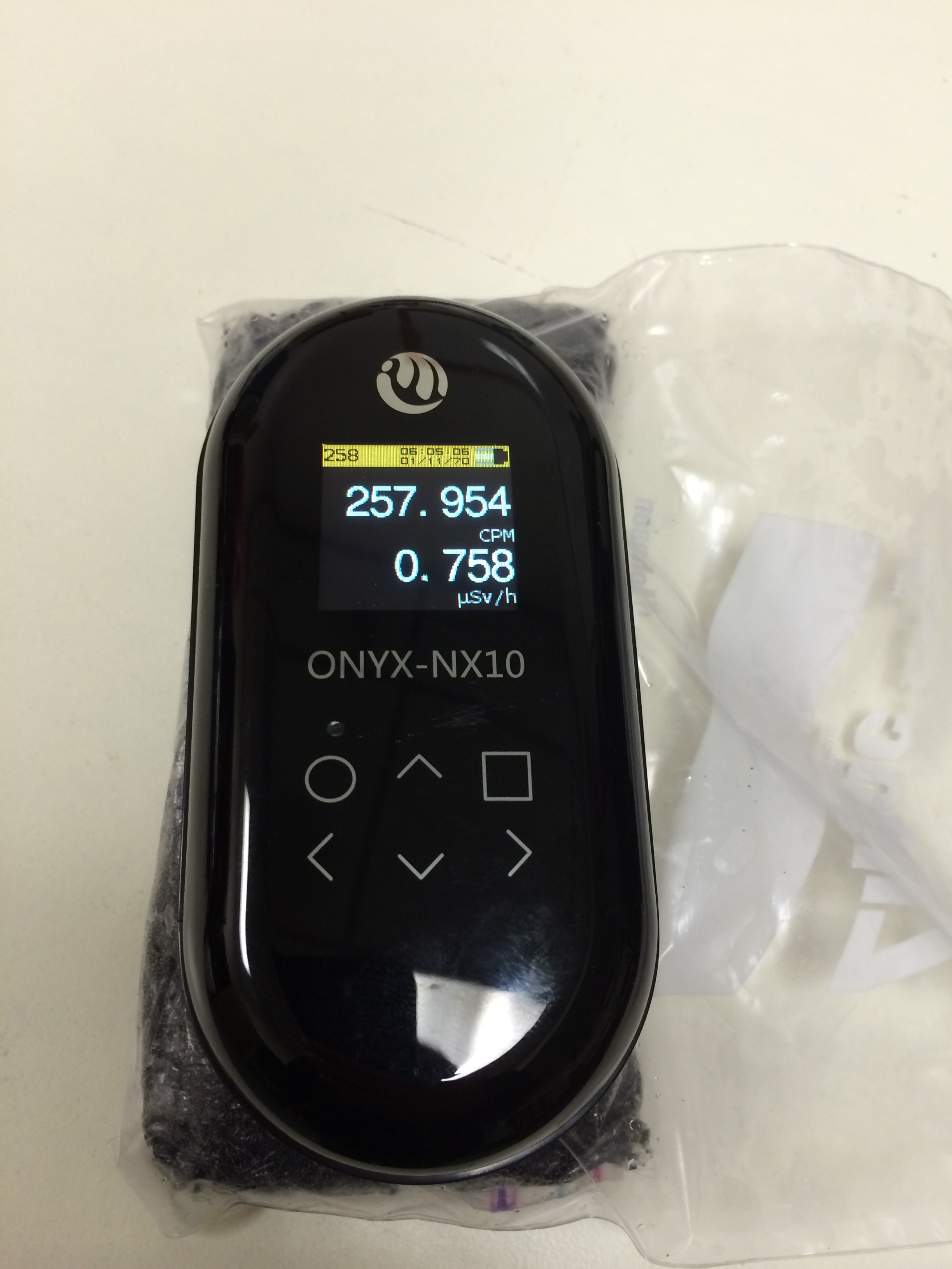
The picture below is a geiger counter measuring the activity in a sample bag of the sand. The radiation level is elevated, but roughly equivalent to some granite counter top material from Brazil.
IMG_6644
This is a geiger counter with 2 inch pancake detector measuring the activity in the sand sample
Whether this material is naturally occurring at this beach or not remains a question. There are also reports that a pipeline was once at this location.  We hope the State will do further testing to determine the origin and full nature of the hot spots on the beach. But we are confident that it is not related to Fukushima, based on the spectral signature.  We expect more news later today.


From earlier

Health officials respond to beach radiation scare


3 January, 2014


An amateur video of a Geiger counter showing what appear to be high radiation levels at a Coastside beach has drawn the attention of local, state and federal public health officials. Since being posted last week, the short video has galvanized public concerns that radioactive material could be landing on the local coastline after traveling from Japan as a result of the 2011 meltdown of the Fukushima Daiichi reactors.


Government officials say they are looking into the video shot on Dec. 23 and performing their own sampling of the beaches, but they have found no indication so far that radiation levels were hazardous.

“It’s not something that we feel is an immediate public health concern,” said Dean Peterson, county environmental health director. “We’re not even close to the point of saying that any of this is from Fukushima.”

First posted last week on YouTube, the seven-minute video shows the meter of a Geiger counter as an off-camera man measures different spots on the beach south of Pillar Point Harbor. The gadget’s alarm begins ringing as its radiation reading ratchets up to about 150 counts per minute, or roughly five times the typical amount found in the environment.

Counts per minute is a standard way for Geiger counters to measure radiation, but it does not directly equate to the strength or its hazard level to humans. Those factors depend on the type of radioactive particles and isotope.

Nonetheless, the video went viral online, gaining nearly 400,000 views in the last week.

In a blog entry, the unidentified poster of the video noted that he has been monitoring local beaches for two years before noticing a sudden rise in radiation levels in recent days. The Review was not immediately able to contact the man who made the video.

In the following days, other amateurs with Geiger counters began posting similar videos online. The videos follow other alarming news last month that starfish were mysteriously disintegrating along the West Coast, a trend that has not been linked yet to any cause. Past computer simulations had indicated that radioactive cesium-137 from the Fukushima reactors could begin appearing on West Coast shores by early 2014. Those findings, published in August by the Institute for Cross-Disciplinary Physics and Complex Systems in Spain, also noted that any radioactive material that crossed the Pacific would likely be diluted and fall below international safety levels.

County health officials first learned of the radiation levels last week, and they sent their own inspector on Dec. 28 to Pacifica with a Geiger counter. Using a different unit, the county inspector measured the beach to have a radiation level of about 100 micro-REM per hour, or about five times the normal amount. REM stands for “Roentgen equivalent man,” a measurement of the dosage and statistical biological effects presented by radiation.

Although the radiation levels were clearly higher than is typical, Peterson emphasized that it was still not unsafe for humans. A person would need to be exposed to 100 microREMs of radiation for 50,000 hours before it surpassed safety guidelines by the Occupational Safety and Health Administration, he explained.

Peterson admitted he was “befuddled” as to why radiation levels were higher than normal, but he was skeptical that the Fukushima meltdown could be the cause. He noted that many innocuous items could spike the radiation levels in an area, including red-painted disposable eating utensils.

“I honestly think the end result of this is that it’s just higher levels of background radiation,” he said.

Peterson forwarded the matter to the U.S. Environmental Protection Agency and state Department of Public Health, agencies with more expertise on analyzing radioactivity.

A state Public Health spokeswoman said her office was contacted on Thursday and was still looking into the matter. More information would be available by next week, she said.

“We can’t comment on anybody’s media creation. We really have no way of knowing right now whether it’s valid or not,” said spokeswoman Wendy Hopkins.

Wednesday, 1 January 2014

Drought in California

A woeful year of rainfall may bring water limits for 2014


30 December, 2013

Over what should have been the two rainy seasons, weather patterns have conspired to send our moisture elsewhere, meteorologists say.

As a result, water managers are beginning to worry that the rains might not return this year at all, spelling another nasty dry year. The Sonoma County Water Agency is awaiting word from the state on its request to slash flows from Lake Mendocino into the Russian River, a way of preserving the dwindling supply in the reservoir.

They're also planning an aggressive and unusual winter-time conservation campaign, which should debut to customers next week, urging residents to limit water usage, including cutting out outdoor irrigation and car washing.

“We're trying to add to the tools we have available to us” to save water, Chief Engineer Jay Jasperse said. “Currently we don't have a lot of tools.”

At the start 2013, the Jet Stream, the great river of wind in the atmosphere, formed its usual huge wintertime loop, but it started its northbound leg hundreds of miles east of its normal spot in the mid-Pacific, causing the wet weather that usually hits the West Coast on the downside to fall instead far inland, over the Rockies.

Since late October, meanwhile, a stubborn high pressure system has been hugging the coast of the Pacific Northwest, shunting all that lovely moist air that usually blows across the California coast in the fall northward, where it is giving coastal Alaska and British Columbia an unusually wet and cold fall and winter.

“That's the rain we would love to see come down here,” said California State Climatologist Michael Anderson.

This weather year — July 1 through June 30, 2014 — is shaping up to be the driest on record across most of the state, including the North Coast, according to many indicators. As of Dec. 29, Santa Rosa Airport had recorded just 2.43 inches of rain since July 1; by this time last year, that figure was 21.81 inches, according the Western Weather Group, a private meteorology group based in Chico.

Since Jan. 1, Santa Rosa has seen just 8.71 inches of rain, according to Press Democrat records, compared to an annual average of 32.22 inches.

As of mid-December, the upper reaches of the Russian River had received significantly less rain this year than either 1976 or 1932, previously the two worst drought years in the past 119 years, according to data from the Ukiah station of the National Climatic Data Center.

The status of the Russian River north of Lake Mendocino is further hampered by the near absence of water at Lake Pillsbury on the Eel River system. For decades, some water from that reservoir has been diverted into the Russian River. Right now, Lake Pillsbury is at less than 13 percent of capacity.

Weather forecaster Accuweather reports that San Francisco has had 3.3 inches of rain, just 16 percent of its normal. Of all cities in California, only San Diego has received even half of its normal rainfall for the year.

In the Russian River watershed, Lake Mendocino near Ukiah is down to 39 percent of capacity, according to the Water Agency. That's a serious situation if the rains don't return, but Jasperse and his staff at the agency are beginning to contemplate the previously unthinkable. What happens if another dry season brings the huge Lake Sonoma northwest of Healdsburg to a critical level?

Lake Sonoma, the mainstay of the region's water supply, is at 70 percent capacity, with about 171,000 acre-feet, or 55.7 billion gallons. The region uses more than 5,000 acre feet per month and the agency is required to start rationing water to the cities it supplies when capacity hits 100,000 acre feet.

That means that without more rain or a significant effort to cut down on water usage, Lake Sonoma has only a bit more than a year's worth of storage before managers are forced to impose limits on its customers, which are the cities and towns of southern Sonoma County and northern Marin County.

The growing concern about a continued dry spell is not misplaced, at least in the short term, said National Weather Service Meteorologist Michelle Mead. Over the next seven days or so, about as far out as anyone is willing to predict with certainly, that high pressure system off the coast will keep diverting any moisture-causing weather far off to the north, the way a goal keeper deflects incoming hockey pucks.

“If you think of the ridge of high pressure as a goalie, it keeps California dry and warm,” she said.

In the longer term, there might be a little bit of hope. The high pressure system has begun to weaken in recent days, making it possible it might break up or retreat westward into the Pacific, which it did for a few days in early December, giving us the brief cold snap that included a welcome dusting of snow on the mountains, Anderson said.

And conditions can change fairly quickly, he said. This time of year is one of the key moments when long-term weather patterns tend to shift, and climate models are giving roughly even chances of dry, normal, or wet conditions in Northern California over the next three months.

Some climate models had predicted some rain around Jan. 9, he said, but that possibility seems to have slipped away over the last few days.

More tantalizingly, some models suggest that the Pacific may be about to slip into the warm, wet condition known as “El Niño,” after a decade in which the opposite, the cool, dry “La Niña” pattern has held sway most years.

Should an El Niño develop, he said, it could spell rain as early as March, though it might not be until next fall that the effects begin to be felt.

Unfortunately, he said, the science of predicting weather that far out is maddeningly primitive, with scientists just beginning to see and understand the titanic air and sea patterns that govern West Coast weather.

“We really don't understand how all those pieces fit together yet,” he said.


California enters third consecutive dry winter, statewide drought worst on record 
‘Lack of rain and snow this winter could bring catastrophic losses to California agriculture’

droughtFI
California’s Central Valley—prime agricultural land—is being hit the hardest by the state-wide drought which could cause catastrophic losses to crops and food supply.


27 December, 2013


The city of Los Angeles has received only 3.6 inches of rain this year—far below its average of 14.91 inches, USA Today reported. And San Francisco is experiencing its driest year since record keeping began in 1849. As of November, the city had only received 3.95 inches of rain since the year began.

The state is enduring its driest year on record and while a drought emergency has not yet been officially declared, the U.S. National Drought Monitor shows that as of Dec. 24, nearly the entire state is gripped by severe to extreme drought conditions.

The portion of the state currently hit hardest by drought includes the Central Valley, a prime agricultural area, and “a lack of rain and snow this winter could bring catastrophic losses to California agriculture, as water allotments are slashed by state agencies,” USA Today reported.

The lack of precipitation is also extending what’s been a devastating wildfire season in California. According to AccuWeather, fire season usually tapers off in the fall and December marks the beginning of the wet season, which usually extends through March. This year, however, looks to be different.

“It will remain dry through February and probably early March in California,” Lead Long-Range Forecaster Paul Pastelok said. “It’s possible that a system or two could reach the state, but not enough to put a dent in the drought.”

As a result, wildfire risk remains high. Mid-December’s Big Sur Fire scorched through more than 900 acres and destroyed dozens of homes before it was contained.

“The cause of the blaze is under investigation, but there was little doubt among firefighters that the rare December inferno is a manifestation of an exceedingly dry year,” the San Francisco Chronicle reported. Like much of California, the area is experiencing its driest calendar year on record. “Big Sur has received just half an inch of rain since the seasonal calendar began in July, according to the National Weather Service. The area normally receives nearly eight inches by this time.”

The prolonged drought also poses a serious risk to the state’s water supply. Due to a string of warm, dry winters and the declining snowpack that they bring, many of the state’s northern reservoirs have been stuck at precariously low levels this year, some dwindling to just one-third or one-half capacity.

“Going forward, continued dry conditions will not build the snowpack critically needed for this year’s water supplies,” the California Department of Water Resources posted on its website this week.

Citing the the abnormal late fire season activity and very low soil moisture, the agency said Gov. Brown (D-CA) had formed an Interagency Drought Task Force to assess conditions, allocations and whether a declaration of statewide drought was needed. In recent weeks, several state and federal lawmakers have written to Gov. Brown and President Obama asking them to declare a drought emergency and federal disaster in the state.

“This is going to be a very challenging water year for California and a potentially catastrophic year for the Central Valley in particular,” Sen. Feinstein (D-CA) and Rep. Costa (D-CA) wrote.