Tracking
Aussie Twin Cyclones, Methane & EQ Report with Margo (Mar. 22,
2019)
Margo
goes over new methane data from Monday, March 18, 2019, continues
tracking Australian Cyclones Trevor & Veronica, goes over YT
comments and reviews recent earthquakes worldwide
Show
Links:
https://www.cyclocane.com/trevor-stor...
https://www.cyclocane.com/veronica-st...
https://blogs.nasa.gov/hurricanes/201...
https://blogs.nasa.gov/hurricanes/201...
https://www.abc.net.au/news/2019-03-2...
https://www.abc.net.au/news/2019-03-2...
https://twitter.com/breakingweather/s...
https://guymcpherson.com/2019/03/edge...
‘Very
destructive’ Cyclone Trevor crosses NT coast
Cyclone
Trevor has hit the Northern Territory mainland, with “very
destructive” winds of 175km/h up to a “wild” 250km/h.
23 march, 2019
Cyclone Trevor has arrived.
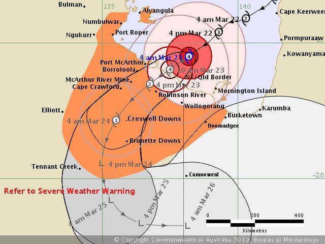
The Bureau of Meteorology said the category four storm cell was “starting to make landfall” between Port McArthur and the Northern Territory-Queensland border at 11:20am on Saturday.
“Sustained winds of 95km/h gusting to 115km/h at #CentreIsland, just off the coast near #Borroloola, very destructive wind speed of 175km/h near the centre, gusting to a wild 250km/h!” the Bureau of Meteorology wrote.
Borroloola is nearly 1000km southeast of Darwin. “If you’re in Trevor’s path you’ve made all the necessary preparations and now is the time to stay safe and remain in shelter,” a Bureau of Meteorology spokesman said in a video update.
The warning zone extends from Groote Eylandt in the north-west of the Gulf all the way inland to Tennant Creek, 1000km south of Darwin, and across the border to Burketown on the Queensland side of the border, 500km from Borroloola.
“It’s so important that you stay inside and don’t leave safety as the cyclone’s calm eye passes overhead,” the spokesman said. “Very soon the winds will rapidly increase from the opposite direction to just as fast or even stronger than before.”
Trevor is also expected to produce heavy rain and tidal surges. The storm core was just south of the Pellew Islands, while the system stretched to Mornington Island in Queensland.
The cyclone, moving west southwest at 19km/h, was expected to weaken as it hits the coast and be a category two system by Saturday evening.
NT Emergency Services’ Jason Collins said anyone remaining in Trevor’s path needs to have supplies to last at least three days, take shelter and stay away from waterways.
“Turn around, don’t drown. We may not be there to save you,” he said. “Emergency services are stretched.”
By Sunday afternoon, forecasters believe Trevor will weaken below cyclone strength and reach Tennant Creek as a tropical low in the evening.
“It’s going to take quite a while to weaken because it is quite a physically large system and intense system at the moment,” Mr Kennedy said.
“It is expected when it moves to land to start weakening, definitely. But probably at least this time tomorrow, it’s still likely to be cyclone- strength, producing gale force winds over water and tracking a fair way inland.”
He said Groote Eylandt communities had been “spared the brunt of it”, with the less inhabited south of the island experiencing strong winds.

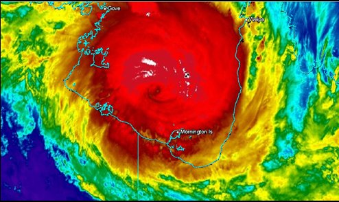
Satellite image from BOM showing tropical Cyclone Trevor bearing down on NT coast.Source:Supplied
Thousands of residents in the cyclone’s path have been evacuated, including the entire coastline from Numbulwar to the Northern Territory-Queensland border.
Two-thousand one hundred people from East Arnhem Land have also registered at emergency evacuation centres, with 1200 sleeping at cyclone shelters across the Territory and the remainder choosing to stay with family, friends or in accommodation.
Ahead of the approaching storms, the state has launched its largest evacuation since Cyclone Tracy hit in 1974. The eye of Cyclone Trevor is forecast to be 30-50 kilometres wide, while the entire system spans roughly 200km.
Residents have been warned to expect gale-force winds, rain and tidal surges 300 kilometres out from its core, the Bureau of Meteorology says.
Current predictions suggest the cyclone will move more than 400 kilometres inland before it weakens to a tropical storm.
Trevor left behind a trail of damage in Queensland’s Cape York Peninsula earlier this week, uprooting trees, causing flooding and roof damage, closing schools and roads, and knocking out power supplies.

Tropical Cyclone Forecast Track Map for Severe Tropical Cyclone Trevor. Picture: BOMSource:Supplied
CYCLONE VERONICA
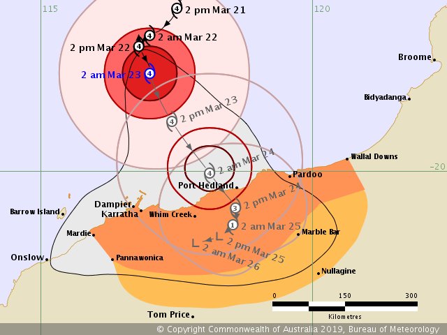
Over in Western Australia, along the Pilbara coast are also preparing for a category four storm to make landfall within the next 24 hours.
Cyclone Veronica is set cross the Pilbara coastline between Karratha and Port Hedland late tonight or very early tomorrow morning, bringing with her wind gusts of up to 275km/h and major storm tides.
BOM meteorologist Jonathan How told Today this morning that the heavy rainfall caused by Cyclone Veronica could cause flooding of up to one metre in height.


No comments:
Post a Comment
Note: only a member of this blog may post a comment.