Cyclone Oma may merge with southerly change to create massive weather system - forecaster
Newshub,
20
February, 2019
Two
large weather systems may merge over New Zealand later this week,
bringing wild wind and heavy downpours of rain to northern regions.
Meteorologists
remain unable to predict whether Cyclone Oma, a category three
cyclone currently moving past the northern tip of New Caledonia, will
hit New Zealand.
NIWA
forecaster Chris Brandolino suggests there are two possible
scenarios, with both ending with a likelihood of significant rain and
wind for Aotearoa.
"One
scenario has [Cyclone Oma] going towards the Queensland coast, kind
of just loitering out for the next several days, not really making it
down to New Zealand," he told The AM Show on Tuesday.
Mr
Brandolino said, under that scenario some "moisture" from
the cyclone will peel off and hit New Zealand's northern regions,
with another incoming weather system adding to the wild weather.
"That
scenario also includes a separate weather system which comes Sunday
or Monday, a southerly change. That brings some pretty good wind or
rain for New Zealand".
The second scenario would see Oma making its way to New Zealand and "merging with the aforementioned southerly change".
That
could create a massive weather system over the country, with Mr
Brandolino saying the "atmospheric synergy" would produce
something that was "greater than the sum of its parts".
"You
get a much larger system - either scenario is probably going to
produce some pretty significant weather."

Mr Brandolino's forecast reflects comments from Weatherwatch on Monday that suggest this coming weekend could be the wettest yet this year.
"The
weather will get worse from Friday, and we'll see some rain which is
great news with all the fire bans and water restrictions we've been
seeing," said meteorologist Lisa Murray.
Tropical Cyclone Oma now category 3, changes course for Queensland
-
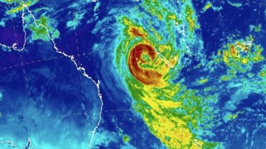
Tropical Cyclone Oma was about 1120 kilometres north-east of Brisbane on Wednesday morning.
-
Some
of the weather bureau's modelling previously predicted TC Oma to
head south for New Zealand, but it was expected to head west towards
Queensland.
-
It
strengthened to a category 3 system overnight, which could result in
roof and structural damage, mass power failures and destructive wind
gusts in excess of 165km/h.
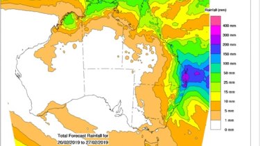
- The system was likely to whip up dangerous swells, significantly erode southern Queensland beaches and dump isolated falls of 300 millimetres.
- The Bureau of Meteorology's forecast path map showed Cyclone Oma would weaken to a category 2 system on Friday as it made its final approach to the coast.

BrisbaneTimes,
20 February, 2019
Tropical Cyclone Oma has strengthened to category 3 and is expected to come close to the south-east Queensland coast and potentially make landfall.
Meteorologist Adam Blazak said a cyclone watch could be issued on Wednesday afternoon, on top of the hazardous surf warnings already in place.

Tropical Cyclone Oma's size as shown by satellite images.CREDIT:BUREAU OF METEOROLOGY
On Tuesday, some of the weather bureau's modelling predicted the tropical cyclone to track west towards Queensland, while other models showed it was likely to head south for New Zealand.
The system is likely to whip up dangerous swells, significantly erode beaches, dump isolated falls of 300 millimetres and bring wind gusts faster than 100km/h.
Differences between models make it difficult to tell how bad the impact will be and where. One run on Tuesday of the European model had as much as 1500 millimetres being dumped over western Brisbane.

No comments:
Post a Comment
Note: only a member of this blog may post a comment.