Arctic
temperatures soar 45 degrees above normal, flooded by extremely mild air on all
sides
By Jason Samenow

The temperature difference from normal over the Arctic averaged over the next five days in the GFS model forecast. (University of Maine Climate Reanalyzer)
21
February, 2018
While the
Eastern United States simmers in some of its warmest February weather ever
recorded, the Arctic is also stewing in temperatures more than 45 degrees above
normal. This latest huge temperature spike in the Arctic is another
striking indicator of its rapidly transforming climate.
On Monday and Tuesday, the
northernmost weather station in the world, Cape Morris Jesup at the
northern tip of Greenland, experienced more than 24 hours of temperatures
above freezing according
to the Danish Meteorological Institute.
“How weird is
that?” tweeted Robert
Rohde, a physicist at the University of California at Berkeley.
“Well it’s Arctic winter. The sun set in October and won’t be seen again until
March. Perpetual night, but still above freezing.”
This thaw
occurred as a pulse of extremely mild air shot through the Greenland Sea.
Warm air is
spilling into the Arctic from all sides. On the opposite end of North America,
abnormally mild air also poured over northern Alaska on Tuesday, where the
temperature in Utqiaġvik, previously known as Barrow, soared to a record
high of 31 degrees (minus-1 Celsius), 40 degrees (22 Celsius) above normal.
For Feb 20th, (unofficial) average daily temperature departure-from-normal for North Slope locales: Umiat: +45F (+25C) , Deadhorse +44F, Nuiqsut: +43F, Wainwright: +40F Utqiaġvik: +39F, Kaktovik +35F. #akwx @Climatologist49 @CinderBDT907
The warmth over Alaska occurred as
almost one-third of the ice covering the Bering Sea off Alaska’s West Coast
vanished in just over a week during the middle of February, InsideClimateNews
reported.
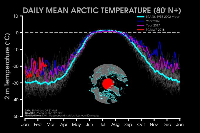
Temperatures over the entire Arctic
north of 80 degrees latitude have averaged about 10 degrees (6
Celsius) above normal since the beginning of the calendar
year, sometimes spiking over 25 degrees (14 Celsius) above normal (the
normal temperature is around minus-22, or minus-30 Celsius).
These kinds
of temperature anomalies in the Arctic have become commonplace in winter in
the past few years. “[T]he *persistence* of the above average temperatures is
quite striking,” tweeted Zack Labe, a PhD candidate in climate science at the
University of California at Irvine.
While there is always large variability in the #Arctic winter, the *persistence* of the above average temperatures is quite striking in the last few years.
Average is the light blue line. Gray lines indicate years from 1958-2015 [>80°N latitude; sites.uci.edu/zlabe/arctic-t…].
While
there is always large variability in the #Arctic winter, the
*persistence* of the above average temperatures is quite striking in the last
few years.
Some of the
most extreme warmth of the year so far is forecast to flood the Arctic in
coming days, with a number of areas seeing temperatures that
exceed 45 degrees (25 Celsius) above normal (dark pink shades below) and
up to 60 degrees (34 Celsius) above normal. The mercury at the North Pole could
well rise above freezing between Thursday and Sunday.
This next batch of abnormally warm
air is forecast to shoot the gap between Greenland and northern Europe through
the Greenland and Barents seas. Similar circumstances occurred in
December 2016, when the temperature at the North Pole last flirted
with the melting point in the dark, dead of winter. We documented similarly
large jumps in temperature in November 2016 and December 2015.
An analysis from
Climate Central said these extreme winter warming events in the
Arctic, once rare, could become commonplace if the planet continues
warming. A study in the journal Nature published
in 2016 found the decline of sea ice in the Arctic “is making
it easier for weather systems to transport this heat polewards.”
Arctic sea ice was at its lowest extent
on record this past January, according to the
National Oceanic and Atmospheric Administration.
“I have sailed boats through [the
Arctic Sea] but never this time of year,” tweeted David
Thoreson, an Arctic photographer. “It’s amazing to watch this
unfold.”
The
record-setting temperatures and lack of ice is exactly what scientists have
projected over the Arctic for years and it’s fundamentally changing the
landscape.
“Arctic shows no sign of returning to
reliably frozen region of recent past decades,” NOAA concluded in its Arctic
Report Card, published in
December.


No comments:
Post a Comment
Note: only a member of this blog may post a comment.