Extremely Warm Cyclone Predicted to Drive 50-60 F Above Average Temperatures Across North Pole
31
January, 2018
Our
lexicon of what’s considered to be normal weather does not include
February days in which temperatures at a North Pole shrouded in
24-hour darkness cross into above freezing ranges. But that’s
exactly what some of our more accurate weather models are predicting
will happen over the next five days.
Another
Unusually Warm and Powerful Storm
During
this time, a powerful 950 to 960 mb low is expected to develop over
Baffin Bay. Hurling hurricane force gusts running from the south and
digging deep across the North Atlantic, Barents, and Arctic Ocean,
the low is projected to drive a knife of 50-60 F above average
temperatures toward the North Pole by February 5th.
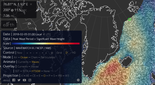
(20-25
foot surf heading for the increasingly fragile sea ice in this
February 4 wave model forecast. Note the 30-40 foot waves off Iceland
and associated with the same storm system that is predicted to bring
above freezing temperatures to the North Pole on February 5th. Image
source: Earth
Nullschool.)
These
warm winds are predicted to bring above freezing temperatures to
areas that typically see -20 to -30 F readings in February. They are
expected to rage over a sea ice pack that is at record low levels.
And if the storm emerges, it will hammer that same dwindling ice pack
with 20 to 25 foot or higher surf.
Fragile
Arctic Sea Ice Faces a Hammering
Presently,
Arctic sea ice extent is trending about 200,000 square kilometers
below record lows set just last year for the period of late February.
And recent
scientific research indicates that warm winter storms like the one
that is now predicted to form can have a detrimental impact on sea
ice.
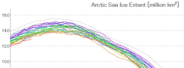
(Arctic
sea ice extent is presently at around 13 million square kilometers
[bottom red line] — a new record low for this time of year. It
should be around 15 million square kilometers and would be if the
world hadn’t warmed considerably since the 1980s. Image
source: JAXA.)
Not
only do the storms bring warmer temperatures with them — a kind of
heat wave that interrupts the typical period of winter freezing —
they also drive heavy surf into a thinner and weaker ice pack. The
surf, drawn up from the south churns warmer water up from the ocean
depths. And the net effect can dissolve or weaken large sections of
ice.
The
presently developing event is expected to begin to take shape on
February 4th, with warm gale and hurricane force winds driving above
freezing temperatures near or over the North Pole on February 4th –
6th. To say that such an event, should it occur, would be practically
unprecedented is the common understatement of our time. In other
words, this is not typical winter weather for the North Pole. It is
instead something we would expect to see from a global climate that
is rapidly warming and undergoing serious systemic changes.
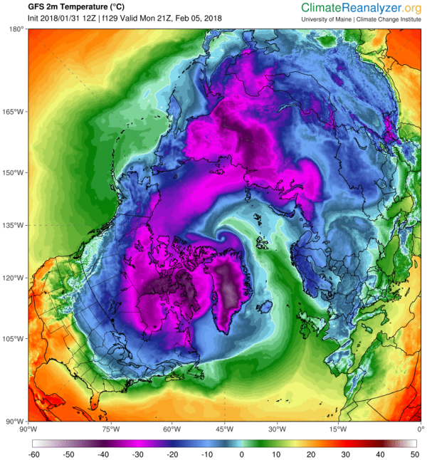
(February
5 GFS model run shows above freezing temperatures crossing the North
Pole. Temperatures in this range are between 50 and 60 degrees [F]
above average for this time of year. If the extremely warm cyclone
event occurs as predicted, it will be a clear record-breaker. It will
also further harm Arctic sea ice levels that are already in record
low ranges. Image source: Climate
Reanalyzer.)
Extreme
Cyclone Beneath an Extreme Jet Stream
In
the predicted forecast we see more of the extreme jet stream
waves that
Dr. Jennifer Francis predicted as an upshot of human-forced polar
amplification (a
condition where the poles warm faster than the rest of the globe
under a larger warming regime). The particular wave in question for
the present forecast involves a high amplitude ridge running very far
to the north over Svalbard and knifing on into the high Arctic. The
facing trough over Baffin Bay, Greenland, and North America is also
quite pronounced and elongated. A feature that appears to want to
become a cut off bubble of displaced polar air in a number of the
model forecasts.
High
amplitude Jet Stream waves during Northern Hemisphere winter as a
signature of global warming are predicted by Francis and others to
generate greater temperature and precipitation extremes in the middle
latitudes. They are a feature of the kind of stuck and/or upside down
weather we’ve been experiencing lately where temperatures in the
Northeast have been periodically colder than typically frigid
locations in Alaska. These flash freezes have, at times, faded back
into odd balmy days in the 50s and 60s (F) before plunging back into
cold. But
the overall pattern appears to get stuck this way for extended
periods of time.
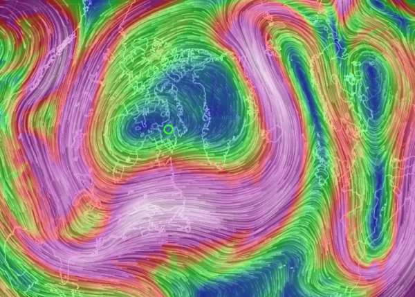
(Very
high amplitude ridge and trough pattern at the Jet Stream level of
the circumpolar winds is thought by a number of scientists to be a
feature of human caused global warming. One that is related to polar
amplification in the Arctic. Image source: Earth Nullschool.)
Heat
in the Arctic is driving sections of cold air south even as warm air
invades through places like Alaska, Northeast Siberia, and the
Barents Sea. But the main variables of this story are global heat,
global warming, fixed extreme temperature and precipitation patterns,
and warm air invasion. The winnowing streamers of cold air driven out
over places like the U.S. Northeast are just a side effect of the
overall warming trend. One that is starkly apparent in the very odd
western warmth that has grown more and more entrenched with each
passing year.
For
Now, It’s Still Just a Forecast
As
with any five day forecast, we can take this one with more than just
a grain of salt at the present time. But such an extreme event is
entirely possible during the present age of human-forced climate
change. During late December of 2015, we
identified a predicted major storm that ultimately drove North Pole
temperatures to above freezing.
At the time, that storm was considered unusual if not unprecedented.
However, since February is typically a colder period for the North
Pole region, a warm storm drawing above freezing air into that zone
would be even more unusual. It would also be a feature of the larger
trend of loss of typical seasonal winter weather that we’ve been
experiencing for some time now.


No comments:
Post a Comment
Note: only a member of this blog may post a comment.