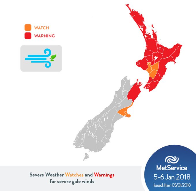
Wild
weather in New Zealand.
We
had some rain here in Wellington overnight which has taken the
temperatures down from about 28C to 26C.
The
wild weather is still to hit us here.
You know the Anglo-Saxons and how they talk about the weather. We had a birthday party yesterday and the one thing people DIDN'T talk about was the weather.
Any talk of climate change is totally taboo.
The
wild weather has claimed its first death after a large tree fell on a
woman's car in Rotorua.

WHAT YOU NEED TO KNOW:
* A woman has died after a tree fell onto a car in Rotorua.
* According to NIWA, since 9am Thursday, 41mm of rain fell in Auckland - more than the total amount of rain in November and December combined.
* State Highway 25 between Thames and Manaia is closed due to slips and rock falls.
* The overnight downpour has forced the closure of State Highway 1 to Kaikōura until further notice.
* Part of Auckland's Tamaki Drive has been closed due to water spilling on the road.
* People in low-laying parts of the Firth of Thames are being told to urgently self-evacuate.
* MetService expect the worst of the severe weather to be over by midday tomorrow.
5
January, 2017
The
storm has also been battering much of the North Island and some of
the South Island.
MetService
said earlier today that the summer storm is far from over and will
actually strengthen.
'Everything has just dried up'
The
deluge of rain expected to hit most of the country this week is
unlikely to help regions plagued by water shortages, officials say.
5
January, 2018
Several
districts - including Coromandel, Horowhenua, Wellington and Otago -
have recently put
water restrictions in place,
following months of extremely hot and dry weather.
While
some were hoping the heavy rain forecast for later tonight may
provide a bit of relief, many officials say it won't last long enough
to make a difference.
Residents
in the Horowhenua towns of Levin and Ohau were being urged to
conserve water as the dry weather they have experienced since
mid-October has seen river flows become critically low.
The
Horowhenua District Council has imposed restrictions, meaning
residents must not use sprinklers and hoses for their gardens or
pools, or to clean their cars and windows.
Water
services engineer Maurice McGunnigle said it was something they had
not had to do in years.
"Speaking
with the contractor and operators, who have lived in the area for the
last 20 or 30 years, it's very unusual to have an early summer like
we've had at the moment. Everything has just dried up, we've had
hardly any rain and the groundwater levels have reduced a great
deal."
He
said rain was need, but a short burst might not help much.
"I
think more than anything we would be hoping for low intensity
rainfall that lasts for a long period, so it can have time to soak
into the ground, and then as more water eventually kind of holds in
the ground and it builds again.
Even if we get a short sharp period
of rain over the next few days, there might be an increase in the
Ohau River levels, but that might only last a couple of days, and the
river level will drop again.
"I'd
say you'd probably need at least a week of continuous rain."
He
said in the meantime, everyone should play their part to ensure water
levels did not get too low.
"Every
little bit helps because it does mount up and it helps everyone in
the community and not just the residents but the businesses as well
they have to operate and by keeping a watchful eye on our water usage
it can help immensely."
Similar
restrictions are in place in Wellington, where there's now a ban
on household use of garden sprinklers and other irrigation
systems until
further notice.
Further
south, the Queenstown Lakes District Council yesterday imposed
restrictions as reservoir levels dropped rapidly, but it said
residents acted quickly to conserve water and the reservoir was able
to replenish overnight.
In
Coromandel, sprinklers, hoses and irrigation are also banned
in several townships,
including in Pauanui, Matarangi and Coromandel Town.
Thames-Coromandel
District Council infrastructure manager Bruce Hinson said thousands
of holidaymakers flocking to the region were putting added strain on
the water supply.
He
said it was common for the season, but streams and groundwater levels
were much lower than they would normally be leading into the period.
"At
this time of year we can have anything up to five or six times the
number of people that we would normally have on the peninsula, and so
in a lot of our townships where we have suppliers from groundwater
bores or quite small streams, it puts quite a lot of pressure on. So
we just try to manage this demand over those short couple of weeks
over the summer period."
Mr
Hinson said the heavy rain forecast would not help in short term, and
could even make things more difficult.
"When
you get this kind of rain, the streams get quite dirty and they get
additional dirt sediment runoff from all the hills and that gets into
the stream.
And what that means is that it makes it harder for the
water treatment plant to produce clean drinking water."
NIWA
forecaster Chris Brandolino said a long bout of rain was needed for
parched regions.
"A
very dry ground can often be like cement. It does get absorbed, but
not nearly as much as if it were a gentle or more spaced-out
rainfall, with the runoff too it also causes an elevated risk of
flooding, because the streams and rivers steal that runoff as opposed
to going into the ground.
"So
yes, it will help. But not much as it would have if it was over say
two or three or four days."

Thanks Robin. Horses OK?
ReplyDelete