From Record Floods to Drought in Three Months: Unusually Hot, Dry Conditions Blanket South
4
December, 2017
Back
during late August of 2017, Hurricane
Harvey dumped as much as 60.48 inches of rain over southeast Texas.
Harvey was the wettest tropical cyclone on record ever to strike the
U.S. — burying Houston and the surrounding region under multiple
feet of water, resulting in the loss of 91 souls, and inflicting more
than 198 billion dollars in damages.
Harvey
was the costliest natural disaster ever to strike the U.S. Its
tropical rains were the heaviest ever seen since we started keeping a
record. But strangely, almost inexplicably, just a little more than
three months later, the region of southeast Texas is now facing
moderate drought conditions.
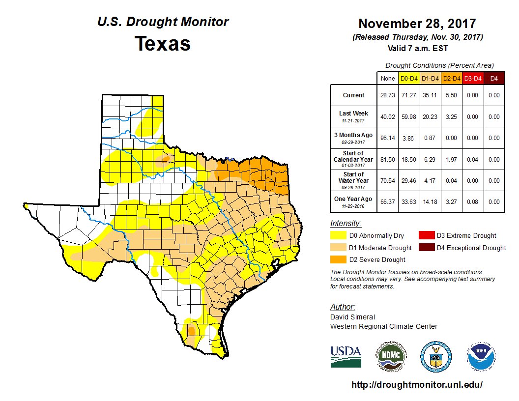
(Just
three months after Harvey’s record rains, Southeast Texas is
experiencing drought. No, this is not quite normal despite a mild La
Nina exerting a drying influence. Image source:U.S.
Drought Monitor. Hat
tip to Eric Holthaus.)
How
did this happen? How did so much water disappear so soon? How could
an instance of one of the most severe floods due to rainfall the U.S.
has ever experienced turn so hard back to drought in so short a time?
In
a sentence — climate change appears to be amplifying a natural
switch to warmer, drier weather conditions associated with La Nina.
Climate
change, by adding heat to the Earth’s atmosphere and oceans
fundamentally changes the flow of moisture between the air, the ocean
and the land. It increases the intensity of both evaporation and
precipitation. But this increase isn’t even. It is more likely to
come about in extreme events. In
other words, climate change increases the likelihood of both more
extreme drought and more extreme rainfall.
Of
course, climate change does not exist in a vacuum. Base weather and
climate conditions influence climate change’s impact. At present,
with La Nina emerging in the Pacific, the tendency for the southern
U.S. would be to experience warmer and drier conditions. But in a
normal climate, these conditions would tend to be milder. In the
present climate — warmed up by fossil fuel burning — the tendency
is, moreso, to turn toward an extreme. In this case, an extreme on
the hot and dry end of the climate spectrum.
For
the region of Southeast Texas flooded so recently by Harvey’s
record rains, it means that a turn from far too wet to rather too dry
took just a little more than 3 months.
(Both
temperature and moisture took a very hard turn over the past 30 days.
Such extremely warm and dry conditions increase the likelihood of
flash drought. A
climate feature that has become far more frequent as the Earth has
warmed.
Image source: NOAA.)
South
Texas, however, is just one pin in the map of a larger trend toward
drought that is now blanketing the South. Over the past month,
precipitation levels were less than 50 percent of normal amounts in
most locations with a broad region over the south and west
experiencing less than 10 percent of the normal allotment of
moisture. Meanwhile, 90-day
precipitation averages are also much lower than normal across the
South.
Precipitation
is a primary factor determining drought. But temperature can mitigate
or worsen drought conditions. Higher temperatures cause swifter
evaporation — driving moisture out of soils at a faster rate. And
average temperatures across the south have been quite warm
recently. With
one month averages ranging from 1 C above normal over most of the
south to a whopping 8 C above normal over parts of New Mexico.
As with lower than normal precipitation, higher than normal
temperatures have also extended into
the past 90 day period across most of the South.
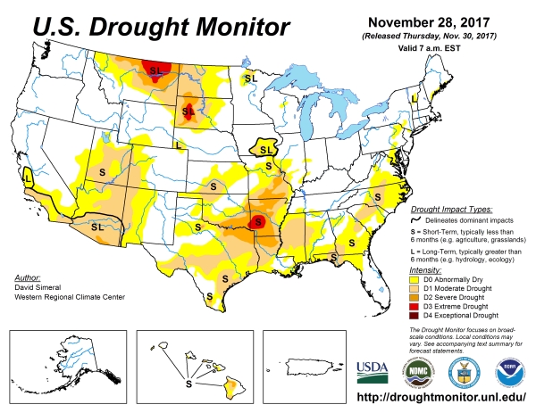
(Moderate
drought conditions are widespread as severe to extreme drought is
starting to crop up in the South-Central U.S. With La Nina likely to
continue through winter and with global temperatures in the range of
1.1 to 1.2 C above pre-industrial averages, there is risk that
conditions will intensify. Image source: U.S.
Drought Monitor.)
The
upshot is that moderate drought is taking hold, not just in southeast
Texas, but across the southwest, the southeast, and south-central
U.S. Severe to extreme drought has also already blossomed from
northern Texas and Louisiana through Oklahoma, Arkansas and Missouri.
This is relatively early to see such a sharp turn, especially
considering the fact that La Nina conditions have only lasted for a
short while and have, so far, been
rather mild on the scale of that particular climate event.
Furthermore,
like Texas, many of these drying regions experienced extreme rainfall
events during spring and summer. Such events, however, were not
enough to stave off a hard shift to drought in a world in which
human-caused climate change is now driving both droughts and more
extreme rainfall events to rising intensity.
(Predicted
temperature and precipitation variance from normal over next three
months. Climate change is likely to enhance this variability related
feature. Image source: NOAA.)
With
La Nina likely to remain in place throughout winter,
the typical climate tendency would be for continued above average
temperatures across the south and continued below average rainfall
for the same region. Present human-caused global warming through
fossil fuel burning in
the range of 1.1 to 1.2 C above pre-industrial averages will
tend to continue to amplify this warm, dry end of the natural
variability cycle (for the southern U.S.).
In
other words, there is not insignificant risk that the hard turn away
from record wet conditions in the South will continue and that severe
to very severe drought conditions will tend to spring up and expand.
RELATED
STATEMENTS:


No comments:
Post a Comment
Note: only a member of this blog may post a comment.