Warm Atmospheric River Aims Parade of Storms at U.S. West During La Nina Year of 2017
17
January, 2017
A
river of moisture arises from the Pacific Ocean and links up with a
procession of enormous storms that bring heavy surf, flooding rains,
and mountain snows to the U.S. West. It’s a weather narrative that
one usually associates with a strong El Nino during winter time. But
the powerful El Nino ended last year and it failed to bring the
expected rains. Meanwhile, in early 2017, during a La Nina year in
which typical trends would tend to point to drier conditions for the
U.S. West, a procession of severe storms is now slamming into
California.
El
Nino Pattern During a La Nina Year
So
what the heck happened? What could possibly cause such a crazy
weather flip-flop in which record drought conditions extend through a
time of El Nino but severe and extreme rains come with the onset of
La Nina?
The
answer appears to be that a record warm ocean combined with a
strongly positive Pacific Decadal Oscillation to produce a powerful
river of moisture aimed directly at California. And when the
associated storms arrived it
was with an extreme intensity —
setting off numerous flash flood events.
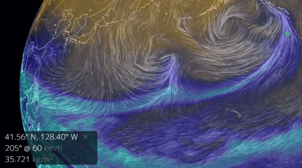
(Water
vapor models show an atmospheric river running out of the Western
Pacific — crossing that vast ocean before engorging storms slamming
into the U.S. West Coast on January 17 of 2017. This is a severe
weather feature more typical of an El Nino year that is now occurring
during a period of weak La Nina conditions. The difference being that
rivers of moisture running into California typically issue over
Hawaii. The present ‘Pineapple Express’ is coming all the way
from the Philippines. Image source: Earth
Nullschool.)
An
almost continuous spate of heavy downpours since the first week of
January has
now unloaded enough moisture to fully slake severe drought conditions
over Northern California and to considerably reduce the drought in
the south. Overall,
precipitation totals for the past 30 days have been as
much as 2.5 times above the normal amount for California.
Another
Batch of Heavy Rain on the Way
This
week, NOAA expects another batch of powerful storms to come blasting
out of the Pacific. Sections of Southern California are predicted to
get hit with around 9-13 inches of rain over the next seven days
while the north receives another 10 to 15 inches. These are notably
severe rainfall totals for California. And
NOAA model predictions have
tended to range higher over the past 24 hours.
(NOAA
7-day precipitation forecast indicates a severe rainfall event for
the U.S. West Coast with heaviest amounts hitting parts of Northern
California. Image source: NOAA.)
According
to Accuweather, the
heavy rains are expected to spur flash flooding, increase the risk of
mudslides and to possibly push some rivers over their banks.
However, since many rivers are still at low levels following
persistent drought during the last five years, over-topping is less
of a risk than it otherwise would have been.
Storms
tend to bring cooler weather to this region and the Western U.S. has
cooled somewhat during 2017 compared to past years.
However, the conditions in which these storms are firing are warmer
than they have been in the past. As a result, mountain snowfall has
occurred higher up on the slopes. Consistent with the warmer than
normal storms, Accuweather predicts this
week’s storm system will not produce big snowfall totals for the
Cascades as snow levels are driven above 7,000 feet by the warmer
than usual temperatures.
Very
Warm, Moist Pacific; Positive Pacific Decadal Oscillation
There’s
been very little weather and climate discussion as to why heavy rains
are falling in California during a year when the odds stacked against
such an event would tend to be higher due to La Nina. The elephant in
the room at this time is a
major excursion of global surface temperatures in the range of 1.2 C
above normal during 2016.
A notably severe climate change related insult to the Earth system.
Such extreme atmospheric warmth will tend to hold more water vapor
aloft in suspension. As a result, when the rains do fall, they will
tend to be heavier and come more in the form of downpours and deluges
than as moderate or lighter precipitation.
(This
sea surface temperature anomaly map shows that despite La Nina, the
Pacific Ocean, on balance, is much warmer than normal. These warmer
than normal sea surfaces are pumping out a considerable amount of
moisture — which is helping to feed the powerful storm systems
running into the U.S. West Coast. Image source: Earth
Nullschool.)
To
this point, despite a La Nina blanketing the Pacific’s central
Equatorial region in cooler than normal waters, most of the Northern
Pacific is considerably warmer than normal. And all this extra warmth
is helping to pump a lot of water vapor into the atmosphere above the
ocean zone. A feature that is not typically consistent with La Nina,
but one that is consistent with a considerably positive Pacific
Decadal Oscillation acting
in conjunction with overall global warming. Positive
Pacific Decadal Oscillation (PDO) values are associated with above
normal sea surface temperatures in the Eastern and South-Central
Pacific.
Positive PDO tends to produce longer and strong El Nino events. And
it is also associated with strong storm tracks running from west to
east along the 40 N latitude line.
Storm
Track Runs All the Way to U.S. West Coast
To
this point, it’s worth noting that PDO has been in a positive
range for the past three years running. But it wasn’t until
recently that a persistently strong storm track stretching all the
way to the U.S. West Coast has developed. During past years, strong
storms veered north into Alaska and Canada, deflected by powerful
ridges over the U.S. West.
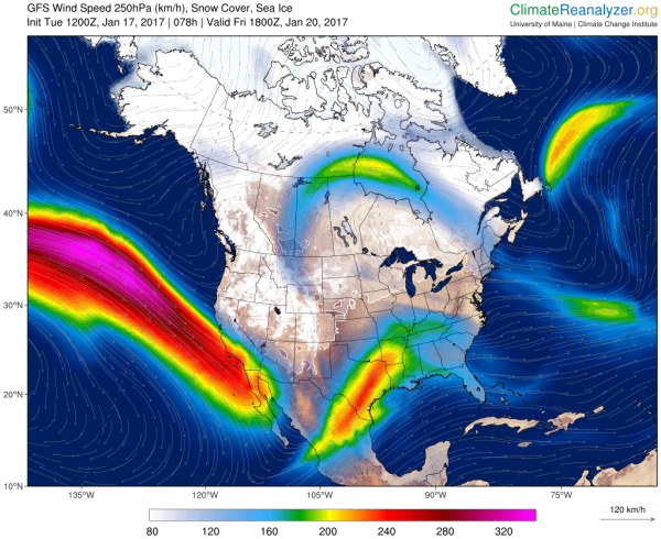
(The
crazy, wavy jet stream with a strong storm track hitting California
and a ridge riding up into Central Canada is rather changed from the
Ridiculously Resilient Ridge blocking pattern that helped to spark
severe droughts along the U.S. West Coast during 2013-2015. Now,
severe flooding rains are the rule of the day. Under human-caused
climate change, we can expect weather patterns to tend more toward
extremes. For the U.S. West Coast extreme drought has been replaced
by heavy rains. Image source: Climate
Reanalyzer.)
Assisting
the process of storms running toward the U.S. West Coast was the
removal of a hot blob of water off coastal Washington and Oregon as a
zone of somewhat cooler than normal waters formed. These cooler
waters extended from just off Northern Japan to south of the
Aleutians and on toward the U.S. West Coast. This zone is
providing a dipole temperature anomaly between the cooler than normal
surface waters in the north and the warmer than normal waters in the
south. As a result, the Jet Stream has a nice slot along which to
produce a powerful, flat storm track. These two features — a strong
temperature dipole between the 40 and 50 degree latitude lines and a
very warm Pacific producing copious amounts of moisture south of the
40 degree latitude line — are the key ingredients that appear to be
fueling the powerful West Coast storms in a counter-La Nina fashion.
In
contrast to the 2013 to 2015 period, high pressure ridging along the
U.S. West Coast is not now strong enough to deflect the storms
running across the Northern Pacific. In other words, it appears that
the influence of the Ridiculously Resilient Ridge and hot Ocean blobs
off Washington and Oregon during 2013 to 2015 is has now faded out.
However, the new climate and weather trends driving this most recent
influx of heavy rainfall to the U.S. West Coast are almost as odd and
notable.
Links:
Hat
tip to Colorado Bob


No comments:
Post a Comment
Note: only a member of this blog may post a comment.