Just
24 hours after a 7.5 earthquake the top of the South Island and the
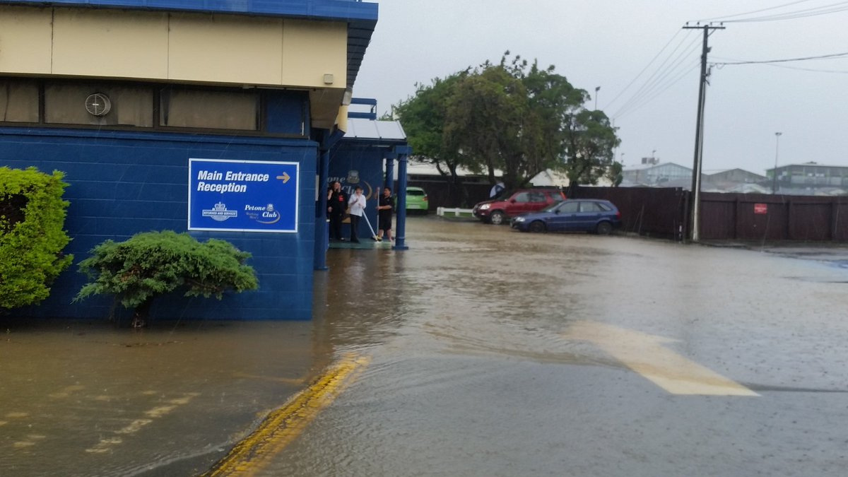
capital city experienced major flooding
Evacuations
in Hutt Valley as stream floods
People
in the Hutt Valley are being evacuated as the Waiwhetu Stream floods.
15
November, 2016
Wellington
is also being badly affected, with roads closing, rivers swelling,
and winds buffeting a capital dealing with loosened glass from the
quake.
Twelve
schools, four libraries and two clubhouses are also shut.
Wellington,
still being rattled by aftershocks last night, has faced rain for 24
hours.
New
Zealand Transport Agency (NZTA) said several roads in the region had
been closed.
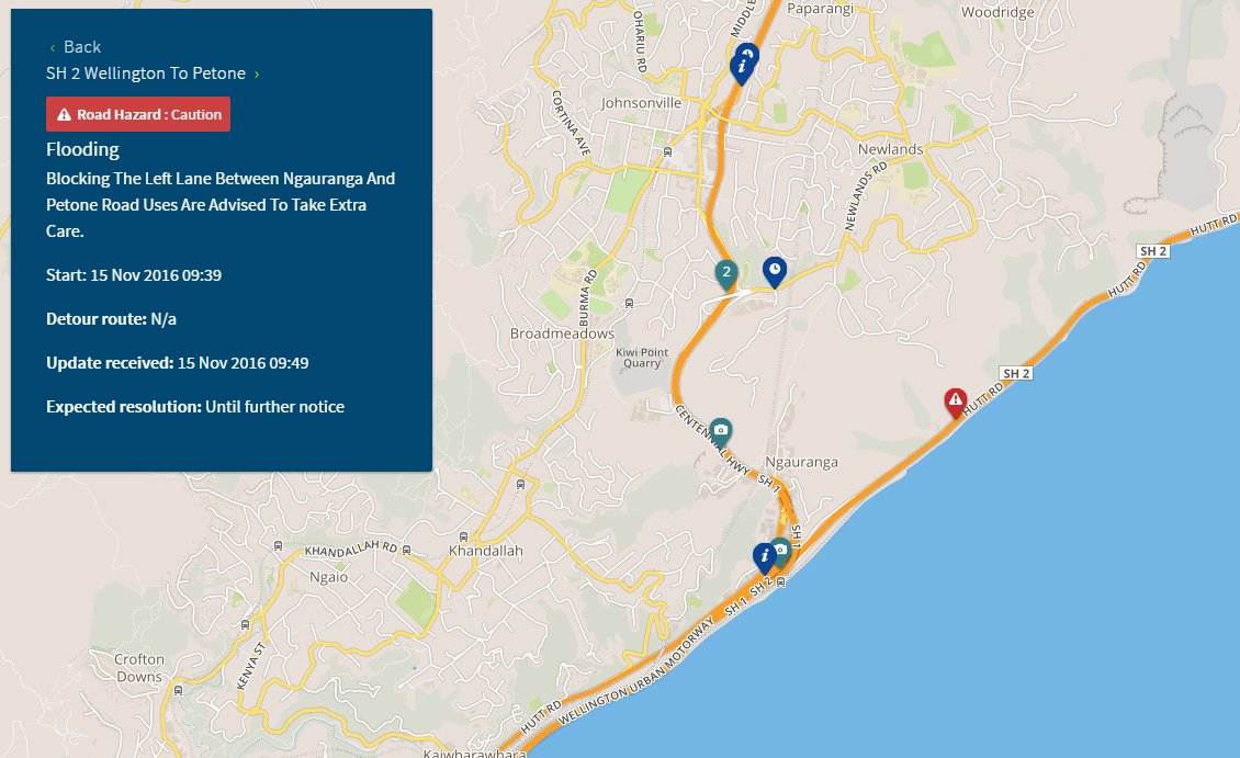
SH1
between Mackays Crossing and Paremata
SH2
between Ngauranga and Petone closed northbound
SH58
from Paremata to Haywards Interchange at SH2
Grey Road
Paekakariki
Hill Road
Rail
services between Wellington and Petone have been suspended until
further notice due to the flooding.
While
rain was beginning to ease, the MetService said, Wellington was only
11mm off its monthly record.
Traffic
was backing up around Petone, Ngauranga and Paremata.
In
Hutt City, civil defence told people to prepare to evacuate their
homes due to flooding of Waiwhetu Stream.
Flooding of Waiwhetu Stream, Hutt City. Residents should prepare to evacuate or evacuate now to friends or family or Walter Nash Stadium.
The
agency advised road users to avoid the Mana/Paremata areas north of
Wellington due to slips and flooding.
Police
said motorists from Porirua and Kapiti Coast were asked to avoid any
unnecessary travel and motorists from the Hutt Valley should take
extreme care.
The
road policing manager for Wellington, Mike Wright, said motorists
should avoid any unnecessary travel.
"If
you're at work, stay at work, if you're home- stay home.
"Please,
just exercise tolerance and patience and take your directions from
the staff that are at respective road closure sites, trying to turn
people around."
The
Plimmerton roundabout was under water but some motorists were making
their way through.
Grays
Road and Paekakariki Hill Road in Porirua and State Highway 58 over
the Haywards Hill have been closed until further notice.
Police
said contractors in the worse affected areas were managing traffic
and motorists should follow their instructions.
Train
services in the Wellington region have also been disrupted due to
flooding and slips.
Kapiti
Line trains between Plimmerton and Waikanae were cancelled, with no
services available.
Kenepuru
Station in Porirua and Taita Station in Lower Hutt were closed due to
flooding.
A
heavy rainfall warning is also still in place in the region, with the
Hutt Valley bearing the brunt of that overnight.
In
the Hutt Valley, 68.3mm of rain fell in 24 hours - almost twice as
much as was recorded there over the weekend.
The
rain is expected to ease off around the middle of the day, but heavy
falls may continue slightly longer on the Kapiti Coast.
Fire
Service Wellington shift manager Mike Wanoa said they had received
weather related calls from as far north as Taranaki since midnight.
He
said several houses have been flooded in the Hutt Valley, Porirua,
Plimmerton and Paremata.
"Numerous
houses have been flooded, basements, water rising around the streams
in the Hutt Valley, which are threatening properties. Several houses
have been evacuated as a result of that. There's surface flooding in
many of the areas."
Mike
Wanoa said in the Hutt Valley, the flooding is mostly concentrated
around the Naenae, central Hutt area.
First
alarms have been triggered for the Hutt River and Porirua Stream
indicating water levels are rising, but the Wellington Region
Emergency Management team said it was not too significant.
Wellington
Civil Defence controller Bruce Pepperell said there were three levels
of alarms, and first alarms happened several times a year.
The
Lower Hutt Riverbank car park closed due to flooding, which Mr
Pepperell said was what usually happened in these situations.
Mr
Pepperell said emergency centres were on stand by.
#SH58 across the Haywards is closed now, but here's a photo from a friend who tried to get across a little while ago.
Wind
gusts up to 130km/h were recorded on the Rimutaka Hill Road at 6am.
NIWA
said it was likely gale-force winds in Wellington could be strong
enough to do damage to things already shaken loose by the
earthquakes.
Some
of the capital's central city streets are shut due to fears the gales
could further damage buildings and send glass flying, and NIWA
forecaster Chris Brandolino said with winds in excess of 110km/h,
that was a distinct possibility.
Both
the rain and wind were expected to ease in Wellington later in the
day.
Marlborough
Wet
conditions are also making life more difficult in Marlborough, which
was badly hit by the 7.5
magnitude earthquake that struck near Hanmer Springs at 12.02am on
Monday.
Marlborough
Civil Defence Controller Richard McNamara told Morning
Report flooding was
possible between Blenheim and Nelson, and people may need to be
evacuated this morning if sandbags proved to be inadequate.
The
highway between Blenheim and Nelson has closed due to flooding in
Canvastown.
Emergency
services reported earlier that the Pelorus River had breached its
banks and evacuations were planned in the Canvastown area.
A
cordon has been placed on State Highway 6 at the Wairau Bridge and
traffic heading to Nelson is being diverted through State Highway 63
through the Wairau Valley to St Arnaud.
The
area is also at the mercy of severe northwest gales, gusting at up to
130km/h.
Kaikoura, which
is cut off from the rest of the country by major landslides,
was likely to have clear weather later today, MetService forecasts.
Otago
Steady
rain in Otago has triggered flood alerts.
Pomahaka
River in South Otago triggered two flood warnings this morning,
though seems to have peaked.
The
Otago regional council said rivers had also risen in North Otago.
It
said heavy rain was forecast for tomorrow and Thursday, and would
fall on sodden ground, so there was a risk of flooding later in the
week.
Forecasts
elsewhere
Severe
gale northwest winds were also expected in exposed parts of Taranaki
and Wairarapa.
Heavy
rain is also expected in the eastern ranges of Bay of Plenty, where
MetService expects 120mm of rain to fall from this afternoon and
through the night.
MetService
warned that people in Bay of Plenty, as well as Wellington to
Horowhenua and the central North Island hill country, should watch
for rivers and streams that may rise rapidly and could cause slips
and surface flooding.
Heavy
rain in northwest Nelson, Buller, Westland and the Bryant and
Richmond Ranges has eaed.
Christchurch,
which was also shaken by yesterday's quake, is likely to escape the
bad weather, with dry conditions expected.
 WREMO
WREMO


 NZTA Wellington
 Tayla O'Meara


 KateGudsell


 Mikaela


Glad you sound to be safe Robin. Thanks for the update.
ReplyDeleteThank you Phorus Castana!
Delete