A Monster 2016 Arctic Melt Season May Have Already Begun
******
22
February, 2016
We
have never seen heat like this before in the Arctic. Words whose
meaning tends to blur due to the fact that, these days, such events
keep happening over and over and over again.
Ever
since at least the 1920s, the Arctic has been warming up due to a
destructive and irresponsible human greenhouse gas emission.
And, over recent years, the Arctic has been warming more and more
rapidly as
those dangerous emissions continued to build on into the 21st
Century.
Now the Earth has been shoved by those emissions into realms far
outside her typical Holocene context. And it appears that the
Winter of 2016, for the Arctic, has been the hottest such year during
any period of human-based record-keeping and probably the hottest
season the Arctic has experienced in at least 150,000 years.
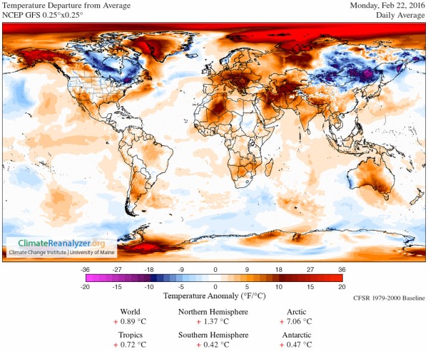
(Climate
Reanalyzer hits a stunning 7.06 C above the already hotter than
normal 1979 to 2000 baseline for the entire region above the 66 North
Latitude Line on February 22nd of 2016. It’s a very extreme
temperature departure — one this particular analyst has never seen
before in this record. For reference, a 3 C above baseline
temperature departure for this region would be considered
extraordinarily warm. What we see now is freakish, outlandish, odd,
disturbing. Image source: Climate
Reanalyzer.)
It’s
just the most recent marker on a path toward an ever-worsening
polar heat that is becoming all-the-more difficult to ignore or deny.
For at current greenhouse gas levels, that polar zone is hurtling
toward temperatures not seen in 15 million years. A heat pressure
that will push for warming not seen in 20, 30, 50 million years or
more, if
a nightmarish fossil fuel burning continues.
Nothing
in the recent geological past can compare to the danger we are now in
the process of bringing to bear upon our world. Not the Great Flood.
Not the end of the last ice age. Those were comfortable, normal
cataclysms. Human beings and life on this world survived them. But
the kind of geophysical changes we — meaning
those of us who are forcing the rest of us to keep burning fossil
fuels —
are inflicting upon the Earth is something entirely new. Something
far, far more deadly.
Extreme
Arctic Heat Ramps Up Yet Again
At
the start of 2016, we find ourselves experiencing a year during which
our world is steepening its ramp-up toward this kind of catastrophic
global heat. During
January of 2016, the Arctic experienced its most extreme temperature
departures ever recorded.
February, it appears, was at least as bad. Today, daily temperature
departures for the Arctic in the Climate
Reanalyzer measure were
a stunning +7.06 above an already hot 1979-to-2000 baseline (see
graphic above).
To
put this in perspective, a
region larger than 30 million square kilometers or representing fully
6 percent of the Earth’s surface was
more than 7 degrees Celsius hotter than average today. That’s an
area more than three times larger than the United States including
Alaska and Hawaii. A
region of the world that includes a vast majority of the remaining
frozen Northern Hemisphere land and sea ice. And
since an extreme heatwave is typically defined as temperature
departures at about 3 C above normal for an extended period of time
over a large region — the Arctic appears to be experiencing some
ridiculously unseasonable temperatures for this time of year.
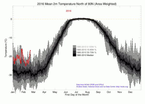
(A
seemingly unstoppable period of record warmth continues for the High
Arctic on February 22nd. Readings for this zone have consistently
remained in the warmest 15 percent of readings on up to record
warmest readings for each day since January 1, 2016. Image
source: NOAA.)
Above
the 80 North Latitude line, departures were even more extreme —
hitting about 13 C or about 23 F warmer than normal for the entire
High Arctic surrounding the North Pole today (see above graphic).
Temperatures that are more typical for late April or early May as we
enter a time of year when this region of the Arctic is usually
experiencing its coldest readings and sea ice extents would normally
continue to build.
Unfortunately,
today’s extreme heat was just an extension of amazing above average
Arctic temperatures experienced there since late December. So what we
are seeing is consistently severe Arctic warmth during a season that
should be Winter, but
that has taken on a character more similar to a typical Arctic
Spring.
Warmth that is now enough to have already propelled the Arctic into
its warmest ever yearly temperatures when considering a count of
below freezing degree days.
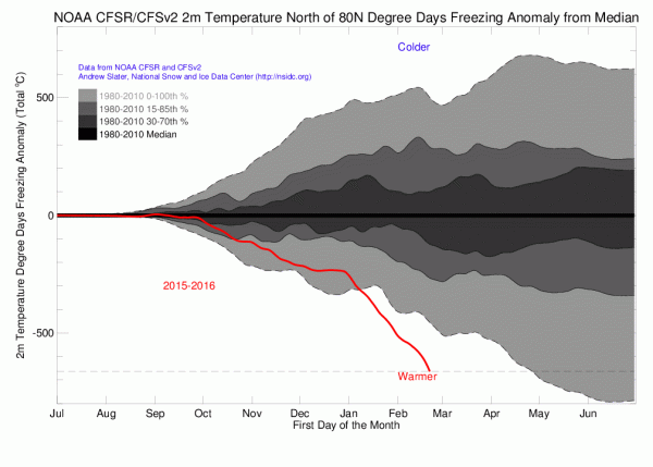
(Degree
Days below Freezing [or Freezing Degree Days, FDD] shows a 670 FDD
departure below that seen during a typical year. If the current trend
continues, the Arctic may see degree days below freezing lag by
between 900 and 1,500 — knocking off about 15 to 25 percent of
below freezing days from a typical Arctic year. Note
that the departure line steepens rapidly after the first major warm
wind event hits the Arctic during late December of 2015 — driving
temperatures above freezing at the North Pole for the first time ever
so late in the year.
Image source: NOAA.)
Freezing
degree-days (FDD) or thawing degree-days (TDD) are defined as
departures of air temperature from 0 degrees Celsius.
The less FDDs during an annual period, the warmer the Arctic has
become. Under the current trend, the Arctic is now on track to hit
between 15 and 25 percent less FDDs than it experiences during a
typical year in 2016.
Looking
at the above graph, what we see is an ongoing period in which Winter
cold has been hollowed out by a series of warm air invasions rising
up from the south. These warm wind events have tended to flow up
through weaknesses in the Jet Stream that have recently begun to form
over the warming Ocean zones of the Bering, Northeast Pacific,
Barents, and Greenland seas. Still more recently, warm wind events
have also propagated northward over Baffin Bay and Western Greenland
— even shoving warm air into the ocean outlets of a typically
frozen Hudson Bay.
Perhaps
more starkly, we find a steepening in the rate of Freezing Degree Day
loss following the freakish series of storms that drove the North
Pole above Freezing during late December of 2015 — the
latest during any year on record that the North Pole has experienced
temperatures exceeding 0 C.
Arctic
Sea Ice Declining Since February 9th
Overall,
a rapid heat uptake by the world ocean system appears to be the
primary current driver of extreme Arctic warming. Atmospheric heat
from greenhouse gas warming swiftly transfers through the ocean
surface and on into the depths. During recent decades,
the world ocean system has taken in heat at a rate equal to the
thermal output of between 4 and 5 Hiroshima-type bombs every
second (with
some individual years hitting a much higher rate of heat uptake).
Since
thousands of meters of warming water insulates better than the land
surface and diaphanous atmosphere, this added heat is distributed
more evenly across the globe in the world ocean system. As such,
ocean warming is a very efficient means of transferring heat to the
Northern Hemisphere Pole in particular. The reason is that the Pole
itself sits atop the warming and globally inter-connected Arctic
Ocean. In addition, the warming surface waters, as noted above,
provide pathways for warm, moist air invasions of the Arctic —
especially during Winter.
For
2016, these kinds of heat transfers not only resulted in an extreme
warming of airs over the Arctic, they have also shoved the Arctic sea
ice into never-before-seen record lows for area and extent.
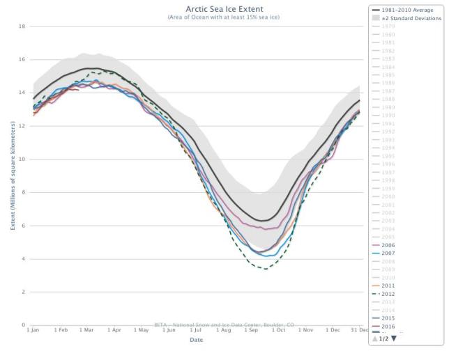
(NSIDC
shows Arctic sea ice entering a new record low extent range from
February 2 through February 21 of 2016. A peak on February 9 and
decline since concordant with record warmth building throughout the
Arctic begs the question — did the sea ice melt season start on
February 9th? Possible — but too early to call for now. Image
source: NSIDC.)
Off
and on throughout January, but more consistently since early February
of 2016, Arctic sea ice has continued to hit new daily record lows.
For Arctic sea ice extent, the record lows entered a streak that has
now been unbroken since February 2nd. By the 21st, extent measures
had hit 14.165 million square kilometers in the National
Snow and Ice Data Center measure.
That’s about 200,000 square kilometers below the previous record
low extent value for the date set during 2006.
Perhaps
more ominously, the current measure appears to have fallen off by
about 50,000 square kilometers from a peak set on February 9th. And
with such extreme heat driving into the Arctic over recent days, it
appears that this departure gap could widen somewhat over the coming
week.
Overall,
radiation balance conditions for the Arctic are starting to change as
well. The long polar night in the Arctic is beginning to recede.
Sunlight is beginning to fall at very low angles over the sea ice,
providing it with another nudge toward melting. Finally, the greatly
withdrawn ice has uncovered more dark ocean surfaces that will, in
turn, absorb more sunlight as the Arctic Winter proceeds on toward
Spring.
With
sea ice declining slightly since February 9, with record warmth
already in place in the Arctic, and with the sun slowly beginning to
provide its own melt pressure, it appears risks are high that we see
a record early start to Arctic melt season. Seven day forecasts do
show high Arctic temperature departures receding a bit from today’s
peak at around 6-7 C above average to between 4 and 5 C above average
by the start of next week. But heat at the ice edge in the Bering,
Barents, Greenland Sea and Baffin Bay are all likely to continue to
apply strong pressure on sea ice extent and area totals. In addition,
recent fracturing within the Beaufort has generated a number of low
albedo zones that will face a wave of unseasonable warmth riding up
over Alaska during the coming days which will tend to slow rates of
refreeze even as Western Alaska’s waters feel the heat pressure of
off and on above freezing temperatures.
So
it appears we may have already begun, in early February a melt season
that will last through mid-to-late September. It’s too early to
make the call conclusively, but the Arctic heat and melt trends
necessary to set up just such an ominous event do appear to be in
place at this time.
Links:
Hat
Tip to Planet in Distress


No comments:
Post a Comment
Note: only a member of this blog may post a comment.