Going,
going...gone are the days (such as at the time of super storm Sandy)
that I could devote time and energy to chronicling the details of
extreme weather events. They are simply too frequent and there are so
many other things that demand my energy, so this report from
Robertscribbler will suffice for now
A Blizzard Roars Out of Climate Change’s Heart — Polar Warming and A Record Hot Atlantic Ocean Brew Up Nightmare Storm for US East Coast
21
January, 2016
There’s
a historic blizzard in the form of Winter Storm Jonas setting its
sights on the US East Coast. The
storm is slowly coming together Thursday evening and now appears to
be set to paralyze a 1,000 mile swath under 1 to 2.5 feet of snow
even as it hurls a substantial storm surge and 40-60 mph winds at
waterfront cities from Norfolk to Boston.
A monster storm whose predicted formation has made headlines since
Tuesday. But what you won’t hear most major news sources mention is
the likelihood that this gathering storm has been dramatically
impacted by a number of new climate features related to a
human-forced warming of the globe.
(Jonas
begins its ocean-heat-fueled rampage on the evening of Thursday,
January 21. Image source: NOAA.)
A
Warming Arctic Shoves the Cold Air Out
To
understand how climate change helped make Jonas so extreme, it’s
best if we start our tale in the Arctic. For if we could mark an area
on the Earth’s surface that is at the very heart of impacts for
human-caused climate change it would be in that zone of the far north
above the 66th parallel. It is there that we see the most dramatic,
most rapid changes — to ice, to weather, to the thawing lands, to
life itself. But unlike what might be said of an American city made
famous by its penchant for sin — what happens in the Arctic doesn’t
stay in the Arctic.
This
is especially true when it comes to weather. If the Arctic cools, it
influences the Jet Stream, strengthens the storm track and shuts more
cold air away in the Arctic. But
if the Arctic warms, as it has more and more frequently during recent
years, then the flood-gates open and cold, Arctic air pours outward —
filling the deep, inevitable dips in the Jet Stream that then
develop.
And
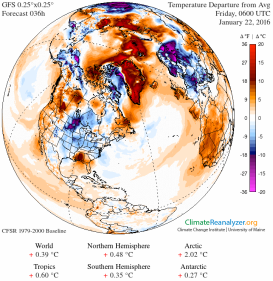
it is a massive accumulation of Arctic heat over the past few weeks
that has forced Arctic temperatures, in places, to rocket to above 36
degrees Fahrenheit (20 degrees C) warmer than average. A heating up
of the entire region to 2-3 degrees Celsius warmer than the already
warmer than average 1979- 2000 baseline. An Arctic warm-up that
muscled out a howling torrent of cold air that then raged on into a
deep trough in the Jet Stream now forming over the eastern half of
the United States.
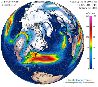
(An
Arctic that is, on average 2.02 C hotter than normal on Friday joins
with a high amplitude wave in the Jet Stream and together drives a
massive flood of cold air into eastern parts of the US on Friday.
Cold air slamming head on into unprecedented heat and moisture
bleeding of the Atlantic Ocean to form the historic weather event
that is now in the pipe. Image source: Climate
Reanalyzer.)
CAPE
— Storms Fueled by Cold Colliding With Hot
In
weather parlance, a trough, or a big dip in the Jet Stream is a storm
generation zone. The reason has to do with the nature of how extreme
differences in temperature and moisture can provide fuel for strong
storms. It’s this very temperature differential that sits as the
cornerstone of our current understanding of how extreme storms are
fueled in terms of Convective
Available Potential Energy (CAPE).
In
the one case, cold air can’t hold as much water in suspension as
warm air. So a big flood of cold air can often fuel major
precipitation events when coming into collision with hot,
moisture-laden air. As hot and cold air are sandwiched closer
together, winds — at both the upper and lower levels — tend to
increase in velocity. The higher the difference in temperature, the
stronger the winds. When these winds run along a big dip in the Jet
Stream — like the one now racing over the US East Coast — they
can spin off twists and vortexes that can rapidly develop into
powerful low pressure systems.
The
lows then feed on the difference in temperatures between the two
sides of the dividing air-mass — cold on the one side, and hot, wet
on the other. The bigger the differential, the more heat and moisture
on one side, and the more cold on the other side, the more potential
that such low pressure centers will develop into monster storms. The
more potential that the storms will develop these crazy atmospheric
sandwiches of hot and cold air that really crank out the extreme
weather.
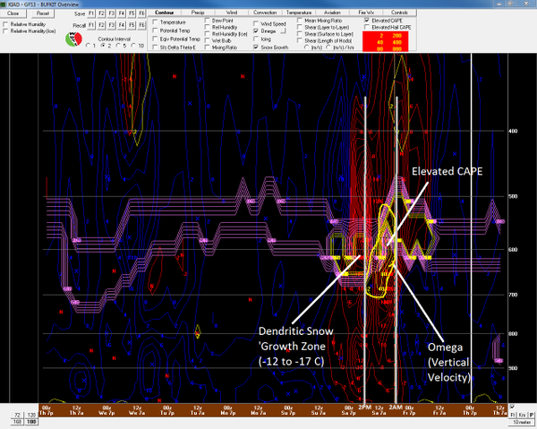
(“Tremendous
Vertical Motion.” Anthony Sagliani tweets about extreme CAPE for a
blizzard zeroing in on the US East Coast. What’s important to
mention is that human-forced climate change has CAPE written all over
it. Image source: Anthony
Sagliani.)
In
terms of the current storm, some of the CAPE potentials coming in are
just off the charts. The above graphic, posted in this
recent tweet by Anthony Sagliani,
identifies the potential for 5 inch per hour thundersnow at Dulles
International Airport (AID) between 2 AM and 2 PM Saturday. To be
very clear, a 1 inch per hour snowfall was once considered an extreme
event. Now we are looking at possibly 5!
A
Record Hot Atlantic Feeds it All
In
the context of human-driven climate change, this is one of the
reasons why our warming up of the world can generate extreme weather.
It warms the Earth unevenly. It puts cold next to hot by driving cold
out of the polar zones and by warming up huge areas of land and
ocean. And it dumps more moisture into the atmosphere through an
amplified evaporation from these greatly warmed Earth surfaces. Mix
it all together and you get Anthony Sagliani’s ‘tremendous
vertical motion.’
How
does this work? In two words — latent heat. More specifically the
convective heat energy available in water vapor. And where does most
of that latent heat energy come from? It comes, for the most part, in
the form of warm waters evaporating into the air above the world’s
oceans. More specifically to our current storm it comes in the form
of record warm to near record warm temperatures in the waters of the
Gulf Stream off the US East Coast (See
Dr Jeff Master’s ‘The Future of Intense Winter Storms”).
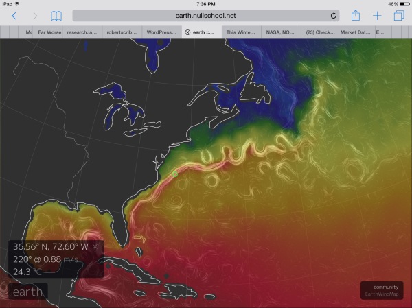
(Sea
surface temperatures off the US East Coast are more comparable to
those seen during Summer than what would be typical for January. A 76
degree sea surface off Norfolk will provide a massive amount of heat
and moisture to fuel the new kind of storm that is Jonas. Image
source: Earth
Nullschool.)
As
Dr. Michael Mann noted in a tweet earlier this week, sea
surface temperatures off the US East Coast are extraordinarily warm
for this time of year.
And Bill McKibben was absolutely astute in saying that these near
record temperatures “should
turbo-charge this weekend’s blizzard.”
And
they’re absolutely ridiculously warm — in the range of 76 degrees
Fahrenheit in a region about 150 miles due east of Norfolk, Virginia.
A region of ocean over which the developing storm center will
directly cross. An area of water that is now in the range of 7
degrees Celsius above average (13 degrees Fahrenheit). For the ocean
surface, this is screaming hot — more typical to summer than
anything one would expect to see in January, even in the Gulf Stream.
You
just don’t see these kinds of temperature departures for the ocean
— or at least you didn’t before human-caused climate change
started to ramp up. But now we have them — an ocean surface hot
enough to support a hurricane but one that will this weekend provide
fuel for a blizzard. So the kind of blizzard we will have will not at
all be like even the usual blizzards of the 20th Century. This is the
new, worse variety that will sadly become more frequent. Destructive,
heavy snowfall in the 4-5 inches per hour range, thundersnow and
storm surges combined, swaths of hundreds of miles impacted and
crippled. The kind for the new age of a human-heated atmosphere —
destabilized to produce freak storms of a ferocity and frequency the
likes of which we have never seen.
UPDATE
— Snowfall Begins With Some Models Showing 4 Feet or More Possible
(Average Guidance For Gaithersburg is 24-30 Inches)
Moderate
snowfall began at 1:35 PM on Friday in my hometown of Gaithersburg,
MD. Model guidance for our area is in the range of 24-30 inches,
with as
much as 4 feet coming up in some of the GFS ensembles.
Will
be posting videos and related updates every 2-3 hours as conditions
change.
UPDATE:
1-2 Inches on the Ground at Gaithersburg, MD as of 3:42 PM
Wind
and rates of snowfall have picked up somewhat over the past two
hours. As of 3:42 PM, about 1-2 inches had fallen and the wind was
visibly swaying some of the tree branches outside. Reports are coming
in from regions to the south of a very heavy band of snow that should
arrive in our area by later this evening.
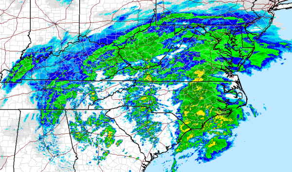
Radar
captures by the National Weather Service indicate this band setting
up over much of Central and Eastern North Carolina — stretching
northward through just west of Richmond. GFS model tracking and
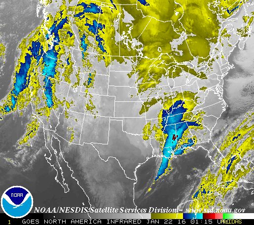
satellite confirmation indicate a coastal low developing in the
region of Northern South Carolina. This low is beginning to transfer
Atlantic moisture into the storm — pulling strong winds off that
abnormally warm region of ocean just east of Norfolk and into the
developing powerful snowfall and.
Sustained
winds along the coast are now approaching gale force. We should
expect these winds to rapidly increase over the afternoon and evening
hours even as the moisture feed and rate of snowfall intensifies.
Links:
Hat
Tip to DT Lange
Hat
tip to Colorado Bob
Here is live coverage from the Guardian
- Washington DC in bull’s eye of potentially record-breaking storm
- Hundreds of vehicle crashes reported as storm moves through south
- Coastal flood warnings and states of emergency in effect


No comments:
Post a Comment
Note: only a member of this blog may post a comment.