Polar Amplification vs a Godzilla El Nino — Is the Pacific Storm Track Being Shoved North by Arctic Warming?
27
January, 2016
It’s
an El Nino year. One of the top three strongest El Ninos on record.
The strongest by some NOAA measures. And we are certainly feeling its
effects all over the world. From severe droughts in Southeast Asia,
Africa, and South America, to Flooding in the Central and Eastern US,
Southern Brazil, and India, these impacts, this year and last, have
been extreme and wide-ranging. During recent days, Peru
and Chile saw enormous ocean waves and high tides swamping
coastlines.
Record flooding and wave height events for some regions. All impacts
related to both this powerful El Nino and the overall influence of
human-forced warming by more than 1 C above 1880s temperatures on the
whole of the hydrological cycle.
Amped
up by a global warming related 7 percent increase in atmospheric
water vapor (and a related increase in evaporation and precipitation
over the Earth’s surface), many of these El Nino related impacts
have followed a roughly expected pattern (you
can learn more about typical El Nino patterns and links to climate
change related forcings in this excellent video by Dr Kevin Trenberth
here).
However, so far, some of the predicted kinds of events you’d
typically see during a strong El Nino have not yet emerged. A
circumstance that may also be related to the ongoing human-forced
warming of the globe.
Storm
Track Not Making it Far Enough South
Particularly,
there has been an absence of powerful storms running in over Southern
California then surging on into Arizona, New Mexico and West Texas.
During strong El Nino events, heat and moisture bleeding off the
super-warmed Equator have typically fed powerful storms racing across
the Pacific. These storms have tended to engulf the entire US Pacific
Coast from San Diego through to Seattle. However, much of the storm
energy is often directed further south toward Central and Southern
California.
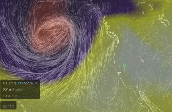
(A
massive Pacific storm being warded off by high pressure systems over
the US West Coast on Tuesday, January 26th. Image source: Earth
Nullschool.)
These
storms tend to run over regions that are typically much drier. So
strong El Ninos of the past have often generated abnormal and
memorable storms and rains. But this year there has been, mostly, an
abscense of such events. Storms have slammed into Northern
California, Oregon, been deflected back into the coasts of Canada and
Alaska, or even been bottled up near the Aleutian Island Chain.
But
today, a high pressure cell dominates the western US, warding off a
powerful storm system. The storm, howling just south of Alaska and
pushing out average 60 foot wave heights and hurricane force winds
across the Pacific, is predicted to rebound toward Alaska where it
will become bottled up in the Bering sea and push above freezing
temperatures into the Arctic Beaufort Sea during Winter. The storms
and rains will steer far away from Southern California and even much
of California altogether.
Rainfall
Patterns Have Tended Toward the North, Contrary to NOAA’s Seasonal
Predictions
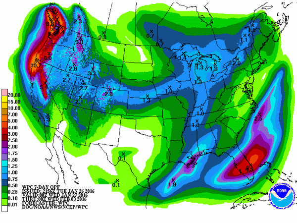
(NOAA
precipitation quantities prediction for the coming week is indicative
a continued northward shift of the Pacific Storm track. Image
source: NOAA.)
It’s
a pattern more reminiscent of some strange ridiculously resilient
ridge (RRR) than that of a strong El Nino. And though storms later
this week are again predicted to slam into the Northwest and weekly
rainfall totals are expected to rise to near 1 inch for parts of
Southern California, the path of these storms and related moisture
flows are quite a bit further north than one would expect for a year
in which strong El Nino was the dominant feature.
The
moisture flow, instead, so far has tended northward across the upper
and central tiers of the US even as the El Nino related moisture
bleed toward the Gulf and East Coasts has remained quite intense.
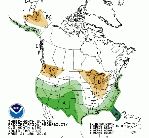
Such observed weather is both contrary to what we’ve tended to know
about Strong El Nino and to NOAA’s seasonal forecasts which had
predicted much more rain for the southwest than what we’ve seen so
far.
(NOAA
three month outlook is more in line with traditional strong El Nino
forecasts bringing strong storms in through the southwestern US. We
currently do not see a prevalence of that particular pattern. Image
source: NOAA’s
Climate Prediction Center.)
Polar
Warming + Hot Blob Tugging the Storm Track Northward?
Since
weather patterns related to El Nino are an aspect of global
atmospheric dynamics — teleconnections between the influence of an
excess of hot air and heavy rainfall at the Equator and of large
scale atmospheric wave patterns downstream, you have to wonder if
there isn’t some kind of influence competing with El Nino on a
global scale. One with enough oomph to nudge the Pacific Storm Track
northward.
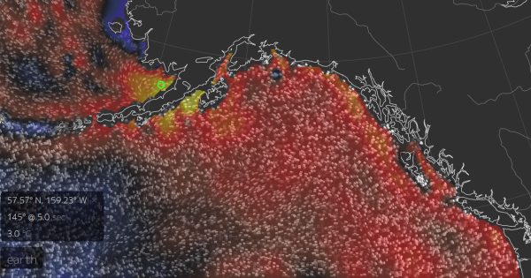
(The
Hot Blob is still a dominant feature of ocean waters in the Pacific
Northwest. Is its influence helping to pull the Pacific Storm Track
northward during a strong El Nino year? Image source: Earth
Nullschool.)
The
first likely suspect is the pool of still much warmer than normal sea
surface temperatures lurking off the US West Coast. Though somewhat
diminished from their peak during 2014 and 2015, the waters in the
hot blob off California, Oregon, Washington, Canada and Alaska are
still in the range of 1 to 3 C above average. A very large region of
significantly warmer than normal ocean surfaces that wasn’t present
during the 1982-83 and 1997-1998 super El Ninos. And much of the
warmest anomalies are now centered much further to the north along
the coast of Alaska.
But
the second potential player is likely even more significant. And that
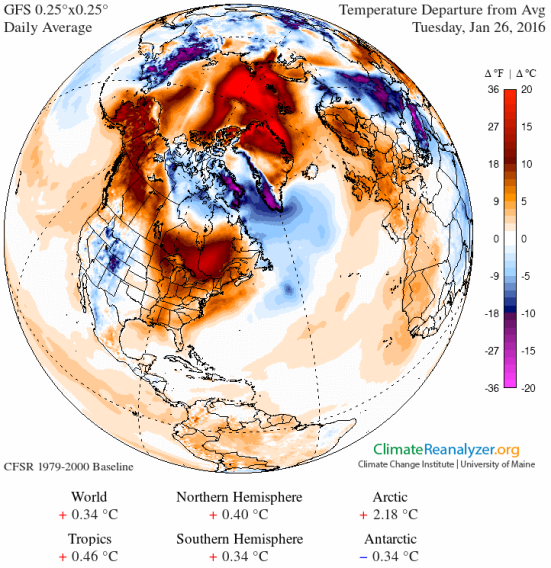
would be an ongoing and extreme warming of the northern polar region.
Heating at the Pole generates less thermal gradient between the
higher Latitudes and the Equator. And such a lessened gradient would
tend to impact the strength of the circumpolar winds that drive
weather systems and storm tracks. In particular, the overall warming
of the globe would tend to pull these storm tracks northward even as
the loss of thermal gradient would tend to enhance wave patterns in
the Jet Stream.
(Polar
Amplification shown as very intense in the January 26 Climate
Reanalyzer graphic. Is Polar Amplification helping to shove the
Pacific Storm Track northward even during a record strong El Nino
year? If so, it’s bad news for long term moisture levels in the US
Southwest. Image source: Climate
Reanalyzer.)
Perhaps
also specifically related to this ongoing polar amplification, we
find that two warm slots — one over the Barents and far North
Atlantic east of Greenland and another over the Bering — have
tended to develop during recent Winter years. These slots have often
served as staging areas for warm air invasions of the Arctic. But
what they also represent are regions of water that have been freshly
liberated from their sea ice coverings. As such, these vast regions
of water serve as heat transport and ventilation zones. And all this
extra heat energy may be sucking the related North Atlantic and North
Pacific Storm tracks into what may well be described as an oceanic
and atmospheric trap.
If
such a situation where the case, we’d tend to see a dipole of warm
east, cold west in the storm trap regions. And that’s exactly what
we’ve seen more and more of with Greenland and Siberia serving as
the backdrops to reinforce this tendency. Thus setting up the stage
for cold air slots cutting through Northeast Siberia and Northeast
Canada and warm, wet air slots over Alaska and the UK.
The
question to be asked is, then, are these new influences related to
human-forced warming also now doing battle with El Nino for control
over the Pacific Storm Track? And has that influence increased enough
to dramatically nudge that track northward? We may find the answer to
that question in what happens to the direction of powerful Pacific
Storms over the next few months. But early indications seem to be
that polar warming and the related hot blob may have thrown a wrench
in the kinds of El Nino storms that we’ve been used to.
Links:
Hat
Tip to Colorado Bob
Hat
Tip to DT Lange
Hat
Tip to Andy in San Diego
No comments:
Post a Comment
Note: only a member of this blog may post a comment.