Fire danger and heat for Vic, Australia yet again!!!
Fire Weather Warninfor the Mallee, Wimmera, Northern Country, North Central, South West and Central forecast districts
Issued at 4:11 pm EDT on Monday 18 January 2016.
Weather Situation
A hot and dry day with moderate to fresh northwesterly winds over inland western and central parts of the State ahead of a milder southwesterly change extending from the southwest in the afternoon and evening. Mild sea breezes about coastal parts from mid-morning extending slowly inland during the day.
For Tuesday 19 January:
Severe Fire Danger is forecast for the following forecast districts:
Mallee, Wimmera, Northern Country, North Central, South West and Central
The CFA advises that you:
Action your Bushfire Survival Plan now.
Monitor the fire and weather situation through your local radio station, www.cfa.vic.gov.au
Call 000 (Triple Zero) in an emergency.
For information on preparing for bushfires go towww.cfa.vic.gov.au.
Summer
thunderstorms roll in
Share on Reddit
Share on Linked In
Shar via email
New
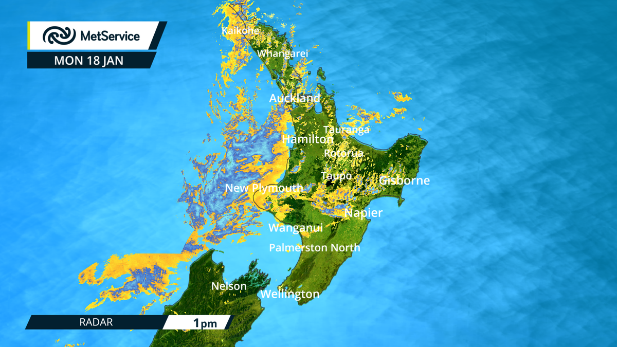
Zealand's summer is turning wet and stormy again, with much of the
country in for downpours and, from Marlborough north, at risk of
thunderstorms
Parts
of Marlborough have already had a drenching and MetService is warning
of more downpours in Nelson and Marlborough, Taranaki, parts of Bay
of Plenty and the central North Island high country.
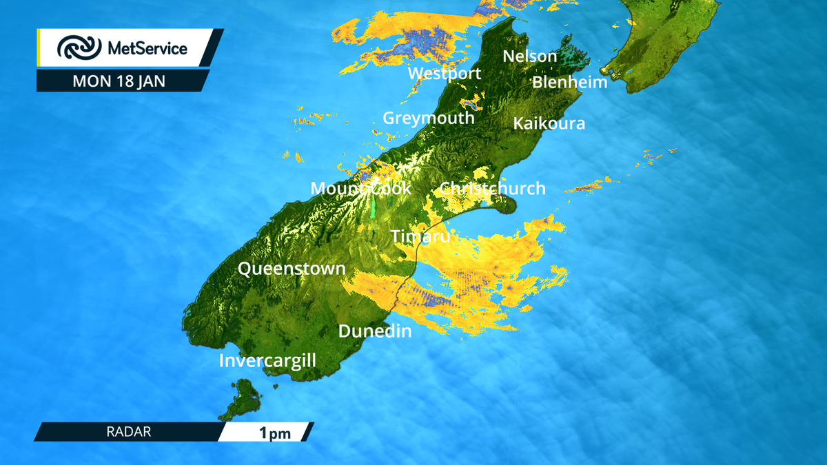
Radar is busy, scattered rain in Auckland, still falling Nelson, Westland & Canterbury http://bit.ly/NZRainRadar
^CL
Thunderstorms
are likely over the northwestern half of the North Island, and
northwest Nelson and from Taranaki to western Coromandel Peninsula
northwa
The
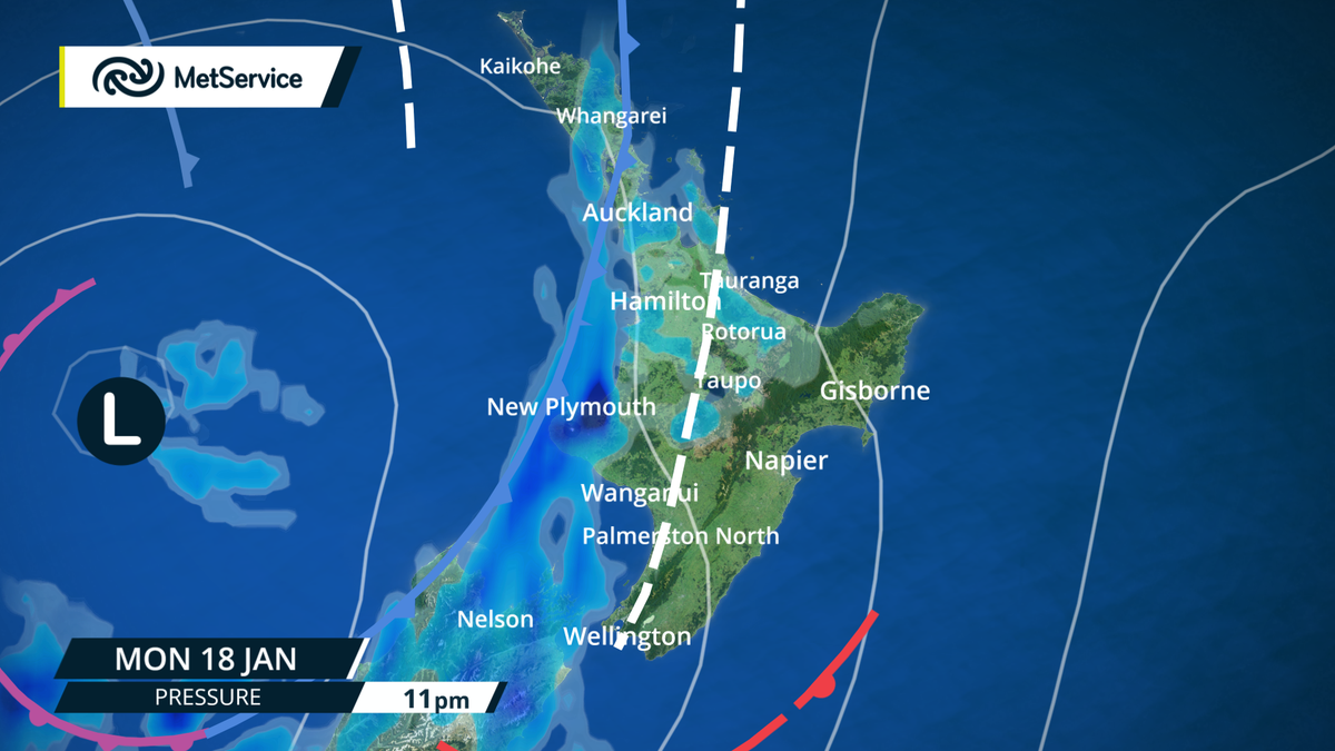
forecaster said a very humid northerly flow was being pushed ahead of
a low pressure system that was expected to move across the country
today and Tuesday.
In
Nelson, Marlborough and Taranaki, 100-180mm of rain was likely in a
12-15 hour period. Holidaymakers were being warned not to camp near
rivers and streams, which could rise rapidly overnight.
Further
south the rain is bringing relief for North Canterbury farmers
battling the drought. The MetService said most of the the region had
had between 10-20mm of rain over the last few days.
High risk of heavy falls with some thunder, evening & overnight in #Auckland http://metservice.com/towns-cities/auckland/auckland-central …
^CL #AKL
A
short period of intense rain, with possible thunderstorms, was
expected at western Bay of Plenty and Rotorua, with 50-80mm likely
over a 4-6 hour period.
Emergency
management staff in the Nelson region are warning residents and
visitors to brace themselves for a downpour today, with 100-150mm
likely to accumulate in the ranges around the city to 3am Tuesday,
while 70-90mm was likely in lower lying areas.
Maximum
rainfall intensities of 25-35mm an hour are forecast from this
evening in isolated thunderstorms around the region.
Nelson
Tasman Civil Defence and Emergency Management spokesperson Paul
Shattock warned rivers and streams were likely to rise rapidly, and
people camping near waterways had to be on guard.
"A
major concern that we do have is anyone ... (such as freedom campers)
who may be parked up beside the river... might get a bit of a shock
if they're not aware." Mr Shattock said Nelson city itself would
also "probably cop some" and the worst dump of rain was
expected late tonight.
Police
in Whangarei are warning motorists to take extra care in wet weather
after two serious crashes south of the city in the past week.
A
vehicle lost control on State Highway 1 at Smeatons Hill this morning
and collided with a northbound car leaving both drivers with moderate
injuries.
A
police spokesperson said oil and diesel rose to the surface on hot
days, so when mixed with rain water the roads became very slippery.
Last
week a 45-year-old died when his vehicle crossed the centre line and
collided with a logging truck in the same area.
Airlines move to clear backlog due to fog
In
Wellington, flights in and out of the city resumed
this morning after fog caused massive disruption yesterday.
Jetstar
said it expected to clear the backlog from fog delays at Wellington
airport by tomorrow afternoon.
Jetstar
spokesperson Phil Boeyen said about 1300 passengers were affected,
with eight flights cancelled and one international flight diverted to
Auckland.
He
said normal services resumed this morning, with three additional
flights put on to help clear the backlog.
Air
New Zealand estimates about 60 flights and almost 3000 passengers
were affected.
But
it said there was no way of knowing the size of the backlog because
many customers had requested refunds, taken credit or rebooked
flights.
MetService
said fog on Wellington's south coast could affect the airport
brieftly but a north easterly wind expected later this evening,
should push it out to sea.

 MetService


No comments:
Post a Comment
Note: only a member of this blog may post a comment.