Blizzard Fueled By Ocean Heat Cripples Eastern US, Floods Coast With Historic Storm Surge

23
January, 2016
We
knew the weather this weekend would be wicked. A
predicted extreme winter storm kicked into a much higher gear by an
atmosphere warmed by human greenhouse gas emissions and by a record
heat and moisture bleed coming off an anomalously hot Atlantic Ocean
kind of wicked.
A severe Blizzard featuring 12-40 inch snows, near record to record
storm surges, and hurricane force wind gusts that has been showing up
in model forecasts since earlier this week. And it appears that’s
exactly what we’re getting.
Heavy
Snows Cause Major Disruptions
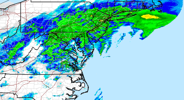
(National
Weather Service Radar showing
heavy snowfall stretching from West Virginia to Rhode Island at 10:45
AM Saturday Morning.)
By
early Saturday morning, the reports were coming in. More
than 1,500 vehicles were wrecked or disabled along Virgina State
highways Friday evening as the storm roared across the region.
Sudden, heavy
snowfall generated a similar snarl — setting off a 40 mile long
traffic jam in Kentucky which stranded motorists for more than 12
hours.
According to reports from The
Weather Channel,
Jonas had already dumped as much as 28 inches of snow by 8 AM this
morning. With 5-20 more inches on the way for many regions, these
totals are expected to continue to climb.
These
crippling snowfall totals were hitting very close to home in
Gaithersburg, MD — where I took this video of still heavy snows
over an already amazing 21 inch accumulation (unofficial).
The video was taken during a lull in an area that’s been experiencing accumulations at faster than 1 inch per hour rates since late last night. Sporadic reports of thundersnow were also starting to trickle in — especially in areas closer to the Chesapeake Bay like Baltimore
The video was taken during a lull in an area that’s been experiencing accumulations at faster than 1 inch per hour rates since late last night. Sporadic reports of thundersnow were also starting to trickle in — especially in areas closer to the Chesapeake Bay like Baltimore
Severe Coastal Flooding Threat Grows
Along
the coast, Jonas’s impacts began to look more like those of
Superstorm Sandy than of a typical winter snowmaker. Winds on the
Eastern Shore of Virginia hit a peak hurricane force gust of 85 miles
per hour earlier this morning as Jonas gorged on record warm Atlantic
Ocean waters and intensified. These strong winds combined with
astronomical high tides and a climate change related pile up of Gulf
Stream waters off the US East Coast to push tides to the second
highest level on record for Delaware beaches.
On Saturday morning, the water level at Lewes, Delaware, rose to 9.27 feet, a storm surge of more than 4 feet. This is the highest level on record at that gauge, beating 9.20 feet on March 6, 1962. Record flooding has also been observed in at least three New Jersey locations (Great Channel at Stone Harbor, Cape May Harbor, Delaware Bay at Cape May).
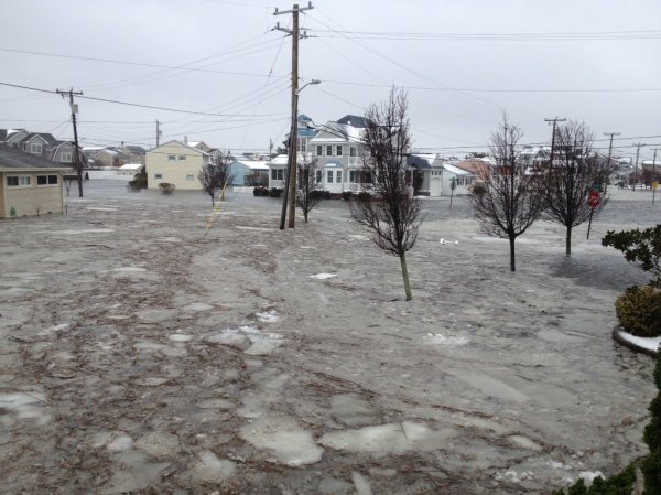
Cindy
Nevitt in
Cape May, New Jersey sent along this photo of ocean floodwaters and
ice floes surging around her coastal home this morning as Jonas
mercilessly drove its surge inland:
(Severe
coastal flooding surges into Cape May New Jersey as hurricane force
gusts drive a storm surge into the Northeast Coast on Saturday
morning. Image source: Cindy
Nevitt.)
Reports
are beginning to come in of ongoing emergency evacuations of coastal
homes flooded by surging waters in this region. Given the 9 foot
above normal tides combined with hurricane force wind gusts and 30
foot waves slamming into beaches, sand dunes and sea walls, it’s a
situation that is, sadly, likely to worsen as the day progresses.
Many
of the Worst Impacts Still to Come
To
this point, it’s important to note that, with Jonas still centered
off the Delmarva Peninsula, this major tidal flooding that regions
are now currently experiencing is just the start. The head of water
should continue to build on into late Saturday as it moves up the
coastline and into New York City, Long Island, Coastal Connecticut,
Rhode Island and Massachusetts. Furthermore, impacts to New Jersey
and Delaware should remain dangerous or worsen over the coming hours
as winds pile waves and waters on top of already record high tides.
Meanwhile,
Jonas will continue to generate heavy snowfall over hundreds of miles
on into Saturday evening. The situation, therefore, remains quite
dangerous and all residents in the affected areas should keep tuned
to local emergency officials for instruction. In other words, this
climate change enhanced monster winter storm isn’t done yet. Not by
a long shot.
Links:
Hat
Tip to DT Lange
Hat
Tip to Colorado Bob
Hat
Tip to Greg


No comments:
Post a Comment
Note: only a member of this blog may post a comment.