Warm Arctic Storm To Hurl Hurricane Force Winds at UK and Iceland, Push Temps to 72+ Degrees (F) Above Normal at North Pole
27
December, 2015
We’ve
probably never seen weather like what’s being predicted for a vast
region stretching from the North Atlantic to the North Pole and on
into the broader Arctic this coming week. But it’s all in the
forecast — an Icelandic low that’s stronger than most hurricanes
featuring a wind field stretching over hundreds and hundreds of
miles. One that taps warm tropical air and hurls it all the way to
the North Pole and beyond during Winter time. And it all just reeks
of a human-forced warming of the Earth’s climate…
Freak
North Atlantic Storm Featuring Extremely Low Pressures
Today,
a powerful, hurricane force low pressure system is in the process of
rounding the southern tip of Greenland. This burly 960 mb beast
roared out of an increasingly unstable Baffin Bay on Christmas. As it
rounded Greenland and entered the North Atlantic, it pulled behind it
a thousand-mile-wide gale force wind field even as it lashed the tip
of Greenland with Hurricane force gusts. To its east, the storm now
links with three other lows. Lows that are, even now, drawing
south-to-north winds up from a region just west of Gibraltar, on past
the UK, up beyond Iceland, over Svalbard, and into the Arctic Ocean
itself.
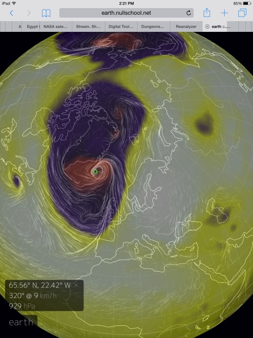
(GFS
forecasts predict a storm bombing out between 920 and 930 mb over
Iceland by Wednesday. It’s a storm that could rival some of the
strongest such systems ever recorded for the North Atlantic. But this
storm’s influence is unique in its potential to shove an
unprecedented amount of warm air into the Arctic. A warm storm for
the Arctic Winter time. Image source: Earth
Nullschool.)
Over
the next few days these three lows are predicted to combine into a
storm the likes of which the far North Atlantic rarely ever sees.
This storm is expected to center over Iceland. But it will have
far-reaching impacts ranging from the UK and on north to the pole
itself. As the lows combine, GFS predicts them to bomb out into an
unprecedentedly deep low featuring 920 to 930 mb (and possibly lower)
minimum central pressures by this coming Wednesday. These
pressures are comparable to the very extreme storm systems that raged
through the North Atlantic during the Winter of 2013. Systems that
featured minimum pressures in the range of 928 to 930 mb.
It’s
worth noting that the lowest pressure ever recorded for the North
Atlantic occurred in the much further southward forming Hurricane
Wilma at 882 mb. In
the far north, a January 11 1993 storm between Iceland and Scotland
featured 913-915 mb pressures.
It’s worth noting that the GFS model currently puts the predicted
storm within striking distance of setting a new record for the far
north. Meanwhile,
ECMWF models predict a somewhat less extreme low in the range of 940
mb.
By comparison, Hurricane Sandy bottomed out at around 940 mb as well.
Regardless
of peak strength, the expected storm is predicted to be both very
intense and wide-ranging as both model forecasts feature numerous
lows linked in chain with a much deeper storm center near Iceland.
Among these and further north, two more strong lows in the range of
965 to 975 mb will round out this daisy chain of what is now shaping
up to be a truly extreme storm system. The Icelandic coast and near
off-shore regions are expected to see heavy precipitation hurled over
the island by 90 to 100 mile per hour or stronger winds raging out of
35-40 foot seas. Meanwhile, the UK will find itself in the grips of
an extraordinarily strong southerly gale running over the backs of 30
foot swells.
Warm
Winds to Force Above Freezing Temperatures For the North Pole
(By
early Wednesday, temperatures at the North Pole are expected to
exceed 1 degree Celsius readings. Such temperatures are in the range
of more than 40 degrees Celsius (72 degrees Fahrenheit) above
average. Image source: Earth
Nullschool.)
All
along the eastern side of this storm, powerful warm winds are
expected to funnel northward. Originating along the 35 degree North
Latitude line west of Spain, these winds will force a train of warm
air and moisture pole-ward ahead of our storm. The winds will rush up
over a very riled North Sea, they will howl into a far warmer than
normal Barents, and they will roar on past Svalbard — finally
turning as they pass beyond the North Pole.
These
winds will bring with them extraordinarily warm temperatures for the
High Arctic region during Winter time. By Wednesday, the North Pole
is expected to see temperatures in the range of 1-2 degrees Celsius
or 41-42 degrees C above average (73-75 degrees Fahrenheit above the
normal daily temperature of -40 F for a typical Winter day). Such an
extreme departure would be like seeing a 120 degree (Fahrenheit)
December day in my hometown of Gaithersburg, MD. Needless to say, a
1-2 C reading at the North Pole during late December is about as odd
as witnessing Hell freezing over. But, in this case, the latest wave
of warmth issuing from a human-driven shift toward climatological
hell appears to be on schedule to arrive at the North Pole in just a
few more days.
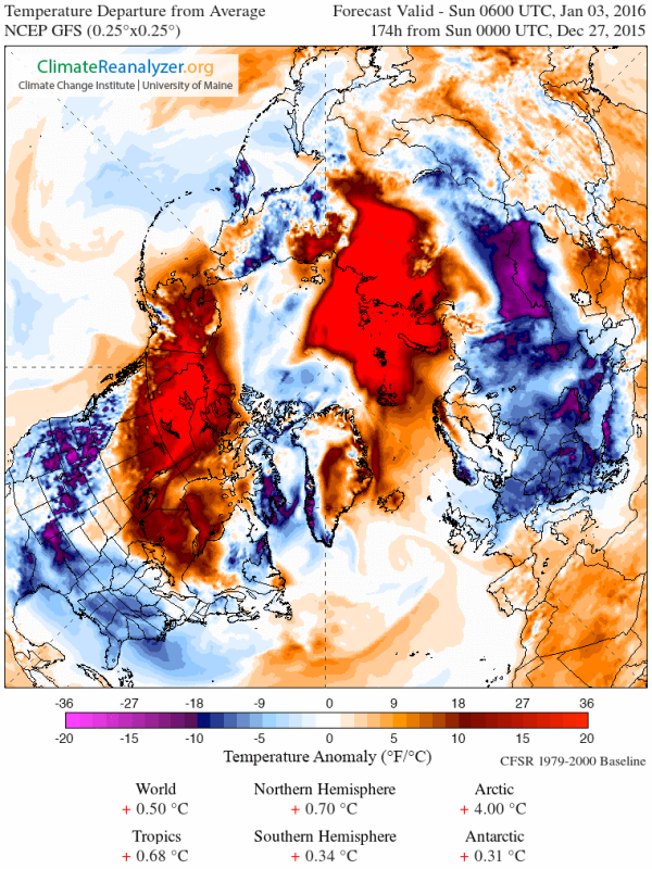
(The
Arctic region as a whole is expected to experience a [frankly quite
insane] temperature anomaly in the range of 4 degrees Celsius above
average by January 3rd of 2016. Note the broad regions over Northern
Canada, Siberia, and the Arctic Ocean that are predicted to
experience temperatures in the range of 20 degrees Celsius above the
already hotter than normal 1979 to 2000 baseline readings. For some
areas — particularly in Northern Canada — this will mean near or
even above freezing temperatures for tundra and permafrost zones in
the depths of Winter. A set of conditions that has serious
implications for permafrost thaw and related carbon store feedbacks.
Image source: Climate
Reanalyzer.)
New
Freakish Weather Patterns Concordant With Human-Forced Climate Change
The
deep, northward-driving synoptic pattern associated with both
powerful high Latitude storms and warm winds is only something we’ve
begun to see during recent years. The
warming polar environment itself generates weaknesses in the Jet
Stream which tends to allow these warm air invasions.
In addition the warming oceans — which hold heat for longer than
land masses — generate pathways for warm air invasions of the
Arctic during Winter time. The Barents Sea, for example, has been
particularly warm during recent years which has resulted in numerous
warm wind invasion events issuing northward over Svalbard and regions
eastward during recent years.
A
final ingredient to this highly altered weather pattern appears to be
a cooling of the sea surface in the North Atlantic just south of
Greenland. This cooling has been set off by an increase in fresh
water melt outflows from Greenland as glacial melt there has
accelerated concordant with human-forced warming. The cool pool of
glacial melt water south of Greenland has aided in the generation of
a dipole featuring cool air to the west, warm air to the east. This
year, warm air has tended to flow northward over Spain, the UK, and
along a region between Iceland and Scandinavia. During the Winter of
2015-2016, this warm air slot has also been the breeding ground for
very unstable weather and a number of powerful storm systems.
(It’s
an El Nino year. But despite a climate feature that would typically
strengthen the Jet Stream, what we see is another Arctic warm air
invasion reminiscent of the recent polar vortex collapse events of
Winters 2012 through 2014-2015. Note that the region of coldest air,
which would typically tend to center over the North Pole has been
driven south toward Greenland and Baffin Bay. A pattern that we’d
expect concordant with world ocean warming and Greenland melt as a
result of human-forced climate change. Image source: ECMWF.)
Unfortunately,
this larger overall pattern marks a progression away from typical
North Atlantic weather and toward a much more stormy environment.
It’s an environment that is all too likely to be marked by features
of warm air invasions moving up through the Barents and into the High
Arctic during Winter. Of the Northern Hemisphere storm circulation
tending to wrap around Greenland as the center of cold air shifts
from the North Pole to the last bastion of dense glacial ice. And
of a very unstable storm generating cold water and surface air
temperature zone deepening and gaining an ever-stronger hold within
the North Atlantic.
These
are influences we see now. Ones that are impacting both the current
powerful storm over Iceland and the unprecedented surge of warm air
that is now preparing to invade the High Arctic. And though El Nino
likely also played a part in the shifting of the storm generation
zone toward Iceland, the far northward propagation of warm air into
the Barents and High Arctic along with the extreme strength of the
predicted storm are both likely new features of an overall altered
pattern. What we witness here are both climates and weather features
changing before our eyes in the form of what to us may seem a freak
event — but what is actually part of a dangerous transition period
away from the stable climates of the Holocene.
Links:
Hat
Tip to DT Lange
Hat
Tip to Colorado Bob (Remember — “Hot seeks Cold.”)


No comments:
Post a Comment
Note: only a member of this blog may post a comment.