Climate Change Superstorm Redux? Joaquin Shows Some Eerie Similarities to Sandy in Forecast.
30
September, 2015
It’s
an El Nino year. So that’s supposed to mean a quiet Atlantic
Hurricane Season, right? But as the tenth storm of 2015 threatens
intensification, very heavy rains, and broadening wind fields as it’s
expected to cloak itself in a frontal storm along a track similar to
Sandy — it appears a climate-changed riled ocean and atmospheric
system have failed to get the message.
Anyone
looking at today’s ocean-atmospheric conditions and the Global
Forecast System model run predictions probably couldn’t shake off
the shivers as a number of chilling similarities to Superstorm Sandy
began to show up in the five day outlook. The forecast is very, very
uncertain. But it appears we might have a developing Superstorm-like
Joaquin on our hands.
“There is going to be catastrophic flooding from North Carolina to Massachusetts, and this is going to disrupt the economy regardless of whether or not Hurricane Joaquin makes landfall.”
All
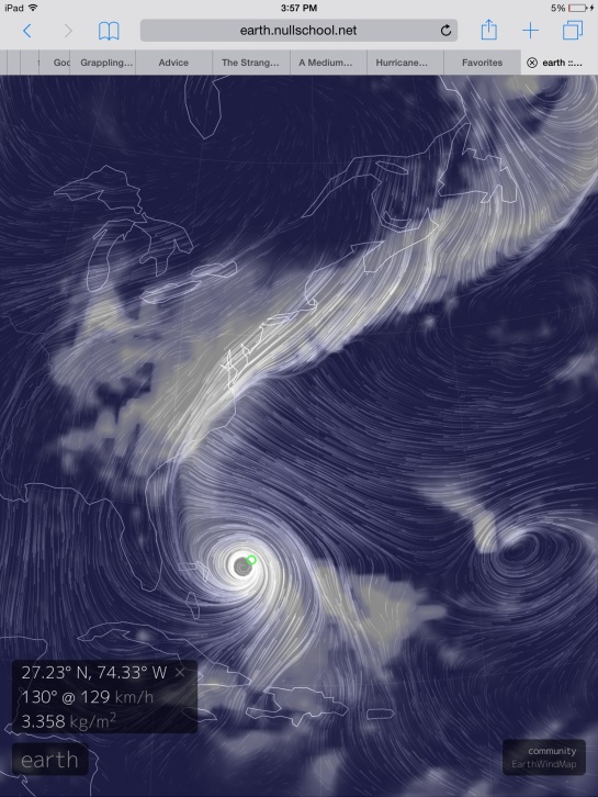
Eyes on Joaquin As Climate Change Pattern Dominates North Atlantic
(GFS
water vapor and wind forecast for October 2 shows a category 2-3
Jaoquine interacting with a powerful trough stretching down across
the US East Coast. A trough extending all the way from Norway. Though
not a polar trough like the one that interacted with Sandy, and
though Joaquin’s characteristics aren’t as likely to go
extra-tropical like Sandy, the broadening wind field, the potential
left turn and the superstorm combining of trough and hurricane are
potentially similar features. Image source: Earth
Nullschool.)
A
freakish ‘Storms
of My Grandchildren‘
type cool pool dominates the northern Atlantic. The backed-up Gulf
Stream off the US East Coast is super hot (1-6 degrees Celsius above
average). A massive trough is digging in — telegraphing from Norway
through Iceland on to Southern Greenland, extending yet southwest
over Newfoundland and the Northeastern and Mid Atlantic US. Further
south, a developing Hurricane Joaquin over the Bahamas is about to
shake hands with this massive trough. Just south of Newfoundland, a
blocking high pressure system appears ready to bar Joaquin’s
passage to the north and east. Setting up the potential for Joaquin
to embed in the trough, to develop a rapidly expanding wind field
even as it strengthens, and to possibly make a sickening left turn
into the US East Coast.
Sound
familiar? If so, it’s
because you heard a similar story back during late October of 2012.
Jaoquin
Forecast — Very Stormy Five Days for US East Coast
Currently,
Jaoquine is a strengthening category category 1 hurricane packing 85
mile per hour winds as it drifts toward the southwest near the
eastern Bahamas. Over the next two days Jaoquin
is expected to strengthen, possibly into a major hurricane, even as
it begins to track toward the north and west.
This track will result in its interacting with the large trough
mentioned above. Even if Jaoquine does not make landfall, its
interaction with the trough is expected to dump substantial and
torrential amounts of rainfall from North Carolina on through New
England even as it drives a broad tropical storm force wind field and
related storm surge onto shore.
(NOAA
five day rainfall forecast shows potential for significant related
flooding for the Eastern Seaboard. Image source NOAA
CPC.)
According
to NOAA forecasts, 5 day rainfall totals are now expected to exceed 7
inches throughout large sections of North Carolina, Virginia,
Delaware, New Jersey and Maryland with measures in excess of 5 inches
expected from South Carolina all the way to Nantucket.
Joaquin’s
wind field is also expected to expand as it interacts with both the
trough and large circulation of the blocking high to the north and
east. This broad wind field will bring at least strong nor-easter
like conditions to the US East Coast. But the broad clockwise
circulation off the blocking high also heightens risks that Joaquine
will be shoved into the East Coast even as it strengthens.
Current
model runs bring
a powerful category 1-3 Joaquine, packing a broad wind field with
maximum strength from 90-115 mph, on shore near the North
Carolina/Virginia border at around 2 PM Eastern Time on Sunday,
October 4:
(The
National Hurricane Center shows Joaquin following a course the brings
it over the Outer Banks and up the Chesapeake Bay. A worst case track
for many sections of the US East Coast. Image source: NHC.)
If
such a forecast does play out, it’s bad news. Very very bad news.
It would represent a potentially very severe category 1-3 storm
embedded in a large wind field and an even larger rain shield. A
storm bringing heavy rains for days and lashing the coast with gale
force winds up to 24 hours in advance of landfall. Features that
would greatly enhance storm surge and flooding impacts — which
could be very far reaching. It’s a dangerous potential interaction
between Joaquine, a persistently extensive trough stretching across
the North Atlantic, and one of the new, heavyweight, blocking
patterns that have become so prevalent in this age of human-forced
warming. One that could again wrap a hurricane in a, this time very
wet, nor’easter.
Like
Sandy, it would also serve as a herald for the oncoming new, more
intense climate-change driven storms of our present age. Storms that
have greater north-south energy exchanges. Storms that may be more
more likely to form embedded or hybridized systems and storms that
tap both the higher potential pressure and temperature differentials
as well as an atmosphere that is more heavily laden with moisture.
Links:
The
National Hurricane Center (Please
publicly support!)
NOAA
Five Day Rainfall Estimates (Frequently
Updated)


No comments:
Post a Comment
Note: only a member of this blog may post a comment.