Signs of Gulf Stream Slowdown — Sea Level More Than a Foot Higher off US East Coast
26
August, 2015
It’s
the stuff that climate disaster movies are made of. But the events
are all too real — happening now and not part of some dramatized
script played out on the silver screen.
Signs
abound that global ocean circulation is being profoundly altered by
human-forced climate change. A pool of cold water has developed in
the North Atlantic. England is getting slammed by anomalous
winter-type rains and gales in August.
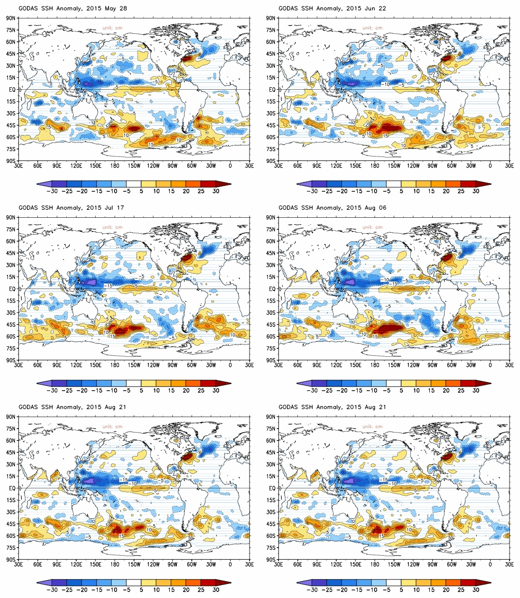
And sea surface heights off the US East Coast are more than 30 centimeters (one foot) above the 1979 to 2015 average.
And sea surface heights off the US East Coast are more than 30 centimeters (one foot) above the 1979 to 2015 average.
(Global
sea surface height anomalies off the US East Coast are more than a
foot (30 cm) above the 1979 to 2015 average. A clear sign that the
Gulf Stream is slowing down, perhaps by as much as 15-30 percent.
Complete shut down of the Gulf Stream, though unlikely without
extremely large melt outflows from Greenland, would result in a very
dangerous 1 meter sea level rise. An impact that is primarily driven
by ocean current change. Sea level rise by thermal expansion and
glacial melt would, necessarily, pile on top of this bulge of backed
up waters. Image source: NOAA’s
Climate Prediction Center.)
World
Ocean Heartbeat Fading
This
past March, after observations of rising sea levels off the US East
Coast, extreme positive sea surface temperature anomalies in the same
region, and a critical slowing down of North Atlantic over-turning
recorded throughout the 20th Century, Professor Stefan
Rahmstorf published
this earth-shattering paper in the scientific journal Nature.
The
paper meticulously recorded a slow-down of bottom water formation in
a region of the Atlantic Ocean south of Greenland. The period studied
included all of the 20th Century and the first one and one half
decades of the 21st Century.
Rahmstorf concluded that Greenland ice sheet melt — starting around 1900 and spiking after 1975 — was having a profound impact. Cold, fresh water issuing out from Greenland was cutting off the flow of heavier, salty water transported northward by the Gulf Stream. It was preventing larger portions of that water from sinking. And it was slowing down the Gulf Stream together with a host of other ocean circulation driving currents.
Rahmstorf concluded that Greenland ice sheet melt — starting around 1900 and spiking after 1975 — was having a profound impact. Cold, fresh water issuing out from Greenland was cutting off the flow of heavier, salty water transported northward by the Gulf Stream. It was preventing larger portions of that water from sinking. And it was slowing down the Gulf Stream together with a host of other ocean circulation driving currents.
A
system vital to both the life and health of the world ocean and
global weather stability was entering an arrest. In other words, the
world ocean heartbeat was fading.
The
Gulf Stream Train Wreck
Since
the publication of Rahmstorf’s
paper,
evidence of a bottom water formation interruption and a subsequent
Gulf Stream train wreck continued to pile up. Sea surface
temperatures off the US East Coast, during summer time spiked to as
high as 85 Fahrenheit (29.3 C) off the coasts of New York and New
Jersey. And regions off Nantucket hit as high as 80 degrees
Fahrenheit (26 C). That’s between 7-10 F (4-6 C) hotter than
average for an already typically warm Gulf Stream.
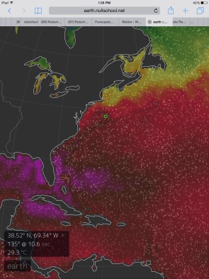
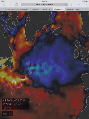
(Left
frame image shows Gulf Stream waters spiking to 29.3 C or 85 F off
New York and New Jersey. Temperatures in the range of 7-10 F [4-6 C]
above average. Right frame image shows cool pool development in the
typical bottom water formation zone between Greenland, England and
Newfoundland. Combined with the ocean current overlay, which shows
widespread meandering, this hot south, cold north ocean surface
dipole is an indication that the Gulf Stream is slowing down and that
bottom water formation is weakening. Image source: Earth
Nullschool.)
Further
north, the opposite is happening. In the region east of the Grand
Banks where the Gulf Stream currents typically flow strongly, there’s
only a weak, meandering, confluence. The Gulf Stream appears to have
hit a barrier. It has bottled up off the Northeastern US Coast. And
it appears reluctant or unable to flow past mid-ocean.
As
a result, a broad zone between England, the Southeastern Coast of
Greenland and Newfoundland lack the warm, salty inflow of a strong
Gulf Stream. Sea surface temperatures range from 2-7 F (1 to 4 C)
below average. The northward progress of heat from the Gulf Stream is
tapering off. And this cut off of heat flow from Equator to mid
latitudes shows more and more as the development of an anomalous cool
pool continues throughout.
Taking
in the entire North Atlantic, what we see is a weather-destabilizing
hot-cold dipole. The warm waters are backed up off the US East Coast.
This is evidenced by both the very warm sea surface temperatures and
by an extreme increase in sea surface heights by 1 foot over a broad
region. And to the north, we have the climate change signature cool
pool.
Anomalous
Storms Strike England During Summer
This
Gulf Stream train wreck and related cool pool development has already
done a bit of a number on UK weather this summer. A series of gales
and heavy rainstorms have slammed into the UK Coast — bringing
heavy seas and torrential rains. One months worth of rainfall fell
over parts of the UK during the past week alone. And
with more storms on the way it appears that August of 2015 may be the
wettest ever recorded.
It’s
a changed climate state that Dr. James Hansen warned of in a recent
paper.
One that means more powerful storms for the North Atlantic as the
Greenland Ice Sheet spews out greater and greater volumes of water
and ice. Ever since 2012, we’ve seen a tendency for these kinds of
anomalously powerful storms. And more rough weather is certainly on
the way.
(During
the winter of 2013 and 2014, storms reshaped the coastlines of the
British Isles. But this was just the start. For
the North Atlantic is now in the process of firing up an age of
storms.
Image source: AGU.)
The
Fall forecast is calling for the strong gales that we’ve already
seen to
continue to intensify through at least October and November.
Strong storms that will draw energy by the high differences in sea
surface temperatures in the North Atlantic, but also, possibly, from
an El Nino-amplified storm track causing powerful troughs to begin to
dig in off the US East Coast. A situation that could set up a kind of
trans-Atlantic storm firing line.
The
long term forecast, however, is even worse. With Greenland just
beginning to shed more and more of its ice, the cool pool off England
will tend to intensify even as the hot pool off the US East Coast and
within the Gulf of Mexico heightens. A screaming, storm-generating
temperature differential that such melt will worsen as the decades
wear on and if human fossil fuel burning continues to add more heat
fuel to this already developing dangerous situation.
Links:
Hat
tip to Spike


No comments:
Post a Comment
Note: only a member of this blog may post a comment.