November-Type Gales Hit England in August — Looks Like a Weird Atmospheric Response to El Nino + Climate Change May Be Unfolding
4
August, 2015
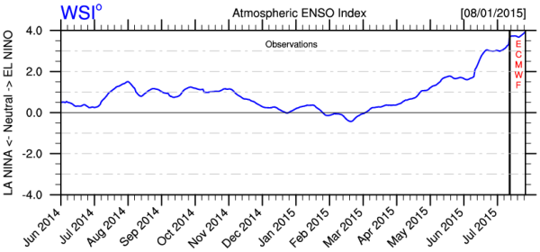
(Atmospheric
El Nino Index by WSI shows a very strong atmospheric response is
unfolding. But long range weather maps, long range NOAA forecast
shows an atypical pattern for El Nino. Image source: WSI.)
They
say that a picture can paint a thousand words. How about a graph that
exceeds 100 El Ninos? It may not jump out at you at first, but that’s
what we’re looking at above.
This
graph, provided by Weather
Channel Affiliate WSI (and
based on atmospheric data collected by NOAA) represents intensity of
atmospheric response patterns to El Nino. Typically, this means
cloudiness at the Central Pacific Equator, the propagation of near
equatorial westerlies, atmospheric wave propagation in the Jet
Stream, and storm track amplification. In other words,
teleconnections.
On
the left side of the above graph, we see positive and negative
numbers indicating standard deviation correlation to an ENSO neutral
state. Push into 2 standard deviation range either high or low and
you’re getting about a typical El Nino or La Nina response from the
atmosphere. And ever since June we’ve been in the 3 standard
deviation or about top 10 percent of El Nino response range.
That’s
a pretty strong ocean to atmosphere signal. But it pales in
comparison to what’s being predicted. Looking ahead, the Euro
weather model then pushes us all the way up to a 4 standard deviation
event (or top 1 percent of atmospheric response rates) by
early-to-middle August. This is an extreme response to El Nino. One
that could have some amazing impacts come Fall, or possibly sooner
(see North Atlantic storm discussion below), especially when we take
into account some of the added impacts of human caused climate
change. Should such a response emerge, both the US Southeast and Gulf
Coast could be in for some extremely severe storms.
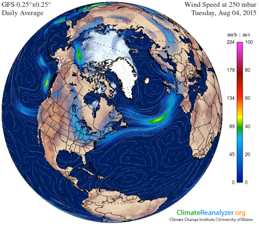
(A
rather deep trough for Summer-time swings down through the Eastern
US. Image source:Climate
Reanalyzer.)
For
the US, such a strong atmospheric response to El Nino forcings would
tend to indicate a powerful trough digging in through the Eastern
half of the country, even during summertime. And while we do see a
rather strong trough for this time of year setting up over and
extending down from the Hudson Bay region of Canada, we do not see an
overall suppression of summer-time heat and potential for greatly
increased precipitation that would typically occur under such a
pattern, as yet.
Instead
and somewhat oddly, the pattern has kicked energy out over the ocean
— fueling the North Atlantic storm track and powerful oceanic cold
core cyclones at a time when such events should be rare. Yesterday, a
gale hammered Scotland and Ireland, kicking up seas west of England
into a frenzy of 30 foot swells. To say this event is odd for
summertime is a bit of an understatement. Sans tropical storms
swinging north, the higher Latitude regions of the Atlantic are
typically calm this time of year.
Winter-Type
North Atlantic Gales During Summer
But
living in typical times we are not. Greenland melt is ramping up. And
so we see the start of a Heinrich
Event-like cool pool in the North Atlantic.
Call it a baby Heinrich or a precursor or whatever you like. But it’s
there. And it’s anomalously cool. And it’s going to influence the
weather regardless of whether we like it or not. It’s an event
related to both fresh water flow into the North Atlantic and an
associated decline in the strength of the Gulf Stream. This odd
summer North Atlantic storm generation is then, perhaps, due to a
teleconnection between the strong atmospheric signal of El Nino and
the underlying signal of human-forced climate change. Such a
teleconnection would tend to shift the El Nino related trough a bit
eastward and result in an amplified North Atlantic storm track. Which
is exactly what we are seeing.
(It
looked like a North Atlantic winter storm. But this screen capture of
30 foot swells due to a powerful gale off England was taken late last
night [August 3rd]. For those familiar with typical summer patterns
for the North Atlantic this should be a moment that inspires
head-scratching. One with an uncanny similarity to patterns predicted
in a recent paper by Dr.
James Hansen.
Image source: Earth
Nullschool.)
NOAA
long range forecasts are also picking up the signal of powerful storm
track intensification over the Gulf Coast and the Southeastern US.
Such a prediction hints at a strong storm track running diagonally
across the Atlantic from Florida to England and aligned with a trough
edge running through that broader region. It’s a pattern that could
put England in the firing line for severe winter storms yet again.
For the US, the upshot is powerful storms slamming a region from
Texas through the Carolinas from September through February. Florida,
Coastal Georgia and the U.S. Gulf Coast are particularly hard-hit in
the forecast. But we also shouldn’t rule out some strong bombs
impacting the Mid-Atlantic region before they tear off across the
ocean.
No
Significant Drought Relief for California?
Sadly,
the atmospheric response to El Nino is not pushing forecasts for a
wet winter for the US West Coast. Monsoonal moisture hits the US
Southwest during September and October, but barely touches California
in the forecast. The moisture pattern then retreats eastward. Heat
and dryness are particularly focused in the region of Washington,
Oregon, Idaho and Montana. Abnormal warmth is also predicted to
remain in place over Alaska.
(NOAA
long range forecast finds little drought relief for the US West Coast
this winter even under the influence of a predicted powerful El Nino.
Image source: NOAA
CPC.)
This
pattern appears to indicate that the NOAA models are calling for the
Ridiculously Resilient Ridge and the hot Blob of water off the US
West Coast to mostly remain in place. An overall very bad forecast
considering El Nino’s predicted intensity and the currently
indicated strength of atmospheric response.
It may be that cooling in
the North Atlantic associated with Greenland melt and Gulf Stream
weakening is having such a powerful impact on the Jet Stream that El
Nino cannot over-ride — instead solidifying the Pacific Ridge to
Atlantic Trough fixed atmospheric wave and dumping its teleconnection
influence into the firing range that the North Atlantic is steadily
morphing into.
To
this point, it’s worth noting that long range model forecasts of
this kind can carry with them a rather high error bar. The
ocean-atmosphere forcing of the predicted super El Nino will likely
result in some rather dramatic wrenchings of climate system. And for
such an El Nino to fail to over-ride the West Coast block would have
some very serious added impacts on down the line.
Links:
(Please
support publicly funded, non-special-interest based science, like the
fantastic work provided by NOAA and NASA, without which this report
and the reports provided by Climate Reanalyzer, Earth Nullschool, and
WSI would not be possible.)


No comments:
Post a Comment
Note: only a member of this blog may post a comment.