Screaming Hot Pacific A Sea of Storms as 2015 El Nino Breaks Records For Spring Intensity
8
July, 2015
The
currently strengthening El Nino enters the record books for Spring
heat even as it throws off an extreme surge of tropical cyclone
activity in the Western Pacific…
*
* * *
For
a swath of ocean from the Date Line to 120 degrees West Longitude
(Nino 3.4) it’s been a rather hot spring. Sea
surface temperatures for the benchmark zone hit 4th highest in the
regional climate measure (starting in 1950) for the period.
With almost every climate model predicting continued El Nino
strengthening through Fall, this early benchmark would be some cause
for concern. Averages for the region hit a positive anomaly of +0.85
C, just behind record holder 1992 at +1 C. But even more
disconcerting was the extreme warming through another marker zone
just to the west. A heat build-up which shattered all previous
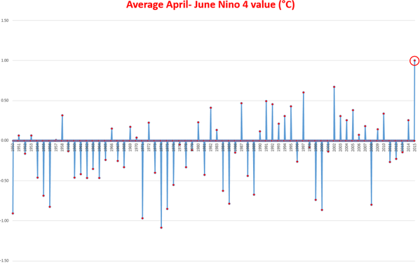
seasonal records for the period. For the Nino 4 region stretching
from 160 East to 150 West Longitude, the April to June time frame for
2015 was the hottest ever seen:
(Nino
4 hits new record hot temperatures for Spring of 2015, crushing all
previous record holders. Data Source: NOAA
El Nino Monitoring.
Image source: Eric
Blake.)
Hotter,
in fact, by a long shot — crushing
the previous all-time positive anomaly record of +0.65 as it surged
to +1 C above the regional average.
For an El Nino that is still ramping up against the climatological
trend for Summer to Fall cooling, these early markers may well serve
as an indicator for future intensity.
The
new record also came before the most recent surge in thunderstorm
activity over the Western Pacific set off a major burst of westerly
winds. A
powerful atmospheric back-blast that will likely generate a third
warm Kelvin Wave and further tip the Eastern Pacific into ever more
extreme high temperature values.
An extraordinary burst of storms in its own right powered by record
levels of moisture bleeding off this zone in the Pacific and an
amazing temperature gradient that is now starting to form from the
higher temperature deltas along and near the Equator.
(West
Pacific a sea of storms on July 8 as El Nino continues to show signs
of intensification. Image source: LANCE
MODIS.)
By
earlier this week these storms had coalesced into three powerful
tropical cyclones — Linfa, Chan-hom, and Nangka. Two of which —
Chan-hom and Nangka — now rate as super typhoons on the Hong Kong
intensity scale (100 knots or greater maximum sustained wind speed).
Chan-Hom
is predicted to plow into the China coastline near Shanghai over the
next 36-48 hours as a 115 knot (132 mph) major cyclone. On the
satellite shot, this beast clearly displays a substantial footprint.
Joint
Typhoon Warning Center reports
show an extensive tropical storm force wind field stretching out up
to 145 nautical miles from the storm’s center with hurricane force
winds extending out 35 nautical miles. Linfa is also predicted to
interact with land over the next two days — skirting Taiwan as a
moderate strength tropical storm before retrograding southward into
the Northern Philippines. Nangka is expected to skirt Guam, then
remain over open ocean through the 13th of July.
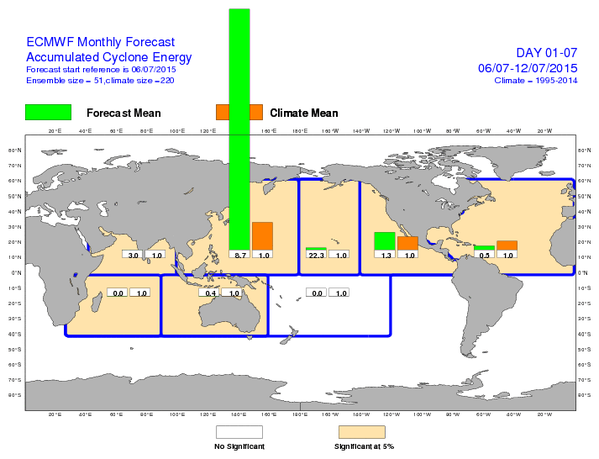
All
together, these ocean heat and moisture fueled storms represent an
extraordinary accumulated cyclone energy anomaly for the region. One
that is forecast to hit nearly nine times the mean value for the
Western Pacific for the seven day period of July 6 through July 12.
Yet another off-the charts weather reading coming from the still
strengthening and global warming amplified 2015 El Nino:
(ECMWF
forecast model shows extreme cyclone accumulated energy potentials
for Central and Western Pacific. Image source: ECMWF.)
In
context, we can add this intense Western Pacific cyclonic outburst to
a long list of related 2015 El Nino and global warming influenced
events (more on this in a future post). These include widespread
South American drought, the Ridiculously Resilient Ridge and
associated North American Wildfires, Western North American droughts,
Arctic Sea Ice impacts, The Central US Floods of May and June, a
delayed Monsoon and deadly heatwave switching to extreme floods in
India, a mass casualty heatwave in Pakistan, and floods in Thailand
and China (among others).
By
later this Fall, if the strong to monstrously strong El Nino
predicted in the model runs does emerge, other significant El Nino
related impacts may manifest due to a related strengthening of the
Pacific storm track. As a result, we could see a switch from epic
drought to epic deluge for the US West Coast. It’s a narrative that
has become all too common as human forced global warming in the range
of 0.8 to 1 C above 1880s values continues to enable far more extreme
hydrological weather events than we are used to (drought and flood).
El Nino’s hand in increasing evaporation over the Equatorial
Pacific, when combined with the broader impact of human forced
warming, is one that generates a still higher risk for these kinds of
extreme events. And with El Nino forecast to be strong to absolutely
monstrous, it is highly advised that US West Coasters keep a weather
watch out for the coming Fall.
Links:
NOAA
El Nino Monitoring (Please
support publicly funded, non special interest based science.)
Hat
tip to Colorado Bob
Hat
tip to climatehawk


No comments:
Post a Comment
Note: only a member of this blog may post a comment.