Arctic Heatwave Forecast to Crush Northern Hemisphere Snow Cover This Week
The
Russian side of the Arctic is heating up.
2
June, 2015
A
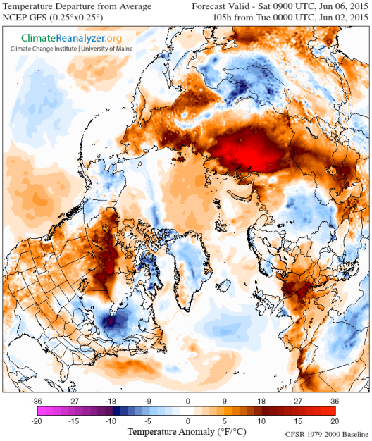
high amplitude ridge in the Jet Stream is forecast to develop atop
the Yamal region of Russia, expand northward over the Kara and Laptev
seas, inject a plume of anomalously warm air over the polar region,
and then proceed on along the Arctic Ocean shores of Siberia. Beneath
this ridge, temperatures over the Arctic Ocean will spike to +1 to +4
C above average while temperatures over land will hit extreme +20 C
and higher anomalies.
(Arctic
heatwave invades Siberia in the GFS forecast for later this week as
depicted by Climate
Reanalyzer.)
Arctic
Ocean zones are forecast to see temperatures climb above freezing for
much of the 80 degree North Latitude zone. Over Siberia, land-based
temperatures are predicted to range from the 40s and 50s along the
Arctic Ocean boundary and climb to the 60s to 80s in regions just
inland.
As
temperatures tend to flatten out over Arctic Ocean waters and as
permafrost zones in Siberia are used to far cooler readings during
Northern Hemisphere Summer, the predicted heatwave is likely to have
some rather strong impacts should it emerge. Most notably, snow cover
over remaining land and sea ice is expected to see a rather extreme
reduction over the next seven days. In other words, GFS forecast
models show Northern Hemisphere snow cover basically getting crushed:
(Massive
reduction in Northern Hemisphere [NH] snow cover predicted coincident
with Siberian Heatwave later this week. Left frame shows current NH
snow cover. Right frame shows predicted NH snow cover for Tuesday,
June 9. Image source: Climate
Reanalyzer.)
Sparse
remaining snow cover in Northeast Siberia along the East Siberian
Arctic Shelf coastal zone is expected to be pretty much wiped out.
One foot average snow cover along the shores of the Laptev and Kara
seas is also expected to melt. And a broad section of remaining snow
upon the sea ice is predicted to retreat away from the North Polar
region — receding back toward the final haven near Greenland.
Snow
is important for spring and summer-time Arctic temperature moderation
due to the fact that it provides insulation to sea ice and permafrost
as well as serving as a reflective, high-albedo surface that bounces
back some of the incoming heat from the 24-hour seasonal Arctic sun.
Snow melt, on the other hand, serves to form albedo-reducing melt
ponds over the Arctic Ocean sea ice during summer. A critical factor
in late season melt forecasting in which more June melt ponds tend to
mean lower sea ice totals by end season. In addition, snow melt fills
permafrost zone rivers with above-freezing waters that then flow into
the Arctic Ocean — providing yet another heat forcing to the sea
ice.
Conditions
in Context
This
weekly trend and forecast is consistent with an ongoing tendency
during 2015 for strong ridge formation and warm air slot development
over both Alaska and the Yamal region of Russia. The high amplitude
ridges also likely have teleconnections with larger weather patterns
such as El Nino in the Pacific, the warm water pool (hot blob) in the
Northeast Pacific, and record low sea ice extents continuing for most
of Northern Hemisphere Spring. Observations
that are also consistent with the predictions made by Dr. Jennifer
Francis that are a direct upshot of polar amplification set off by
human-caused warming of the global climate system.
(GFS
model forecast as depicted by Earth Nullschool showing ridge
Northwest Territory, trough Greenland and North Atlantic, ridge Kara
and Laptev region of Siberia. A dynamic that may be the result of
teleconnections set off by factors related to human-caused climate
change. Image source: Earth
Nullschool.)
It’s
worth noting that many of these factors are self reinforcing. For
example, more sea ice melt results in higher amplitude wave formation
in the Jet Stream. Higher amplitude wave formation in the Jet Stream
transports more warmth to the Arctic environment, resulting in more
sea ice and snow melt which in turn weakens the Jet Stream further. A
longer-term amplifying feedback of Arctic carbon release may also be
in play (hinted at by an overburden of both CO2 and methane in the
local Arctic atmosphere), which would also contribute to the
conditions we now observe.
A
final feedback, this one somewhat negative, occurs as a result of
Greenland Ice Sheet (GIS) melt. Large cold, freshwater outflows from
GIS into the North Atlantic result in localized cooling in that
region. This feedback (also related to AMO weakening) enhances trough
formation throughout the North Atlantic region adjacent to Greenland
and the Canadian Archipelago. A final potential teleconnection to the
ridges we see forming over both Yamal and the Alaska/Northwest
Territory zone.
Links:


No comments:
Post a Comment
Note: only a member of this blog may post a comment.