2015
El Nino to Bring Back-to-Back Hottest Years on Record?
4
March, 2015
For
the past six months, the Pacific Ocean has been very, very warm. A
vast and unsettling expanse of record heat building from the tropics
on through the mid lattitudes and into the Arctic.
Sea
surface temperatures across a broad swath of ocean from the equator
on north and eastward have consistently measured between 0.5 and 5
degrees Celsius above average. A lazy reverse C pattern of heat
stretching from the equator running up along the west coast of North
America and then re-curving westward just south of the polar one.
It
is a pattern that is indicative of a well developed positive phase
Pacific Decadal Oscillation. A kind of pattern that results in very
warm sea surface temperatures for much of the Pacific. And a pattern
that tends to favor the formation of El Nino.
As
of December 2014, PDO values had climbed to their highest on record.
And with these high sea surface temperature values related to PDO,
the Pacific also seemed to be quietly settling into what, at first,
appeared to be a mild El Nino.
Chances
For 2015 El Nino Rise
The
key value for El Nino is a measurement for sea surface temperatures
along a region of the Central Equatorial Pacific known as Nino 3.4.
Stretching from about 160 West to 120 West Longitude, this expansive
zone of ocean waters below Hawaii tends to warm with the onset of El
Nino.
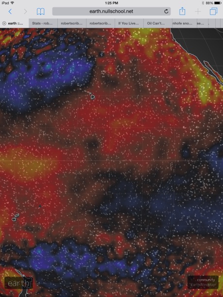
(Nino 3.4 zone in center of frame on the Earth Nullschool Sea Surface Temperature anomaly map for March 4, 2015 shows warm waters again building in the Central Pacific. Averages in the zone for this date are around +0.75 C above normal. Note the + 2 C hot pool just to the western edge of the zone [orange-yellow coloration] and the +4 C hot pools [yellow coloration] off the US West Coast. Image source: Earth Nullschool. Data Source: Global Forecast Systems Model.)
The
threshold NOAA uses to determine El Nino is a sea surface temperature
anomaly for this area of +0.5 degrees C above average. And ever since
September of 2014, sea surface temperatures have been hovering above
the +0.5 C line.
NOAA’s
determination for El Nino requires 5 three month average periods in
which Nino 3.4 exceeds this mark. And it looks like, so far, four out
of five of those periods have met the El Nino requirement. September,
October and November (SON) averaged +0.5 C. October, November and
December (OND) averaged +0.7 C. And November, December and January
(NDJ) averaged +0.7 C. With all weekly measures for February coming
in near or above January values, it appears the DJF value will post
somewhere near +0.6 C (please see NOAA’s
Weekly ENSO Status Report).
Even
if March values dropped to +0.4 C, a weak El Nino would emerge in the
Pacific during Spring of 2015. However, sea surface temperatures for
this zone are not falling as we enter March. They are instead ramping
higher.
New
Warm Kelvin Wave Forming
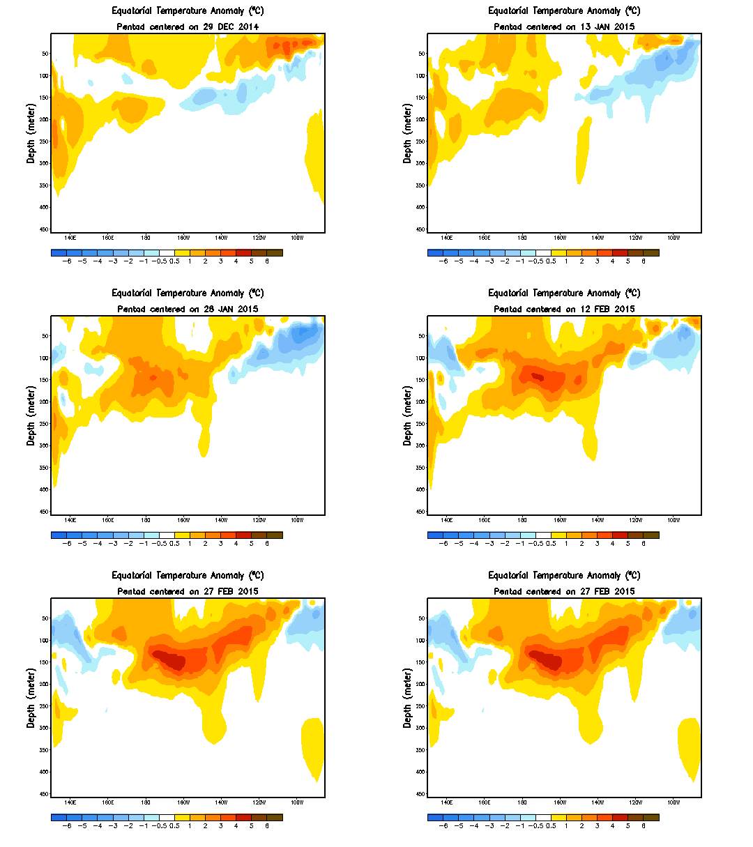
For
beneath the Central Pacific a new pool of warm water is forming. It
is rising to the surface, providing yet another shot of heat to an
equatorial region teetering on the threshold of El Nino. A new Kelvin
Wave that carries with it more than enough energy to tip the scales
for a 2015 event:
(Warm Kelvin Wave again forming in the Pacific. This event will likely be enough to push 2015 into El Nino. Image source: NOAA/CPC.)
The
Kelvin Wave will slowly rise to the surface, elongate and transfer
some of its latent heat to the sea surface and atmosphere. Driving
this Kelvin Wave along are west wind backbursts that today were in
the range of 25 mph sustained with gusts to 35. These gusts are
continuing to drive warm water eastward and downward, providing more
energy for the Kelvin Wave as well as any emerging El Nino. A set of
winds that could well grow stronger as a weather pattern know as
the Madden
Julian Oscillation (MJO) is
predicted to ramp up, bringing stormy weather and more counter trade
wind air flows across the Western Pacific equatorial zone.
These
combined factors have spurred Australia’s Bureau of Meteorology to
post a renewed El Nino Watch. NOAA is also showing a heightened
chance for El Nino, with a near 60% probability for the event
emerging late winter or early spring.
Meanwhile,
some models for the Nino 3.4 region show continued warming along with
a heightening El Nino throughout 2015:
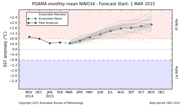
(BoM Nino 3.4 sea surface temperature anomaly (SSTA) prediction model shows El Nino building throughout 2015. Note that the Australia BoM SSTA threshold is +0.8 C for Nino 3.4 while NOAA’s threshold is SSTA in excess of +0.5 C for seven months running. Image source: Bureau of Meterology.)
Back-to-Back
Record Hot Years?
The
+1.9 C peak and rising prediction for Nino 3.4 in the above graphic
is indicative of a relatively strong El Nino by mid November of this
year (for reference, the 1998 Super El Nino peaked at around +2.3 C
for this region while 2010 peaked at +1.5 C). But even a far milder
El Nino would likely have far-ranging consequences, especially in a
world that has been pushed to keep warming and warming by the massive
human fossil fuel emission.
All
that heat again building along the equatorial Pacific would likely
shove the Earth’s oceans and atmospheres again above record
thresholds. And that would mean that 2014’s record as the hottest
year for the Earth’s surface may only stand for but a few seasons
more.
The
risks for another record hot year for 2015 are, therefore, again
rising.
Links:
Hat
Tips:
Colorado
Bob
Phil


No comments:
Post a Comment
Note: only a member of this blog may post a comment.