The
Polar Circulation is So Wrecked That Surface Winds Now Rotate
Around Greenland
28
November, 2014
In
a normal world, during a normal late fall and winter, cold air would
concentrate over a thick northern ice pack near the North Pole. The
sea ice would be dense enough, unbroken enough, to lock a warmer
ocean away beneath. The cold air core would be encircled by strong
winds — both in the upper levels and at the surface. An atmospheric
cold zone that would tend to be pretty steady, taking strong weather
anomalies to drive it off a firm base of chill air.
In
today’s world, the Arctic Ocean is warming. Connected to an also
warming world ocean, the waters provide a launching platform for the
added, human-driven heat. The surface sea ice is thus far thinner —
containing less than 50 percent of the volume it boasted during the
late 1970s. And, during this time of year, an extraordinary
overburden of greenhouse gasses (primarily CO2 and Methane)
continuously traps extra long wave heat radiation throughout the dark
winter night.
All
that extra heat gathering over the Arctic Ocean makes the cold air
core far less stable. More and more frequently it is driven from its
previous haunt near the North Pole. A climate change refugee looking
for a cold air pool as temporary asylum from the inexorably building
heat.
To
the south, the still solid but increasingly endangered ice sheets of
Greenland provide, perhaps, the most likely haven. So as the high
Arctic heats up, the cold air re-centers over Greenland. And the
result is a rather odd configuration in which atmospheric currents
begin to displace southward, encircling Greenland rather than the
polar regions. A disruption that results in a ripple of changes
throughout the Northern Hemisphere — including serious alterations
to the storm track and a far greater likelihood of the extreme
weather producing planetary wave patterns.
Observational
Support for Cutting-Edge Theories
The
above described scenario draws from a number of cutting edge
scientific theories. The first is Hansen’s Storms of My
Grandchildren theory — in which a combination of polar
amplification and enhanced Greenland melt drive severe changes to the
Northern Hemisphere storm track, resulting in nightmarish weather.
The second is the enhanced planetary wave theory, proffered by Dr.
Jennifer Francis, in which Arctic warming drives severe changes and
distentions in the Northern Hemisphere Jet Stream. The two theories
are related in that Arctic warming, in both cases, is a primary
driver of extraordinary climate and weather changes.
Thus
far, we have seen growing evidence to support these theories,
especially Dr. Francis’ theory, as ever since the mid 2000s we have
observed an increasing prevalence of weak Jet Streams, strong
planetary waves, and powerful meridional flows driving warm air into
the polar zone, but also driving cold air out. Hansen’s Storms of
My Grandchildren theory got a boost last year as a southward shifting
cold air circulation ignited a powerful North Atlantic storm track
that set off the roughest winter on record for England and the UK.
This
year, we see similar weather phenomena related to these theories. The
inundation of Buffalo with one year’s worth of snowfall in just two
days was driven by a powerful planetary wave pattern directly
associated with polar warming. A similar planetary wave is, today,
threatening to dump more than a foot of snow across regions of the US
Mid-Atlantic through New England. A January type winter storm on
Thanksgiving that was preceded by 70 degree temperatures.
Not
What Our Weather Models are Used to — The Greenland-Centered Cold
Air Core
Today,
we have yet one more pattern emerging that was predicted by these
theories — polar air circulation centering around Greenland:
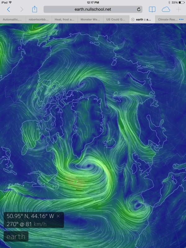
(Surface air flow encirclements of Greenland similar to conditions observed above were highly anomalous during the 20th Century. During the 21st Century, such a storm enhancing pattern is likely to become much more prevalent as an up-shot of human-driven polar warming. In the above shot, note the low spinning off Spain and heading toward Morocco off an anomalous and persistent dip in the Jet resulting from this abnormal pattern. More floods potentially on the way for that already hard-hit region. Image source: Earth Nullschool.)
In
the above image, provided by Earth Nullschool and collecting data
from US based global climate observations and models, we find warm
air from the subtropical Atlantic being driven northward by first a
mid-ocean high pressure system and then by a powerful low raging away
off the southern tip of Greenland.
The warm air flow rises north then
joins with a continental flow rising off of Europe to cross the North
Atlantic and the Barents Sea. Traveling along a cold frontal boundary
sweeping out from Greenland, the warm air current surges up over
Svalbard and toward the North Pole.
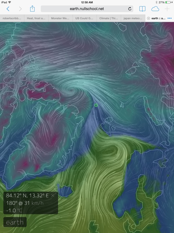
This
warm air flow drives temperatures in a region within a couple hundred
miles of the North Pole to 30.5 degrees Fahrenheit — warmer than
current temperatures in central Pennsylvania and well over 36 degrees
above average for this time of year in the far, far north:
(Svalbard and regions near the North Pole heat up as an extraordinary warm air wedge drives far, far north. Image source: Earth Nullschool.)
This
extraordinarily warm air then becomes entrained in another low north
of Greenland before following a polar air flow driving down over the
Canadian Archipelago and Hudson Bay. A powerful north-south flow
drawing over Baffin Bay into the strong low south of Greenland closes
the loop. Thus we find Greenland encircled by winds, its cold air
core far offset from the pole as the region over the Arctic Ocean
warms.
As
we can see in the surface wind map (top map), the surface air flow is
running a complete circuit ’round Greenland. The result is that the
cold air core driving NH atmospheric circulation at the surface is
now centered over Greenland and Baffin Bay. It is displaced many
hundreds of miles south of the North Pole. And the North Pole itself
has become over-run by a warm air flow at the periphery of the cold
air circulation’s center.
Upper
level wind patterns are similarly disrupted with a cold upper air low
churning away over Baffin Bay and a second cold core circulating over
Central Siberia. In both cases, in the upper levels near the Jet and
at the surface, the region of the Arctic Ocean is disassociated from
the cold air centers and related atmospheric circulation. A set of
conditions that has come to very well resemble those predicted by Dr.
Francis, or worse, look more like a precursor to Hansen’s Storms of
My Grandchildren scenario.
In
this case, for today, the weather observations match the
warming-induced pattern just as predicted.
Mainstream
Weather Coverage Abused by Changing Climates (I’m Looking at You,
Weather Channel)
Mainstream
meteorologists, including those at the Weather Channel, continue to
cover current weather as if it is occurring under traditional
conditions while only providing sideways references to cutting edge
science related to observed atmospheric warming. A new subset of the
science that provides much greater insight into what may actually be
happening and is a very useful tool for weather prediction in the
currently altered and radically changing climate state.
Unless
such meteorologists begin paying attention to the anomalous changes
that are plainly visible in the observational data (changes that I
have no trouble finding and identifying after reading the science
provided by Hansen and Francis) they will be left behind by events
that are increasingly dissonant to their current institutional
understanding. A cautionary tale that European
meteorologists, baffled
by failures of climate models to predict record floods from training
of low pressure systems into Morrocco off a persistent and anomalous
dip in the Jet Stream this week, can
bear testament to.
Like
geologists who failed to take into account for plate tectonics theory
in the mid 20th Century, meteorologists adhering to old weather
prediction methods risk becoming outmoded and less relevant to
current, and rapidly evolving, climate realities. The new global
warming science both bears out in the observational data and in its
usefulness to predict extreme events — so, for the sake of
accuracy, it needs to be included.
Links
and Credits:
Dr.
Jennifer Francis
Dr.
James Hansen
Hat
Tip to Mark From New England
The
Weather Channel’s Weather Geeks (Who Need to Wake up and Smell the
Polar Amplification)


https://www.facebook.com/notes/kevin-hester/the-polar-vortex-explained/10204139581262461
ReplyDelete