

MAJOR
COMPUTER MODEL CHANGE: NOW GRAVE DANGER ALSO FOR GEORGIA &
FLORIDA

11
September, 2018
The
very latest computer models on Hurricane Florence show a DRAMATIC
AND DANGEROUS CHANGES to
the forecast.
First,
the EURO super-computer model is now saying Florence
may NOT come fully ashore in North Carolina, but instead come right
up to the shoreline and stall . . . . for
36 Hours!
That
would mean no
weakening,
and hurling 20 to 22 FEET of STORM SURGE into North and South
Carolina for a full 36 hours.
WORSE
. . .
The
computer models are NOW saying the
storm will then turn SOUTH along the entire coast of South Carolina,
all the way down to Savannah, GA.
If
this new model forecast is correct, evacuations
are strongly advised for the entire coast of the state of Georgia,
from Savannah, all the way down to Jacksonville, Florida!
Here's
the model as of 5:00 PM EDT on Tuesday, September 11:

Given the trends toward a strong ridge north of #Florence near the time of landfall, the 12Z ECMWF illustrates how more of a left turn may occur and keep South Carolina and Georgia in the line of fire.
Details unknown; let this be a reminder to be prepared in case things change.
ENSEMBLE OF MODELS


*** BULLETIN ***
226
WTNT31 KNHC 112040
TCPAT1
BULLETIN
Hurricane Florence Advisory Number 50
NWS National Hurricane Center Miami FL AL062018
500 PM AST Tue Sep 11 2018
...DANGEROUS FLORENCE EXPECTED TO BRING LIFE-THREATENING STORM
SURGE AND RAINFALL TO PORTIONS OF THE CAROLINAS AND MID-ATLANTIC...
SUMMARY OF 500 PM AST...2100 UTC...INFORMATION
----------------------------------------------
LOCATION...27.5N 67.1W
ABOUT 360 MI...580 KM SSW OF BERMUDA
ABOUT 785 MI...1260 KM ESE OF CAPE FEAR NORTH CAROLINA
MAXIMUM SUSTAINED WINDS...140 MPH...220 KM/H
PRESENT MOVEMENT...WNW OR 300 DEGREES AT 17 MPH...28 KM/H
MINIMUM CENTRAL PRESSURE...945 MB...27.91 INCHES
Hurricane-force winds extend outward up to 60 miles (95 km) from the center and tropical-storm-force winds extend outward up to 175 miles
(280 km).
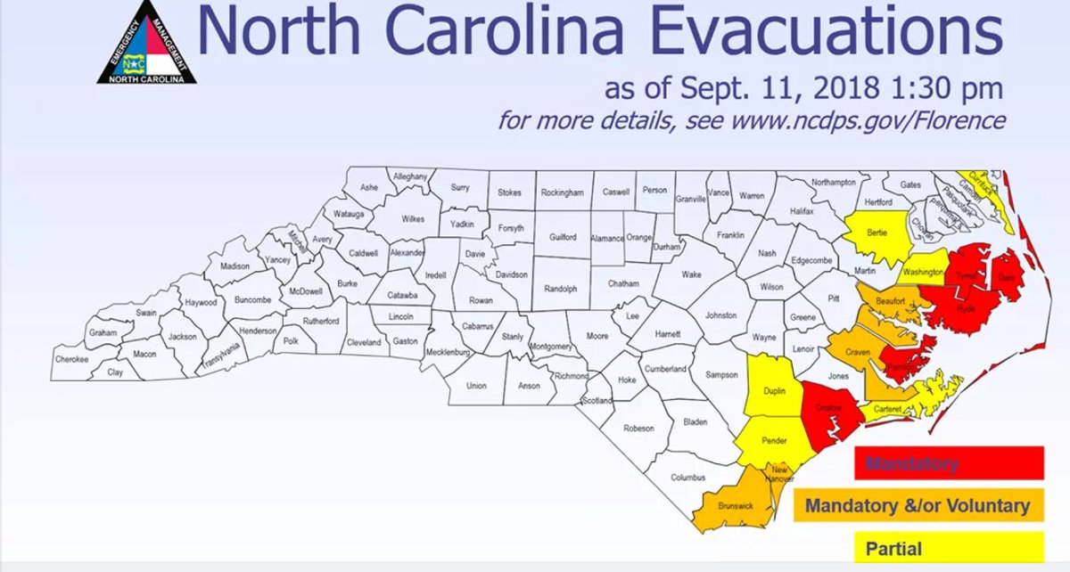
EVACUATION ORDERS:
No comments:
Post a Comment
Note: only a member of this blog may post a comment.